Here is a quick look at my other blogs before you start this one.
My main blog, where the most recent postings on all topics are to be found, is http://www.markmeeksideas.blogspot.com/
If you like this blog on geology and natural history, you will also like my blog about meteorology and biology, http://www.markmeeklife.blogspot.com/ and my blog about natural history concerning glaciers, www.markmeekworld.blogspot.com .
http://www.markmeekniagara.blogspot.com/ is about new discoveries concerning natural history in the general area of Niagara Falls.
http://www.markmeekphysics.blogspot.com/ is my blog about physics and astronomy.
http://www.markmeekcosmology.blogspot.com/ is my version of string theory that solves many unsolved mysteries about the underlying structure and beginning of the universe.
http://www.markmeekpatterns.blogspot.com/ details my work with the fundamental patterns and complexity that underlies everything in existence.
http://www.markmeekreligion.blogspot.com/ is my religion blog.
http://www.markmeekeconomics.blogspot.com/ is about economics, history and, general human issues.
http://www.markmeekprogress.blogspot.com/ concerns progress in technology and ideas.
http://www.markmeekcreation.blogspot.com/ is proof that there must be a god.
http://www.mark-meek.blogspot.com/ is my autobiography
http://www.markmeektravel.blogspot.com/ is my travel photos of North America. http://www.markmeekphotos.blogspot.com/ is my travel photos of Europe.
My books can be seen at http://www.bn.com/ http://www.amazon.com/ or, http://www.iuniverse.com/ just do an author search for "Mark Meek"
Monday, September 1, 2014
The Story Of Planet Earth
This posting is about an entirely new way of thinking about the physical geography of the earth. It leaves virtually no major feature of the earth's surface unexplained, whether on land or on the ocean floor. My suggestion is that you become closely familiar with the Brief Abstract and the Introduction And Glossary, before moving on. The reason that this has not been noticed before is probably that detailed maps of the seafloor have become available only relatively recently, which have made patterns in the topography apparent.
I think that this theory reveals amazing things about the earth, that have never been seen before, particularly those in section L.
Some believe that the continents on earth came from a super-continent, called Pangaia with part of it called Gondwanaland, but with no explanation of where this came from.
One way to navigate this posting is to bring up two windows, and keep one on the following Table of Contents. It would also be good to keep another window on the Glossary, in case a term requires definition. A window could be kept on the satellite imagery of Google Earth, or the Google Earth app, or a good physical geography world atlas.
ALL IMAGES IN THIS POSTING ARE FROM GOOGLE EARTH, GOOGLE MAPS OR, GOOGLE STREET VIEW. MARKUP, USUALLY RED, IS USED TO POINT OUT THE FEATURES THAT ARE REFERRED TO.
A) BRIEF ABSTRACT
Basically, the theory which reveals the explanation for so much of the major features of the earth's topography and the seafloor ridges is that the continents on earth came from three Continental Asteroids. Much debris from the Continental Asteroids was hurtled back into space, where it eventually coalesced by gravity to form the moon. The idea of the moon forming in this way is not new, the asteroid is commonly referred to as "Theia", but my theory expands on it to include the continents as well. Each of the impacts of the Continental Asteroids unbalanced the earth's rotation, by the addition of the new mass, so that the earth's poles and equator underwent three shifts to regain rotational balance by centering one of the poles in the new additional landmass.
The land mass from each continental asteroid was eventually broken up by tectonic activity, driven by the centrifugal force of the earth's rotation. The south pole is today in Antarctica because that was the core of the Third Continental Asteroid. A similar situation is seen on Mars, where the southern hemisphere is higher in elevation and thus heavier, than the northern hemisphere. But this does not upset the rotation of Mars because the south pole is in the center of the heavier hemisphere. What this means is that there have been four polar eras on earth, with the poles and equator in different places in each era. We are in the fourth polar era, after the Third Continental Asteroid. The First Polar Era was before the First Continental Asteroid.
The spin of the earth causes magma, hot molten rock, to emerge from below along the equator by centrifugal force. According to the laws of fluid dynamics, this equatorial emergence must then be balanced by periodic longitudinal lines of emergence in a perpendicular direction to the equator. Each time the poles and equator shifts, to regain rotational balance after the added mass of a Continental Asteroid, these lines of magma emergence must also shift, but magma emergence continues along old longitudinal and equatorial lines for a long time. This scenario explains just so much about the topography of the land and seafloor, and leaves few major features of the earth unexplained.
It makes sense that the pole would move to the center of a new mass in order to balance the earth's rotation. But this means that there has to be another set of poles, which is still earlier, before any Continental Asteroid. The pole moves not necessarily to where the impact site was, but to the center of the new mass, and the two would not be the same if the asteroid landed at an angle.
If the Original Impact Line ends at the Central Asian Plateau, which makes sense, then what about all of the high ground beyond that, Siberia, Alaska, islands of the Canadian Arctic, Greenland, and the high ground of eastern South America?
But where were the original set of poles before any of the Continental Asteroids landed? The Pacific Plate is by far the largest tectonic plate on earth. We know that there will be emergence of magma around poles because the longitudinal lines of emergence, which much balance the emergence along the equator caused by the spin of the planet, converge at the poles.
Hawaii, formed by volcanic magma emergence, is right in the middle of the largest part of the Pacific Plate. There is a straight line of seamounts, that looks just like a line of emergence, which ends at Hawaii from a point to the northwest, west of Midway, where it and another line from the northeast terminate.
On exactly the opposite side of the world from Hawaii, there is the vast Kalahari Basin. This looks just like we would expect if land moved tectonically over the emergence from a former pole.
Notice that when the south pole moved from the south Atlantic at the bend in the Mid-Atlantic Ridge, to the undersea ridge structure around Madagascar, it did not move there in a straight line. It left a clear emergence trail, as the Walvis Ridge that extends southwestward into the Atlantic from the border area between Namibia and Angola, and it is the continuation of that emergence line on line that forms that national border. But this forms an angle of about 45 degrees.
The undersea Walvis Ridge from one former south pole on the way to the next, to the coast of what is now southern Africa.

Why didn't the pole move to it's new position by the most direct route? The reason was that it went around the Kalahari Basin because there was still magma emerging from it from the days when it had been the original south pole.
I got the idea of one of the poles moving to the center of a new mass on the earth's surface, from an asteroid, by the planet Mars. The southern hemisphere of Mars is higher in elevation, and thus heavier, but the planet's rotation is not unbalanced because the south pole is in the center of the heavier hemisphere.
The earth has been impacted by both comets and asteroids. Comets would leave an impact site, but the water from the comets would go into the world's oceans. Asteroids would leave their component material as the world's continents.
Loose pieces that are southward of the Original Impact Line are accounted for by a comet impact on it, such as the Canary Islands and Madeira, which are not volcanic. Sharp mountains do not look volcanic. Islands such as the Azores and Cape Verde are of volcanic origin.
There are four undersea ridges, each representing a former equator, on the floor of the Pacific Ocean west of South America. The fourth is the oldest and faintest. There is such great emergence in the East Indies and Caribbean because that is where all four equators come near to intersecting each other. Like South America, we see all four equators in the East Indies. The present equator is generally the most different from the other three, and this is likely because the last Continental Asteroid was the largest, and thus it's added mass caused the great shift in the earth's axis.
There is a roughly north-south line of unexplained mountains on the east side of three continents-South America, Africa and, Australia. The other line of unexplained mountains, the Original Impact Line, runs east-west.
The earth rotates eastward, and also the Mid-Atlantic Ridge pushes the seafloor apart. This accounts for the locations of South America, Africa and, Australia, relative to the Continental Asteroids which produced them. The fact that the earth's spin pulls toward the equator accounts for the Original Impact Line. If an elongated mass aligned east-west will be pulled in the direction of the equator, such a mass aligned north-south will be pulled eastward by the earth's rotation.
Notice the similarity between Papua New Guinea and Scandinavia. Labrador, Baffin and Ellesmere Islands. Kamchatka Peninsula, Russian Arctic island. These are broken lengths of impact lines that have drifted tectonically. The Great Dividing Range, Papua New Guinea and, New Zealand are impact lines. The remains of the first asteroid could have gotten so far north because it has had more time.
B) INTRODUCTION AND GLOSSARY
This will explain just so much of the large-scale topography of the earth's surface, as well as islands and ridges on the ocean floor. This geological theory leaves virtually no major feature of the earth's surface unexplained, whether on land or on the sea floor.
It is generally believed that a large asteroid, about the size of Mars and known as Theia, struck the earth so that the fragments of the asteroid that were hurtled back into space gradually coalesced by gravity to form the moon. My theory expands on this to explain how this impact formed the earth's continents, as well as the moon, and that there must have actually been three such impacts.
The site of the third, and greatest, impact is what is now Antarctica. The added mass of the impact unbalanced the earth's rotation so that the positions of the poles shifted to get the south pole to the center of the new mass, which is why the south pole is today in Antarctica. The rest of the mass of this Third Continental Asteroid, which "splattered" across the earth's surface, broke away from Antarctica by volcanic activity below and by the pull toward the equator of the earth's rotation. This is already well-known and is referred to as tectonic movement.
If such a collision took place, we would expect that there would be more matter concentrated around the site of the impact. Sure enough, Antarctica is far higher in average land elevation than any of the other continents. Even though the general rule is that the larger a continent, the higher it's average elevation and Antarctica is a relatively small continent.
The Third Continental Asteroid, the one which landed at Antarctica, must have struck the earth at an angle. Thus, there would be a line of land mass from the impact to be seen on the earth's surface. This explains the greatest line of mountains in the world, from the area of Greece and the Balkans, through Turkey and Iran and the Himalayas to the vast high ground of central Asia, which cannot be explained otherwise. This line of mountains, the "Original Impact Line" also held the Eurasian land mass together so that it was not split apart tectonically, and is today the greatest land mass on earth by far. The Rockies and Andes of the western hemisphere, in contrast, were formed by tectonic collision with the Pacific Tectonic Plate.
Other extensive areas of high land, besides this line of mountains and which cannot be otherwise explained are also likely original land mass from the impact of one of the Continental Asteroids.
As the earth rotates, and it used to spin faster than it does now before being slowed by the moon's tidal force, it helps to force magma (hot molten rock) to emerge from below along longitudinal lines by centrifugal force. There is also magma emergence along the equator by the same force. The reason that such magma is forced upward is, of course, to compensate for the new weight of the Continental Asteroids.
Such longitudinal lines of magma emergence converge at the poles to form ridges, if the pole is in a sea as the north pole is, or broad valleys if on land. This is why there is a complex of ridges on the floor of the Arctic Ocean. We can see the similar ridge structures which were left over from the former north and south poles before the earth shifted on it's axis to re-balance it's rotation following the addition of the mass from the Continental Asteroids.
The most recent former south pole is at the island of Madagascar, and the undersea structure around it known as the Mascarene Ridge. The corresponding former north pole is directly on the opposite side of the world, the Great Basin of the western U.S. This was actually the third set of poles, there was one before this. The Canadian Shield is originally of volcanic origin and represents the slow transition of the second north pole to where it is now, the fourth north pole.
The undersea ridge structure around Madagascar, the Mascarene Ridge, is the remnant of the third south pole, before it moved, by the impact of the Third Continental Asteroid, to it's present location in Antarctica.

Former longitudinal lines, from the previous polar era, can also be seen and affect the physical geography of today. The line directly between the former poles is what I have named the Cuba-Phoenix Line, and it forms the island of Cuba and a section of the Mid-Atlantic Ridge. For another line from the previous polar era, we have the Red Sea which points directly at the former (second) south pole.
Notice how the Red Sea, the long and narrow sea between Africa and Arabia, points directly toward the undersea ridge structure around Madagascar, as shown by the red line. That is because it is a former longitudinal line of magma emergence.

When the south pole was at the undersea ridge structure around Madagascar, the north pole was on the opposite side of the world, the Great Basin of the western U.S. The brown area is the Great Basin.

The Great Basin is a vast relatively flat area, caused by the magma emergence of longitudinal lines of magma emergence meeting at the poles, to balance that of the emergence at the equator caused by the rotation of the planet, amidst surrounding mountains.
If the poles shifted, the equator along which magma tends to emerge must also have shifted and former equators can be readily seen today. There are two points, on the opposite side of the world, where the present and former equators will cross, and where we can expect an exceptional volume of magma emergence. Sure enough, we see this in Indonesia and the Caribbean.
Magma emergence along the former equator continues, even after the poles shifted, and explains the line in Europe of the Po Valley and the Balearic Islands, and the broad lowland across northern India.
The broad Po Valley, across northern Italy, with mountains all around as shown by the red line, resulted from the magma emergence along the equator of the last polar era, before the present era. Notice how it merges with the perpendicular Adriatic Sea, to the right, which was a line of longitudinal emergence in the same last polar era. The reason that Venice is sinking is that this emergence, and the resulting broadening of the land, is still mildly active.

Finally, evidence emerged that there was actually three Continental Asteroid impacts, rather than just the one at Antarctica, that caused three shifts in the poles and equator so that there was two more sets of poles and an equator prior to those just described. Just as the earth shifted so that one of the poles would be located around the center of an added land mass on the surface, in order to re-balance the rotation by attaining the lowest energy state, the second north pole was located northwest of the approximate center of the largest part of the largest tectonic plate, the Pacific Plate. The corresponding second south pole was, of course, located on the diametrically opposite side of the earth, in the south Atlantic Ocean.
This ridge structure, in the south Atlantic Ocean centered on the red dot, is the second south pole, after the added mass of the First Continental Asteroid which landed in the south Atlantic, caused the south pole to shift to the center of the new mass, in order to balance the earth's rotation. The Walvis Ridge is above it.

Just as a prominent longitudinal line remained between the former north and south pole before the poles shifted to their present location as the Cuba-Phoenix Line, a corresponding line remains that was a longitudinal line of emergence between the second north pole, west of Midway Island in the Pacific Ocean, to the second south pole. This line is the Hawaii-Midway Line.
The long part of the island of Cuba forms a line with the Valley of the Sun, in which Phoenix is located and which is an extension of the Great Basin, that was the second north pole. This axis of the island of Cuba points directly toward the undersea ridge structure around Madagascar, that was the third south pole.

In the same way, there is a long line of seamounts, undersea mountains, from Hawaii to Midway, and beyond. The second north pole is where this line ends at the end of another such line. I refer to this as the Hawaii-Midway Line. The red dot is where the two lines meet. There is also the ridge structure similar to that of the former pole near Madagascar.

The Hawaii-Midway Line points directly toward the second south pole, that we saw was the circular ridge structure in the south Atlantic Ocean. Both this and the Cuba-Phoenix Line are remnants of the former longitudinal lines of emergence that remain a straight line after the poles have shifted into the next polar era, which is caused by the impact, and added mass, of one of the Continental Asteroids.
Here is a rule that, if one of the poles shifts to the center of a new mass that lands on earth as an asteroid, in order to rebalance the earth's rotation, the pole that does not shift to the center of the new mass, in our case here always the north pole, must then be on a line between the next two new poles, if a second such shift should occur because of the landing of another asteroid.
It goes without saying that a former pole must be on a straight line between the next set of poles, because that would apply to any point on earth. But it would remain on that line if the poles should shift again.
Notice that the original north and south pole, Hawaii and the Kalahari Basin, before the landing of any Continental Asteroids, fits this perfectly. Hawaii, the original north pole in the center of the largest tectonic plate, the Pacific Plate, remains on a direct line between the second south pole, in the south Atlantic, and the new north pole, in the pacific to the northwest of Midway Island.
Then, when the poles shifted again after the landing of the Second Continental Asteroid, the previous north pole, on the Pacific floor to the northwest of Midway, is now on a line between the third south pole, the undersea ridge structure around Madagascar, and the third north pole, the Great Basin of the western U.S.
Other former lines of emergence remain from the third set of poles, that cannot be explained as being associated with the present fourth set, such as the Indus Valley of Pakistan. The southernmost section of the Mid-Atlantic Ridge of today is the longitudinal line which passes from the present south pole through the second south pole.
This diagonal line across the seafloor, not the vertical line to the right, is a remnant of magma emergence from the equator in the second polar era. It links to the elongated Red Sea, which was later a horizontal line of emergence in the third polar era, after the impact of the Third Continental Asteroid, but before the Fourth. The link is shown by the red line and dot.

The Indus Valley of Pakistan points directly at the undersea ridge structure around Madagascar, that was the Third South Pole, and began as a longitudinal line of emergence from that pole. This is shown by the red line and dot.

The Second Continental Asteroid seems to have been smaller than the third, which formed what I call the Original Impact Line from the mountains of Greece and the Balkans through mountainous Turkey and Iran to the high ground of central Asia and on to the Kolyma Range of Siberia, with the mountains of Scandinavia having been broken off the western end of this line and pushed northward by the tectonic collision of Africa with Europe.
Other than these pieces of the three Continental Asteroids, which could have been three pieces of the same original asteroid, all land on earth is either sea floor that was forced upward by tectonic movement, driven by the earth's rotation, or lands of volcanic origin.
This is what I mean by the Original Impact Line. A Continental Asteroid hit the earth at an angle. The remnants of the asteroid is Antarctica. The rest was deposited in a line across the world that has tectonically broken away from Antarctica. It is the long and unexplained line of high mountains through Turkey, Iran, Central Asia, Siberia, Alaska, Arctic Canada and, Greenland.
GLOSSARY
BASIN-Low area on land that is formed by magma emergence below, which pulls the land apart. As a general rule, any land on earth that is below sea level resulted from magma emergence below.
CONTINENTAL ASTEROID-One of the asteroids that landed on earth to form the "framework" of the continents. It is widely believed that an asteroid, about the size of Mars, hit the earth and the debris formed the moon, but this theory takes it further in that there was more than one such asteroid and they formed the continents as well. The addition of such new mass will unbalance the rotation of the earth, so that the poles shift until one of the poles is centered in the new mass. It is possible that all of the Continental Asteroids broke off the same asteroid, which remained in orbit.
Before any Continental Asteroids landed, the north pole was at Hawaii and the corresponding south pole was at the Kalahari Basin, in southern Africa. This was because Hawaii is in the center of the largest tectonic plate, and it balanced the earth's rotation to have one of the poles there.
The First Continental Asteroid landed in the south Atlantic Ocean, the impact could have fractured the tectonic plate there. The south pole shifted there, settling in what is now the circular undersea ridge structure southwest of Africa, where the bend in the Mid-Atlantic Ridge is located. Such ridge structures form around poles at sea, or basins if on land, because the longitudinal lines of emergence meet at the poles. The corresponding north pole shifted northwestward from Hawaii to the semi-circular ridge structure on the Pacific floor where two prominent lines of seamounts meet, to the west of Midway island.
The Second Continental Asteroid landed at what is now the undersea ridge structure around Madagascar, and the south pole shifted there. Madagascar was not a part of this originally, but got "caught" on it later. The migrating south pole did not take the most direct route. It went around the Kalahari Basin because there was still magma emergence taking place there because that was where the original south pole had been. Remember that geology changes slowly and magma emergence patterns from a polar era continue into the next polar era, and likely into the polar era after that. The migrating south pole left the Walvis Ridge as it's path and then made a "turn" around the original south pole to leave the southern part of the Great Rift Valley as it's migratory trail. Meanwhile, the north pole shifted to the Great Basin, of the western U.S.
As for the geometry, notice that Hawaii remains on the line between the poles after the First Continental Asteroid landed, and the undersea ridge structure to the west of Midway is on a line between the set of poles after the Second Continental Asteroid had landed.
The Third Continental Asteroid included what is now Antarctica, but many pieces broke off of it and moved away tectonically. The south pole migrated to it's present location in Antarctica. As one example, look at how the Central Siberian Plateau is exactly the same size and shape as the Weddell Sea, which looks like a chunk taken out of Antarctica. The broad undersea ridge, which hosts the French Antarctic Territory, looks like the route taken by the south pole from the undersea ridge structure around Antarctica, to the present south pole in Antarctica.
Africa and the high land of eastern South America, from which Africa was separated by the spreading of the seafloor along the Mid-Atlantic Ridge, are likely from the First Continental Asteroid. The long line of mountains in southern and eastern Africa look like it's impact line. If you wonder how pieces of the Third Continental Asteroid, Antarctica, could have moved tectonically northward without colliding with Africa, the answer is that this explains the Witwatesrand, a long ridge, in South Africa, from a sliding collision with a piece that moved on past it.
CUBA-PHOENIX LINE-A prominent line of magma emergence that extends from the Arizona city of Phoenix, through the long axis of the main section of Cuba, to the third south pole around Madagascar. The Great Basin of the western U.S. was the corresponding third north pole, Phoenix is located in the Valley of the Sun, which was a section of longitudinal line of emergence off the third north pole. This formed a prominent line of emergence because it was the line that remained between the two former poles, when the earth moved on to the next, fourth and present, polar era due to the landing of the Third Continental Asteroid. The east-west southern section of Cuba is part of the Caribbean Plate boundary, but this larger diagonal part of Cuba was formed of this line of emergence. There are volcanic islands all around the Caribbean Plate boundary, but why is by far the largest island, Cuba, mostly off the plate boundary and aligned on a line between these two former poles?

DIFFERENT CONTINENTAL ASTEROID RULE- Generally, when a tectonic collision between land masses takes place, the two land masses will be from different Continental Asteroids. This may not be a strict rule, but it is a general rule. Examples of such collisions are the sliding tectonic collision, between what is now Africa and what is now North America that formed the Appalachians, the collision in southern Africa which probably formed the Witwatersrand, the collision of Spain with Europe to form the Pyrenees, the collision of India with Asia to form the Himalayas. Remember that the earth once rotated much faster, before being slowed by the moon's tidal force, so that tectonic movement would have been faster than it is now.
EMERGENCE MOUNTAINS-Low mountains that are formed by magma emergence. Magma emergence forms low areas on land, but magma continuing to emerge pushes against earlier solidified magma, to form these low mountains. Also tend to form between two adjacent areas of magma emergence. Examples are the parallel ranges of low mountains across Nevada, and the Carpathian Mountains in eastern Europe.
EQUATORIAL FORCE-The spin of the earth pulls large objects toward the equator. There is also the eastward momentum of the rotation. On a large enough object, such as a sheet of glacial ice, there is a stronger equatorial pull on the parts closer to the equator, this will thus pull it toward the equator, which is why glaciers moved during the ice ages. Land masses, pieces of the Continental Asteroids, are also pulled by the Equatorial Force. But they build up momentum, and continue beyond the equator. This is why all of the Continental Asteroid impacts are in what is now the southern hemisphere, but most of the land on earth is in the northern hemisphere. Notice that the Central Siberian Plateau is exactly the same size and shape as the Weddell Sea, making it look as if it is a chunk that was taken from Antarctica.
EQUATORIAL LINE OF EMERGENCE-The spin of the earth causes magma to emerge along the equator. When the earth sifts to a new polar position, due to the unbalancing impact of a Continental Asteroid, magma continues to emerge for some time even though the former equatorial line of emergence is no longer at the equator.
GREAT VALLEY OF ASIA-Prominent set of emergence lines, on the opposite side of the world from the Mid-Atlantic Ridge. The line continues westward from the Banda Sea, through the Java Sea, forms the Malacca Strait between Malaysia and Sumatra, forms the Andaman Sea between the Malay Peninsula and the Andaman and Nicobar Islands, forms the long north-south plain of the Irrawady River Valley seen in green on the following map, and beyond a space of mountains forms the Szechwan Basin of southwestern China.


HAWAII-MIDWAY LINE- Hawaii was the north pole, in the middle of the largest tectonic plate, the Pacific Plate, before any Continental Asteroids had landed. The corresponding south pole was the Kalahari Basin. When the First Continental Asteroid landed, the south pole shifted to the center of the new mass, to regain the rotational balance of the earth, while the north pole shifted to the northwest of Hawaii, west of Midway. When the poles shifted again, and again, due to the landings of the Second and Third Continental Asteroids, the Hawaii-Midway Line remains as a line between the second set of poles, the north pole west of Midway and the circular ridge structure in the south Atlantic, at the bend in the Mid-Atlantic Ridge. Along the Hawaii-Midway Line is the long line of seamounts, including the island of Midway, to the second north pole as a semi-circular undersea ridge structure west of Midway. This line also forms famous extrusion mountains on both sides of South America, including Sugarloaf in Brazil, and Manchu Picchu in Peru.
IMPACT LINES- Length of otherwise unexplained mountains that resulted from a Continental Asteroid striking the earth at an angle. Some examples are Baffin Island, Kamchatka Peninsula, Scandinavian Mountains, long peninsula extending from Antarctica next to Weddell Sea, Severny and Yuzhny Islands, Newfoundland and Labrador, Great Dividing Range, Southern Alps of New Zealand, possibly Borneo and Sumatra and, Papua New Guinea. The long line that I refer to as the "Original Impact Line", see entry, is also, of course, an impact line. The long line of mountains in southern and eastern Africa also looks like an impact line.
LINE OF EMERGENCE-Line on the land or seafloor along which magma emerges from below. Emergence is along a line because the earth is rotating, and because of the added weight of the Continental Asteroids. Lines of emergence tend to show up as ridges if on the seafloor, or as broad valleys or bodies of water if on land. A piece of a Continental Asteroid may come to rest against a line of emergence. Emergence continues along the line even after the poles shift, because of a new Continental Asteroid, and the line is no longer an equator of longitudinal line of emergence, although it gradually fades. Lines of emergence may become permanent features if they begin in one polar era, and then are reactivated as something different in a following polar era. For example, a line might begin as equatorial emergence, caused by the spin of the earth, and then might be reactivated as a longitudinal line of magma emergence when the poles are later in a different position.
LONGITUDINAL LINE OF EMERGENCE-Magma emerges along the equator due to the spin of the earth. To balance this, magma must also emerge along perpendicular longitudinal lines of emergence, which meet at the poles. After the earth's polar position shifts, due to the impact of a Continental Asteroid, emergence still continues along these former longitudinal lines of emergence for quite some time.
MAGMA-Hot molten rock inside the earth. Heated from radioactive decay or heat left over from when the earth was formed. Called lava when it reaches the surface.
MID-ATLANTIC RIDGE-Very prominent mostly longitudinal line of magma emergence that forms the Atlantic Ocean by spreading the seafloor apart. Forms several small islands, as well as Iceland, where it pokes above the surface of the water.
ORIGINAL IMPACT LINE-It is unlikely that a Continental Asteroid will strike the earth at a perfect vertical angle. Thus, it hits at a lower-then-vertical angle and leaves a line of debris across part of the earth. We see this as a long line of mountains, that is difficult to otherwise explain. The longest Original Impact Line runs from Greece and Turkey, through Iran, and to the high terrain of central Asia. My conclusion is that this is from the last, the Third Continental Asteroid. It is referred to as the "Original Impact Line" not because it was the first such impact line, but because it is the longest and best-preserved such line on earth. It was aligned east-west and so did not break up due to differences in tidal pull. It trapped the Black Sea and Caspian Sea, which is why they have salt water despite being isolated from the rest of the seas.
POLES- The earth's poles were originally position with the north pole in the center of the largest tectonic plate, the Pacific Plate. The reason that Hawaii is located there is because longitudinal lines of magma emergence converge at the poles. This is to balance the earth's rotation in the same way as Mars, where the south pole is higher in elevation, and thus heavier, than the northern hemisphere. But it does not unbalance the planet's rotation because one of the poles is centered in each hemisphere. The corresponding south pole on earth was in what is now the Kalahari Basin, in southern Africa.
The second set of poles began when the First Continental Asteroid landed, the south pole shifted to the center of it's mass, the undersea ridge structure in the south Atlantic, where the bend in the Mid-Atlantic Ridge is located. The corresponding north pole moved to the northwest, to the undersea ridge structure, where two long lines of seamounts meet, to the west of Midway Island.
The third set of poles began when the Second Continental Asteroid landed. The south pole shifted to the center of the mass, to regain rotation symmetry for the planet. The third south pole was the undersea ridge structure around Madagascar. The corresponding north pole became the Great Basin, of the western U.S. The south pole did not shift in a direct line because there was still some magma emergence from the Kalahari Basin, where the first south pole had been. Remember that geology changes slowly and emergence patterns continue into the next polar era, and possibly even the one after that.
The fourth set of poles began when the Third Continental Asteroid landed. The south pole shifted, in order to regain rotational balance. The fourth set of poles are those at present. Antarctica was the core of the Third Continental Asteroid, and this is why the south pole shifted there. Poles tend to leave a ridge as a trail when they migrate from one position to another, but this does not apply to north poles because, in our, case, it has always been the south pole which migrates to the center of a new mass.
REACTIVATION-When a feature that was brought about by magma emergence in one polar era is reactivated as something else in another polar era. When the poles are in one place, there is equatorial magma emergence caused by the spin of the earth. Later, after the poles have shifted due to the landing of a Continental Asteroid, the former equatorial emergence may be reactivated as a longitudinal line of emergence. Features are much more likely to be a permanent part of the earth's topography, that we see today, if they were active emergence features for more than one polar era.
TECTONIC MOVEMENT-The spin of the earth affects objects on the surface that are very large, like a land mass or a sheet of glacial ice. It pulls continental masses toward the equator, and then they keep going by momentum after passing the equator. The eastward momentum of the earth's rotation is also added to the tectonic movement.
TECTONIC PLATES-The surface of the earth is underlay by about eight large tectonic plates, and more smaller ones. By far the largest is the Pacific Plate, under the Pacific Ocean. The rotation of the earth causes the plates to move, but not in exactly the same way. Relative movement of adjacent plates is what causes major earthquakes. My understanding is that the plates formed when the hot and molten early earth cooled. The surface would have cooled the fastest, and the resulting contraction would have left gaps between the plates.
TRIDENTATION-In my theory, when a continental piece of Original Impact Line becomes positioned directly over a line of emergence, what is likely to happen is that the spreading of magma emergence will split the piece of Continental Asteroid into three parallel peninsulas. This is why it is called tridentation. I see four, and possibly five examples in the world. These are: the southern peninsula of Greece which is called the Peloponessus, in northern Greece at Thessaloniki, southwestern Ireland, southeastern Baffin Island, and possibly western Alaska.
VOLCANO-Magma usually emerges along a line, due to the earth's rotation. But if it has to break through some barrier that is put over it, like a continental mass, it may break through at only one point.
W-LINE-The Mid-Atlantic Ridge is part of a major line of magma emergence that extends right around the world, with the emergence ultimately being driven by the added weight of the continents from the Continental Asteroids and the spin of the earth. From the Mid-Atlantic Ridge, the line extends around southern Africa, south of Australia, and meets the west coast of North America to form the Sea of Cortez (Gulf of California), and continues to form the Central Valley of California. The reason that I call it the W-Line, for it's form, is that there is a central line that emerges from the rest of the line, and proceeds northward across the western Indian Ocean to form the Red Sea. The blue line is the W-Line of magma emergence that extends across the world. At left is the Mid-Atlantic Ridge. The branch that extends northward into the Indian Ocean gives it an approximate W shape. At upper right it forms the Gulf of California and Central Valley.

WALVIS LINE- The prominent undersea Walvis Ridge that extends from the second south pole, the semi-circular ridge structure in the south Atlantic Ocean, at the bend in the Mid-Atlantic Ridge, to the border of Namibia and Angola. This was part of the route that the south pole took in it's migration from that position to the third south pole position, as the undersea ridge structure around Madagascar. The east-west section of the Great Rift Valley is the rest of the route. The migrating south pole went around the Kalahari Basin because there was still magma emergence from there because it had been the south pole before any Continental Asteroids had landed. The Walvis Line, along the line of the Walvis Ridge, had also been a longitudinal line of emergence from the south pole when it was in the south Atlantic. Continuing the Walvis Line from the Walvis Ridge, far to the northeast, it forms the smooth coastline, caused by magma emergence, of the coast of Somalia and northeast Africa and then the broad Indus Valley, of Pakistan.
C) TABLE OF CONTENTS
D) LONGITUDE AND EQUATOR LINES OF EMERGENCE-How magma emerges from below along longitudinal lines of emergence, and also may emerge along the equator by the same centrifugal force of rotation. The emergence along longitudinal lines is to balance the equatorial emergence in a perpendicular direction, in accordance with the rules of fluid dynamics.
1) LONGITUDINAL LINES OF EMERGENCE AND THE SHIFT OF THE EARTH'S POLES-The earth's poles shifted after the impact of the Continental Asteroids, but former lines of emergence shape the landscape today.
2) THE LINES OF EMERGENCE HYPOTHESIS-Magma tends to emerge along definite lines along the earth's surface.
3) EQUATORIAL LINES-The first line of emergence that I noticed was what I termed "The Great Valley Of Asia", and it is an excellent example of how lines of emergence operate.
E) THE CONTINENTAL ASTEROID HYPOTHESIS-There is a theory that the moon was formed from remnants of a Mars-sized asteroid, Theia, that struck the earth, but I expand on it to explain the continents as well.
4) THE ORIGINAL IMPACT LINE-The impact of the Continental Asteroids was at an angle, and the mass was spread to form not only Antarctica but also the otherwise difficult to explain line of mountains and high terrain from Greece to central Asia.
F) THE FORMER POLES
5) THE EARTH'S FORMER POLES AND ASSOCIATED LINES-We can see the ridge structures around what was once the earth's poles, as well as the former longitudinal lines of emergence.
6) THE WESTERN U.S. AND THE FORMER NORTH POLE-The former north pole is today the Great Basin.
7) POTENTIAL VOLCANO IN GREAT BASIN OF WESTERN U.S.
8) CANADA AND THE ARCTIC AND THE FORMER NORTH POLE-The Canadian Shield was formed as the pole migrated slowly to it's present location. The Baltic Shield, meanwhile, is in just the right position to have been on the equator before any Continental Asteroids landed, and the Gulf of Bothnia is along a line with a section of the Mid-Atlantic Ridge.
G) FORMER LONGITUDINAL LINES
9) THE CUBA-PHOENIX LINE-The line directly between the former north and south poles forms the island of Cuba and part of the Mid-Atlantic Ridge.
10) THE PACIFIC OCEAN AND THE SHIFT OF THE EARTH'S POLES-The Pacific Tectonic Plate is a special zone because land cannot tectonically cross it.
11) THE MIDDLE EAST-The Red Sea and Persian Gulf are former longitudinal lines of emergence from the previous polar era.
12) SPAIN-The valley in northeastern Spain which hosts the city of Zaragoza.
13) AFRICA AND SOUTH AMERICA-The Amazon and Congo Basins, as well as Lake Victoria result from emergence along the present equator combined with that of lines from the previous polar era.
14) THE TRANSITION PERIOD OF POLAR SHIFT AND THE GREAT RIFT VALLEY-Line of emergence formed during the polar transition period.
15) THE TRANSITION PERIOD OF POLAR SHIFT AND THE BALKANS-The lowland of southeastern Europe results from the intersection of several former longitudinal lines of emergence with the former equator.
16) THE CREATION OF RUSSIA-The vast flat lowlands of Russia was formed by the pushing northward of the Original Impact Line through Turkey and Iran by the tectonic impact of Africa and Arabia, which forced seafloor upward to the north to form the steppe terrain and by the movement of the Central Siberian Plateau toward the longitudinal line of emergence of the Ural Mountains, which forced up sea floor between to form the West Siberian Plain.
H) FORMER EQUATORS
17) THE EARTH'S FORMER EQUATOR-Indonesia and the islands of the Caribbean, on opposite sides of the globe, are at or near the intersection of the present and former equators.
18) THE TRANSITION PERIOD OF FORMER EQUATOR SHIFT-The earth's equator, and the magma emergence at places along it, shifted as did the poles and the results can be seen in various places today.
19) SOUTHEAST ASIA
20) AUSTRALIA
21) EUROPE AND SIBERIA
22) THE BLACK SEA AND EASTWARD
I) OTHER LINES OF EMERGENCE-Involving Britain, Ireland, Iceland, the Mediterranean and, Israel
23) THE PENNINES AND BRITAIN
24) PIECES OF THE ORIGINAL IMPACT LINE
25) BRITTANY AND LAND'S END
26) SOUTHERN ENGLAND'S EMERGENCE LINES
27) THE MEDITERRANEAN
28) CYPRUS
29) THE EASTERN MEDITERRANEAN
30) SPAIN
31) SARDINIA AND CORSICA
32) ITALY
33) ISRAEL
J) THE FIRST SETS OF POLES-There is a lot of evidence that there were actually three Continental Asteroids, and thus three shifts in the poles and equator to get us to the world we see today.
34) THE THREE CONTINENTAL ASTEROIDS
35) THE SECOND NORTH POLE
36) THE SECOND SOUTH POLE
37) THE SECOND EQUATOR
38) CLOSING
K) THE FIRST ANTARCTICA AND THE FIRST ORIGINAL IMPACT LINE-Since there were more than one Continental Asteroid, there should be corresponding earlier parallels to Antarctica and the Original Impact Line.
L) EMERGENCE CENTERS ACROSS THE WORLD-The central intersection points of lines of emergence across the world form two straight lines which meet on opposite sides of the world.
39) FLUID DYNAMICS AND MAGMA EMERGENCE LINES
40) THE CENTERS OF MAGMA EMERGENCE ACROSS THE WORLD
41) EACH OF THE CENTERS OF MAGMA EMERGENCE
42) CONCLUSION
M) CHRONOLOGICAL SUMMARY OF THEORY
43) THE FIRST CONTINENTAL ASTEROID AND BEFORE-Includes descriptions of the poles and equators both before and after the tectonic plates formed.
44) THE SECOND CONTINENTAL ASTEROID
45) THE THIRD SET OF POLES
46) THE THIRD CONTINENTAL ASTEROID
47) THE THIRD POLAR ERA EQUATOR, DISPLACED BY THE ORIGINAL IMPACT LINE
48) THE FOURTH SET OF POLES
49) THE IMPACT THEORIES OF EUROPE AND EAST ASIA
N) SUPPORTING DOCUMENTS
50) PHYSICS AND GEOLOGY-If something, such as land moving tectonically across the earth, is affected by the earth's rotation then it must have joined the earth after it began rotating, thus proving my Continental Asteroid Hypothesis.
51) WHY IS THE EARTH TILTED ON IT'S AXIS?-When continents moved northward tectonically, the laws of mechanics dictated that the line from the center of the earth to the center of the sun had to be conserved.
52) THE MOON AND THE CONTINENTAL ASTEROID HYPOTHESIS-The theory also explains the moon, as well as the continents.
53) THE ORBITAL COMPLEXITY MISMATCH-The Continental Asteroid impacts can explain why the orbit of the moon around earth is so complex.
54) NEW LIGHT ON CONTINENTAL SHELVES-Shows how the original continent broke apart in that the further north we go, the wider the continental shelves.
55) PLANT HISTORY AND THE ORIGINAL CONTINENT
56) THE DIFFERENCE IN MAJOR LINES OF EMERGENCE TODAY IN THE EASTERN AND WESTERN HEMISPHERES-The Mid-Atlantic Ridge on one side, the Great Valley Of Asia on the other.
57) AUSTRALIA AND PAPUA NEW GUINEA-Demonstrates how land cannot cross the Pacific Plate tectonically.
58) THE POLAR CIRCLES-Why the Arctic Ocean is about the same size and shape as the continent of Antarctica, at the opposite pole.
59) THE PERPENDICULAR POINTS ON EARTH-Special zones of magma emergence where present and former equators intersect.
60) THE ADIRONDACK LINE-Line of emergence dividing New York's Adirondack Mountains.
61) THE EMERGENCE GEOLOGY OF ONTARIO-Why the lakes of eastern Ontario are located where they are.
62) THE MYSTERY OF MOUNT KILIMANJARO-In Africa, the emergence geology behind this mountain.
63) THE MYSTERY OF MONT ST. MICHEL-A small piece of the Original Impact Line left on the Normandy coast.
64) THE MYSTERY OF MOUNT ARARAT-The emergence geology behind this famous mountain.
65) THE IMPACT THEORY OF EUROPE-It looks like a comet that brought water to the earth also gave Europe it's form.
66) THE IMPACT THEORY OF EAST ASIA-East Asia may also have been shaped by a comet impact.
67) THE PROCESS OF TRIDENTATION-Positioning a piece of Original Impact Line over a magma emergence line produces a unique geographical feature.
68) THE EXTRUSION MOUNTAINS OF SOUTH AMERICA-On opposite sides of the continent, famous mountains are actually along a fundamental line of emergence.
69) THE GEOLOGY OF THE MIDDLE EAST EXPLAINED-It all revolves around movement of the Arabian-Nubian Shield and emergence lines.
70) THE GEOLOGICAL GEOMETRY OF INDIA-The landscape of India is explained by the way it impacted Asia as it did and how it is over an intersection of main emergence lines.
71) THE MYSTERY OF TABLE MOUNTAIN AND CAPE TOWN-This configuration looks like the result of the movement of the south pole as it shifted from it's first to second positions.
72) SMOOTH COASTLINES AND EMERGENCE LINES-Special effects can be seen where lines of emergence coincide with coastlines, typically producing an exceptionally smooth coastline.
73) EMERGENCE QUAKES-Emergence lines form too smoothly and gradually to directly cause earthquakes, but indirectly may be another matter.
74) INSIGHTS INTO EARTHQUAKES-Earthquakes are mostly the result of magma emerging along the Mid-Atlantic Ridge, and pushing the tectonic plates apart. This emergence is the seeking of a re-balance of the earth's mass after the landing of the Continental Asteroids, particularly the Original Impact Line.
75) NORTHERN AND EASTERN CANADA-Elongated fragments of a Original Continental Asteroid, combined with magma emergence from the migrating north pole, explain the large-scale geology of northern and eastern Canada.
76) THE AMAZON VECTOR-The route of the Amazon River is a vector between the present and second equators.
77) THE IMPACT THEORY OF EAST ASIA
78) THE MID-ATLANTIC RIDGE AND THE ORIGINAL IMPACT LINE-How the Mid-Atlantic Ridge formed to provide a perpendicular balance to the mass of the Original Impact Line.
79) THE MYSTERY OF MOUNT VESUVIUS-It formed along a former equator.
80) MER PICCOLO IN SOUTHERN ITALY-What happens when emergence along a shifting former equator intersects a limestone land mass.
81) THE REAL STORY OF THE LEANING TOWER OF PISA-This theory of magma emergence explains both why it leans and why it leans in the direction that it does.
82) SINKHOLES AND SALT-How the distribution of sinkholes and salt in the world validates this theory.
83) TAMBORA AND KRAKATOA-The two great volcanic eruptions if the Nineteenth Century.
84) COOLING CHANNELS-When magma emerges along line of magma emergence, it shrinks when it cools, and leaves gaps that turn into waterways.
85) THE AMAZING GEOMETRY OF THE EARTH-THE 1 / 18 FACTOR-The three Continental Asteroids and the six shifts in the earth's poles act as points of information that give a product of 1 / 18 that we see in the spacing of features involved in this theory on earth.
86) THE NORTH PACIFIC OCEAN AND THE SHIFTING OF THE POLES-Several features in the north Pacific Ocean demonstrate how the poles have shifted.
87) REALLY UNDERSTANDING THE MOON-The fact that one of the largest impact craters in the Solar System, the Aitken Basin, is right at the south pole of the moon, while the "seas" that are visible from earth are concentrated in the moon's northern hemisphere, shows that the moon also shifted on it's axis to regain rotational balance after the change in mass cause by the impact which resulted in the Aitken Basin.
D) LONGITUDE AND EQUATOR LINES OF EMERGENCE
1) LONGITUDINAL LINES OF EMERGENCE AND THE SHIFT OF THE EARTH'S POLES
While the earth is spinning, centrifugal force of rotation helps to pull the planet's crust apart along longitudinal lines so that magma, hot molten rock, can emerge from below. Magma is not very fluid, and so emerges only where the crust has been pulled apart with the assistance of the rotation. There is, however, also a concentration of magma emergence laterally, along the equator, due the centrifugal force of the earth's rotation.
Here is what happened: The Continental Asteroids, which "splattered" across the earth to form the continents with much of it being hurtled back into space to coalesce by gravity into the moon, landed with it's mass centered in what was then the southern hemisphere.
The addition of the new mass unbalanced the rotation so that the poles of the earth shifted in order to regain rotational stability, with the south pole in the center of the new mass. The new land was later broken apart by volcanic activity underneath, and by the pull of the rotation toward the equator. The earth then adjusted to this new balance by tilting on it's axis, as described in the section of this posting "Supporting Documents", "Why Is The Earth Tilted On it's Axis?"
The planet, in it's previous polar alignment before the impact, left some of it's longitudinal ridges formed by magma emergence intact so that they can be seen today. The longitudinal magma emergence lines south of the present equator are aligned north-south in accordance with the present south pole. These include prominent lines seen on the ocean floor, such as the southern portion of the Mid-Atlantic Ridge and the Ninety East Ridge and Chagos Laccadive Ridge on the floor of the Indian Ocean. It would also include the Ural Mountains, which separate Europe and Asia.
New lines formed as the poles shifted to accommodate the new land mass, but magma continued to emerge and form ridges from some of the former lines since transition processes in geology take place very slowly. This just explains so much about the earth as we see it.
Here is an illustration of longitudinal emergence lines, perpendicular to the equator. The straight line to the right is the Ninety East Ridge, the one to the left is the Chagos-Laccadive Ridge, on opposite sides of India.

The Ural Mountains, which run north-south across Russia and which form the boundary between Europe and Asia, happen to point directly toward the undersea ridge structure around Madagascar, which we see as the Third South Pole. This means that they represent the line which was a longitudinal line of emergence both in this era and the previous polar era.

2) THE LINES OF EMERGENCE HYPOTHESIS
There are three major factors which explain the surface of the earth as we see it today. These are: Tectonic collisions, volcanism, and glaciation. I am adding here a fourth that I have been thinking about and working on for a long time. This leaves virtually no major feature of the land or sea floor which cannot be readily explained.
This factor in the shaping of the earth's surface and sea floor is what I have termed "Lines of Emergence". These are lines along the surface along which magma used to emerge from below. This, however, changes over time so that the only active such line is the line around the earth along which the sea floor is spreading due to the emergence of magma that I have referred to as the "W-line". It is vital to understand this W-line to understand this concept.
I have described this W-line in previous writings as being the driving force behind earthquakes. This W-line consists of the Mid-Atlantic Ridge, which runs the length of the Atlantic Ocean from roughly north to south. Iceland, and a few small islands are where this ridge pokes above the water's surface.
The W-line swings around the southern tip of Africa, showing as a broad and rounded ridge along the ocean floor, and eastward across the southern Indian Ocean to the south of Australia. From east of Africa, the middle portion of the W-line extends northward to form the Red Sea by splitting two land masses apart. The main portion of the W-line extends across the Pacific Ocean to the west coast of North America, where it forms the Sea of Cortez (Gulf of California) in Mexico, the main north-south valley through California and finally, the gap between mainland British Columbia and Vancouver Island. The Sea of Cortez resembles the Red Sea in that the gap between the two sides is widening due to the magma emergence.
What Americans call the Gulf of California and Mexicans call the Sea of Cortez is a separating of the land caused by magma emergence. This is a southward extension of, and a former longitudinal line of emergence of, the Great Basin when it used to be the north pole (and why there is a vast amount of magma beneath it which heats geysers such as "Old Faithful". This gulf is a conclusion of the "W-Line", which extends across the world from the Mid-Atlantic Ridge. The "W" is a reference to it's form, as a branch extends northward from it to the Red Sea.

I have found that there was once an extensive network of such lines where magma (hot molten rock) once emerged from below. These lines of emergence are now mostly, or entirely, inactive but shaped the continents which passed over them during tectonic movement in the distant past. They join in a global network to the presently-active W-line, showing their connection to it.
These lines of magma emergence tend to be long, the emergence is driven by the spin of the earth. If there is a relatively short line, it was probably once a part of a longer line. Lines of emergence tend to terminate at other lines when they meet at near the perpendicular, but to curve away from one another when their relative angle is more near to parallel. There are often low ranges of mountains which formed from the magma along the sides of these lines or which run between two roughly parallel lines, these I have termed "emergence mountains". If magma is concentrated enough, it can emerge from a single spot and is known as a volcano.
On a physical geography map of the world, lines of emergence tend to appear as broad lines of low land, with mountains or higher ground on either side when on land, and as ridges when on the ocean floor. It seems that any dry land below sea level, anywhere in the world, is on a line of emergence. There are what we could call "focal points" of lines of emergence in various places in the world.
If the magma along the line emerges on the sea floor, it forms a ridge as we have seen. If it emerges under land, it forms broad valleys often bounded by the low emergence mountains. This difference is because the downward pressure of the land causes the magma to spread out more, instead of forming the undersea ridges.
Emergence mountains often form around the edges of lines of emergence as magma arises to the surface in the emergence zone, and then is pushed to the side by later magma. This is the same way that the magma from the W-line cause the sea floor to spread apart, which has separated the eastern and western hemispheres, with the Mid-Atlantic Ridge being the dividing line, and which is also the driving force behind earthquakes.
Emergence mountains are usually short ranges of low mountains along lines of emergence on land, particularly where there is a curve in the line, which would not be there otherwise. A good example of emergence mountains are those along the Red Sea, which is a presently active line of emergence along the W-line. As we will see, other emergence mountains are to be found in such places as the Crimea, Cambodia, Carpathian Basin and, around Melbourne in Australia. These are very common in the world.
The Ninety East Ridge, that we have seen, is a very long, and nearly perfectly straight, ridge on the floor of the Indian Ocean. The ridge is aligned directly north-south. It points, at it's northern end, to Bangladesh and at it's southern end to the W-line.
To the west of India is another very long north-south ridge, the Chagos Laccadive Plateau. It runs from the W-line and points directly toward the Indus Valley, which we can see is also an important former line of emergence from the Second South Pole because it points directly to the undersea ridge structure around Madagascar, which is the remnant of the Second South Pole.
So, both of these major long north-south ridges along the floor of the Indian Ocean join to the W-line. Being north-south makes it clear that these two lines formed in the present polar era, after the earth's axis shifted about 45 degrees to re-balance it's rotation and accommodate the added land mass of the Continental Asteroid. An exception is the line of the Ural Mountains, which form a direct north-south line today and also point toward the undersea ridge structure around Madagascar, meaning that this was a longitudinal line of emergence both in the last polar era and in this one.
3) EQUATORIAL LINES-"THE GREAT VALLEY OF ASIA"
I noticed an extensive physical feature that could not find had ever been pointed out and decided could best be named "The Great Valley Of Asia". I find that this is an excellent example of how lines of emergence operate, and so I would like readers to have a look at it.
This Great Valley of Asia demonstrates how lines of emergence occur both longitudinally and along the equator. The Mid-Atlantic Ridge, similar in concept to the Great Valley Of Asia but on the opposite side of the globe, shows how lines of magma emergence operate on the sea floor, but the Great Valley Of Asia demonstrates how such lines operate on land as well.
The place where this Great Valley is most noticeable on a map is the western lowlands of Myanmar (formerly known as Burma). This is where we will begin our tour of it.

The Great Valley Of Asia has very well-defined sides. The western side of the Great Valley is the mountains along the border between Myanmar (Burma) and the far eastern Indian state of Assam, which include the Chin Hills and the Patkai Range. The Great Valley is the wide stretch of lowland comprising the western half of Myanmar (Burma) and is home to the cities of Yangon (Rangoon) and Mandalay. This is the watershed of the famed Irrawaddy River.
Proceeding south from Myanmar (Burma), the Andaman Sea is a part of the Valley and a continuation of the lowland in Myanmar. The Andaman and Nicobar island chains, which belong to India, represent the western boundary of the Valley. The very long Malay Peninsula, shared by Myanmar, Thailand and, Malaysia represents the Valley's eastern side.

Moving further south and eastward, the Valley continues as the vast and long inland sea of Indonesia. This sea is known as the Java Sea in the western part of the country and the Banda Sea in the eastern part, and sometimes as the Flores Sea in between.
Notice that as we cross the equator, the Valley aligns east-west rather than north-south. This shows that the rotation of the earth must affect this emergence of magma.
The far eastern end of the Great Valley of Asia is also well-defined, by the great depths of the Banda Sea. The most well-defined part of Valley does not extend all the way to the shallow eastern end of the Banda Sea, but only to the chain of small volcanic islands which border the very deep zone in a semi-circle. This chain of islands is somewhat reminiscent of the West Indies and extends from the island of Java, around the arc to Ceram and Buru. The shallow waters outside this arc are not a part of the Great Valley Of Asia.
Not only is this Valley very well-defined on any large-scale map, it is of nearly constant width throughout it's entire length. The only exception to this is somewhat of a widening in the area of the Andaman Sea. The Valley does not really narrow at the Strait of Malacca, as it may appear, because most of the area of the Island of Sumatra, other than the range of volcanic mountains, is low-lying swamp, and so is a part of the Valley. Much of southern Borneo is also low-lying swamp.
This vast valley clearly represents a tectonic plate boundary, as evidenced by the volcanic mountain ranges. But yet, it does not match perfectly with the plate boundary that is known to exist there. The Valley extends north of Myanmar (Burma) to include the Szechwan Basin of China, on the other side of mountains. This basin is not on the known plate boundary.
If we follow the Great Valley of Asia through Myanmar, where it forms the basin of the Irrawady River, and continue northeastward over mountains, we come to China's vast Szechwan Basin. This is another manifestation of magma emergence along the Great Valley of Asia. It was wondering how this basin could have formed that led me to develop this theory. I noticed that the basin was part of the Great Valley of Asia, and then the theory continued to develop from there.

I also find it interesting that the greatest concentration of volcanic land mass associated with this plate boundary along the length of the Great Valley is found around where the Valley bends from primarily north-south to east-west. This volcanic land includes Sumatra, with Java just to the east, and Malaysia.
The Great Valley of Asia passes between Malaysia and Sumatra, and it is emergence mountains which form both the Malay Peninsula and the mountainous "spine" of Sumatra.

My conclusion is that the Great Valley of Asia must be a former branch of the line along which the sea floor expands, which has long been inactive. Since the bend in the Great Valley from primarily north-south to east-west takes place very near the equator, it is logical to presume that it was the effect of the earth's rotational force on the magma that brought about the bend.
Isn't it amazing how the Great Valley Of Asia parallels the Mid-Atlantic Ridge, and is on just about the diametrically opposite side of the world?
The realignment caused by the shift of the earth's poles and the tectonic movement of Asia across it rendered the Great Valley Of Asia inactive, but it's remains can be easily seen on the map today. Mountains originating from the Original Impact Line did cover part of the Valley, but left the Szechwan Basin intact. This means that the emergence along the Great Valley of Asia must have been taking place before the mountains were there, and this shows how this entire theory must be correct. The mountains covered the northern part of the emergence line but part of that broke through as the Szechwan Basin.
E) THE CONTINENTAL ASTEROID HYPOTHESIS
THE CONTINENTAL ASTEROID HYPOTHESIS
Have you ever stopped to think about how strange the continents on earth are? There are basically two different levels to the earth's surface. The lower level is the floor of the oceans and the upper level is the level of the land. The part representing the upper level, which is the continents, can actually slide around on the earth's lower-level surface. This system is known as plate tectonics.
How can this be? A planet has two basic levels to it's surface and the area of the higher level can slide around (over millions of years) on the surface of the lower level. It seems that this really requires some special explanation which, as far as I can see, has not yet been provided.
I find that there is a simple answer to how the earth's sliding continents came to be. A large asteroid composed of lighter rock than the earth's mantle, the rock below the crust, must have collided with earth hundreds of millions of years ago. An asteroid of lighter rock would "splatter" upon striking the harder rock of the earth's mantle in a similar way that a chunk of asphalt or dirt would "splatter" if dropped off a tall building when it landed on the concrete below.
The earth's moon is a ball of rock about 3,000 km in diameter and it gives us an idea of what the earth must have been like in it's early stages. The Continental Asteroids, as I will call them, were pulled into earth's gravity. They crashed into the earth and splattered upon impact so that it covered an area of the earth's surface.
The mass added to the earth upon impact would have destabilized the earth's rotation on it's axis, although the asteroid would not have been massive enough to knock the earth on it's side as has happened with the planet Uranus. To balance the planet's spin, one of the earth's poles would have migrated to the center of the new mass spread over part of the earth's surface. The other pole would naturally be on the opposite side of the earth. This is also what must have taken place on Mars because the southern hemisphere is higher in elevation, and thus more massive, but this does not upset the rotation because the poles centered in each hemisphere to balance the rotation.
The mound of debris from the asteroid on the earth's surface would gradually be spread by erosion and gravity, and by the tectonic pull of the earth's rotation. The water on earth came along from icy comets that struck the earth. The moon must have been struck by such comets also but it's gravity is only one sixth that of earth and is apparently not strong enough to hold water.
This debris from the three Continental Asteroids forms the continents that we have today. It includes the continental shelves but not land formed by volcanic action or the buildup of coral or sea floor that has been forced upward by tectonic movement. The reason that the continents can slide over millions of years is that this debris is held down by gravity but is not structurally incorporated into the earth's mantle.
One of the earth's poles should be in the center of the largest land mass on earth to provide the best rotational balance. This would be about where Alma Ata is located in eastern Kazakhstan. This city is best-known as the Soviet version of Cape Canaveral.
But neither of the poles is located anywhere near Alma Ata. The south pole is in one of the smallest continents, Antarctica. This must be from when one of the poles migrated into the middle of the debris from the asteroid impact. When the continents were splitting apart around two hundred million years ago, the earth tilted on it's axis to seek the best balance as described below in the section of the supporting documents below "Why Is The Earth Tilted On It's Axis"? The poles did not shift significantly when this happened and the south pole remains in Antarctica today.
4) THE ORIGINAL IMPACT LINE
The Continental Asteroid Hypothesis is my theory that the continental land masses on earth originated when large asteroids collided with the earth long ago and "splattered" over the earth's surface so that the rock of which it was composed formed the continents on the earth. The second part of the theory is the Lines Of Emergence Hypothesis.
I thought of this and then I learned that scientists had thought of the same concept to explain the existence of the moon, much of the rock in the "Mars-sized body" that struck the earth was thrust back into space by the force of the impact, where it coalesced by gravity to form the moon. This massive body of matter in space has been named Theia.
What about the angle of the impact? We know that the asteroid struck the earth, but it must have done so at some particular angle whether directly or at a lower angle, so what evidence can we see of the angle of impact today?
Mountains on earth are generally considered to be either tectonic or volcanic in origin. My observation that there are many ranges of low mountains that do not appear to fit into either of these categories led me to develop "The Lines Of Emergence Hypothesis". But that still leaves many very high lands and mountains that I do not believe can be explained by any of these three possible origins. In fact, these unexplained high mountains and plateaus form a line across much of the world, and I have concluded came directly from the Continental Asteroids.
What about the vast terrain of very high elevation in central Asia? Much of Kazakhstan is high in elevation, Mongolia is very high. The highest terrain of all centers around the Plateau of Tibet. Much of this very high ground is in China, in fact all but the eastern part of the country and the Szechwan Basin are of high elevation.

The Continental Asteroid Hypothesis offers a simple explanation for why Antarctica is so high in elevation, despite being a small continent. Antarctica is the site of the impact of the continental asteroid so that a large portion of the rock of which it was composed remains there. The added weight of this new mass on the surface of the earth caused magma to emerge from below in lines which split the continental land mass apart, in the same way as we can see that the Mid-Atlantic Ridge has separated the eastern and western hemispheres.
Driven by the rotation of the earth, the pieces of the continental land mass drifted away from the site of the impact in tectonic movement. This movement was mostly northward because, as I theorize, the earth shifted on it's axis so that the center of the new mass which had unbalanced it was at one of the poles. This is why Antarctica is at the south pole.
There are two great lines of mountains in the world, each stretching for thousands of km. One is in the western hemisphere, and the other in the eastern hemisphere. The one in the western hemisphere, the Rockies-Andes from Alaska to Tierra Del Fuego, is easily explained by the tectonic collision of the westward moving continents, pushed by the expanding seafloor from the Mid-Atlantic Ridge, against the Pacific Tectonic Plate.
But the mountainous line across the eastern hemisphere, from Greece and the Balkans through Anatolia (Turkey) and Iran, to Tibet and the Gobi Desert, and finally the Kolyma Range of far eastern Siberia, is not so easily explained.
How can we explain these vast highlands of central Asia, which are definitely not volcanic or primarily tectonic in origin? Neither can these highlands be explained by my "Lines Of Emergence Hypothesis", which produces low mountains such as the Carpathians and Sudetens in Europe and the Sierra Nevada and Cascade Ranges in North America. Turkey and Iran are nearly entirely mountains, and are of very high elevation. I had also been puzzled by the extensive mountains of Greece and the Balkans, which did not seem to fit into any of these categories either.
But these apparently difficult-to-explain high and extensive mountains and other very high terrain form a line, which indicates a probable common origin. The most logical explanation is that the large asteroids, maybe the size of Mars, fell into the earth's gravitational field and went into orbit around it. The orbit was eastward, in the same direction which the moon now orbits.
It fell inward and collided with the earth at an angle, scattering material all around but leaving a high concentration of it's component material in a line across the earth with two major concentrations, one at approximately each end of this "Original Impact Line". One concentration at the area of impact is what is now Antarctica, the continent of very high elevation that was the site of the impact. The other concentration, at the opposite end of the Original Impact Line is the highlands of central Asia.
Some of the line continued, to form the mountains of far eastern Siberia, as well as the mountains of Arctic Canada and Greenland. But much of the asteroids' mass was hurtled back into space, where it coalesced by gravity to form the moon. This scenario explains why there is no land, other than volcanic islands and coral atolls, in the vast expanse of the Pacific. The impact line stopped with central Asia.
These two land masses then, Antarctica and central Asia neither of which can be explained by tectonic collision, can be described as the world's two original highlands which result directly from the impact of the Continental Asteroids.
This is why Eurasia, Europe and Asia, is such a large and elongated land mass. It's "backbone" is the Original Impact Line, after it was cut away from Antarctica by tectonic movement, driven by the earth's rotation, volcanic activity beneath and itself being too thick to be cut by such volcanic activity. We know that Eurasia is a single piece of land that was not formed by smaller pieces colliding together. The Ural Mountains, which run north-south across Russia, are not of tectonic collision but are explained as longitudinal lines of emergence originating in the present polar era and running north-south.
Some mountains which appear that they may be a part of this line can be explained in conventional ways, and I do not consider them to be a part of the Original Impact Line. The mountainous islands of far east Asia formed by volcanic activity along the plate boundary, and by tectonic collision. The Alps and the Pyrenees of Europe were also formed by tectonic collision.
An illustration that I used was the throwing of a dry lump of dirt up into the air so that it landed on a hard surface, such as concrete or asphalt. The dirt represents the asteroid colliding with the earth and would "splatter" over the surface, leaving a concentration of dirt at the point of impact. This concentration represents Antarctica, with it's very high elevation.
Now, imagine the dirt thrown directly at the surface so that it impacts at an angle. It would likely result in two major concentrations of dirt, one at the point of impact as before and the other at the end of a line of dirt in the direction of the impact, although some dirt may continue beyond that. The concentration at the end of the line represents the highlands of central Asia.
This Original Impact Line certainly does not remain exactly the same as it was following the impact. It has been cut away from Antarctica, which must have been at it's western end, moved tectonically by the rotation of the earth, affected by lines of emergence beneath it and also by tectonic collision with it of other land masses. Finally, it has been exposed to eons of erosion.
The high ground and mountains form a relatively straight line, as we would expect, from around the area of the Arabian Sea to the far east of Siberia. But it appears to have been bent to the west of this. But the bend can easily be explained by the tectonic collision of Africa and the Arabian Peninsula with the line. This has shifted the Zagros Mountains of Iran at an angle and has shifted the mountains of Anatolia (Turkey), Greece and the Balkans (southeastern Europe) northward.

We can see other evidence of how Africa moved northward until it collided with other land in the Rock of Gibraltar at the southern tip of Spain. Also, I have a photograph of an archeological site in northeastern Egypt in which the parallel layers of sandstone can be clearly seen. This means that the area, in northeastern Africa adjacent to the Arabian Peninsula, was once sea floor that was forced upward by such a tectonic collision that would have pushed the Original Impact Line northward in that is now Turkey and Iran. The pyramids are made of limestone, which is found when a former seafloor is forced upward.
You can see the layers of sandstone, which were crafted to form the Sphinx. Image from Google Street View.

Look at how the Zagros Mountains of Iran are aligned along one direction. What could have produced this alignment? It was the direction of the Original Impact Line. Image from Google Earth.

As for the moon, we see evidence of it's assembly by gravity from the assorted fragments of rock that were hurled back into space by the force of this impact in how much the moon's surface gravity varies from one place to another. A pair of satellites, named Ebb and Flow, were put into lunar orbit to take measurements of the gravity and found it to have significant variations. The first Apollo moon landing actually missed it's intended landing site due to unexpected variations in surface gravity.
We see that the Continental Asteroids must have impacted the earth at an angle. If it did not, there would be only one concentration of high ground with Antarctica and there would not be this line of mountains and high ground. If the impact had been at a very low angle, it is logical that more of the mass would have been thrown back into space. There would be less land on earth, but the moon would be bigger.
If the impact had been perpendicular to the earth's surface, or at a higher angle than it was, there would be less land on earth but it would be higher in elevation. The land may not have been split apart by volcanic activity, since it would have been so thick, but this would mean that it would be centered around one of the poles like Antarctica and living things would be concentrated at the northern coastal edges.
How about the mountains of Norway, the Scandinavian or Kjolen Mountains on the map? How can they be explained? Their origin has long been debated.
But what about this Original Impact Line? I can see that the mountains of Norway are far to the north, but just look how the eastern end of the mountains around the border of Norway and Finland are directly north of the area of Greece and the Balkans, which seems to be the western end of the Original Impact Line. Not only that, the mountains of the former Yugoslavia in the Balkans at the end of the Original Impact Line sharply angle northward.
The only conclusion that I can come to is that the Original Impact Line once extended well to the west of where it does now. We know that most tectonic movement took place in a northward direction, and a section of this line was displaced far to the north by this movement. That section is today seen as the mountains of Norway. The Original Impact Line was pushed northward in what is now Iran and Turkey and, further west, a section was broken off altogether and pushed tectonically northward to form the mountains of Norway.
We will get to it later, but this section of the Original Impact Line which shifted northward to form the Scandinavian Mountains was broken free by the impact of a comet, which also forced the magma to emerge which formed Italy. There are also many other pieces of this shattered part of the Original Impact Line.
How else can this extensive range of high mountains be explained? All that is necessary is to look at the map to see how logical this is. The line of Norway's mountains extends to include the Kola Peninsula of far northwestern Russia. This makes it easy to see on the map that it was a northeasterly tectonic thrust that displaced this line from the Original Impact Line. This fits well with what we know about tectonic movement because the general direction of movement was northward, away from Antarctica, and the earth's eastward rotation would have added an element of movement in that direction also.
Why is there so much more land in the eastern hemisphere than in the western hemisphere? If Norway has been displaced to the north, this means that the Original Impact Line once stretched across the eastern hemisphere and held it together during tectonic movement.
We can see that the Original Impact Line does not quite form a straight line any more because it was pushed northward around Iran and Turkey by later tectonic movement. Isn't it logical to suppose that the line further west has been pushed even further north, in the displacement of Norway to the north?
Why are there salt deposits in north Africa? This can only mean that the area was once the sea floor. If Norway was forced so far to the north, there must have been an equal force in the opposite direction. This would account for the raising of a wide area of sea floor. The plain across northern Germany and Poland also gives the impression of being sea floor that was forced upward by the same movement.
All of the continental land masses from the impact of the Continental Asteroids are not necessarily along the Original Impact Line or are still part of Antarctica. I consider it probable that other vast areas of high terrain that cannot be explained tectonically or volcanically are likely remnants of the original impact of one of the Continental Asteroids. These include western Australia, southern Africa, the West African Craton, the Arabian-Nubian Shield, western Brazil and, Spain.
But if we consider this structure of Madagascar and the adjoining Mascarene Ridge complex as having been shifted somewhat to the northeast by the spreading of the seafloor at the lines of magma emergence nearby, then we notice that the structure is directly on the opposite side of the globe from another very similar, and equally difficult to explain, as the Great Basin of the western U.S.
(Another example of this shifting by spreading of the seafloor due to magma emergence along prominent lines is, of course, the driving apart of the eastern and western hemispheres in the present day along the Mid-Atlantic Ridge, the range of volcanic undersea mountains that runs the length of the Atlantic Ocean).
Such structures formed in the former polar regions, before the appearance of any of the Continental Asteroids, because it is where these longitudinal lines of magma emergence converge. As proof of this, consider the bizarre tangle of ridges under the Arctic Ocean around the present north pole. This system of ridges very much resembles that of the undersea structure around Madagascar, and I have never seen an explanation of it prior to this.

Also remember that the earth was once much more hot and molten and rotated faster than it does now. It was the tidal force of the moon that slowed the earth's rotation, moving the moon continuously into a higher orbit at the expense of slowing the earth's rotation.
6) THE WESTERN UNITED STATES AND THE FORMER NORTH POLE
Have you ever wondered why the west coast of the United States, from the Mexican to Canadian borders, forms such a neat curve? The reason is lines of emergence.
Sections of the line along which the seafloor was once expanding, but is not any longer, have a great effect on the physical geography of land when continents, moving across the earth tectonically, are positioned above such a line. We know already that the vast system of valleys extending roughly north-south through California is caused by spread that continued after the North American continent had become positioned above it.
California's Central Valley is a line of magma emergence, in accord with this theory, which is a northward continuation of the Sea of Cortez, and also related to the complex of the Great Basin, which is the north pole from the former polar era.

The magma emergence which formed it causes it to be a broad expanse of flat land amidst mountains.
The parallel elongated San Francisco Bay is explained by the westward tectonic movement of the continent. The valley started to form, due to the magma emergence under the continent, but then the continent proceeded the move westward past the line of emergence. But the gap that had been formed remained. The continental move westward, by the way, is driven by expansion of the seafloor along the Mid-Atlantic Ridge. Alcatraz Island, in San Francisco Bay, is simply a piece of rock that got separated during the expansion.
This is San Francisco Bay, the Central Valley is to the upper right.

But there is another such line which I have noticed, and cannot find documented anywhere. It is in the western United States, and explains the so-called Great Basin that extends over so much of that part of the country. It is separate from the existing line which runs through the Sea of Cortez (Gulf of California), through the Central Valley of California northward to British Columbia.
The Great Basin occupies a vast area of the western United States. It is basically the lower area between the Rocky Mountains to the east, and the Sierra Nevada and Cascade Ranges to the west. The Great Basin extends from the Columbia Basin in Washington State in the north to southern California. The Great Basin is not entirely without mountains, but they are the typically low emergence mountains, in comparison with the higher tectonic collision mountains on either side of the basin.
The Central Valley is to the west of the Great Basin. The brown area is the Great Basin.
The big question about the Great Basin is if the Rocky Mountains were formed by the tectonic collision of the continent moving westward, then why should it exist between the Rockies and the two ranges of mountains to it's west? To the west of the Great Basin are the Sierra Nevada, in the south, and the Cascade Range, in the north.
One thing that caught my attention on the map is how Death Valley in southeastern California seems to be a continuation of the Valley of the Sun in Arizona, within which the Phoenix metropolitan area is located. Just west of Death Valley is the smaller Panamint Valley, which has a northward extension on the other side of some mountains.
This line continues all the way across the world, the Cuba-Phoenix Line, to the former (second) south pole that is the undersea ridge structure around Madagascar.
Interestingly, there is a nearby valley amidst mountains that runs completely perpendicular to these valleys, but which points directly toward the Great Basin. I cannot see the name of this long valley, but it is where the Colorado River Indian Reservation is located. This shows the principle of this theory that there are equatorial lines of magma emergence, driven by the rotation of the earth, which are balanced by perpendicular longitudinal lines of emergence.

This really got my interest, but I knew that if this was yet another line along which the seafloor formerly spread it would have to be a separate line from the one which runs through California.
The so-called "Walker's Lane" is the geological trough which makes up much of the California-Nevada boundary, and contains a number of well-known lakes. Walker's Lane is a part of this other line of emergence here.
If we continue northward along Walker's Lane, we eventually get to the vast Columbia Basin in Washington State. This also shows the same type of properties as the valleys listed above, a vast low area surrounded by mountains which leaves one mystified as to how it came to be. Moving southeast from the Columbia Basin, we can follow the Snake River Plain around and back northward.
The Columbia Basin is part of the complex of emergence lines that formed when the north pole was here. This is similar in nature to the undersea ridge structure around Madagascar that was the corresponding south pole. The gap between Vancouver Island and the mainland is the result of another longitudinal emergence line that you can see points directly at the Columbia Basin. The Columbia Basin is a northern extension of the Great Basin.

This Snake River Plain forms a wide gap in the Rocky Mountains that is really puzzling. This gap is centered on the city of Idaho Falls. Boise is also on the Snake River Plain, in the low area around the Snake River.
Why would there be the "Yellowstone Hotspot" moving northeastward along the Snake River Plain? It is because the north pole used to be here, where the longitudinal lines of magma emergence converged. The north pole has since shifted, over millions of years, to it's present location, due to the added mass of the Third Continental Asteroid. The hotspot is following, but does not move as fast as the pole.

This plain seems to continue, on the other side of the Rocky Mountains, with the Bighorn and Shoshone Valleys in Wyoming. The eastern edge of the Great Basin extends south from the Snake River Plain, across Utah to the valley of the Colorado River, south of Las Vegas and Lake Mead.
Remember that it is much more difficult for mountains, raised by the forces of tectonic collision, to form over these lines of emergence, along which the seafloor was expanding. This is why they show up on the map as wide low areas amidst mountains.
I realized that this D-shaped outline of the Great Basin, from Arizona's Valley of the Sun to Death Valley, along Walker's Lane to the Columbia Basin and around to the Snake River Plain, can only be yet another of those lines along which the seafloor once expanded due to the emergence of magma from below. There is simply no other way to explain this.
The reason for the curve in the west coast of the U.S. is that another such line, the W-line described above, met this "Great Basin Line", as I will call it, and curved around it. This curve is what forms the curve making up the west coast of the U.S. today.
The valleys of the line through California are easily visible because this section of the world-wide W-line has been less erased by the movement of the continent and the formation of mountains than the Great Basin Line. The continental movement has, for example, erased the line and formed the mountainous gap between the Valley of the Sun and Death Valley.
These two lines meet but do not merge, and leave a gap between the two. This gap is where two of the west's great mountain ranges have been able to form, the Sierra Nevada Range in the south around the California-Nevada state line, and the Cascades Range in the north, in Washington State.
My theory is that the Great Basin Line was once the north pole, during the second polar era before the Third Continental Asteroid collided with the earth and caused the poles to shift in order to regain stability of the rotation. The formation of mountains due to the resulting tectonic collision erased much of the spreading caused by both of these lines, but they are still very much to be seen in the landscape of today.
Very little of the Great Basin Line is a tectonic plate boundary today. Only a section of Walker's Lane is now a plate boundary. There is still movement along the line however, as can be seen with the mild earthquake in Phoenix in 2010.
The boundary of the Great Basin has a rough C-shape and this made it possible for magma, emerging from below during the present polar era, to form "short-cut" routes across the line. Such short-cuts crossed much of what is now Nevada and resulted in the several low north-south ranges of mountains forming in the gaps between these "short-cut routes", in the same way that the Sierra Nevada and Cascade Ranges formed in the gap between the two main lines of magma emergence that I have described here. The Colorado River Valley, from Las Vegas southward, is between two parallel ranges of these "shortcut" emergence mountains.
Across Nevada, from southwest to northeast, there are nearly parallel ranges of low mountains. These were caused by the magma emergence that formed the Great Basin, because it was once the north pole where the longitudinal lines of magma emergence converged. The lines of these mountains are "shortcuts" across the boundaries of the Great Basin.

One last thing that I wanted to point out is how similar Walker's Lane, the geological trough with it's series of lakes, is to the Jordan Valley in Israel. This is also a line of emergence, and contains the Dead Sea and the Sea of Galilee which are so familiar to anyone who reads the Bible.
There are actually two parallel valley systems in California, besides this Great Basin Line. The largest, by far, is the Central Valley which is a part of the W-line extending around the world. This valley system hosts such cities as Sacramento, Stockton, Modesto, Fresno and, Bakersfield.
To the east of this is Walker's Lane, on the west side of the Great Basin. But to the west of the main valley system in California is a parallel coastal valley, which includes the Los Angeles-San Diego area.
This is actually another line of emergence, parallel to the W-line which extends across the world to include the Mid-Atlantic Ridge. This line includes the lowland through the several short and low mountain ranges, which are emergence mountains running parallel to the coast, and the well-known San Francisco Bay. The Diablo Range and the Temblor Range of mountains are other emergence mountains which separates this coastal valley from the main valley system through California. This coastal emergence line valley appears to terminate not far north of San Francisco.
7) POTENTIAL VOLCANO IN THE GREAT BASIN OF THE WESTERN U.S.
The massive potential volcano in Yellowstone National Park was recently in the news, this park is in northwestern Wyoming in the U.S.. The eruption of this volcano would be disastrous, about a thousand times as powerful as Mount St. Helens which erupted in 1980 and thus far more powerful then even Tambora or Krakatoa. The so-called "hot spot" in this area of northwestern Wyoming is gradually migrating northeastward, and forming the wide Snake River Plain in Idaho as it goes.
When I developed the geological theory, I chose the third set of poles, after the earth's rotation was unbalanced by the Second Continental Asteroid, based on the former south pole which we see today as the undersea ridge structure around Madagascar, the Mascarene Ridge. This meant that the corresponding third north pole could only be the Great Basin of the western U.S. The Great Basin not only looks like it was formed by the magma emergence which would fit it in with this theory, but it on the diametrically opposite side of the earth from the undersea ridge structure around Madagascar. We know that magma emergence is to be expected where poles or former poles are located because the longitudinal lines of magma emergence which form to balance magma emergence along the equator, caused by the centrifugal force of the earth's rotation, converge at the poles.
This explains perfectly why there would be this massive reserve of magma below the surface in Yellowstone National Park. I have never seen another plausible explanation of it. Notice that the migration of this hot spot to the northeast, along Snake River Plain, is exactly the route that the migrating north pole would have taken as it moved from the third polar position, the Great Basin, to the fourth and present polar position. Remember that Hudson Bay, in northern Canada, was formed by emergence around the north pole as it stopped there for a period of time, and the route along which this hot spot is moving points directly toward Hudson Bay.
The reason for this is simple. The poles shifted from the third to fourth (and present) position to regain rotational balance after the landing of the Third Continental Asteroid. The magma collection that had built up at the poles, because the longitudinal lines of emergence converged there, also began the shift. But the rates of movement were far from equal, the geographical north pole moved much faster than the hot spot. This is why this hot spot is where it is today, but is gradually moving along the same route which the geographical north poles once took.
This is a mirror image of what took place on the opposite side of the world, around the shifting south pole. Trails were left by shifting hot spots there too. The undersea Walvis Ridge, extending to the southwest along the Atlantic seafloor from the coast of Africa around the border between Namibia (Southwest Africa) and Angola, continues onto land as the southernmost east-west section of the Great Rift Valley which forms the borders between Namibia, Botswana and Zimbabwe to the south, and Angola and Zambia to the north.
This line leads to the undersea ridge structure around Madagascar, which was the third south pole when the corresponding Great Basin of the western U.S. was the third north pole. The hot spot trail continues from there along the prominent east-west ridge on the floor of the Indian Ocean, which leads to the roughly circular undersea ridge structure immediately west of Australia. This ridge structure is where the migrating pole also made a stop, as the north pole did at Hudson Bay.
Considering the global effects of Tambora and Krakatoa, in the Nineteenth Century, we can only imagine what the eruption of this volcano in the western U.S. would be like. I have even wondered whether some of the great extinctions of the past, which are often linked with meteorite impacts, could be due more to massive volcanic eruptions. The earth is gradually losing it's internal heat, we can see that the smaller moon with more surface area per volume than the earth has lost virtually all of it's internal heat and is now volcanically inactive, and so the earth would have had had more such heat in the past to power volcanoes.
8) CANADA AND THE ARCTIC AND THE FORMER NORTH POLE
It is known that the so-called Canadian Shield, the layer of dense rock underlying about the eastern half of Canada was originally of volcanic origin. Should this be a surprise when we see that the zone of the Canadian Shield lies between the former north pole, The Great Basin, and the present north pole? The Canadian Shield consists of magma emergence as the north pole made it's transition to where it is now, following the impact of the Third Continental Asteroid which unbalanced the earth's rotation and forced a change in the positions of the poles.
I have long wondered about the geological relationship between Canada and Greenland. The world's largest island is Greenland, since Australia is considered as a continent. Greenland must once have been joined to Canada. It's southwest coast fits neatly with the coast of Labrador in eastern Canada. The west coast of Greenland further north fits the coast of Baffin Island in the same way. The layer of hard rock that covers the eastern half of Canada, the Canadian Shield, continues onto Greenland.
Consider the Mid-Atlantic Ridge. This is the underwater mountain range extending all along the floor of the Atlantic Ocean, roughly north-south. This is caused by the emergence of magma from below and is where the seafloor of the ocean spreads apart. This is what separated the western hemisphere from the eastern hemisphere.
Here is a map showing the Mid-Atlantic Ridge along the ocean floor, by the white line.

I got to thinking that such a line of emergent magma could have separated Greenland from Canada, in a way very similar to the one which is separating the Arabian Peninsula from northeast Africa along the line of the Red Sea.
Notice on the map that if there had once been another arm of the Mid-Atlantic Ridge extending to the northwest from this sharp bend, it would pass directly between Canada and Greenland. What else could have split Greenland from Canada when they were so clearly once joined?
The stitched line in the center on the ocean floor is the Mid-Atlantic Ridge. Iceland is where the ridge pokes above the surface of the water. A branch of the ridge extended northwestward and split Greenland from Canada.

The east-west gap through Canada's Arctic islands is known as the Parry Channel, and is a continuation of the line of emergence which split Greenland from Canada.

The Canada-Greenland Line extends to the Parry Channel. This can easily be seen on a map as a virtually straight line through the islands of the Canadian Arctic. This channel separates the Queen Elizabeth Islands and Ellesmere Island from the islands further south.
It appears to me that Baffin Bay, separated by the Canada-Greenland Line, is congruent to the Red Sea in that it splits at it's northern end like the Red Sea does into the Gulfs of Suez and Aqaba. The Parry Channel is one of the two split lines emerging from Baffin Bay, the other is the narrow gap between Ellesmere Island and Greenland.
I am sure that all of these lines are emergence lines. The Parry Channel could possibly continue through the broad Yukon River Valley of Alaska, or possibly across the lowland north of the Brooks Range along the north coast of Alaska to another line of emergence north of the Pacific Tectonic Plate across far eastern Siberia and through Manchuria into northern China, that can be clearly seen on a physical geography map.
There are parallel ridges on the floor of the Arctic Ocean which seem certain to be lines of emergence. This is what we should expect, seeing how similar structures formed around both of the previous poles, the Great Basin and the undersea ridge structure around Madagascar. One such ridge, which is called the Nansen Cordillera on one map that I have and the Gakkel Ridge on another, divides the Nansen Basin from the Fram Basin. This ridge is a clear continuation of the Mid-Atlantic Ridge.
On the other side of the Fram Basin, the Lomenosov Ridge is a clear continuation of the gap between Ellesmere Island and Greenland. On my other map, the Fram Basin is called the Amundsen Basin.
Notice the ridge structures on the floor of the Arctic Ocean, below the north pole, and how very similar they are to the undersea ridge structure around Madagascar. This is because longitudinal lines of magma emergence converge at the poles, and the ridge structure around Madagascar is the former south pole. The Mid-Atlantic Ridge concludes as part of this ridge structure.

There is another major ridge on the Arctic Ocean floor, on the other side of the Makarov Basin from this, which joins near to the point where the gap is between Ellesmere island and Greenland. All three of these ocean floor ridges can be seen extending into Siberia as mountain ranges, thus these ranges could not be the result of tectonic collisions. In fact, the mountain ranges in the far east of Siberia appear to be clear continuations of the ridges on the bottom of the Arctic Ocean.
The reason is simple, these are more of the longitudinal lines of emergence that extend from the pole and we should thus expect such a complex of ridges at the pole. We see a very similar complex of ridges around the two former poles at the Great Basin and around Madagascar.
My theory is that the earth's poles shifted to their present position, when what I refer to as the Continental Asteroids and some call "Theia" collided with the earth. Much of the mass of probably the Second Continental Asteroid was hurtled back into space, where it coalesced by gravity to form the moon. The rest "splattered" across the earth's surface and the large continent that it formed was eventually broken apart by volcanic activity beneath and the centrifugal force of the earth's rotation.
As the earth spins, it tends to pull magma from beneath to the surface in longitudinal lines which run from pole to pole to balance the centrifugal magma emergence along the equator. As described in this theory, so many of the major features of the earth's surface that we see today are readily explained as remnants of longitudinal emergence lines from both the present polar era and the former polar era, before the shift to re-balance the earth's rotation.
It became clear to me where the two sets of former poles are to be found by the emergence lines structure around them. The previous south pole is the complex undersea ridge structure around the island of Madagascar, and the previous north pole is the equally complex emergence line structure of the Great Basin in the western U.S. The two are on exactly opposite sides of the world from one another.
The first of the three sets of poles is, as we saw, the circular ridge structure in the south Atlantic, where the Mid-Atlantic Ridge bends eastward, as the south pole, and the point in the Pacific where the long line of seamounts extending northwestward from Hawaii, past Midway, ends where it meets a similar line of seamounts.
This means that the previous north pole must have moved across what is now Canada. The shift in the poles was by no means instantaneous, but must have taken place over an extended period of time. Remember that we tend to see special effects where two such lines of emergence meet. Emergence lines under the sea tend to form ridges, but lines on land tend to form low areas as they spread the land apart.
Just look at Lake Superior, it's form is like two lines that meet at a right angle. Notice that the southwest to northeast line through the western half of Lake Superior continues eastward to the elongated inlet of Lake Melville, on the coast of Labrador. If we continue this line, it leads to the segments of what were once the Mid-Atlantic Ridge to the northwest of Britain and Ireland. In fact, Denmark's Faroe Islands are shaped like a "T", with the top of the T being slanted to the southwest-northeast. This line continues precisely to this "top of the T".
The deepest areas of Lake Superior are actually two emergence lines. The southwest to northeast section is in a line with Snake River Canyon that we saw was an emergence line. This is also along the gradual path of the north pole to it's present location. The north-south section is part of a longitudinal emergence line that formed as the pole was shifting.

If we follow the line of the western part of Lake Superior to the northeast, we see that it is in a straight line with Lake Melville, the long inlet on the coast of Labrador. The curvature of the red line is due to the curvature of the earth.

If we continue this line right across the Atlantic Ocean, we see that it forms the norther part of the Faroe Islands. These islands formed where this line intersects another such line, which runs north-south through Britain, and which we will get to later.

What about Ontario's Georgian Bay? In "All About The Appalachians", on this blog, I explained it as having formed by the shift in the primary direction of the tectonic collision which formed the Appalachian Mountains. The long axis of Georgian Bay continues directly to the city of Harrisburg in Pennsylvania, which is the "focal Point" of the shift in the direction of the collision front which formed the Appalachians. There is also likely some line of emergence influence on the formation of Georgian Bay, as the split created by the Appalachian Collision could have more easily taken place along an emergence line. The emergence line along which Georgian Bay could have formed would have been a longitudinal line of emergence from when the shifting north pole was making it's way across Canada, from the Great Basin of the western U.S.
Georgian Bay could be considered as the sixth Great Lake.

But the underlying reason why the thrust of the Appalachian collision was able to neatly divide the land like this, to form Georgian Bay, is likely that it uncovered an old emergence line from when the north pole was undergoing the transition to it's present location. Indeed, if we take the intrusion of the tectonic collision which formed the Appalachians into account, which would have pushed the land northward, the long axis of Georgian Bay appears to be a continuation of the northwest to southeast line of the eastern half of Lake Superior.
Then, if you can look at a map of the entire world, you can see that this line through the long axis of Georgian Bay actually points at the first south pole, on the other side of the world as the circular ridge structure in the south Atlantic. It seems to be a former longitudinal line of magma emergence from that era, that was reactivated as the north pole shifted in this polar era.
For something to compare this line through Georgian Bay between the former north and south poles during their transition to their present locations, remember the Cuba-Phoenix Line which extended directly between the former poles. The Valley of the Sun, an extension of the Great Basin in which the city of Phoenix is found, extends in a line through the length of Cuba and then on to the former south Pole at Madagascar. There is an exceptional volume of magma emergence around the Caribbean, which forms Cuba, because that, like Indonesia on the opposite side of the planet, is where the present and former equators intersect. The line of Cuba, in the Cuba-Phoenix Line, can be seen to continue in the mountains of the Dominican Republic, and then to pass through the island of Barbados on the opposite side of the Caribbean tectonic plate.
The islands of the Caribbean were formed by magma emergence through the gap between tectonic plates. But the interesting thing is that this main part of Cuba, which is by far the largest island in the area, is not on the plate boundary through which magma emerged to form the other islands. This is because it is accounted for in my theory here.
Just look at the vast Hudson Bay in the north of Canada. Notice that there is a long northwest to southeast axis of the bay, and notice how this axis if continued leads directly to the ridge structure around the former south pole at Madagascar.
The long axis across Hudson Bay, from northwest to southeast, points directly toward the former south pole as the undersea ridge structure around Madagascar.

James Bay, and the wide low area of land around it, is another emergence line that crossed the Hudson Bay area. The Canadian Shield, the dense layer of rock underlying the eastern half of the country, is volcanic in origin, and that fits well with this theory of the north pole, with it's longitudinal lines of emergence radiating out in all directions, migrating across Canada.

Two large lakes in the far north of western Canada, Great Bear Lake and Great Slave Lake, are aligned relative to one another as we would expect glacial ice to move along the edge of the Rocky Mountains, from northwest to southeast. But then the lakes themselves, including both roughly parallel arms of Great Bear Lake, all point at the vast Foxe Basin, the body of water to the north of Hudson Bay. This basin must have once been the location of the north pole. The lines of emergence along which these lakes formed would have been longitudinal lines of emergence from when the north pole was transitioning across Canada, to it's present location.

The three parallel peninsulas facing southeast on neighboring Baffin Island are due to a line of emergence between Greenland and Canada that joins the Mid-Atlantic Ridge and is a former longitudinal line of emergence from the polar transition. This means that the line of emergence must pass right through the Foxe Basin, as it is at the western end of Baffin island. This splitting of a piece of a Continental Asteroid into parallel segments if it becomes placed over an emergence line, is the process that I refer to as "tridentation". We will later see several other examples of this in the world. There is one of the "Supporting Documents", at the end of this theory, about tridentation.

Further south, the Ottawa-Bonnechere and Sanguenay Grabens (rift valleys) in Quebec seems to be aligned perfectly to be former longitudinal lines of emergence, which formed as the north pole made it's transition from it's former to it's present location across what is now Canada.
So much of the landscape of Canada and elsewhere is the result of this transition of the north pole to it's present location, and the lines of magma emergence that formed along the way, as it moved to rebalance the earth's rotation after the impact of the Continental Asteroid. The mountainous islands of the Arctic, as well as Greenland and the high ground around Labrador, is remnants of the Original Impact Line which was split away from Antarctica, the site of the impact, by tectonic movement.
8b) GRABENS ARE NOT "RIFT VALLEYS" BUT LINES OF EMERGENCE
Mount Royal is the hill around which the city of Montreal is built. In fact, the name Montreal means "Mount Royal" in the French language of the time in which the city was established.
But how did this come to be, in geological terms? Mount Royal is a low mountain, with a few nearby hills, but otherwise surrounded by low ground that is, in fact, on an island in one of the world's major rivers. Mount Royal is actually one in a series of hills that continues to the south of Montreal and is known as the Monteregian Hills, named after Mount Royal.
The site of Montreal, around a hill on a large island in a major river, is a natural place for a settlement to begin and then grow into a city. French explorer Jacques Cartier was blocked by sailing further west by the Lachine Rapids. Lachine means "China" in French because Cartier thought that this route was the way to China, in the same way that Christopher Columbus named the natives of the new world Indians because he thought that he had landed in India.
The high ground surrounded by the river made it an easily defensible location for a settlement, and later the island would be the logical place to build oil refineries because the tankers could not continue further. Until the opening of the St. Lawrence Seaway, Montreal was based on the fact that large ships could go no further and so had to unload here.
Geologically Mount Royal is solid rock, in no way is it a glacial deposit. This can be seen through Google Street View in the roads around the park on Mount Royal.
Notice how Lake Champlain, south of Montreal between Vermont and New York State, is aligned directly north-south. The deep lake itself was excavated by glacial activity but there must have been a low area between two mountain ranges, the Green Mountains and the Adirondacks, for the ice to move through. Remember in my lines of emergence theory that longitudinal lines of magma emergence from below tend to form from the earth's centrifugal force of rotation and extend from pole to pole. This line is also the basis of the Hudson Valley, which extends southward to New York City.
Now look at the bay on the south shore of the St. Lawrence River just south of Montreal Island that is directly in a line with the central axis of Lake Champlain. This indicates that Mount Royal, and Montreal Island, is the result of these lines of emergence and is found where two of them intersect. This shows that these "grabens" are not fault lines, but lines of magma emergence.

The Adirondack Mountains are known to be a southward extension of the Canadian Shield, the dense layer of rock underlying the eastern half of Canada, but are separated from the rest of the shield by the St. Lawrence Valley. The Thousand Islands is the geological link between the Adirondacks and the rest of the shield. The Adirondacks are the result of this section of the shield being forced upward by tectonic collision.
I take this to mean that the St. Lawrence Valley, within which the island of Montreal and Mount Royal is located, is also a former longitudinal line of emergence from the days before the north pole was where it is now. Remember that the north pole was originally the Great Basin of the western U.S. Notice that Saginaw Bay, in Michigan, is located and aligned perfectly to have been a continuation of a longitudinal line of emergence along the St. Lawrence Valley, which pointed directly at what would have been the north pole when it was at what is now the Great Basin of the western U.S.
We know that more magma emergence from below is to be expected where two lines intersect, and this explains Mount Royal. As the poles shifted, to accommodate the new land mass of the Continental Asteroids which formed the moon and the continents, the longitudinal lines of emergence also shifted but the process was very gradual and some magma activity remained on the old lines.
The Ottawa River, and it's broad valley, approaches Montreal Island from the opposite direction to Lake Champlain, from the north of Montreal. This is also a one-time longitudinal line of emergence from the time period when the north pole was transitioning from the Great Basin of the western U.S. to where it is now.
The Ottawa River Valley is defined in geological terms as a "graben". According to Wikipedia, a graben is the German word for ditch or trench and refers to a rift valley. This makes sense because the Rhine Valley may have been the first to be so-defined. The valley here is actually the Ottawa-Bonnechere Graben, there is an article about it on Wikipedia.
I see grabens, and any rift valley, not as caused by masses of land "drifting" apart to form a rift but as lines of magma emergence from below which spreads the land apart. My theory is that these lines of emergence can be mostly traced to either present or former longitudinal lines of emergence, which extended from pole to pole, or as segments of present or former equators as the poles and equator shifted to accommodate the mass of the Continental Asteroids which landed on earth.
The St. Lawrence Valley itself is defined as a half-graben. Further to the northeast along the St. Lawrence River Valley we find that it intersects with the Sanguenay Graben, which extends inland to Lac St. Jean, to the north of the St. Lawrence River. There is no island, similar to Montreal, in the St. Lawrence River opposite the Sanguenay Graben because there is not the three-way intersection of emergence lines there like there is at Montreal.
Notice that the Sanguenay and Ottawa-Bonnechere Grabens are parallel to one another. This makes it seem that such grabens are actually my lines of emergence, rather than random "drifting" apart of land to form rift valleys. These grabens always point at either the present or former position of the pole, or at it's route from former to present position. Grabens do not extend to the sea floor, as do lines of emergence.

The Rio Grande Valley, extending north-south through New Mexico, is yet another such former longitudinal line of emergence which points toward the route taken by the former north pole from it's former location as the Great Basin of the western U.S. to it's present position.
8c) THE BALTIC SHIELD IS IN THE RIGHT POSITION TO HAVE BEEN ON THE EQUATOR BEFORE ANY CONTINENTAL ASTEROIDS LANDED
The Baltic Shield is also the result of magma emergence, and bears resemblance to the Canadian Shield. Before any Continental Asteroids landed, the south pole was at the Kalahari Basin in southern Africa and the north pole was Hawaii. The Baltic Shield is on the circumference of the earth that is halfway between those two points. Also the Gulf of Bothnia, between Sweden and Finland, is along a line that is a continuation of a section of the Mid-Atlantic Ridge that is a former equator from the third polar era. This accounts for the magma emergence that formed the Baltic Shield.
G) FORMER LONGITUDINAL LINES
The magma emergence nowadays makes use of some of the lines from the former alignment of the poles, which was at about 45 degrees to what it is today because the approximate centers of the the complex of undersea ridges around Madagascar of the southern hemisphere, and the Great Basin of the northern hemisphere, are at 45 degrees latitude and on exactly opposite sides of the world. As the poles shifted, the patterns of magma emergence also shifted but it was a very slow process so that much of the previous polar era remains.
Look at the section of the Mid-Atlantic Ridge that is parallel to the northern coast of Brazil, and runs northwest to southeast along the ocean floor. Notice that this very prominent line of emergence runs on a line directly between the Great Basin, of the western U.S., and the undersea ridge structure around Madagascar, where the major lines of emergence converge to the southeast of southern Africa. These are the two former poles of the earth and this line was one of the former longitudinal lines of magma emergence that formed during that time by the centrifugal force of rotation helping to pull the earth's crust apart so that magma could emerge from below.

The reason that this major line of emergence, the one I usually refer to as the W-Line due to it's shape with the middle section of the W being the line of emergence northward to the Red Sea which stretches around the globe to link up with the Mid-Atlantic Ridge, goes to the west coast of North America is clear. That is where the Great Basin of the western U.S. is located, and we now know that it is the earth's former north pole and that longitudinal lines of emergence would have extended from pole to pole. This line is a remnant of those days before the poles shifted to their present positions.
There are actually three very clear "branches" emanating from the structure of the Great Basin. One is the "Valley of the Sun", in which the city of Phoenix is located, another is the broad Snake River Plain in eastern Idaho, the third is the Columbia Basin in Washington State. There may be yet another, around where Denver is located, that is no longer clear. All of these were originally longitudinal lines of emergence which converged here when this was the north pole. The brown area is the Great Basin.

The "W-Line", to the west of the Great Basin which forms the Sea of Cortez (Gulf of California) in Mexico and the broad valley systems of California are also rooted in this convergence. But nearby parallel lines of emergence tend to stay separate, and to form low emergence mountains between them. This is how the Sierra Nevada Range in the south and the Cascade Range in the north formed, and is the same way that the system of ridges around the present north pole and around Madagascar formed.
This is the Sea of Cortez, or Gulf of California.
The Cascade Range, in the north, and the Sierra Nevada, in the south, are formed from magma emergence between the Great Basin, the former north pole to their east, and the line of emergence that is part of the W-line across the world, to their west. This section of the W-line forms the Sea of Cortez , the Central Valley of California, and San Francisco Bay.

Now, turn your attention to the section of this main line of emergence that extends from the undersea ridge structure around Madagascar, which we know is the former south pole, northward where it curves to form the Red Sea. Notice that this presently-active line of emergence along the W-Line is very significant in that it forms a line which includes both the former and present south poles.
The diagonal stitched line across the seafloor is the middle "branch" of the W-line that extends northward to form the Red Sea, by spreading the land apart, so that the Red Sea shows as a former longitudinal line of emergence because it points directly at the former south pole. Indicated by the red line and dot.
The reason that the linear axis of the Red Sea points directly at the former south pole, but is not quite parallel to a line directly between the two former poles, is explained by the gap between lines of longitude extending outward from a pole. Lines of longitude on a globe appear as straight lines, but if the poles shift then the former longitude lines will then appear as curved somewhat like the slices of an orange.
It is more difficult to see the Great Valley Of Asia pointing at the former poles, but the curve of the section of it across northern Myanmar, and into China, can be seen as pointing toward the undersea ridge structure around Madagascar, with the section of the line to the north across the lowlands of eastern China being the remnant of a longitudinal line of emergence between the two former poles.
The entire section of the W-Line (as I call it), that extends around the world and from which magma emerges, and which stretches from the Mid-Atlantic Ridge, south of Australia, across the southeastern Pacific Ocean to the west coast of North America to form the Sea of Cortez (Gulf of California), near the former north pole as represented by the Great Basin, looks very much like a former longitudinal line of magma emergence left over from before the poles shifted, since it stretches all the all the way from the area of one former pole to the other.
9) THE CUBA-PHOENIX LINE
We saw above that the section of the Mid-Atlantic Ridge parallel to the northern coast of Brazil is part of a straight line between the two former poles. What happens when this line approaches the area where the former and present equators cross, the Caribbean?
Notice the island of Cuba. It is a volcanic land mass that actually consists of a meeting of two lines of emergence. The southernmost part of Cuba is the edge of the Caribbean Tectonic Plate, from which magma has emerged to solidify into land, so that this part has a directional alignment of east-west. But the bulk of Cuba is another elongated land mass, at about a 45 degree angle to the southernmost section. It is no coincidence that the earth's poles shifted about 45 degrees, and the two elongated sections of Cuba are aligned at the same angle.
Remember we saw that the valley in which the city of Phoenix in Arizona is located is a part of a line of emergence within the Great Basin, which we now know is the former north pole. I described this in the section "The Western United States". Look at how, if you scale the map link to show both Cuba and Phoenix, that the alignment of the main land mass of Cuba points directly at Phoenix if we continue the line to the northwest, and along the line of the section of the Mid-Atlantic Ridge parallel to the northern coast of Brazil, and than on to the former south pole, the undersea ridge structure around Madagascar, if we continue the line in the other direction.
(How can anyone not be amazed by this?)
It makes sense that magma emerged from around the edges of the Caribbean Tectonic Plate to form islands, since it is around where the present and former equators meet. But Cuba, except for the east-west section in the south of the island, is actually outside of this plate. So why would a land like Cuba, which is far larger than all of the rest of the Caribbean islands combined, form outside of the tectonic plate boundary?
If we continue the directional line of the main section of Cuba to the southeast, we see that the island of Hispaniola (Haiti and the Dominican Republic) is where the two lines meet, and that this is the largest island in the area after Cuba.

It is explained simply by this theory, when the earth's poles shifted one of the former longitudinal lines of emergence would end up as a straight line across the globe linking the former north and south poles and this would make it more likely that magma would continue to emerge at places along this line, particularly in the area where the present and former equators meet.
Cuba is such a model of this theory of the shift of the poles by about 45 degrees, in that the two sections of it's volcanic land mass are also aligned at 45 degrees, that we could call this the Cuba Theory.
9B) THE FORMER CUBA
(Note- I would like to point out something that I noticed while researching this posting, another amazing thing about Cuba. Look at the southwestern coast of Mexico on a map. There is a long and elongated bulge in the coastline stretching all the way from Puerto Vallarta in the north to Salina Cruz in the south, and includes the famous resort of Acapulco.
We know that Mexico, along with the rest of North America, has gradually moved westward as the seafloor spread along the Mid-Atlantic Ridge. But what about the volcanic island of Cuba, to the east of Mexico, wouldn't that have been in the way, since such volcanic islands do not move tectonically?
Do you notice that the bulge in Mexico's coastline is both exactly the same size as Cuba, has the same 45 degree directional alignment, and is also due west of Cuba?

Could it be that this is actually the former Cuba, that was pushed along with and incorporated into Mexico as it moved tectonically westward? Cuba is mountainous, since it was formed by magma emergence, and this coastal bulge also happens to be exceptionally mountainous, consisting of the Sierra Madre Del Sur Mountains)?
10) THE PACIFIC OCEAN AND THE SHIFT OF THE EARTH'S POLES
To understand the physical geography of the earth, it is necessary to see how the Pacific area differs from the rest of the globe. Underlying the surface of the earth are tectonic plates. It would seem logical that these plates formed when the early molten earth cooled and hardened at the surface, with magma remaining below. The largest of these tectonic plates is the Pacific Plate.
The Pacific Ocean is by far the largest ocean in the world, and is actually more extensive in area than all of the land on earth combined. We know that the continents move tectonically across the earth, driven very gradually by the earth's rotation. What makes the Pacific area different is that land cannot cross it tectonically. Neither do lines of magma emergence generally cross the Pacific Plate, but go around it. However, the pressure of the magma from below does break through the Pacific Plate in numerous places to form volcanic islands and the atolls from the buildup of coral on extinct volcanoes.
These volcanic Pacific islands tend to occur in lines. If you look at a map of the Pacific showing the sea floor, it is easy to see that these lines of islands are mostly aligned from northwest to southeast. If you then look at a global map showing both former poles, the Great Basin of the western U.S. as the former north pole and the location in the Indian Ocean southeast of southern Africa where several major lines of magma emergence converge as the former south pole, it becomes clear that the major lines of islands in the Pacific Ocean are along and parallel to the former equator. This former equator can be understood to be a line from what is now northwest to southeast that is equidistant between the former poles.

But if magma emerges along lines that, in the rest of the world, are longitudinal in that they run from pole to pole and are perpendicular to the equator, then why did magma emerge from below in the Pacific area to form lines that are parallel to what was then the equator? This would make these lines perpendicular, along latitude instead of longitude, to those in the rest of the world.
The answer lies in the nature of the Pacific Tectonic Plate. Remember that this plate is the only one that neither continents or lines of magma emergence cross. The earth's rotation does not pull the crust apart so that magma can emerge along lines, as it does elsewhere. This is why there is no line of emergence across the Pacific directly between the former poles corresponding to the Cuba-Phoenix Line, on the opposite side of the world. But the magma is pulled toward the equator by the spin of the earth's rotation so that it emerges at points along lines because the centrifugal force of rotation is greatest at what was then the equator.
The directional alignment of volcano formation along lines in the Pacific Ocean would have shifted as the earth's poles shifted, and this explains the somewhat different alignment of both the Hawaii-Midway line of volcanoes and islands, and also the long line to the northwest of it which extends northward to the Aleutian area.
11) THE MIDDLE EAST
An example of how lines of emergence tend to join when they meet at or near the perpendicular is the meeting of the Great Rift Valley, which runs roughly north-south across east Africa, and the Red Sea, which is a presently active part of the W-line around the world which I have described. The Rift Valley continues northward from the Red Sea, but far to the northwest so that if forms the Gulf of Aqaba and the Jordan Valley below sea level which runs through Israel.
The Great Rift Valley, through Africa, meets the Red Sea at the southern end of the sea.

But then continues northward from the north end of the sea to form the Gulf of Aqaba, Dead Sea and, Bekaa Valley.
This means that the biblical highlands of Judea are actually emergence mountains. This line includes the Dead Sea of Galilee, and the Bekaa Valley of Lebanon. The Sinai Peninsula, at the northern end of the Red Sea, is actually where the line of emergence splits. One branch goes northward into Israel, the other continues northwestward to the Aegean and Adriatic Seas of Europe.
My thought is that the so-called "Fertile Crescent", which was so important to the development of early civilizations, including the Tigris-Euphrates Valley along with the Persian Gulf, is another curved longitudinal line of emergence parallel to the Red Sea. The mountains on the Persian Gulf coast of Oman can thus be easily explained as emergence mountains. The Fertile Crescent, the Tigris-Euphrates Valley of Mesopotamia, continues as the Persian Gulf.
12) SPAIN
I find that there is a relatively limited, but very significant, former line of emergence to be seen today in western Europe. It is the broad valley, running northwest to southeast across northeastern Spain, which hosts the city of Zaragoza.
All of the broad valleys in Spain are former emergence lines, which pulled the land apart. The one that I am referring to here runs southeast to northwest, in the northeastern part of Spain, and hosts the city of Zaragoza.

Notice that the center axis of this valley not only points directly at the area of the former south pole, but if it is continued in that direction as a straight line it turns into the straight-line section of the undersea Mascarene Plateau to the northeast of Madagascar, then that line turns into the Mid-Indian Ridge which is a section of the present W-line of magma emergence.
13) AFRICA AND SOUTH AMERICA
I had long wondered about the Congo Basin in west-central Africa. I had also noticed how the Mid-Atlantic Ridge runs mostly north-south along it's length, but it turns east-west for a stretch along the equator, before turning to north-south again.
But after my work with "The Great Valley Of Asia" major line of emergence, I began to look around the map of the world to see if I could find any similar phenomena anywhere. Now, I see that if we extend the line of this east-west stretch of the Mid-Atlantic Ridge eastward, we arrive at the Congo Basin. If we extend the line of the east-west stretch of the Mid-Atlantic Ridge westward, we arrive at the Amazon Basin of South America. If we go further east from the Congo Basin, we get to Lake Victoria.
Now, if we look up "Romanche Trench", it shows clearly the east-west section of the Mid-Atlantic Ridge to which I am referring. If we look up "Congo Basin" and then "Amazon Basin", there is a diagram of each basin. Notice that if we could bring the two basins together, the eastern boundary of the Amazon Basin would fit neatly together with the western boundary of the Congo Basin.
Moving west to east, we begin with the Amazon Basin. Next, the east-west section of the Mid-Atlantic Ridge along the equator is the Romanche Trench.
Proceeding eastward, the broad line of emergence along the present equator continues to pull the land apart as the Congo Basin and Lake Victoria.

I consider the fact that the Romanche Trench runs right along the equator as more indication of how the emergence of magma was affected by the centrifugal force of the earth's rotation along the equator, in addition to emerging along the longitudinal lines of emergence. The reason that there has to be periodic longitudinal lines of magma emergence, running from pole to pole, is to balance the equatorial emergence brought about by the centrifugal force of the earth's spin, in a perpendicular direction.
This line, from the Amazon Basin along the Romanche Trench to the Congo Basin and Lake Victoria, is along the present equator. But it runs between the former equator, as it crosses northern South America, and the former longitudinal line that now remains as running directly directly between the two former poles, the Cuba-Phoenix Line. This makes it so that there would be an exceptional volume of magma emergence along this line in the present polar era.
14) THE TRANSITION PERIOD OF POLAR SHIFT AND THE GREAT RIFT VALLEY
The Great Rift Valley, another line of emergence that still has some activity in the form of volcanism, crosses this Amazon-Congo-Lake Victoria line. We know, once again, that the Great Rift Valley must be a line of emergence because it joins the Red Sea, which is a presently-active line of emergence and the middle branch of the W-line, at it's northern end, and is connected to the W-line by the Mozambique Plateau on the ocean floor off the coast of Africa.
The thing that is so striking about Lake Victoria is it's high altitude. Mountain lakes are common, but are usually strictly limited in size. Lake Victoria is the second-largest lake in the world, after North America's Lake Superior, what else could possibly have caused it to form at such a high altitude?
It makes sense that the introduction of a large amount of new mass by a Continental Asteroid would cause the earth's poles to shift in order to re-balance the planet's rotation. A similar arrangement can be seen on Mars, where the southern hemisphere is higher in elevation than the northern hemisphere. But that does not unbalance the planet's rotation, as long as the mass remains in balance around the rotational axis.
The centrifugal force of the earth's rotation helps to force magma from below though periodic longitudinal lines in the earth's crust. This same force also pulls magma toward the equator. In fact, the emergence along periodical longitudinal lines of emergence is to balance that of the equatorial emergence, in accordance with the rules of fluid dynamics. This is what forms the largest of the undersea ridges, and lines of magma emergence under the continents on land.
When the earth's poles shifted position from their former to their present location, the shift did not occur suddenly. There must have been a very long transition period, with the poles moving gradually. This could help to explain why the earth's magnetic poles are not in the same places as the geographic poles. The magnetic poles may be moving more slowly and have not yet caught up.
I have concluded that what is now the Great Rift Valley of east Africa formed as a major line of magma emergence during the transition period while the poles were shifting position. The Rift Valley consists of two segments, one is aligned more east-west and the other more north-south, the two segments meet in Mozambique on the southeast coast of Africa.
We saw above how the rift valley continues northward, as a plate boundary, from the northern end of the Red Sea, as the Dead Sea, the Jordan Valley, the Sea of Galilee and, the Bekaa Valley.
This is why the Great Rift Valley appears to make a sharp turn here. It is actually two separate lines of magma emergence, and both point at the area that I have identified as the earth's former south pole in the Indian Ocean to the southeast of southern Africa, the undersea ridge structure around Madagascar, where major lines of emergence converge.
The shorter of the two segments is the one that runs east-west and can be seen as including two large and elongated lakes, and forming the northern borders of Zimbabwe, Botswana and, Namibia. Offshore, this segment of magma emergence line connects to the main line of emergence that stretches around the globe as the Mozambique Plateau on the sea floor to the east of southern Africa, and as the Walvis Ridge on the sea floor to the west of Africa. This is actually the path of the south pole from it's second to third position. it went along the Walvis Ridge, around the Kalahari Basin, and along the east-west section of the Great Rift Valley, because there was still emergence taking place from the Kalahari Basin from when it was the original south pole.
The longer north-south segment of the Rift Valley extends northward across east Africa from Mozambique. This line appears to terminate at the Red Sea, which we saw as another line of emergence that points directly at the former south pole. But if we continue this line northward, we see that the Rift Valley actually continues, far to the north, as the Strait of Hormuz, the Caspian Sea and then the Ural Mountains across Russia.
The deep southern part of the Caspian Sea is actually where this line intersects with an east-west line of emergence that also forms the deep southern portion of the Black Sea and the lowland gap across Georgia and Azerbaijan, with the Caucasus Mountains to the north and the much more extensive mountains of Turkey, Armenia and, Iran to the south.
This broad valley across Georgia (the country in Asia) is the result of a line of emergence that also forms the southern part of the Black Sea, and the deep southern part of the Caspian Sea.

So, the complete line of the Rift Valley-Caspian Sea-Ural Mountains actually extends from the former south pole, the undersea ridge structure around Madagascar, on the floor of the Indian Ocean, to the southeast of Mozambique and the island of Madagascar, to the present north pole. The reason for this is that it formed during the transition period while the poles shifted to their present position.
This shows that the earth has former and present longitudinal lines of emergence at about a 45 degree angle to each, and curving due to the addition of the land mass from the Continental Asteroids. Since the poles shifted, what were once straight longitudinal lines between the poles would now appear as curved, somewhat like the slices of an orange, except for two straight lines between the former poles, one in each direction. Cuba happens to on one of these lines directly between the former poles, and near where the present and former equators meet. It's land mass happens to consist of two volcanic sections, representing this shift of the poles by having a 45 degree angle between the two sections.
15) THE TRANSITION PERIOD OF POLAR SHIFT AND THE BALKANS
The line of emergence which terminates at the inside of the rounded part of the "question mark" formed by the Carpathian Mountains continues eastward to form the northern portion of the Black Sea. It bends northward to form the Sea of Azov and the short and low mountain range on the Crimean Peninsula of the Ukraine, which is again so typical of emergence mountains. This line forms the geological foundation of the Volga River northeast of Volgograd, where the west bank of the river is a steep stone cliff, while the east bank is lowland.
The broad plain encircled by the Carpathian Mountains, to the east, is a continuation of the line of emergence that formed the Po Valley, across northern Italy.

The line bends northward from the Black Sea, to form the elongated Sea of Azov, and, beyond Volgograd, the valley through which the Volga River flows.
Such lines across the Russian and Canadian Arctic are to be expected since we see that the north pole gradually shifted from the Great Basin to it's present location, and on the way took the form of what is now the Canadian Shield. There would have been the usual longitudinal lines of emergence leading to the pole during the transition stage, which must have been very slow. Alaska has several broad valleys, and corresponding large bays on the coast, that are separated by ranges of mountains and appear very much like former longitudinal lines of emergence leading to the north poles as it made the transition to it's present location.
16) THE CREATION OF RUSSIA
The largest country on earth, in terms of geography, is Russia.
We know that tectonic movement tends to force seafloor upward so that wide areas of flat land are created in this way. Some examples have been seen in the vast basin of the Mississippi River and the flat terrain of Florida, created by the tectonic collision between what is now North America and what is now Africa as the sliding collision between the two that formed the Appalachian Mountains. and, in a similar scenario, the Gran Chaco Plain of South America.
I have defined this "Original Impact Line" of a Continental Asteroid, which some refer to as Theia, as extending from the mountains of Greece and the Balkans through mountainous Turkey and Iran to the highlands of central Asia, including the Tibetan Plateau. This, along with Antarctica which is the site of the impact, explains the vast areas of mountains on earth which are otherwise difficult to explain.
The mountains of Greece and Turkey form a straight east-west line, and continue into Iran, but the Zagros Mountains of Iran are aligned northwest to southeast. This makes it appear that the line of mountains, which is an Original Impact Line, which forms Greece and Turkey was forced northward by collision with Africa and Arabia, which were moving northward.
The Original Impact Line through Turkey and Iran seems to definitely have been bent northward from what it must have previously been by the northward and eastward tectonic movement of Africa and the Arabian Peninsula. North of this, we find the vast flat areas of southern Russia and nearby countries such as Kazakhstan, known as the steppe. This fits perfectly with the knowledge that such large flat areas are created when wide areas of sea floor is forced upward by tectonic movement.
We have seen in this theory that the Ural Mountains, the long north-south range across Russia that is considered as the geographical boundary between Europe and Asia, are actually a former longitudinal line of magma emergence that is so significant because it encompassed the present north pole, the former south pole and, the present south pole. It is the line between the two present poles which passes through the former south pole, the undersea ridge structure around the island of Madagascar.
The Ural Mountains form a long north-south line that points directly toward the former south pole, as the undersea ridge structure around Madagascar. This shows that it formed because it was a longitudinal line of emergence in the previous polar era, which continued into the present polar era.
It was the forcing upward of the sea floor as sections of an Original Impact Line shifted in the direction of the line of emergence represented by the Ural Mountains that has created most of Russia that we see today. The shifting north of the Original Impact Line west of the Urals, across Turkey and Iran, created the steppe of southern Russia.
Notice how the Eurasian Steppe Belt is immediately north of, and extends the length of, the Original Impact Line. That is because, as the line moved northward by tectonic motion, it forced up seafloor in front of it which became the flat ground of the Steppe Belt. How else could it have formed?

As the Central Siberian Plateau, part of an Original Impact Line, was moved around tectonically, it forced the sea floor between it and the Ural Mountains to the west upward. The result is the extensive West Siberian Plain. This plain consists of the low-lying marshland that is typical of such terrain that has been forced upward.
The Western Siberian Plain was formed in a similar way when the Central Siberian Plateau, also from an Original Impact Line, moved tectonically in the direction of the Ural Mountains, and forced the seafloor in between upward so that it became flat ground.

(Note-Remember how we saw that there is a broad peninsula on the Pacific coast of Mexico from Puerto Vallarta in the northwest to Salina Cruz in the southeast. I speculated that this was the "former Cuba", that was pushed westward as the entire continent moved with the spreading of the Atlantic sea floor by magma emergence along the Mid-Atlantic Ridge. Notice that this peninsula is directly west of Cuba and has exactly the same size and directional alignment. There is a definite valley separating this peninsula from the rest of Mexico. Cuba re-emerged by magma emergence after this was taken away into the Cuba that we see today).
I suspect that the vast Taymyr Peninsula, in the Russian Arctic, was formed in the same way. It could possibly be another piece of the asteroid that gave us the Original Impact Line. Also notice that the Central Siberian Plateau is exactly the same size and shape as the Weddell Sea, which makes it appear as if it were a chunk that was taken out of Antarctica.

H) FORMER EQUATORS
17) THE EARTH'S FORMER EQUATOR
If the earth's poles shifted position, that must mean that the equator also changed position and that there are two places, on opposite sides of the world, which are on both the present and former equators. Since the spinning earth acts as a centrifuge, with the force pulling some magma toward the equator as well as to longitudinal lines of emergence, we can expect that there might be an exceptional amount of volcanic islands or land mass at these two places.
What do you notice about Indonesia and the Caribbean? Both are relatively tight concentrations of volcanic islands and lands. We can see that the Caribbean is just about on the former equator as described above, the section of the Mid-Atlantic Ridge that runs southwest to northeast, and Indonesia is exactly on the opposite side of the world from the Caribbean. Both areas are not far from the present equator.
The islands of the Caribbean were formed mostly by magma emergence.

As were those of Indonesia.

This means that the shifting of the poles and equator, as described here, is responsible for the present-day land masses of the Indonesian islands as well as the Caribbean islands from Cuba to Trinidad, including Jamaica, Hispaniola (Haiti and the Dominican Republic), all of Central America with the exception of Mexico, as well as the northern sections of Colombia and Venezuela as defined by the range of mountains there which parallels the Caribbean coast.
I find this to be really amazing, and am delighted to be the one to point it out. The flag of Brazil, in South America, has a globe with the equator on it's flag. Maybe one of the countries or islands here could have two circles intersecting at a 45 degree angle, representing the present and former equators, because that is the geological basis of their existence. If not for this fact that the Caribbean and Indonesia are the sites where the present and former equators meet, there would probably be a few small islands there but not the land masses that are there now.
18) THE TRANSITION PERIOD OF FORMER EQUATOR SHIFT
When the earth's poles shifted positions, that must mean that the equator also gradually shifted from it's former to it's present location. There are two lines of emergence that are just where we would expect such former equators to be found. Following is a brief description, which will be followed by a more detailed description.
There is a line of emergence across Europe that can be traced from the elongated Lake Balaton in Hungary, through the Po Valley across northern Italy. It's outline can be seen in the positions of the Balearic Islands of Spain. We know that this is a line of magma emergence because the broad valley across Spain, which hosts the city of Zaragoza, can be seen to join it at a perpendicular angle. This is because the Lake Balaton-Po Valley-Balearic Sea line was the former equator, and the broad valley which contains the city of Zaragoza was a longitudinal line of magma emergence. The line of emergence can be seen to continue southwestward as another such broad valley across southern Spain, which hosts the city of Seville.

There is the other long line of emergence across the Ukraine and Russia, that was also pointed out in this section. The line is seen to begin as a broad valley in Bulgaria and southern Romania, hosting the city of Bucharest, and continuing eastward parallel to another line to the south to form the northern half of the Black Sea. This line then bends at an angle to the northeast to form the lowland across the Crimea and the arm of the Sea of Azov pointing toward the northeast. The low mountains on the coast of the Crimea are emergence mountains formed by magma emergence from this line. The line can be seen as a broad gap the Ural Mountains around the city of Ekaterinberg (or Yekaterinberg, known as the city where the last czar and his family were executed).
The long northeastern section of the Sea of Azov is a line of emergence, which also forms the northwestern part of the Black Sea. This section of the Sea of Azov continues in a straight line to form the Volga Valley, downstream from Volgograd.

Now, if we consider a point on the present equator, in northern Brazil, at about 60 degrees west longitude, we notice something really interesting. Both of these lines described here, if continued to the southwest, lead to this point. Also the former equator that I pointed out, showing as the northeast to southwest section of the Mid-Atlantic Ridge from about 20 to 40 degrees of north latitude and reemerging on the other side of South America as the undersea Nazca Ridge extending far into the Pacific Ocean to the southwest from the coast of Peru, south of Lima, also passes right through the same point.
In the center of this image is the seafloor section of the Mid-Atlantic Ridge to which I am referring. The line of this section of the ridge, the line through Lake Balaton-Po Valley-Balearic Sea and, the line through the northeastern section of the Sea of Azov all meet at a point in Brazil on the present equator at about 60 degrees west longitude.

That is because all three of these lines are at least partially former equators, which pulled magma toward them by centrifugal force leading to the features that we see today. First, the established equator before the poles shifted, then the others forming because the spin of the earth would pull magma toward the equator, as the equator shifted along with the poles to it's present position.
Look at the following image of the Caspian Sea. It is the result of three lines of emergence. First, the northeastern section, reminiscent of the Sea of Azov, is the same former equator as went through Lake Balaton-Po Valley-Balearic Islands, and then shifted as the earth's poles moved to the line from the northeast extension of the Sea of Azov. It shifted again, by about the same amount, to form this northeast extension of the Caspian Sea. Second, The north-south axis of the Caspian Sea points directly to the former south pole at the undersea ridge structure around Madagascar, because it is a former longitudinal line of emergence. Third, the much deeper southern portion of the Caspian Sea is due to another line of emergence which formed the deep southern portion of the Black Sea and the broad valley that continues east of the Black Sea through the country of Georgia.
This is an outline of the broad valley, a prominent line of emergence, that continues east from the Black Sea, through the country of Georgia, to form the deep southern end of the Caspian Sea.

The wide lowland of northern India and Pakistan can then be seen to be along this line of what would have been a former equator, where we would expect an exceptional amount of magma emergence. The Indian subcontinent is known to have collided tectonically with Asia, but this broad lowland in the north, hosting cities such as Lahore, Delhi and, Calcutta, require some special explanation, and this magma emergence along the former equator provides it. This is the same main line of magma emergence as that through the southern half of the Black Sea and southern portion of the Caspian Sea, and it continues on the other side of the Original Impact Line, which is the band of mountains and high rocky terrain through Turkey and Iran to central Asia.
The broad valley across the country of Georgia, which also forms the deep southern (Turkish) part of the Black Sea, continues through Azerbaijan, and then, on the other side of the Himalayas, as the broad Ganges Plain of northern India,


There are three of the typical broad valleys, representing parallel lines of emergence, in southwestern Spain, the southernmost of which is the one that hosts the city of Seville. These look very much like the lines from former equators, as the equator gradually shifted from it's former to it's present position. The spin of the earth would pull magma from below to the equator, and former equators or sections thereof would continue as lines of emergence long after the equator had shifted.
Notice the three broad valleys of southwestern Spain, the southernmost of which hosts the historic cities of Seville and Cordoba. These look very much like emergence lines from a shifting former equator. The perpendicular broad valley across northeastern Spain, hosting the city of Zaragoza, is a perpendicular line of emergence.
19) SOUTHEAST ASIA
I find it very significant that the circular area of magma emergence in southeast Asia, forming lowlands in Thailand, Cambodia and, Vietnam, is actually more oval-shaped, being aligned from northwest to southeast. This would make it perfectly aligned along the former equator as it neared the location of the present equator, where we would expect to find a greater than usual amount of magma emergence.
In the center of the following image is the elongated emergence basin comprising Vietnam, Cambodia and, part of Thailand. In the upper left, we see the long north-south valley through Myanmar that is part of the Great Valley Of Asia. The red line represents low emergence mountains, brought about by the basin, on the south coast of Cambodia.

The same can be said, on the opposite side of the present equator from it, with regard to the Great Artesian Basin of Australia which is also a similar zone of magma emergence with the typical low emergence mountains.

Southeast Asia is set of parallel emergence lines, somewhat resembling that of California. There is the familiar lowland surrounded by mostly low mountains. A typical short and low range of emergence mountains can be seen as forming the south coast of Cambodia.
The lower left of the image, within Cambodia, is the line of emergence mountains that forms the south coast of the country.
The long Isthmus of Thailand (reminiscent of the strip of land between the Black Sea and Sea of Marmara) seems very likely to have formed in the gap between two parallel lines of emergence, just as the Sierra Nevada and Cascades Ranges did in the western U.S. The Malay Peninsula is likely formed between two former equators, how else is there to explain it?

The northward lowland extension of the Gulf of Thailand is a much shorter line of emergence parallel to the Great Valley of Asia through Myanmar (Burma) to the west, with the focal point of southeast Asia to the east. These look on the map like three parallel lines of lowland with low emergence mountains between them.
There is a simple explanation for these two parallel lines of emergence in southeast Asia, just to the east and also parallel to the Great Valley Of Asia described above. This area is a zone, similar in nature and on the opposite side of the world to the Caribbean, where the present and former equators meet so that we should expect an exceptional volume of magma emergence.
19b) SOUTHEAST ASIA AND THE INDIAN OCEAN
Notice that the Indus Valley of Pakistan points directly at the first south pole, where the Mid-Atlantic Ridge bends in the south Atlantic Ocean. This is because it is a former longitudinal line of emergence from the first polar era. Why else would there be such lowland between high mountains to the west, and higher land in India to the east?
The Indus Valley is a former longitudinal line of emergence that points directly toward the former south pole, as the undersea ridge structure around Madagascar. The broad lowland of the valley has high and mountainous terrain on either side.
But what about the north of India, alongside the Himalayas including the borders with Nepal and Bhutan? This wide strip of lowland with the highest mountains in the world to the north, and much higher ground to the south, looks just like a line of emergence.

This line across the north of India extends eastward, ending up as a much narrower valley in the far northeast of India, in the state of Assam, and running parallel to the line through Myanmar (formerly Burma), which was the first line of emergence that I identified and which I named "The Great Valley of Asia", as explained above. There is a range of low mountains between the two lines, which appear as very typical emergence mountains. The emergence valley through Assam has the river flowing through it.

20) AUSTRALIA
The Gulf of Carpentaria on the north coast of Australia appear on the map as the "entrance" from the eastern extent of the Great Valley to the Great Artesian Basin to the south. This is a continuation of the magma emergence in the area where the present and former equators meet, south of the present equator.
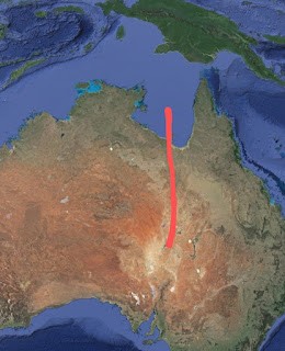
Portions of the Great Artesian Basin are below sea level, which immediately makes it appear as one of these zones of emergence, since the Dead Sea and California's Death Valley are also on lines of emergence.
Furthermore, there are low and short ranges of mountains around the Great Artesian Basin which are otherwise difficult to explain, such as the Grey Range-Barrier Range as well as the higher Flinders Range north of Adelaide. The Flinders range is a range dividing two lines of emergence, with the vast lowland area of New South Wales being the zone to the east of the Great Artesian Basin. The dark line is the Flinders Range.

This "new" basin in New South Wales formed as the land moved tectonically eastward over the north-south line of emergence that connected to the "Great Valley Of Asia", to the north. This entire arrangement of emergence lines resembles that of the Mid-Atlantic Ridge on the other side of the world. The Flinders Range formed when magma from the old and new emergence basins went up against each other, in a way similar to that of the Sierra Nevada and Cascades in the U.S. west.
The emergence from the "new" basin, the one in New South Wales, can be seen to have "broken" the Great Dividing Range, which was an impact line from a Continental Asteroid. There is no other way to explain why it would appear "broken" in this way.
Spencer Gulf, west of Adelaide, forms a straight line with Lake Torrens and Lake Eyre North, which would have been along the line of emergence represented by the Great Artesian Basin. Yorke Peninsula, separating Spencer Gulf from the Gulf of St. Vincent, appears to be a geological extension of the Flinders range.
You can see that, in so many ways, the Great Artesian Basin of Australia resembles the Great Basin of the American west, which we know is the result of lines of emergence. Also notice how the lowland of New South Wales resembles the lowland basin with mountains around it of southeastern Europe. I would definitely say that this represents the earth's former equator as it extended south of the present equator.
21) EUROPE AND SIBERIA
In southeastern Europe lies what is one of the most prominent focal points of emergence lines anywhere in the world. Hungary, Croatia and, northern Serbia make up the low area of the focal point. Low ranges of emergence mountains formed between the tangle of lines.
How else could the Carpathian Mountains and the Sudeten Mountains, which form the border between Germany and the Czech Republic, form? The Carpathians, in particular, have a highly-unusual form for a range of mountains. On the map, they resemble a curved upside-down question mark, visible in dark green.
Inside the outside lower curved part of the question mark formed by the Carpathians, southern Romania and northern Bulgaria, is the western end of an emergence line which forms the northern side of the Black Sea. This is the same line that bent northward to form the Sea of Azov, in Ukraine, and through the Volga Valley.
There could be a tectonic collision factor involved in the Carpathians also, since there is some oil in Romania. How could we account for this collision? The comet impact that we will see formed Italy and broke off a section of the Original Impact Line upon which it landed. The red line in the following image is a portion of the Original Impact Line that was diverted northward by the comet impact that formed Italy. The purple dot is the Carpathian Basin. The dislodgement of part of the Original Impact Line over it caused a secondary basin to emerge to the north of the Carpathian Basin. This is the Sudeten Basin and the low emergence mountains around it form the border between Czechia and Germany.

The Sea of Marmara, marked by the red dot in the following image, seems to represent a southeastward line of emergence, joining one across the southern portion of the Black Sea that also forms the east-west valley through Bulgaria. Fildiz Daklari is a typical short range of low emergence mountains.

The lowland gap between the two mountain ranges in Bulgaria is a line of magma emergence that continues southward to form the Sea of Marmara.

Considering the Adriatic Sea between the Italian Peninsula and Croatia, why would there be such a broad strip of low ground, which joins the Po Valley across northern Italy, and which runs between between the two parallel ranges of mountains, of which one is of volcanic origin and the other isn't? This makes the Adriatic similar in this respect to the Persian Gulf, which we know is certainly a line of emergence, and the Adriatic Sea points directly toward what we know is the former south pole as the undersea ridge structure around Madagascar, making it clear that it was once a longitudinal line of emergence.

Also interesting that if we follow the Gulf of Suez, at the northern end of the Red Sea, in a straight line, it seems to continue as the Adriatic Sea. Since the Gulf of Aqaba, on the other side of Sinai, continues as a line of emergence across Israel and beyond, why should not the nearby Gulf of Suez do the same and continue along the line of the Adriatic Sea?
Let's now go to the western Mediterranean area. I am certain that the Po Valley, across northern Italy, is a line of emergence. Notice that to the west, there is a shape outlined by Spain's Balearic Islands that appears to be a continuation of the Po Valley. The mountain range along the north coast of Majorca looks just like typical emergence mountains, and very similar to those in the Crimea which were formed by the emergence line across the northern Black Sea as it bent northward to form the Sea of Azov
If the Po Valley, across northern Italy, was formed by the emergence along a former equator, it would continue to the southwest to form the Balearic Sea.

If we continue further to the southwest along this line, valley in southern Spain which includes Seville and the northwestern lowland of Morocco could possibly be a further continuation. This looks very much like the line of a former equator before the poles shifted because of the impact of a Continental Asteroid.
The valley across the south of Spain, containing Sevilla and Huelva, looks like an emergence line continuation of the former equator line of the Po Valley and Balearic Sea. The perpendicular broad valley, in the northeastern part of Spain containing the city of Zaragoza, would then be a former longitudinal line of emergence.
If this is a continuation of the Po Valley as a line of emergence, then it would explain the wide northwest-southeast valley across northeastern Spain, with mountains on either side, which hosts the city of Zaragoza. if we continue this Zaragoza Valley to the northwest, we see that it continues as a ridge across the ocean floor of the West European Basin until it joins the Mid-Atlantic Ridge.
There are two major roughly southwest to northeast valleys across southwestern Spain, the southernmost one hosting the famous city of Seville. South of these lie the parallel lowland coastal area of Morocco. If we look on a map of the ocean floor, we see that these parallel stretches of lowland continue offshore as undersea ridges. This makes it clear that we can classify them as lines of emergence, specifically the remnants of a shifting former equator.
22) THE BLACK SEA AND EASTWARD
The Black Sea is formed of two roughly parallel lines of emergence that appear very much like former equators. The reason for this is that the two lines were displaced northward by the Original Impact Line, which greatly hinders magma emergence. The line which begins in Bulgaria, along an east-west axis and bordered by low mountains, extends eastward across the southern portion of the Black Sea. This starts out as parallel to the line which we saw bends northward from the Black Sea across Russia, and on to Siberia. The Balkan Mountains of Bulgaria form a dividing line on land between these two lines of emergence, which together form the Black Sea.
The line from Bulgaria, across the southern Black Sea, continues through Georgia (the former Soviet republic, not the U.S. state), Armenia and Azerbaijan. It forms the deep southern portion of the Caspian Sea, and ultimately forms the east-west valley in the far north of Afghanistan.
The deeper southern portion of the Black Sea is formed of a line of emergence that runs parallel to the Turkish coast, and continues eastward from the sea to form the V-shaped lowland that can be seen at the eastern end of the sea, in Georgia, between two sets of mountains and marked by the red dot.

At the western end of the Black Sea, the same line of emergence continues to form the east-west valley through the center of this map of Bulgaria. The parallel line of emergence, which forms the western part of the northern Black Sea, continues westward to form the curve in the Carpathian Mountains, the southern part of this curve can be seen just north of the valley in the map.
It is possible that the so-called Caspian Depression, to the north of the Caspian Sea, could be the result of lying between these two lines of emergence. This would be similar to the low area of the Great Basin in the western U.S. lying within the rough C-shape of the line of emergence which we saw there.
I) OTHER LINES OF EMERGENCE
BRITAIN AND NORTHWESTERN EUROPE
There are other lines of emergence, which explain many landscape features but which are not as directly connected to the impacts of the Continental Asteroids and the shift of the earth's poles and equator.
23) THE PENNINES AND BRITAIN
One geological mystery is how England's Pennine Mountains formed. These mountains form a roughly north-south line along the length of the northern part of the country. How can we explain the puzzling configuration of the Welsh Mountains seeming to be a southward continuation of the Pennines, but being some distance to the west, can be easily explained by having been pushed there by the long-ago tectonic collision of Italy with southern Europe which formed the Alps.
But that still does not explain how the Pennines and the Welsh Mountains formed in the first place. These mountains are not volcanic in nature, nor do they seem to be the result of tectonic collision since the primary direction of continental drift was northward and these mountains are aligned north to south.
I once thought that the Pennines might once have been a part of the Mid-Atlantic Ridge, since the straight line north-south portion of the ridge in the south Atlantic Ocean forms a straight line with the Pennines if we continue the line far to the north. In fact the Ural Mountains, which run north-south across Russia, are just as mysterious as the Pennines and also form a straight line with the north-south section of the eastward continuation of the Mid-Atlantic Ridge which extends northward toward the Red Sea.
But when I had developed this Lines Of Emergence Hypothesis, the solution to the formation of both of these ranges of mountains became very clear. These are north-south longitudinal lines of emergence from the present polar era. We saw that the continents, gradually shifting by tectonic drift, move over these lines of emergence. If the line of emergence is still active, the magma will spread the land of the continent apart as it spreads along the former sea floor, and the result will be a broad valley and possibly a range of the low "emergence mountains" that tend to form along the edge of the line.
But if the line of emergence has become inactive when the continent moves over, it will force the land of the continent upward over the ridge because the solidified magma will act as a ramp. The result will be a range of mountains on the continent above the line.
If we look at a physical geography map showing the ocean floor, we see that there is an undersea ridge running north-south in the south Atlantic Ocean. This line is active today, as a section of the Mid-Atlantic Ridge, and if extended northward leads directly toward Britain. When the continent moved over this ridge, before it's northern sections shifted westward, it forced the land upward and the result is the Pennines and Welsh Mountains of today. Part of the line broke away when Italy collided with southern Europe, and this is why the Welsh Mountains appear to be a continuation of the Pennines but are positioned some distance to the west.
This map shows the Pennines with the Welsh, or Cambrian, Mountains which were pushed westward from the Pennines, to the lower left.

Notice that if we follow the line through the Pennines and continue southward, we arrive at the French peninsula where Cherbourg is located, the Cotentin Peninsula.
It is very probable that this underlying ridge was indeed the original line of what is now the Mid-Atlantic Ridge. There are other ridges to the west, on the floor of the Atlantic Ocean, that could have been subsequent versions of the Mid-Atlantic Ridge as it shifted westward, due to the nearby tectonic movement of the Eurasian land mass, to where it is now.
All of northwestern Europe was once land. The shallow seas such as the North, Baltic and, Irish Seas were carved away to below sea level by moving glaciers, driven by the centrifugal force of the earth's rotation, during the ice ages. The reason that Britain remains dry land is obvious, it was shielded by not only the Pennines and Welsh Mountains but also those of Scotland.
There is one point, to the north of Britain, where this undersea ridge pokes above the water level. Denmark's Faroe Islands are composed of the magma from this ridge, which has long since solidified. The difference between Britain and these islands is that there is a continental land mass which covered the ridge to form the Pennines, but I looked around the Faroe Islands on Google Street View and this is what it looks like without the continent covering it.
Notice that the Faroe Islands are in the form of a "T". The vertical portion of the T is the same line as the Pennines. The top, horizontal, portion of the T can be seen to form a perfectly strait line with the elongated lake and inlet in Labrador, known as Lake Melville, and the northern section of Lake Superior. This line points directly to the Great Basin of the western U.S., which was the second north pole. This seems to make it clear that the line which forms the top of the T on the Faroe Islands was once a longitudinal line of magma emergence from when the north pole was at the Great Basin.
Remember that lines of emergence tend to become permanent features of the earth's geography when they begin in polar era, and are "reactivated" as something else in a successive polar era.
The Faroe Islands, to the north of Britain, form a "T" shape, with the north-south line being in line with the Pennines, and the east-west line being in line with a former longitudinal line of emergence across North America.
No land on this earth is as geologically confusing as Britain. It looks, on a physical geography map, like a jumble of geological pieces that do not quite fit together, and that is just about what it is. The southern portion of Britain is the result of a section of the north-south chain of the Pennine Mountains being displaced to the west by the tectonic collision of Italy, pushed by Africa, with Europe. The displaced section is the Welsh or Cambrian Mountains, since Cambria is the old name for Wales.
The same pattern can be seen in continental Europe. The broad Rhone and Rhine Valleys seem as if they might have once been a continuous line, but the Rhone Valley has been shifted westward in the same way and for the same distance as the Cambrian Mountains. The Rhone and Rhine are valleys, rather then mountains, because they were still an active longitudinal line of emergence when the land of western Europe moved tectonically over it.
On continental Europe, the Rhine River, in the north, and the Rhone River, to the south, appear to be in broad valleys that were once one valley, until the southern part was pushed westward in the same way as the Welsh (Cambrian) Mountains being pushed westward from the Pennines.
24) PIECES OF THE ORIGINAL IMPACT LINE
I arrived at an understanding of the "Original Impact Line". This is the long line of otherwise unexplained mountains and high plateaus extending across the eastern hemisphere from Greece and the Balkans, through Turkey and Iran to the Himalayas and the Tibetan Plateau, and beyond. This, along with Antarctica, is the original rock mass left by the last Continental Asteroid that formed the moon as well and is often referred to by scientists as Theia. My theory is that it also explains the continents, and so much else about the earth, as well as the moon.
My theory of Britain is that the mountains of northern Scotland is actually from a piece of this Original Impact Line that was carried by the tectonic movement of northwestern Europe to the northwest. Land other than this Original Impact Line tends to be either of volcanic or magma emergence origin, or sea floor that has been forced upward by tectonic movement. The story of the northern part of Britain begins when this piece of the Original Impact Line collided with the longitudinal line of emergence represented by the Pennine Mountains. The apparently mysterious straight line across northern Scotland is known as Glen Mor.

My conclusion is that the mountains of Scotland are not related to the Appalachians of North America, as is believed by some, but the rocky mass of most of Newfoundland may be another loose piece of the Original Impact Line that was once part of the same mass as Scotland until separated by the spread of the sea floor caused by magma emerging along the line of the Mid-Atlantic Ridge.
The impact, most likely of one of the comets which provided the water on earth, took place which shattered the western end of the Original Impact Line. Land gradually moved tectonically to the northwest, crossing this line and carrying many of the pieces of the shattered end of the Original Impact Line with it. The westward curve of northern England can be explained simply as being the impact against the line of Scotland to the north.
Scotland was a large piece of the Original Impact Line that split in two upon tectonic impact with the line of emergence represented by the Pennine Mountains. The split can be clearly seen to have been along the straight line of Glen Mor. The northern part of Scotland looks exactly like a mass that has split in two upon impact, along the mysterious straight line of Glen Mor. The southern part of Scotland is a portion of the Pennine line that was knocked horizontal by the impact.
One question that might arise is why western Europe was moving tectonically to the northwest, when we know that the general tectonic movement of continental masses is northward, with the earth's rotation adding it's eastward momentum. But remember the shifting of the poles. The north pole made it's way from the Great Basin of the western U.S., across what is now Hudson Bay and the Foxe Basin, of northern Canada, to it's present position in the Arctic. This means that when the tectonic movement of western Europe to what is now northwest began, it actually was northward.
Lines of magma emergence gradually shift as land moved tectonically over them. The longitudinal line represented by the Pennines curved to the northwest, but it did not shift as fast as the land was moving and what is now the mountains of Scotland being carried along with the land collided with it. Ordinary land can slip over this longitudinal line of emergence, but the mass of the Original Impact Line being carried with it cannot.
When the piece of the Original Impact Line collided tectonically with the longitudinal line, both of them broke into several pieces. The aftermath of this collision explains the puzzle of Britain as we see it today. Scotland is actually three pieces, the east-west southern part of the country, then the northern part split in two, due to collision with the line of the Pennines, along the straight line of Glen Mor.
Just look at the mountains of northern Scotland on the map. Doesn't it look like it was once one piece that was broken in two, along the strait line of Glen Mor?
The north coast along both the Northwest Highlands and the Grampian Mountains both form straight lines that appear to have once been one line until the western portion was pushed to the north as the two sections split along the straight line of Glen Mor.
How else is there to explain this perfect straight line across Scotland other than a split when a piece of the Original Impact Line collided with the Pennines?
The longitudinal line of emergence with which it collided was also broken into three pieces by the collision. One broken off segment of the longitudinal line was driven southward and ended up by the eastern side of the Pennines to form the Cumbrian Mountains of northeastern England, where the fabled Lake District is located.
There is a broad valley between the two mountain ranges, known as Edenside. This valley formed because the approach of one section of mountains to the other forced land between them upward so that the two sections could not actually come into contact, but left the valley between them. This broken section represented by the Cumbrian Mountains actually seems to extend as far south as Manchester.
The Cumbrian (not Cambrian) Mountains are a section of the Pennines that were broken off by the collision of a part of the Original Impact Line, and the lakes that it encloses forms northern England's picturesque Lake District.


This is what the Original Impact Line looks like. Mountains that are neither of volcanic origin nor were formed by tectonic collision. They came from the Continental Asteroids. The Original Impact Line extends from Greece and Turkey through Iran to the highlands of central Asia, including the Himalayas. The Himalayas were formed by the collision of India with Asia, but it must have been high and rocky ground already for the Himalayas to be so high.
The mountains on the eastern side of the Adriatic Sea are aligned northwest to southeast because this is the direction into which the Original Impact Line was forced by the comet impact which created Italy and left the portion of the Original Impact Line west of here as tectonically drifting fragments that we are discussing here.
As far as I can tell, the pieces of the Original Impact Line are all rocky features and islands, all in western Europe, that are difficult to explain any other way. These include the island of Corsica (but not Sardinia, which is volcanic), The Tuscan Archipelago of islands between Corsica and mainland Italy, Malta, possibly part of Pantelleria (although Pantelleria has a volcanic element as well), the Massif Central in southwestern France, Mont St. Michel on the Normandy coast, the North York Moors in northern England (which almost certainly was a piece of Scotland which broke off), southern Ireland (including the parallel peninsulas in the southwest of the island which typically form when a piece of Original Impact Line gets positioned over a line of magma emergence), the high rocky areas of northwestern Ireland in Counties Mayo and Donegal, Switzerland must have been a high and rocky fragment of the Original Impact Line even before Italy collided with it to form the Alps, The mountains of Scandinavia seem certain to have been a dislodged segment of the Original Impact Line resulting from the likely comet impact and finally, the long elongated island in the Russian Arctic to the east of Scandinavia appears very much as a piece of the Original Impact Line which drifted tectonically until coming to rest against the emergence line represented by the Ural Mountains.
Furthermore, if the Massif Central of southern France was another stray piece of the Original Impact Line, the gap between that and the coastal mountains of Croatia is just about perfect for the length of the piece which was to become the mountains of Scotland to be taken from here.
The mountains of southern Ireland seem to be difficult to explain. We can see that the mountains across the northern part of Ireland are a continuation of those in Scotland, but what could have produced the mountains in the south? Across southern Ireland are low mountains, valleys, lakes, peninsulas and, bays that are aligned in parallel from east north east to west south west.
These mountains are too high to be of glacial origin, but too low to be the result of a tectonic collision. This includes the Wicklow Mountains, to the south of Dublin, which is not parallel to the others because these are a part of the curve of the emergence line rather than of the "shortcut" lines across the curve. From these mountains and valleys come some of the most famous of Irish county names such as Kilkenny, Kerry, Tipparary and, Cork.
Fortunately, this hypothesis provides a simple explanation. The north-south peninsula on the north coast of France, hosting the city of Cherbourg, is a straight line continuation of the line of the Pennines In England, to the north, remembering that the Welsh (Cambrian) Mountains were once a part of this line that were broken off and pushed westward by later tectonic movement when Italy collided with Europe, and also formed the Alps. There is still a long gap in the line, where the English Channel is now located.
The Valley of Jezreel is the famed place where Gideon did battle with the Midianites, and Saul with the Philistines. The Book of Revelation, Chapter 16, tells us that Armageddon is actually a place and it is this valley. The valley is not otherwise mentioned in the New Testament, but Jesus must have crossed it because Nazareth is north of the valley.
Another, smaller, valley doubles back to the Jordan Valley from the Jezreel Valley, meeting the Jordan Valley at the Sea of Galilee, which is likely what caused the sea to form. The high ground in the middle is an extension of the Judean Highlands, and is centered on Mount Tabor.
Look at how smooth is the coast of Israel on a map. There are no inlets at all from Haifa going southward well into the Sinai Peninsula, it forms a neat curve. This can be easily explained by the underlying foundation of the land being the solidified magma which long ago emerged from the nearby line of emergence, which now forms the Jordan Valley.
J) THE FIRST SET OF POLES
When I completed the theory about the lines of magma emergence across the world, and how the earth must have shifted on it's axis from it's original poles and equator to re-balance the planet's rotation because of the added mass of a Continental Asteroid, which collided with the earth, I was hoping that it would explain all of the major features that we see on the earth.
While it did go a long way toward a full explanation of the earth's surface, as we see it today, a lot remained which simply did not fit into the theory. It was the floor of the Pacific Ocean that was the most baffling. One thing that had long puzzled me is the angle between two straight lines of mountains on the floor of the Pacific that is seen just west of Midway Island. There is an angle of about 120 degrees between the two lines that was very difficult to explain.
Let's review the basics of this theory about lines of magma emergence and the Continental Asteroids. When the earth is spinning, the centrifugal force brings magma (molten rock) from below to the surface along periodic longitudinal lines which run from pole to pole. There also tends to be magma emergence along the equator. A large rocky asteroid, named Theia by some, is believed to have collided with earth and much of the debris hurtled back into space where it coalesced by gravity in earth orbit to form the moon. My theory is that the portion which remained on the surface of the earth also explains the continents.
The added mass that was "splattered" across the earth's surface from the Continental Asteroids unbalanced the earth's rotation. This caused the earth to shift on it's axis so that one of the poles was within the bulk of the new mass, to re-balance the rotation. This is why the present south pole is in Antarctica. But the former lines of emergence from before the shift can still be seen in how it has affected the terrain above it, whether land or sea floor. When a line of emergence is on the sea floor, it shows as a ridge or chain of mountains. When a line is under the land, it often shows as a broad valley because the emerging magma spreads the land apart.
I have found that there were actually three Continental Asteroids, and two corresponding shifts in the poles and equator. The poles and equator that we have today are the third set of poles and equator. The previous set of poles that were described in the theory, the former north pole at the Great Basin of the western U.S. and the former south pole as the undersea ridge structure now seen around the island of Madagascar, diametrically opposite the Great Basin. This ridge structure around Madagascar is very similar to that seen on the floor of the Arctic Ocean, around the north pole, and is formed because the pole is where the longitudinal lines of emergence converge.
Remember that emergence activity continues along lines of emergence long after the shift of the poles. There is more emergence to be expected where lines intersect at sea, and this is where we often find islands. Lines of magma emergence tend to form ridges on the seafloor, but broad valleys on land.
34) THE THREE CONTINENTAL ASTEROIDS
The first two Continental Asteroids seems to have been smaller than the second, and to have impacted the earth at a higher angle. The Original Impact Line that I identified as coming from a Continental Asteroid were almost certainly from the third and largest Continental Asteroid.
Part of the lands across the world that seem to have come directly from a Continental Asteroid are different in nature from others. The Original Impact Line; Antarctica, the site of impact, and the long line of mountains through the Balkans and Greece through Turkey, Iran and central Asia and beyond, and also including the mountains of Scandinavia, which were broken off and pushed northward by later tectonic activity, are likely from the impact of the Third Continental Asteroid as it slid across the earth due to it's low angle of impact. This also includes fragments in the area of Europe, such as likely Corsica, Scotland, the Massif Central of France, and possibly Spain.
These areas, with the exception of the high plateau of central Asia, tend to be sharply mountainous due to the angle of impact of the Third Continental Asteroid, which must have impacted the earth at a relatively low angle.
Other areas that also appear to be of the same origin are high in elevation, but nowhere near as mountainous. These include southern Africa, Australia, eastern Brazil, the West African Craton and the Arabian-Nubian Shield. The rest of the land on earth is either seafloor that was forced upward by tectonic movement of this land mass, or lands created volcanically by magma emergence.
This concept of three Continental Asteroids, and three resulting initial land masses, fits well with what we know of past tectonic collisions between land masses. There have been mountain ranges produced by land masses moving tectonically and colliding with tectonic plate boundaries, including the Rockies and Andes as well as the mountains of Papua New Guinea. But probably all major tectonic collisions between land masses; India with Asia, Africa with Europe and western Asia and, the sliding collision between what is now Africa and what is now North America to form the Appalachians, have all been between land masses from different Continental Asteroids.
35) THE FIRST NORTH POLE
Before the continental mass was deposited on earth by the two Continental Asteroids, there was still the tectonic plates which formed as the early earth cooled and the surface contracted. We can logically expect that the poles, seeking to best balance the earth's rotation, would have the heaviest surface mass on earth at one of the poles. This would be the Pacific Plate, the pole was near the center of the Pacific Plate but weighted in the direction of the adjoining second largest plate, the Eurasian Plate.
In fact, all major mountain ranges formed by the tectonic collision of land masses with plate boundaries; the Rockies, Andes and, the mountains of Papua New Guinea, were formed by collisions with the Pacific Plate. The Pacific Plate is irregularly shaped but we can see that the first north pole, before the one at the Great Basin in the western U.S., as near the middle of the largest part of the Pacific Plate. There would be no emergence before the formation of the tectonic plates because the entire earth was hot and molten.
Hawaii was formed by a lot of magma emergence, and it just happens to be exactly in the center of the largest tectonic plate on earth, the Pacific Plate. That is because one of the poles had to be located there, in order to balance the earth's rotation. The magma emergence at a pole is because the longitudinal lines of emergence, which have to perpendicularly balance the equatorial emergence from the earth's spin, would come together there. The corresponding south pole would be the Kalahari Basin, in southern Africa. The basin is because the magma emergence that would have occurred there tends to spread land apart, thus creating a basin.
35b) THE SECOND NORTH POLE
We can see that there is a complex of undersea ridges around the present north pole, formed by the convergence of longitudinal emergence lines at the pole, and a similar type of structure from the former south pole in the south Atlantic Ocean, the semi-circular undersea ridge structure at the "bend" in the Mid-Atlantic Ridge. We should thus expect to see some type of structure remaining if the second north pole was indeed in what is now the western Pacific Ocean.
Look at the lines of the undersea mountain ranges (undersea mountains are known as seamounts) west of Midway Island. There are two straight lines meeting at an angle of about 120 degrees. This is the area of the first north pole. Notice that, on the opposite side of a flat area, there is a matching angle of about 120 degrees in two undersea mountain chains. This does not involve the complex structures to the south and west, which are plate boundaries. This was the second north pole, where it moved from Hawaii to balance the weight of the First Continental Asteroid, which landed in the south Atlantic and the corresponding south pole migrated to the center of it's mass.
Notice that most of the long lines of island and mountain chains in the Pacific Ocean seem to point toward this area west of Midway, and there is the structure of undersea ridges to be seen here that we would expect to find at a former or present pole on a sea floor. The undersea ridge that pokes above the water to form the island of Kiribati points toward the area of the first north pole, west of Midway. The so-called Christmas Ridge, upon which the U.S. military island of Johnston Atoll lies, also points directly at this pole.
By the way, there are two basic types of Pacific island. Islands with mountains or high ground are from where volcanoes have broken the surface of the water. Flat coral atolls are from where there is an extinct volcano below the surface of the water upon which coral builds up on over millions of years. The lagoon around which a coral atoll is structured is over the former opening of the volcano.
Hawaii is right in the center of the largest section of the Pacific Plate. Mauna Kea and Mauna Loa are actually the highest mountain, if the undersea portion is included, and the largest volcano in the world. This shows the special nature of the Pacific Plate, the thickest and largest of the plates. It is too thick to have the lines of emergence found elsewhere, but pressure from rising magma has to break through somewhere and it is logical that this be at the very center.
But Hawaii is not just the "hot spot" that it is sometimes referred to as. Hawaii is actually a part of a very long line of seamounts that leads right to the area, just west of Midway, that is the former north pole. It is known as the Hawaiian-Emperor Seamount Chain.
Amazingly, Hawaii actually has a lot in common with Cuba. Just as the Cuba-Phoenix Line is, as we have seen, a former longitudinal line of emergence that can still be seen between the former poles, the former north pole of the Great Basin in the western U.S. and the former south pole as the undersea ridge structure around Madagascar, which is the third south pole, the next one, Hawaii is on a former line of emergence directly between the former north pole west of Midway and the former south pole on the opposite side of the world in the south Atlantic.
The line that joins the Hawaiian-Emperor Seamount Chain at the former north pole west of Midway runs northward from there to the third and present north pole, through the far east of Siberia. You can see how both of the semi-circular undersea ridges on either side of the second north pole, west of Midway, have extensions which point directly toward the third north pole, at the Great Basin of the western U.S.
36) THE SECOND SOUTH POLE
If you look closely at the satellite imagery, or a detailed undersea map, you can see that there is a line of seamounts across the Atlantic Ocean off the coast of Brazil that is directly in a line with the Hawaiian-Emperor Seamount Chain. This line also includes the undersea Bromley Plateau.
The Bromley Plateau, and line of undersea mountains, are just off Sao Paulo and aligned in a line with the long line of seamounts that lead to Hawaii.

The line of Hawaii from the second north pole thus shows off the coast of Brazil in the same way as does the island of Barbados off the Caribbean Plate boundary along the Cuba-Phoenix Line, that we have seen previously. There is a ridge off Brazil where this line from Hawaii meets the Mid-Atlantic Ridge. There is also a broad bay, off Sao Paulo, along the Hawaii Line, as we will call it. This is caused by emergence spreading the land apart. We see more evidence of the intersection of this Hawaiian former longitudinal line of emergence with South America in the supporting document, "The Extrusion Mountains of South America".
The second south pole is the undersea ridge structure in the south Atlantic Ocean where the Mid-Atlantic Ridge curves around southern Africa
This undersea ridge structure was the second south pole, before it migrated to the undersea ridge structure around Madagascar, the third south pole, due to the unbalancing mass of the impact of another Continental Asteroid.
The south Atlantic north-south section of the Mid-Atlantic Ridge seems certain to have originated as a longitudinal line of emergence linking the second and fourth (present) south poles. In a similar way in that, as we have seen, the section of the "W-Line" of magma emergence that extends around the world, of which the Mid-Atlantic Ridge is a part, is the line linking the present poles through the former (third) south pole near Madagascar, this section of the Mid-Atlantic Ridge is between the present poles through the second south pole, in the south Atlantic. The W-Line is in blue. The portion on the left is the Mid-Atlantic Ridge. A section that extends northward into the Indian Ocean gives it a vague W shape. The portion on the right forms the Gulf of California and Central Valley.
The Walvis Line, the east-west section of the Great Rift Valley across southern Africa continuing offshore as the Walvis Ridge from the area of the border between Namibia and Angola, is a line of emergence linking the second and third south poles. There is an east-west line of seamounts off the coast of Brazil pointing directly at the beginning point of the Walvis Ridge, on the other side of the ocean, but the southwest-northeast line of the Walvis Ridge points directly to, and along, the Indus Valley of Pakistan and the undersea ridge in the Arabian Sea preceding it. This is a former longitudinal line of emergence from the days of the second south pole, in the south Atlantic Ocean. This long line continues to, and along, the vast and elongated Lake Baikal in southern Siberia.
This is the Walvis Ridge, the very long undersea ridge that extends out to sea from around the border of Angola and Namibia. It is the way by which the south pole migrated toward the next south pole, at the undersea ridge structure around Madagascar.
Keep in mind that the seafloors of the Atlantic and Indian Oceans have been spreading, unlike the Pacific, and this may somewhat distort some of the locations of very old features. We can say that at first it was the north pole that determined the locations of the poles, with the north pole centralized on the Pacific Plate, but after the introduction of the Continental Asteroids and their land masses, it was the south pole that determined the locations by positioning within this new mass.
Between Antarctica and South Africa, we can see that there are two lines of seamounts from the first south pole to the future south pole as it transitioned from the second, near Madagascar, to the third and present south pole. The northernmost of these lines pokes above the water to form a few small islands, including Ile Aux Cochons and Ile de la Possession, and also the French Antarctic Territories.
Off Antarctica, in the satellite imagery, can be seen three undersea ridges extending toward South Africa and Madagascar. These are also likely lines of emergence from the present to the former south pole as it transitioned from first to second south pole.
Notice also that the ridge that extends from the southwestern corner of Australia to the north-south running Ninety East Ridge, which is a line of emergence between the two present poles, points directly toward the second south pole, which we know was near Madagascar.
There is a very pronounced undersea ridge extending from the southwest corner of Australia to the north-south Ninety East Ridge.

There is also the easily visible long undersea ridge extending between the last and present south poles. The fourth south pole is, of course, the present one in Antarctica. This ridge pokes above the surface to form the French Southern And Antarctic Lands.
37) THE SECOND EQUATOR
If there was a previous set of poles, then there must have been a previous equator to match. The second equator is clearly seen. There is a segment of the W-Line, the present line of emergence extending around the world, that gives it the W-form as the middle element. This line extends from the third south pole, adjacent to Madagascar, northward toward the Red Sea which is also a line of emergence. North of the ridge structure around Madagascar, this line bends at an angle of about 120 degrees toward the Red Sea.
Notice that this section that bends forms a line with a ridge off the northwestern corner of Australia. If you consider this line relative to the first north and the first south pole, it becomes clear that this is the remnants of the second equator. This line actually continues to the other side of the world, as the broad valley hosting the Spanish city of Zaragoza and then as a section of the Mid-Atlantic Ridge and the branch of the Mid-Atlantic Ridge between Canada and Greenland and through Baffin Island, although obviously none of this was a part of the second equator. The section across the Atlantic and Spain became a longitudinal line when the north pole was transitioning from third to fourth north pole. Remember that lines of emergence continue as active for a long time after the poles shift, and always try to form straight lines.
This undersea ridge off the northwestern corner of Australia is positioned just right to have been formed by magma emergence along a former equator, when the south pole was in the south Atlantic Ocean, as described above.

Remember that we can expect more magma emergence when two lines meet on the seafloor. The first equator is seen at the intersection with the Ninety East Ridge as a large seamount attached to the west side of the ridge and as the British Indian Ocean Territory, including the atoll of Diego Garcia, at the intersection with the Chagos Laccadive Ridge, which runs parallel to the Ninety East Ridge to the west of it.
The island of Socotra is on the former equator, not far east of the entrance to the Red Sea, which is as we have seen previously a longitudinal line of emergence off the second south pole, the one near Madagascar. The only reason that it is not exactly at Madagascar is that the seafloor has spread along the W-Line.
The Galapagos Islands are where the second and fourth (present) equators and the Hawaiian former longitudinal line all meet. Remember that we can expect more magma emergence at such intersections. There is a ridge from the coast of Ecuador to the islands along the present equator. The second equator in this area also corresponds to a plate boundary between the Cocos and Nazca Plates, and can be seen in the satellite imagery as the line from the Galapagos Islands to the border between Panama and Costa Rica.
The Galapagos Islands is where the present equator meets a previous equator. The ridges from emergence caused by both equators can be clearly seen on the seafloor, and meeting at the Galapagos Islands.

38) CLOSING OF THIS SECTION
This is all about the ocean floor, and why islands appear where they do. How, aside from tectonic plate boundaries, can lines of islands and seamounts be explained? Detailed maps of the ocean floor have been available only relatively recently and there are many patterns that have not yet been noticed.
This scenario of the first poles would put the north pole very near the center of the largest part of the largest plate. But when the first, and then the second, Continental Asteroids added their mass to the earth's surface, the south pole moved into the new mass to best re-balance the earth's rotation and the north pole also had to move. Considering this scenario, and the basic rules of emergence, I think that it now leaves very little that is not explained by this theory.
K) THE FIRST ANTARCTICA AND THE FIRST ORIGINAL IMPACT LINES
If Antarctica and the Original Impact Line came from the Third Continental Asteroid, what happened to the original land mass of the First and Second Continental Asteroids? If it was massive enough to cause the earth's axis to shift, it's mass must be visible somewhere on earth. If the "First Antarctica" was at the second or third south poles, where could it be now? I believe the First and Second Continental Asteroids to have been somewhat smaller than the third, and to have impacted the earth at a higher angle. But if the Third Continental Asteroid left what I refer to as the "Original Impact Line", wouldn't it make sense that the First and Second Continental Asteroid before it would have also left some such line of high and otherwise unexplained mountains?
It does, and I will refer to it as the "First Original Impact Lines" of the First and Second Continental Asteroid.
Most land is today in the northern hemisphere because it broke away by volcanic activity beneath and the centrifugal force of the earth's rotation, and drifted away tectonically. A similar process took place with the First and Second Continental Asteroids, but was interrupted by the shift in the axis of the planet caused by the landing of the Third Continental Asteroid, before the process got as far as that with the Third Continental Asteroid today.
There is no "Antarctica" remaining at the second or third south pole because the pull toward the equator due to the earth's spin, volcanic activity underneath and, the Third Continental Asteroid and the breaking away of land from the present Antarctica broke it up. But the undersea ridge structure from the convergence of longitudinal lines of magma emergence at the second and third poles, the circular ridge structure in the south Atlantic and the Mascarene Ridge around Madagascar, does remain.
I find that several major sections of land broke away from this "first two Antarcticas", and drifted away what was then north. These sections are what we see today as Australia, the Arabian-Nubian Shield, the West African Craton and the smaller cratons making up southern Africa and possibly, Spain.
There was likely another large mass of land, which broke off by the centrifugal force of the earth's rotation and volcanic activity and drifted what was then north, but then when the Third Continental Asteroid landed, that land was moving in the wrong direction. It's direction of movement changed, over millions of years, until it collided with the "First Original Impact Line" of the First Continental Asteroid. It continued on, after undergoing a sliding tectonic collision and finally leaving much of it'a mass behind. It next collided with the ridge structure which had been at the south pole from whence the moving mass of land had originated.
The place where the First Continental Asteroid landed was, of course, what would become the second south pole as the earth shifted on it's axis to accommodate the new mass by getting one of the poles centered in it. This likely large land mass that I referring to broke away and drifted tectonically to what was then north but is now southwest. The mass shifted back into the original direction when the dynamics of rotation changed again after the Third Continental Asteroid landed. The land mass then underwent a sliding collision with what is now the southern portion of the First Original Impact Line.
This is what probably formed the Witwatersrand (White Waters Ridge) in South Africa, and quite a bit of the land mass was left behind here. The rest of the land mass eventually collided with the ridge structure which had formed from the longitudinal lines of emergence which had converged at the second south pole which had centered on the mass of the First Continental Asteroid. This land is what we see today as Madagascar, which is not volcanic in origin even though it lies against the undersea ridge structure of lines from magma emergence.
How did the extensive line of mountains in southern and eastern Africa originate? These mountains are not the result of a tectonic collision, they are nowhere near a plate boundary, and are not volcanic in nature other than Kilimanjaro, which we will see in the section in the Supporting Documents "The Mystery Of Mount Kilimanjaro". The Great Rift Valley of east Africa runs through these mountains, but that is itself one of these emergence lines from the present polar era and is not a plate boundary.
There is an extensive line of high mountains, running mostly north-south, in east Africa. The southern part of Africa is also high and mountainous.

There are three great lines of mountains in the world. The Rockies and Andes of the western hemisphere are young mountains that were formed by the tectonic collision of North America and South America with the edge of the Pacific Tectonic Plate. Then there is the Original Impact Line that I described in this geological theory, the line of high and otherwise difficult to explain mountains extending from Greece and the Balkans, eastward through Turkey and Iran, to the vast area of high terrain of the Central Asian Plateau. These extensive mountains through eastern and southern Africa are the third great line. There are very high mountains in Ethiopia, and the difficult-to-explain mountains extend through east Africa all the way to the opposite end of the continent in South Africa.
As what was then the south pole shifted eastward, after the added mass on earth of the Third Continental Asteroid, it made the "First Original Impact Line" of the First Continental Asteroid further north even if this line did not actually move itself. This caused the centrifugal force of the earth's rotation, which is greatest nearest the equator, to shift the line even further north.
The Original Impact Lines of each of the Continental Asteroids eventually collided. The reason that the third did not land on the first or second by chance is that the Third Continental Asteroid landed somewhat near to what was then the equatorial plane, in accordance with the general orbital plane of the Solar System. The "First Original Impact Line" of the First Continental Asteroid was still at what was then the south pole, now the undersea semi-circular ridge structure in the south Atlantic, where the bend in the Mid-Atlantic Ridge is located. The eventual collision between the two can be seen in how the line of mountains through Iran and Turkey are shifted northward, as we proceed eastward from central Asia. Arabia, centered around the Arabian-Nubian Shield, was also in the collision and so much sandy seafloor was forced upward. Much of north Africa is also land that was forced upward by this collision and this forcing upward of seafloor into dry land also created vast pockets in the rock strata where oil could collect over millions of years.
My belief is that tectonic collisions between land masses tend to be between elements of each of the Continental Asteroids, but this may not always be a strict rule. One such exception is Spain colliding with Europe, to form the Pyrenees, and then Africa colliding with Spain, forcing up the Rock of Gibraltar. Both Africa and Spain are likely from the First Continental Asteroid, and Europe from the third. In any case, there must be such an exception to the rule here because Spain was clearly involved in two separate tectonic collisions.
Notice that this First Original Impact Line of the mountains through Africa is aligned virtually perfectly perpendicular to the Original Impact Line through Asia to Europe. Remember that longitudinal lines of magma emergence form because the equatorial emergence, brought about by the earth's rotation, must be balanced in a perpendicular direction. We also saw how the vast amount of magma emergence along the Mid-Atlantic Ridge serves to balance the mass of the Original Impact Line in a perpendicular direction in the supporting document "The Mid-Atlantic Ridge And The Original Impact Line" Isn't it logical that this First Original Impact Line, from the First Continental Asteroid, also became positioned as it did to physically balance the Third Continental Asteroid's Original Impact Line?
The Original Impact Line stretches across the eastern hemisphere, and is now east-west relative to Antarctica of which it was originally a part. The First Continental Asteroid had it's First Original Impact Line also, although it was a smaller asteroid and the line was not quite as extensive as that of the Third Continental Asteroid. Look at how the north-south line of mountainous east Africa is aligned relative to the Second South Pole, in the south Atlantic. This is the direction that, at the time, was north-south. The then-northward movement of this First Original Impact Line did not go as far as with the Third Continental Asteroid. The high and extensive mountainous terrain of eastern and southern Africa was the First Original Impact Line of the First Continental Asteroid.
But then what of the Second Continental Asteroid, that caused the south pole to move to the center of it's mass at what is now the undersea ridge structure around Madagascar? The mass of that asteroid must have moved away somewhere, but where?
However, if we look to the east, which is to be expected because the eastward momentum of the earth's rotation affects the tectonic movement of land masses, we see that the long lines of the Great Dividing range of Australia, the Southern Alps of New Zealand and, the "spine" of Papua New Guinea look just like the broken apart impact line of a continental asteroid.
L) EMERGENCE CENTERS ACROSS THE WORLD
Here, we have something about the earth that has never been seen before. According to the theory here about lines of magma emergence across the world, there are a number of places where the volume of emergence is much more concentrated then usual, not including tectonic plate boundaries. But the questions arises as to why such centers of concentrated emergence would be found in certain places.
There would logically be greater emergence where equatorial lines and the longitudinal lines which balance them intersect, but this still must follow some kind of pattern. If the arrangement of these centers of concentrated emergence is related to the shifting of the poles that took place to balance the new mass of the Continental Asteroids, then there should be some repetition that would become apparent.
I have decided to use some longer paragraphs than I usually do, in an effort to make this easier to understand.
39) FLUID DYNAMICS AND MAGMA EMERGENCE LINES
Emergence lines are due to centrifugal force. The spin of the earth causes hot and molten rock to emerge from below along the equator. According to the principles of fluid dynamics, this equatorial emergence must then be balanced by emergence along periodic longitudinal lines of emergence across the earth, that would run from the north pole to the south pole.
According to my theory of these emergence lines, the earth's equator has shifted three times due to the landing of Continental Asteroids, which form the stable parts of the continents that we have today. It is not a new idea that a large asteroid once collided with the earth to form the moon, it is commonly referred to as "Theia". My theory has it forming the continents as well, and also that there were actually more than one such asteroid.
The addition of the new mass would have unbalanced the earth's rotation so that the planet would have regained this balance by shifting the closest pole so that it would be in the middle of the new continental mass. Each time, it was the south pole which shifted to the center of the new mass, which is why the south pole is in Antarctica today as it is the location of the Third Continental Asteroid impact.
When each of these two polar shifts took place, the equators and the periodic longitudinal lines of magma emergence which formed to balance the emergence along the equator would also have to have shifted. But the magma emergence in those lines would have continued for a long period of time, as geologic processes change very slowly. In addition the breaking apart of the new continental masses from the asteroids, so that part of the earth's surface was covered by continents, would have also affected the formation and routes of the emergence lines.
These lines of magma emergence, whether equatorial or longitudinal in formation, will tend to show up as long ridges if on the seafloor but as broad valleys or bodies of water if on land because the emerging magma below tends to spread the land apart. A former equator will no longer form a straight line if the earth shifts to a new equator, but the lines of magma emergence "try" to form straight lines due to the force of the earth's rotation.
The emergence along the equatorial zone will naturally be much greater, due to the centrifugal force. But there must, according to the laws of fluid dynamics, be a balance as a longitudinal line not too far away.
The great amount of equatorial emergence in the Caribbean and northern Brazil is balanced by the longitudinal Mid-Atlantic Ridge. The equatorial emergence in the Congo Basin is similarly balanced by the longitudinal Great Rift Valley across east Africa. The great equatorial emergence around Indonesia is balanced by the longitudinal emergence along the Ninety East Ridge, on the floor of the Indian Ocean. These north-south lines of emergence, which balance the equatorial emergence, are in turn balanced themselves by the east-west southern section of the Great Rift Valley and the east-west emergence line across the southern Indian Ocean which was the route of the shifting south pole from the second to the third polar eras.
The important thing is that emergence along equatorial and longitudinal lines must ultimately be balanced.
The mostly east-west migration of the south pole from the south Atlantic to Madagascar before migrating to it's present location in Antarctica, due to the the impact of the Third Continental Asteroid, left a trail of emergence as the Walvis Ridge on the south Atlantic seafloor and the southernmost east-west section of the Great Rift Valley in southern Africa. This is another reason why the north-south section of the Great Rift Valley in east Africa formed, to balance it as a longitudinal line of emergence, and this is part of the reason that there are several prominent north-south longitudinal lines of emergence in the Indian Ocean.
Longitudinal lines of emergence do not absolutely have to be evenly spaced to balance the magma emergence along the equator, but they would have been during the era of the first poles before there was any land. In that early earth, before there were any continents, there would be no reason for the periodic longitudinal lines of emergence, which formed to balance the perpendicular emergence along the equator, not to be evenly spaced.
Even with all of the interfering land on earth today, we can still see the roughly even spacing of the longitudinal lines of emergence in the southern hemisphere, where there is much less land than in the northern hemisphere. The Chagos Laccadive Ridge, a major undersea ridge running north-south on the floor of the Indian Ocean, is 90 degrees from the southern section of the Mid-Atlantic Ridge. Halfway between the two ridges is the Great Rift Valley, which runs roughly north-south across east Africa. Some distance to the east of the Chagos Laccadive Ridge is the north-south Ninety East Ridge, with it's northern end forming the lowland of Bangladesh. The lines skip the Pacific Tectonic Plate because there is the least linear emergence there, due to the thicker nature of the plate, although there are many volcanic islands where the emergence has broken through.
40) THE CENTERS OF MAGMA EMERGENCE ACROSS THE WORLD
A legacy of the first equator before there were any continents is the even spacing of the periodic longitudinal lines of emergence. I was amazed to find a way that we can still see this on the earth of today.
Longitudinal lines of emergence before the landing of the Continental Asteroids were evenly spaced, there was no reason for uneven spacing. Semi-even spacing can still be seen in the watery southern hemisphere in the southern portion of the Mid-Atlantic Ridge, the Chagos Laccadive Ridge and, the Ninety East Ridge.
When the poles shift, previous lines of emergence, whether equatorial or polar, may be reactivated because magma emergence from below was already in place there. The previous equators could not be maintained as emergence lines due to the change on the earth's rotation. But emergence would continue along those lines for a long time.
New lines of emergence which would form after a polar shift will cross the former equator and are likely to incorporate or pass near the former intersections between the former equator and longitudinal lines of emergence, where there would be some emergence activity remaining, to incorporate the existing emergence from a previous era into a new line.
I would like to point out how a line of magma emergence centers across the world, actually two straight lines on a map that join to one another, are the legacy of the previous equators. The centers of magma emergence that make up these lines are former intersections of longitudinal emergence lines with the former equators that tended to be active in all four polar eras, which includes the present one.
The lines are the ghost of the first two equators, but equatorial emergence had to be balanced by longitudinal emergence, in accordance with the rules of fluid dynamics, so we would expect that both dimensions would have an equal presence in the emergence centers. Indeed, some of the centers are dominated by equatorial emergence and others by longitudinal emergence. But also that the two types of emergence centers would ultimately be of the same number, since the very purpose of longitudinal emergence lines is to equally balance equatorial emergence.
I count twelve emergence centers altogether, with eight on the two straight lines that I referred to. The eight emergence centers on the straight lines are evenly divided between centers dominated by equatorial emergence, and those dominated by longitudinal emergence. The four emergence centers that are not on the two straight lines are also evenly divided between those dominated by equatorial emergence and those dominated by longitudinal emergence. In fact, the four centers that are not on the two straight lines exist as two pairs, one pair of centers dominated by equatorial emergence and one dominated by longitudinal emergence. But there are no centers based on equatorial emergence either in the far north or the far south, away from the three equators that the earth has seen.
One of the straight lines we will call the Eurasian Line, because it crosses Europe and Asia. The adjoining line we will call the Pacific Line, because it crosses the Pacific Ocean and North America.
Within most of the twelve emergence centers is a clearly visible line that is aligned at a certain angle. With the emergence centers on land, this line is often seen as an elongated lake. What is so interesting is that the Angle of Elongation is roughly equal to it's latitude.

The reason for the line of strongest emergence within each emergence center is that while all of the centers are the result of intersections between longitudinal lines of emergence with equators, the balance of the two is not equal in any given center of emergence even though it must be equal in all such centers across the earth as a whole.
The reason for this is when the earth shifts because of the landing of a Continental Asteroid, the intersection of equatorial and longitudinal emergence that was at the former equator also shifts position, and this throws off the balance between the two so that either the equatorial or the longitudinal emergence becomes more powerful than the other. Even though the two must balance out across the earth, as a whole. Equatorial emergence is dependent on the centrifugal force of the earth's rotation so that it is stronger than longitudinal emergence near the equator, but weakens faster as it is shifted away from the equator. For every shifted intersection in which equatorial emergence becomes weaker than longitudinal emergence, there is another in which the opposite occurs.
The central zones that are dominated by longitudinal emergence have their lines of strongest emergence aligned mostly north-south but at the same angle relative to present north-south as the Eurasian Line is relative to the present equator. This is, once again, necessary to achieve balance of emergence across the earth as a whole.


In Section C Lake Urmia, indicated by the red dot, is exactly halfway between the Rann Of Kutch and Lake Balaton.


41) EACH OF THE CENTERS OF MAGMA EMERGENCE
Let's start a tour with a list of all twelve emergence centers on earth.
The Eurasian Line:
The circular Bismarck Sea, in the south Pacific just off the island of Papua New Guinea. This is an equatorial emergence center. The Bismarck Sea is a small, nearly circular sea, adjacent to the Pacific Ocean and next to the island of Papua New Guinea, of which the long mountainous peninsula extending to the southeast is a manifestation of magma emergence along the second equator. The so-called Bismarck Archipelago of magma emergence islands that separate the sea from the Pacific consist mainly of the islands New Britain and New Ireland. This sea looks very much like a magma emergence center. Look carefully at the seafloor in the satellite imagery and you will see a nearly flat basin surrounded by seamounts (underwater mountains) in the northern part of the sea right against the islands of the archipelago. There is another line of seamounts outside of the islands creating another basin of the same directional alignment outside of the islands of the archipelago. This is the line of strongest emergence of this center. Notice that the directional alignment of this line of strongest emergence is at almost the same angle as the long mountainous peninsula extending southeast from Papua New Guinea, which was the line of the second equator as we saw in the theory. But it is not quite at exactly the same angle, the elongated basin on the seafloor is actually aligned about halfway between the angle of the long mountainous peninsula and a directly east-west line. That is because the alignment of the basin is a vector between the second equator and the nearby present equator.

One other prominent line of magma emergence from the era of the first set of poles can be seen today as the Indus Valley of Pakistan. Notice that it points directly toward the first south pole in the south Atlantic Ocean. Remember that, even after the poles shift due to the added mass of a Continental Asteroid, emergence along the former equatorial and longitudinal emergence lines continues for a very long time.
Remember also that, due to the spin of the earth, emergence lines always "try" to form straight lines, even though a former line from a previous polar era should logically be curved in this polar era, and that may cause it to not follow exactly the same route as it's former course. Notice how the coast of east Africa, at Kenya and Somalia, is an uncharacteristically smooth line and follows perfectly this line along the Indus Valley to the first south pole in the south Atlantic Ocean. This is due to the effect of magma emergence along this line.
44) THE SECOND CONTINENTAL ASTEROID
The Second Continental Asteroid, which I believe was likely smaller than the third, was centered around what is now Madagascar. The added mass upset the balance of the earth's rotation and the poles began a slow migration to regain rotational balance, because it represented a lower energy state, by getting the nearest pole to the center of the new mass.
Land which originated with the First and Second Continental Asteroids may be Australia, the West African Craton, Spain, the Arabian-Nubian Shield of the Arabian Peninsula and northeast Africa and, the Deccan Plateau of southern India. The extensive mountains of eastern and southern Africa, which are not volcanic and otherwise difficult to explain, seem to be the bulk of the mass from the First Continental Asteroid. Lands eastward, such as Australia, New Zealand and, Papua New Guinea could then be from the Second Continental Asteroid.
There are three basic types of land on earth, that which originated with the Continental Asteroids, lands of volcanic origin and, seafloor which had been forced upward into dry land by tectonic movement. It is this former seafloor which makes up the majority of land on earth today.
In comparison with the later and larger Third Continental Asteroid, the First and Second Continental Asteroids seems to have landed on earth at a higher angle, which is why the lands which formed from it's remains are more flat. My theory is that, as a general rule, all tectonic collisions between land masses on earth are likely between one piece from the First or Second Continental Asteroid, and one from the Third Continental Asteroid. All tectonic movement is driven by either the rotation of the earth or the spreading of the seafloor by magma emergence along one of these lines.
45) THE THIRD SET OF POLES
The second south pole migrated from it's position in the south Atlantic Ocean to it's new position at what is now the undersea ridge structure around Madagascar, the Mascarene Ridge. The migrating pole left a trail which is very visible today. this trail is the Walvis Ridge, the seafloor ridge from the second south pole which intersects the coast of Africa at the border between Namibia (Southwest Africa) and Angola. The trail then continues across southern Africa, toward what is now Madagascar, as the section of the Great Rift Valley which runs east-west across southern Africa, and forms the borders of Namibia, Botswana and Zimbabwe on one side and Angola and Zambia, on the other side. In my theory, so-called rift valley and grabens are actually lines of magma emergence.
Meanwhile, the north pole was migrating from it's position to the west of Midway Island, in the Pacific, to it's new position in what is now the Great Basin of the western U.S. It left no migration trail, as the south pole did, simply because the Pacific Tectonic Plate is the largest and thickest of all the plates, and trails tend to form when the pole moves beneath land that later moves away. But just as the former longitudinal line of emergence between the second set of poles, through the islands of Hawaii, can be clearly seen today, the third set of poles has left us a former longitudinal line of emergence also.
This is what I refer to as "The Cuba-Phoenix Line". The line begins with the Valley of the Sun, a magma emergence valley in which the city of Phoenix is located. The line runs through, and forms, the island of Cuba. The southernmost east-west part of Cuba is part of the boundary of the Caribbean Plate, but why would the bulk of by far the largest island in the Caribbean not be on the plate boundary, where magma emerges, like all of the other Caribbean islands?
Look at how the line of the Red Sea, the Adriatic Sea and, the broad valley across northeastern Spain which hosts the city of Zaragoza all point to the undersea ridge structure around Madagascar, the Mascarene Ridge. This is because these are lines of magma emergence which began as longitudinal lines of emergence when the south pole was there. Activity remained along these lines after the poles shifted to our present polar era. Notice also how the Atlantic seafloor ridges to the west of Spain and Portugal would be ideally situated to be manifestations of the shifting equator around this time.
When the south pole was at this undersea ridge structure around Madagascar, The St. Lawrence Valley, in Quebec, is positioned to have been a longitudinal line of emergence from that era, and which points directly toward the Great Basin, which was the corresponding north pole.
In the shallow water between India's Andaman and Nicobar Islands to the west and Burma and Thailand to the east is a deep trench. What would form this trench in this location? Remember that lines of emergence tend to spread the land apart, creating lower areas, although they tend to form ridges on deep seafloors.
Also remember that additional emergence is to be expected where two lines of emergence intersect. Notice that this deep trench in the shallow water is situated right where the second and third equators would meet.
46) THE THIRD CONTINENTAL ASTEROID
The core of the new landmass added to the earth by the Third Continental Asteroid is what is now Antarctica. This is why Antarctica is by far the highest continent in average elevation, even though it is a relatively small continent? When it landed, the south pole began a slow and meandering shift to re-balance the earth's rotation by moving toward the center of the new mass.
I believe that the Third Continental Asteroid was larger and likely impacted the earth at a lower angle than the First and Second Continental Asteroids. The result is that much of the mass of the Third Continental Asteroid is distributed in a line across the world, which has long since been detached by the force of the earth's rotation and drifted far away. This line is what I refer to as "The Original Impact Line". This distribution of mass is comparable to throwing a dry lump of dirt, at a low angle, so that it impacts and then skids across an asphalt or concrete surface. There will be some of the mass at the impact site, a line of mass across the surface, and some of the mass where the line terminates.
The Original Impact line is the line of high and rocky, and otherwise unexplained, mountains extending from Greece, through Turkey and Iran to the high plateau and mountains of central Asia. The Himalayas are so high because the area was already high rocky terrain when India collided with it. The mass from the Third Continental Asteroid also likely includes the Kolyma mountain Range of Siberia, probably the Canadian Arctic islands and possibly Greenland.
The tectonic movement of the Arabian-Nubian Shield, and the continent of Africa, collided with the Original Impact Line and pushed it northward. This dislocation to the north of the portion of the line across Turkey and Iran forced up the seafloor to the north which became the flat steppe of Russia and Ukraine. How else could the Black and Caspian Seas have been separated from the rest of the world's oceans and seas? The Black Sea has a narrow outlet, but the Caspian Sea is completely isolated yet it contains salt water. This really requires some special explanation.
47) THE SECOND POLAR ERA EQUATOR, DISPLACED BY THE ORIGINAL IMPACT LINE
The lines of magma emergence which formed as the equator of the Third Polar Era can be clearly seen as the line of the Po Valley across northern Italy, which continues to the west to form the Balearic Islands and the broad valley across southern Spain and the north of Morocco. But further east, this former equator has been displaced further to the north than it would otherwise be by the high mountainous terrain which extends across most of the eastern hemisphere of the Original Impact Line.
This former equator from the Third Polar Era, when the south pole was at the undersea ridge around what is now Madagascar and the north pole was the Great Basin of the western U.S., extends eastward across the southern Black Sea, through the broad lowland valley through the Caucasus, and then continues eastward to form the deep southern portion of the Caspian Sea.
But then, the former second equator jumps to the opposite side of the mountains and high rocky terrain of the Original Impact Line to form the broad Ganges Plain across northern India. If you follow the line of the Ganges Plain to the northwest, it is easy to see that it continues on the other side of the mountains as a lowland area in Tajikistan. What happened is that the impact and added mass of the Third Continental Asteroid caused the poles to shift to the present Fourth Polar Era. The line of the Original Impact Line, which was part of the Third Continental Asteroid impact, later drifted tectonically over part of the equator of that earlier polar era. This blocked magma emergence along that equator so a long section of the former equator shifted northward to the opposite side of the Original Impact Line, and that is what we see between the Black and Caspian Seas.
It is easy to see that there are two areas, on opposite sides of the world, with exceptional amounts of magma emergence. These are the Caribbean and Indonesia, and this is because these are the areas where all three equators, including the present third equator, come fairly close together so that magma emergence along equators is multiplied. There are places that I refer to as the "Perpendicular Points On Earth", as described in the supporting document by that name, in which we can see the special effects of concentrated magma emergence where the present and former equators intersect, because the rotation of the earth will cause a high volume of magma emergence along the equator.
The Mid-Atlantic Ridge, the most prominent line of magma emergence in the world today, is actually composed of several fragments of both equatorial and longitudinal lines of emergence from different polar eras. We would expect an equatorial line of emergence to be curving, but remember that lines of emergence always "try" to form a straight line due to the spin of the earth. The portion of the Mid-Atlantic Ridge in the southern hemisphere is mostly a longitudinal line of magma emergence from the present polar era. The Mid-Atlantic Ridge is a major section of what I refer to as the W-line, the line of magma emergence which continues around the south of Africa from the Mid-Atlantic Ridge, south of Australia, and finally intersects the coast of North America to form the Sea of Cortez and the broad valleys through California. I call it the W-line because there is a branch of it which extends northward to form the Red Sea, which was also a longitudinal line of emergence in the Third Polar Era.
The Balearic Islands of Spain form where a former longitudinal line of emergence from the Third Polar era, which hosts the city of Zaragoza and points directly toward the former south pole as the undersea ridge structure around Madagascar, as we would expect a line of emergence to, meets the former equator which we see today as the magma emergence which formed the Po Valley. The city of Venice is sinking because it is right at the intersection of that former equator and another former longitudinal line of emergence from the Second Polar Era, that of the Adriatic Sea. The emergence is slowly still going on, enough to make Venice gradually sink.
48) THE FOURTH SET OF POLES
After the added mass of the Third Continental Asteroid unbalanced the earth's rotation, the planet began another shift on it's axis in an effort to regain rotational balance by getting one of the poles situated in the center of the new mass. The south poles began a migration from the undersea ridge structure around Madagascar southward to it's present position in Antarctica, which was the center of the added land mass. At the same time, the north pole was migrating from the Great Basin of the western U.S. across Canada to the present north pole in the Arctic. My reason for believing that Antarctica was the center of the new landmass is that, generally, the larger a continent is, the higher it's average elevation. Antarctica is a relatively small continent but has by far the highest average land elevation of all the continents, being about twice the average elevation of Asia.
At the same time, the north pole was also making a migration, which would put it by this point at about where Hudson Bay in northern Canada is located. The Foxe Basin, to the north of Hudson Bay, also seems to be the result of a "temporary" halt in pole migration. Remember that these nearly circular ridge structures tend to form where a pole has been located because the longitudinal lines of emergence which form to balance the equatorial emergence, in accordance with the rules of fluid dynamics, converge at the poles.
We can see the remnants of several longitudinal lines of emergence from when the north pole was migrating across Canada. James Bay, in northern Ontario, is one such longitudinal line off Hudson Bay that continues all the way south the Chesapeake Bay in Virginia, formed by glacial ice following the line of emergence. Notice that the Finger Lakes of New York State also follow this line. Lake Champlain, southward along the Hudson River, is another such longitudinal line of emergence. The Ottawa-Bonnechere and Sanguenay Grabens also fit perfectly with being longitudinal lines of emergence from when the north pole was transitioning across Canada to it's present location. Remember that, in my theory, grabens and rift valleys are actually longitudinal lines of emergence. There is no other geological reason for land masses to just "drift" apart to form a "rift valley".
This puts the earth in our present polar era, and longitudinal lines of magma emergence formed to balance the emergence along the equator caused by the centrifugal force of rotation, just as in previous polar eras. A prominent one of these longitudinal lines from the present polar era is the section of the Mid-Atlantic Ridge south of the equator. Notice that this is also in a line with the first south pole, in the south Atlantic Ocean. In fact, the second south pole is where the Mid-Atlantic Ridge curves eastward and extends to the south of Africa. Notice also that a similar prominent north-south line of emergence formed just adjacent to the third south pole, the undersea ridge structure around Madagascar, on the floor of the Indian Ocean. This is the longitudinal line of emergence that extends northward as an undersea ridge until it splits land apart to form the Red Sea.
There are several prominent longitudinal lines of emergence to be seen as north-south ridges on the floor of the Indian Ocean. Moving eastward from the north-south section of the Mid-Atlantic Ridge in the southern hemisphere, the north-south section of the Great Rift Valley across east Africa is one. The ridge extending northward to form the Red Sea is another. This line then turns back to a north-south direction to form the Dead Sea and Jordan Valley of Israel. The Strait of Hormuz is also a continuation of this longitudinal line. The Chagos-Laccadive Ridge is the next. This ridge pokes above the water level in several places to form small islands, such as Diego Garcia, and meets the coast of India at the city of Mumbai. The next, proceeding eastward, is the Ninety East Ridge, named for it's longitude. This meets the coast of Asia to spread the land apart and form the lowland of Bangladesh.
Notice that, in the northern hemisphere, there is the north-south axis of the Caspian Sea and the Ural Mountains which are extensions of these north-south lines of magma emergence from the present polar era.
49) THE IMPACT THEORIES OF EUROPE AND EAST ASIA
49a) THE IMPACT THEORY OF EUROPE
My theory is that the Original Impact Line, the line of high and rocky terrain which extends across much of the world and is otherwise difficult to explain other than as the line of the debris left by the Third Continental Asteroid, which impacted earth at a low angle after likely spending a significant time in orbit around the earth, once extended much further west from the western end that we can see today in the rocky mountains of Greece and the Balkans.
For one thing, the lines of high rocky and mountainous terrain in northern and eastern Canada such as Newfoundland, Labrador and, Baffin Island could be detached sections of Antarctica, which extended across much of the world, now in the eastern hemisphere, from the Third Continental Asteroid impact site at Antarctica. Remember that this explains, first of all how the extensive mountainous structures of Antarctica came to be, and why the relatively small continent of Antarctica is by far the highest continent in average land elevation. This indicates that Antarctica was once a much larger continent, and the missing pieces must have gone somewhere.
Water on earth is believed by most to have come from comets. If one landed on the Original Impact Line, at the site of what is now the Tyrrhenian Sea, and shattered the line at that point into pieces, it would explain so much of what we see today. The impact of the comet caused the magma to emerge which formed Italy.


If there was indeed a comet impact in the Sea of Japan, it would have forced magma to emerge from below and indeed it did, forming Japan. It is true that magma emerges from between tectonic plates, which is why Japan is prone to earthquakes because it is on a plate boundary. But why should such a massive amount of magma emerge in this particular place, to form a large country such as Japan? It is explained by the comet impact. But what about the other side of the impact in the Sea of Japan? Shouldn't the magma have broken through there?
Indeed we find that Mount Baeku, considered as sacred by North Koreans and on the border between that country and China, is where the magma broke through on the Asian mainland. Why else would there be a volcano in such a place, which produced one of the greatest volcanic eruptions in history? It is in very mountainous terrain, but this is the only mountain there that is volcanic. How can we explain this, other than a comet impact, which are known to have brought water to earth? Considering that the area of this comet impact bears so much similarity to the one on the other side of the world, in the Tyrrhenian Sea.
If magma emerges from below, along lines of emergence, then why does it sometimes emerge from one point as a volcano? it makes sense that upwelling magma will break through as a volcano, instead of emerging along a line due to the earth's rotation. if something is hindering it from emerging and it has to break through.
The barrier that must be broken through can be either previous magma that emerged and hardened, or coverage by material from Continental Asteroids. But there must be something that must be broken through.
Japan and Italy are both composed of volcanic magma. But in Japan, volcanoes are scattered, while in Italy they occur only in the southern part of the country. Both resulted from magma being forced upward by a comet impact, which left no debris but added water to the oceans. But the magma that composed Japan emerged through the gap in the plate boundary, while that which composed Italy didn't. Italy doesn't have volcanoes in the northern part of the country because magma emergence, caused by the comet impact, was not continuous. There was no more magma to break through the first magma, in the northern part of the country, other than the round lakes to the north of Rome.
But what about the three famous, periodically active volcanoes in the southern part of Italy-Vesuvius, Etna and, Stromboli, which is actually in the sea? What did they have to break through so that magma came through at one point, instead of continuously throughout the country?
Remember the Original Impact Line. If the comet landed on it, as my theory supposes, the magma thus forced upward would have to break through the Original Impact Line. Turkey represents the Original Impact Line, continuing eastward. Notice that, if we continue the line of the north coast of Turkey westward, all three of the Italian volcanoes are south of that line.
Could that be because these volcanoes began when the magma that was forced upward by the impact of the comet in the Tyrrhenian Sea had to break through the Original Impact Line above, which was also broken by the impact of the comet? This explains why there are no volcanoes in northern Italy.
This relatively simple theory leaves virtually no major geographical features of the land, or ridges on the seafloor unexplained.
N) SUPPORTING DOCUMENTS
50) PHYSICS AND GEOLOGY
What kind of insights can we get from applying more of the principles of physics to geology? Physicists know that energy can never be created or destroyed, but only changed in form and direction. When you throw a ball into the air, and it comes back down with force, you are only getting back the energy that you put into it in the first place.
In the same way, moving anything from one place to another requires energy. If we are driving on a road and see that the fence along the side of the road is damaged, we would logically conclude that an errant vehicle damaged the fence and that the energy to actually inflict the damage came from the fuel in the vehicle.
The impact which damaged the fence involved the kinetic energy of the vehicle, in other words it's energy of motion, and this energy must have come from somewhere. Since energy cannot be lost or destroyed, the kinetic energy must have went somewhere when the vehicle struck the fence and we would see that it went into inflicting the damage on the fence.
In physics, the energy of anything can ultimately be traced back to the Big Bang which began the universe. So, why doesn't the geological community apply the same principle to the tectonic movement of land masses and continents? To move continents or to raise magma takes tremendous energy, and some explanation is required as to where this energy came from.
When land masses and continents move tectonically across the surface of the earth the energy does not come from the heat of the sun, which produces the air and ocean currents. Neither can it come from geothermal energy, from the original heat during the earth's formation and from radioactive decay, because this is manifested as heat.
It is the rotation of the earth that drives this movement, but that must mean that the rotation was established before the continents joined. The movement of land masses and the rise of magma can only mean that the earth is still seeking a new equilibrium after additional mass and energy has been added to it.
It is widely believed that a body approximately the size of Mars, named Theia, collided with the earth and that much of the mass was ejected by the force of the impact back into space, and the pieces gradually coagulated by gravity to form the moon.
The reason that one of the great lines of emergence is now inactive is that continents move around tectonically, driven by the rotation of the earth, and if a continent moves over one of the primary lines of emergence, it will typically seal the line so that magma will gradually cease to emerge from it and will shift to emerging from somewhere else. But magma will continue to emerge below the land for a time, so that it will form broad valleys across the land which are typically bordered by low mountains formed by the solidified magma.
One of the primary lines of magma to which I am referring is the Mid-Atlantic Ridge. This is the very long range of undersea mountains which runs roughly north-south along the bottom of the Atlantic Ocean. Iceland, Portugal's Azores and several small islands in various places, are where the ridge pokes above the surface of the water. The mountains of the Mid-Atlantic Ridge are formed by solidified magma that has emerged from below.
The other line, the one that is no longer active in magma emergence, is what I referred to as "The Great Valley Of Asia". This is the line that I pointed out as having once been a major line of emergence. If we look closely at a physical geography map of Asia, we see that the inland sea of Indonesia, the Java Sea, has a neat semicircular curve of islands from Ceram, on the north side of the sea, around to Timor, on the south side of the Java Sea. This is the eastern termination of the Great Valley Of Asia.
Proceeding westward, there is a line of volcanic islands from Timor to Java which form the southern side of the line. It then continues to the northwest as the long, low mountain range that forms the backbone of the large island of Sumatra. The northern side of the line is somewhat less well-defined, but includes the peninsula of Malaysia. This former line of emergence continues between the long Malay Peninsula and the Andaman Islands of India. It continues onto land as the vast lowland area of Myanmar (formerly Burma).
The line of emergence appears to end at the high mountains into China. But then we see something amazing, a long distance to the northeast the line appears once more as the Szechwan Basin, within which is located the major Chinese city known in English as Chungking. There is also an apparent continuation of this major line of emergence across the lowlands of northeastern China, including the stretch of water known as Bo Hai and through Manchuria.

I was led to discover this line of emergence, and from there to assemble the entire theory, because I had been mystified by the Szechwan Basin and how it could have originated.
The question here is: Why does the Mid-Atlantic Ridge continue as a major line of emergence, driving the western and eastern hemispheres of land apart as it does because the emergence of magma causes the seafloor to spread apart, while it's counterpart on the opposite side of the world, The Great Valley Of Asia, has ceased operating as a line of emergence?
The answer lies in the fundamental difference in the geology of the eastern and western hemispheres. The Great Valley Of Asia has been virtually sealed as a line of emergence by the land which has moved over it tectonically to cover it, while the Mid-Atlantic Ridge has split the land masses which might have covered it apart.
The land mass of the eastern hemisphere is much heavier than that of the western hemisphere, simply because it is larger in extent and higher in average elevation. This causes the Great Valley Of Asia to be sealed by the land covering it, while that is not the case with the Mid-Atlantic Ridge.
The lines of emergence system across the world continues to include the Mid-Atlantic Ridge, but has shifted away from the Great Valley Of Asia so that it now forms the line which I usually refer to as the W-line because it swings from the Mid-Atlantic Ridge around the south of Africa and Australia, to the west coast of North America where it forms the Gulf Of Mexico (Sea of Cortez), and the broad valley system of California.
I refer to it as the W-line because a branch of it extends northward, from east of Africa, to form the Red Sea between the Arabian Peninsula and Africa, so that it forms a kind of a W with the line to the Red Sea making up the middle branch. All of this can be clearly seen on the map of the ocean floor. The blue line in the following illustration shows the line of emergence across the world that has the vague form of a W. The portion at left is the Mid-Atlantic Ridge and the portion at right forms the Gulf of California and the Central Valley.
The line of major volcanic islands just east of the Asian land mass, which includes Japan, Taiwan and, the Philippines, are not actually the same type of line of emergence but were created by magma emerging from the edge of the tectonic Pacific Plate, much like the islands around the Caribbean Plate.
So, we could say that the geological difference between the two hemispheres is that in the west, the land makes way for the line, while in the east the line makes way for the land. This is due simply to the great mass of the Asian continent, in both extent and elevation, and I have never seen this pointed out before.
Previous to the land mass of Asia sealing this line of emergence, it must have continued around the north and linked to the Mid-Atlantic Ridge. This means that the pattern of the lines of magma emergence across the planet resemble the stitching on a baseball. Maybe we could call this the Baseball Line, instead of the W-line.
By the way, if this scenario is correct and the line of emergence that we see now as The Great Valley Of Asia once continued across the north so that it joined the Mid-Atlantic Ridge, it gives us a bonus in that it explains the landscape of Alaska. There are several of the broad valleys across Alaska that I have long thought looked like lines of emergence, but was not able to explain until now.
There is much more to this story. I explained my belief that when a large object, believed by scientists to have been about the size of Mars and commonly referred to as "Theia", struck the earth and "splattered" over it to form the continents and the moon. The new mass unbalanced the earth's rotation so that the earth regained it's equilibrium by shifting it's poles until one of the poles was at the center of the new mass. This, as explained, is why Antarctica is at the south pole.
On Mars, the southern hemisphere of the planet is higher in elevation than the northern hemisphere, meaning that it must be heavier. But Mars is able to rotate, as usual, since the mass of the planet is balanced on the polar axis.
The word geometry dates from ancient Greece, and means literally "to measure the earth". Geo means earth, as in geography or geology, and -metry, as in meter, means to measure. I would like to point out something that I cannot see has been written about before concerning the lines of magma emergence across the earth that I have been writing about.
As pointed out in my previous writings on the subject, the rotating earth brought magma to the surface by centrifugal force. Magma is molten rock. The centrifugal force of rotation causes magma to emerge along the equator, and also along periodic longitudinal lines extending from pole to pole. This balances the magma emergence across the globe.
The reason that magma emerges in lines is simply that magma is a liquid, although with high viscosity, while the rest of the earth is a solid and the rotation affects solids and liquids differently. When magma emerges to any surface point, by the time it gets to the surface the rotating solid surface is already past that point and the result is a line of emergence.
When there is enough pressure from above, and the pressure is uneven, magma will then tend to emerge in a point, rather than a line, as it seeks a weak point in the surface. This produces what we call a volcano. Thus, my theory explains why volcanoes rarely occur at sea, but much more often under land. The exceptions are the Pacific Tectonic Plate, which is larger and thicker than the other plates, and places like Iceland where two prominent lines of emergence meet.
The original lines of emergence pattern was abruptly upset when the Continental Asteroid, often referred to as Theia, collided with the earth. It is believed by many that much of the debris from Theia was hurtled by the force of the impact into earth orbit, where it gradually coalesced by gravity to form the moon. My theory is that it explains the continents as well.
What I have termed "The Original Impact Line" is the line across the earth, before it was displaced by tectonic movement of the continents, of the impact of the Continental Asteroid. The Original Impact Line seems to me to include the otherwise-unexplained line of dense mountains from Greece, through Turkey and Iran, to the Tibetan Plateau of central Asia.
The main point of impact is what is now Antarctica, and this explains why it is far higher in average elevation than the other continents even though it is a relatively small continent. Other pieces of Original Impact Lines are likely the high terrain of eastern Brazil and southern Africa, Australia, Spain, Greenland and, the mountainous islands of far northern Canada. In addition, smaller probable fragments include Corsica, Scotland and the Massif Central of France.
The added mass of Continental Asteroids unbalanced the earth's rotation. This caused the planet to shift about 45 degrees on it's axis so that one of the poles was within Antarctica. I have identified the former south pole as just east of the structure of undersea ridges around Madagascar and the former north pole as the Great Basin of the western U.S.
The point of this theory is that so much of the earth's surface that we see today is readily explained as the interaction of longitudinal and equatorial lines of emergence before the impact, those after the impact which formed at about a 45 degree angle to those before, and the Original Impact Line combined with tectonic movement of the continents.
Look at something very interesting on the map. The Ural Mountains of Russia are a very long range of relatively low mountains that cannot be explained by tectonic collision. The mountains run mostly north-south, and are recognized as the continental boundary between Europe and Asia.
If we consider a line through all of the present and former poles, the Ural Mountains are right along that line. This is because when the earth or a line of emergence shifts, it is a very gradual process and some emergence activity likely continues along the old line. This make the line of the Urals an especially powerful emergence line, the land later moved over this line tectonically.
Next, consider the set of parallel undersea ridges that run perfectly north-south on the floor of the Indian Ocean. These include the Chagos-Laccadive Plateau and the Ninety East Ridge. There is also the line of emergence just west of the Chagos-Laccadive Plateau which runs northward before turning to the Red Sea. West of that, we could consider the Great Rift Valley of east Africa as another line of emergence. East of the Ninety East Ridge, The Great Artesian Basin of Australia is another and probably also the land of New Zealand, although that is not perfectly north-south and magma emergence occurred along a tectonic plate boundary.
The ridge structures on the floor of the Arctic Ocean resemble the ridge structure that forms at any present or former pole, because longitudinal lines of emergence converge there. The ridge structure under the north pole resembles that around Madagascar.
There are a structure of ridges there reminiscent of the structure around Madagascar. There are three ridges, two of which are parallel lines and the other somewhat off parallel. The two that are parallel to one another are the Nansen Cordillera and the Lomonosov Ridge. The one that is somewhat off parallel is the Alpha Cordillera, which joins to the Mendeleyev Ridge.
These ridges all continue across Siberia as mountain ranges and then peninsulas in the northern Pacific Ocean. The Pacific Tectonic Plate is the largest and thickest of the tectonic plates, remember that lines of emergence do not ordinarily cross it and that is why these ridges terminate at the Pacific Plate.
These are the ridges from the convergence of longitudinal lines of emergence from the present polar era, when the north pole had moved to where it is now. The reason that the two parallel ridges do not meet is that they began forming before the pole was where it is now. As you can see, this structure is very similar to that around Madagascar because that was once a pole also, the former south pole.
The thing that I find to be just so significant, and I cannot see that it has ever been pointed out, is that these Arctic Ocean ridges are exactly perpendicular in alignment to the ridges on the floor of the Indian Ocean. Each even has the outermost line that is somewhat off parallel to the others. In the Arctic, it is the Alpha Cordillera joining to the Mendeleyev Ridge. In the Indian Ocean area, it is the Great Rift Valley of east Africa.
The main line of emergence in the world today is, of course, the Mid-Atlantic Ridge. Notice that these two sets of lines are balanced on diagonally opposite sides of the ridge, northwest and southeast. The global balance of emergence lines can also be seen in the fact that in the Indian Ocean area, the line furthest west bends further west while, in the Arctic Ocean area, the line furthest east bends further east.
The reason for this perpendicular pattern in lines of emergence is that such longitudinal lines are hindered by continents, and blocked by the Pacific Tectonic Plate, and so it is this pattern that achieves the global emergence balance.
There is also a perpendicular difference in emergence lines between the eastern and western hemispheres. Notice that the Parry Channel, the nearly straight-line east-west route between the Canadian Arctic islands is parallel to another line of emergence at the opposite end of the world, the undersea Scotia Ridge that extends far into the Atlantic from the southernmost point of Chile and Argentina.
The main alignment of the land in the western hemisphere, North and South America, is primarily north-south, while that of the land in the eastern hemisphere is primarily east-west with the exception of the southern half of Africa. The east-west alignment of the land of the eastern hemisphere is actually due to the Original Impact Line holding it together. In the western hemisphere, the mass of the Original Impact Line, far northern Canada and Greenland, got tectonically pushed to the far north and separated from the rest by spreading of the sea floor along the Mid-Atlantic Ridge.
The lines of emergence have a perpendicular reaction to this. Lines of emergence in the eastern hemisphere, along the Indian Ocean floor and the Great Rift Valley, are north-south while the alignment of land is east-west. The lines of emergence in the western hemisphere the Parry Channel of far northern Canada and the Scotia Ridge of far southern South America are east-west because the alignment of the land is north-south. The Bromley Plateau, extending due eastward into the Atlantic from southern Brazil and Uruguay seems also to fit this pattern of lines of emergence in the western hemisphere.
What this all amounts to is that the eastern hemisphere, with it's backbone of the Original Impact Line, is heavier than the western hemisphere. Magma continues to emerge along the Mid-Atlantic Ridge in an effort to re-balance this difference, also the mostly east-west Original Impact Line must be balanced in a perpendicular direction by the mostly north-south Mid-Atlantic Ridge. Furthermore, the Mid-Atlantic Ridge is pushing North And South America further away from the eastern hemisphere and this increases it's balancing effect just like a weight on a balance beam being moved further out.
If you wonder why all of this has not been noticed before it is probably because very detailed physical geography maps of the entire earth, including the ocean floor, have not been available for very long.
57) AUSTRALIA AND PAPUA NEW GUINEA
This document will illustrate how land, moving tectonically, cannot cross the Pacific Tectonic Plate. Even though the general tectonic movement of land is northward, this explains why the continent of Australia remains so far south that it is referred to as "down under".
The general tectonic movement of the continents is northward, with the exception of Antarctica which all of the continents fit around. So why then is the continent of Australia so far south when the general tectonic movement was northward? If the northward tectonic movement of Australia, driven by the rotation of the earth, was blocked somehow then we would logically see some mountains formed by the collision, such as the Great Dividing Range on the east coast of Australia, but these are in the wrong place to have resulted from a northward movement.
To the north of Australia, the island of Papua New Guinea is one of the largest islands in the world. The island results from the mountains which run it's length. These mountains appear to be an eastward extension of the volcanic mountains of Indonesia, and the area of Papua New Guinea that is part of Indonesia is known as Irian Jaya.
But I have concluded that the island of Papua New Guinea is geologically a part of Australia, rather than of Indonesia. It is separated from Australia, to the south, by the shallow waters of the Arfura Shelf. The majority of the mountains of the island are actually partly tectonic collision mountains that were formed by the collision of Australia with the Pacific Tectonic Plate, as it gradually moved northward.
The exception is the mountains extending to the southeast from Papua New Guinea, and known as the Owen Stanley Range. These mountains, along with New Britain and the nearby Solomon Islands, are of volcanic origin.
58) THE POLAR CIRCLES
I have noticed something really interesting about the earth. The thing that caught my attention is that the continent of Antarctica, centered around the South Pole, and the Arctic Ocean, centered around the North Pole, are both roughly circular in shape and just about exactly equal in size.
Coincidences like this do not just happen and this has led me to proof of my Continental Asteroid Hypothesis and Equatorial Force. Here is a map of the Arctic Ocean and of Antarctica.

An ideal place to see evidence of the three equators that the earth has had, since the Continental Asteroids began landing, which includes the fourth or present one, can be seen in the satellite imagery off the west coast of South America and Central America. Extending to the southeast from the border between Panama and Costa Rica is an undersea ridge that extends to the Galapagos Islands. This is actually part of a tectonic plate boundary between the Nazca and Cocos Plates. But the reason that it only extends for this section of the plate boundary is that this is the original new equator that the world had, after the First Continental Asteroid.
Off the west coast of South America, we can see undersea ridges that were formed by equatorial emergence during the periods of all four equators that the earth has had in this theory.

The fourth, and present equator is seen as the directly east-west line from the Galapagos Islands to the west coast of Ecuador.
Notice that, further south, there is a similar ridge extending to the southwest on the seafloor off the coast of Peru. This was the third equator, the one before the present one, which formed then the south pole shifted to the ridge structure around Madagascar as the north pole was shifting to the Great Basin of the western U.S. due to the impact of the Second Continental Asteroid. You can see that it is halfway between the two, and perpendicular to both, just as the first equator is between the Second north pole west of Midway Island in the Pacific Ocean and the Second south pole in the south Atlantic Ocean.
To the north of the undersea ridge representing the present equator, there is another undersea ridge which extends from the border between Costa Rica and Panama, and meets the present equator at the Galapagos Islands. This was the equator, from the time when the north pole was where the two lines of seamounts meet to the west of Midway Island, and the south pole was the semi-circular ridge structure in the south Atlantic Ocean.
Before that, before any of these Continental Asteroids had landed, the original equator can still be seen as the undersea ridge that meets the west coast of South America at the border between Chile and Peru. This ridge is much fainter than the others simply because it is much older.

All of the scenario of former poles that I am describing in this theory fits perfectly with these ridges being the former equators.
The poles eventually migrated to their present locations, but got there in a somewhat long and roundabout way. The reason for this seems to have been the fact that all of the Continental Asteroids were being pulled apart by the earth's rotation, and moving across the earth tectonically. This would redistribute mass and would complicate the seeking to regain rotational balance by migration of the poles.
As explained in the theory, and in the supporting document "The Geological Geometry Of India" in the section "The Narmada Line", the north pole shifted from the Great Basin of the western U.S. through Hudson Bay and the Foxe Basin in northern Canada, while the south pole moved eastward across the Indian Ocean, making stops as the undersea circular ridge structure off the west coast of Australia (of which the ridge running directly east-west was a longitudinal line of emergence), the Great Artesian Basin of Australia and probably the area between Australia and New Zealand.
This brought the ridge off the west coast of South America that is exactly on the present equator, as the equator shifted with the poles to it's present position. This ridge meets the ridge of the first equator to form the Galapagos Islands, because we know that there is likely to be more magma emergence where two lines meet.
You may notice, as pointed out in the theory, that the Galapagos are also on the line which includes the Hawaiian Islands, and extends from the second north pole, west of Midway. to the second south pole, in the south Atlantic.This means that the Galapagos Islands can be explained as forming at the intersection of three very important lines of emergence- the first equator, the fourth (present) equator and, the remaining longitudinal line of emergence between the first set of poles.
In the same way, we saw in the theory that "The Cuba-Phoenix Line" extends from the third north pole, the Great Basin, through the Valley of the Sun in which Phoenix is located and along the length of the island of Cuba, directly in the direction of the third south pole as the ridge structure around Madagascar. All of this has been explained in the theory.
59b) THE PERPENDICULAR POINTS ON EQUATORS (A SECTION OF THE PERPENDICULAR POINTS ON EARTH)
If the poles and equator shifts to a new location upon the impact of one of the Continental Asteroids, this means that there must be two points, on perpendicular opposite sides of the globe, where the old and new equators will cross. If several new equators are formed during a slow shift which takes place in stages, all of the new equators will cross at those same two points, as long as there are no new factors in the shift. This means that the perpendicular points of the third (Madagascar south pole-Great Basin north pole) equator would be found on the present (fourth) equator.
We have seen in the theory how we should expect to see that an unusual volume of magma had emerged where these two equators meet, and that is just what we see in the volcanic islands of Indonesia and the Caribbean, as well as the Amazon Basin, on diametrically opposite sides of the world. Both the third, the one represented by the ridge extending to the southwest off the coast of Peru, and fourth (present) equators miss the Caribbean, the site of many islands created by magma emergence. But the intersection of the third and fourth is not that far away, and the second equator passes directly through the Caribbean.
As we can see by the ridges on the floor of the Indian Ocean, the shift from the third (Madagascar) to fourth (present) south poles occurred in steps, and we can see those same steps reflected in the equators from that time, as the equators shifted along with the poles. If the south pole was the ridge structure around Madagascar and the north pole was the Great Basin of the western U.S., the equator halfway between them would logically be the section of the Mid-Atlantic Ridge that can be seen in the satellite imagery that is angled at about 45 degrees to the compass directions and is a perpendicular line halfway between the northwestern coast of north Africa, Morocco and Western Sahara, and the east coast of the U.S.
In the center of the image, this section of the Mid-Atlantic Ridge is positioned just right to have been part of the equator when the north pole was at the Great Basin, in the western U.S., and the south pole was the undersea ridge structure around Madagascar. This line continues along the line of the undersea ridge from the third equator, that meets the coast of Peru, as described above.


As the poles shifted to where they are today, the equator shifted south. The next equator can be seen in the Po Valley across northern Italy, and continuing to the outline of Spain's Balearic Islands. This line continues as a broad valley across southwestern Spain, hosting the cities of Cordoba and Seville, and as remnant seafloor ridges in the nearby Atlantic.
The southward-shifting equator can next be seen across the Ukraine and Russia as the Sea of Azov, adjacent to the Black Sea and the Crimea. The northernmost section of the Caspian Sea, at an angle to the rest of the sea, also appears to be from this equatorial emergence.
The final visible manifestation of the southward-shifting equator, as the poles shifted to where they are today, is seen as Narmada River Valley across India which we saw in the supporting document "The Geological Geometry of India" in the section "The Narmada Line". This line comprises the Narmada Valley.
The Narmada Valley of India, tilted at an angle to the present equator, is a remnant of the equator as it shifted to it's present position, after the impact of the last Continental Asteroid.

It may help to have a look at this line as well as the previous one, from the Sea of Azov, in a physical geography world atlas. But can you see the geometry of these steps of the shifting equator from the third set of poles to the present, fourth, set of poles? We know that the Narmada and Azov-Ural lines are not longitudinal lines of emergence because they do not point to any present or former poles, so they must be former equators or extensions of former equators because lines of emergence do always try to form straight lines.
The equator, shifting to it's present position, had earlier formed the Sea of Azov, left, and the northern part of the Caspian Sea, right, by emergence along the equator caused by the spin of the earth.

But if these are sequential manifestations of the same equator then that means they should all meet at perpendicular points on the present equator. If we continue all of these four lines, we find that they actually do meet at the present equator around the coast of Brazil and French Guiana.
On the other side of the world, the long peninsula extending northwestward from the North Island of New Zealand forms a line with the island of New Caledonia and another long peninsula, this one extending to the southeast from Papua New Guinea. This is the second equator approaching the present (fourth) equator after having curved across the south Pacific Ocean from the undersea ridge that we see extending to the southwest from the coast of Peru. It is possible that, as the south pole migrated in this direction after the impact of the Third Continental Asteroid, that this line also served as a kind of longitudinal line of emergence as the pole made it's way to the sea between Australia and New Zealand.
So much for the meeting of the third and fourth equators, what about where the second equator meets the fourth?
The volcanic islands of Indonesia are exceptional magma emergence because, not only is a tectonic plate boundary nearby, but it is also where the third and fourth (present) equators meet, at the peninsula extending to the southeast from Papua New Guinea. The second equator, from after the First Continental Asteroid impact, also meets the fourth (present) at Indonesia, although further to the west at the Strait of Malacca.
Notice that the distance along the present equator between the crossing of the second and third equators is about exactly the same on opposite sides of the world- from the point off French Guiana to the Galapagos and from the Strait of Malacca to the peninsula extending to the southeast from Papua New Guinea. That is what is so amazing about this.
This is the Strait of Malacca, between Malaysia and Sumatra.

Look at the Strait of Malacca, between Sumatra and the Malay Peninsula, on a large-scale map. Notice that this strait is in just the right location for an equator if the north pole were west of Midway and the south pole were in the south Atlantic. This is a remaining segment of the second equator, and this is where it meets the fourth (present) equator. This is not a tectonic plate boundary, which would likely bring magma emergence, there is a plate boundary on the opposite side of Sumatra, but the Strait of Malacca is not a plate boundary.
You can see the continuation of the second equator, relative to the fourth (present), as it crosses it in one direction as the ridge off the west coast of Panama and Costa Rica, and crosses it again in exactly the opposite direction as the Strait of Malacca. Notice that in both Indonesia and the Caribbean, at the Strait of Malacca and at Panama, the crossing of the second equator is some distance to the west of the crossing of the third and fourth equators.
One more interesting point is that, if we follow the lines represented by the Strait of Malacca and the long peninsula extending to the southeast from Papua New Guinea to the southeast, we notice that these lines, representing the second and third equators, appear to meet right at the island of New Caledonia, and we know that we can expect an additional volume of magma emergence right where two such lines meet so that this explains the existence of New Caledonia.
It seems as if there was much more of a shift from the third to the fourth (present) equator, then there was from the second to the third. This makes it seem as if the Second Continental Asteroid that landed was considerably smaller then the third.
60) THE ADIRONDACK LINE
I noticed that the Adirondack Mountains in New York State are actually divided by a broad valley that runs roughly north northwest to south southeast.
The valley is east of the eastern end of Lake Ontario. Utica is at the southern end of the valley, where is joins the broad valley between the Adirondacks and the Catskill Mountains to the south, along which the New York State Thruway runs. Fort Drum and Carthage are at the northern end of the valley, Watertown is just west of the northern end of the valley, and Lowville is within the valley.

Now, notice that the line of this valley forms a perfect straight line with the lake on the Ontario-Quebec provincial boundary, to the southeast of Timmins in Ontario. The straight line continues from there to the northwest.
The lake on the Ontario-Quebec provincial boundary is known as Lake Timiskaming. If you zoom down on it, you can see that the lake itself forms a straight line that is right on the line from the Adirondack to Timmins, to which I am referring. Next, notice that there is another section of Lake Timiskaming that splits off to a different direction, which is directly northward. This line points directly toward the vast James Bay, to the north, which is an extension of Hudson Bay. James Bay is like a line with a main axis which points directly southward.
In the section of this theory, "Canada And The Arctic And The Former North Pole" which is in the section "The Former Poles", we saw that the geological foundation of the Hudson Bay area was actually formed as the former north pole made it's transition from the Great Basin, of the western U.S. to the present north pole. James Bay is a former north-south longitudinal line of emergence which formed off the still-active former route of the shifting pole at Hudson Bay after the pole arrived at it's present location.
That same section also describes how two "grabens", or rift valleys, in the area which are aligned from roughly northwest to southeast, are actually longitudinal lines of magma emergence which formed when the pole moved across Canada during this transition. I maintain that such "rift valleys" are actually remnants of longitudinal lines of magma emergence, which tend to run from pole to pole, as the poles shifted from one position to another, as described in this theory.
The two grabens, or rift valleys, are in the area are the Ottawa-Bonnechere Graben. I identified another such valley further east, the Saguenay Line in Quebec, along which the Saguenay River flows, and which is described in "Canada And The Arctic And The Former North Pole". My theory is, once again, that these are not rift valleys but former longitudinal emergence lines, or equatorial emergence lines, which formed as the pole transitioned to it's present location.
The article on Wikipedia about the Ottawa-Bonnechere Graben describes a branch of that rift valley, known as the Timiskaming Graben. This is the same line as Lake Timiskaming described above. But this line can be seen to continue to the southeast through the valley through the Adirondacks. So this line must be a rift valley also, except that I cannot see that it has been described as such.
What could cause segments of land to just "drift" apart to form a "rift valley"? The explanation is that these are not "rift valleys" at all, but former longitudinal lines of magma emergence which formed as the north pole transitioned across Canada from it's former position as the Great Basin in the western U.S. to it's present location. The Ottawa-Bonnechere Graben, The Saguenay Line and the Timiskaming Graben, which continues to the valley which divides the Adirondack Mountains, are all aligned perfectly to be such former lines of emergence from the shifting north pole.
Further to the southeast in New York State, there is an interesting valley through the Catskill Mountains which shows up in the satellite imagery that forms a straight line continuation with the valley through the Adirondacks to the north. This valley passes between the towns of Roxbury and Prattsville. The broad valley between the Adirondacks and Catskills, between Utica and Albany along which the New York State Thruway runs, appears itself likely to be a former longitudinal line of magma emergence from when the north pole was at the Great Basin, in the western U.S. The reason that these lines do not all point in the same direction is that they formed as the pole was transitioning to it's present location.
The Adirondacks themselves are a southward extension of the Canadian Shield, the dense layer of rock which underlies the eastern half of Canada. The Adirondacks are actually a dome which was forced upward during the Appalachian tectonic collision. The "Thousand Islands" is the geological link between the Adirondacks and the rest of the Canadian Shield. The Catskills, to the south, are actually an old plateau that has eroded unevenly over millions of years to form the low mountains of today.
61) THE EMERGENCE GEOLOGY OF ONTARIO
An ideal place to see a simple example of how lines of emergence operate is in the eastern portion of the Canadian province of Ontario.
Part of my geological theory about lines of magma emergence across the world is that grabens and rift valleys are really lines of emergence, equatorial or longitudinal through three sets of poles. The theory is that the earth's poles have undergone major shifts twice, due to impacts of three Continental Asteroids, which "splattered" across the earth upon impact to form the continents. This explains just so much about the surface of the earth that we see today, both broad valleys and plains on land and ridges on the ocean floor.
After the poles shift, the pattern of magma emergence lines also shift, but emergence tends to continue for a long time along the former lines even after the shift. When lines of emergence intersect, even more emergence tends to take place at that spot. These intersections are where we are likely to find lakes on land, because emergence below the ground tends to spread the land apart to form low areas, or islands if at sea.
James Bay, extending southward from the vast Hudson Bay, is a powerful longitudinal line of emergence from when the north pole transitioned across what is now Hudson Bay. The line of magma emergence was a longitudinal line of emergence from what was the north pole at that time. It is intersections with this line that can be seen on a map to form the most significant lakes of western and southern Ontario. The Finger Lakes, in upstate New York, were formed by glacial ice, but that ice could have been following this line of emergence. Chesapeake Bay is also right along this line.
The furthest north of these lakes in Ontario is Lake Abitibi, northeast of the town of Timmins. Much of Lake Abitibi is aligned in an east-west direction, but it directly south of James Bay and so exactly on the James Bay Line. There is a prominent north-south element of Lake Abitibi which points directly to Lake Timiskaming to the south, and is the second lake in Ontario on the James Bay line.
Lake Timiskaming, an elongated lake on the Ontario-Quebec boundary, is right where the Ottawa-Bonnechere Graben meets the line of James Bay and the northern part of the lake branches in each direction. The Ottawa-Bonnechere Graben is supposedly the rift valley through which the Ottawa River flows, but in my theory is not so much a rift valley as a longitudinal line of emergence from the days when the north pole was transitioning across Canada from it's former location at the Great Basin of the western U.S. to the present location.
The former line of emergence that I defined as the Adirondack Line, is the low straight-line valley which splits the Adirondack Mountains and hosts the town of Lowville. Fort Drum and Watertown are at the northwestern end of the valley, which runs north northwest to south southeast. This is another of the four lines that intersect the main James Bay Line to form lakes at the intersections, and also intersects with other two right at Lake Timiskaming.
You can see on the map how the longest section of Lake Timiskaming points directly toward Watertown, showing that it is a continuation of the Adirondack Line when it was a longitudinal line of emergence as the north pole transitioned across Canada. At the northern end of Lake Timiskaming, you can see in the satellite imagery how the lake splits in two at an angle. One line points directly north, along the line of James Bay, and the other continues to the northwest in the line of the Adirondack Line.
Lake Nipissing, adjacent to North Bay, is also directly in the north-south line of James Bay and is apparently where a branch of the Ottawa-Bonnechere Graben intersects the James Bay Line.
Further south, Lake Simcoe is also on the James Bay Line. But lines of emergence underlie it and, although Lake Simcoe can be said to be of glacial origin, it is the low areas formed by the underlying lines of emergence which guided the glacial movement to excavate the lake..
The long axis of Georgian Bay is also a main line of emergence. There also seems to be a second Georgian Bay line, parallel to and northeast of main line. Lake Simcoe can easily be seen on the map as being at the intersection of the James Bay and Georgian Bay lines of emergence.
The line of Georgian Bay, along with all of the other lines running roughly northwest to southeast, were temporary longitudinal lines of emergence from the days when the north pole was making it's transition across Canada from it's former position at the Great Basin of the western U.S. to the present north pole. As we know, the spin of the earth as well as the weight of the three Continental Asteroids which landed cause magma to emerge from below both along the equator and also along periodic longitudinal lines extending from pole to pole.
The three "arms" from Lake Simcoe extending north, south and, west tell us that it is as a junction of emergence lines, even though the lake may have been actually excavated by much later glacial ice moving along those lines.
The northern arm of Lake Simcoe, Lake Couchiching north of Orillia, is along the north-south James Bay Line. The southern arm of Lake Simcoe, Cook's bay, has extensive low flat land that extends from it, curving to the southwest and showing that it is a line of emergence. Notice that the line from Georgian Bay and line from Cook's Bay meet at Humber Bay, within metropolitan Toronto on the shore of Lake Ontario. This shows that the Humber Valley, which extends from Humber Bay through Toronto in the direction along the long axis of the length of Georgian Bay, is actually based on a line of emergence..
This is because this line is not only a former longitudinal line of emergence but was also the line along which the terrain fractured to form Georgian Bay as the collision front during the tectonic collision between what is now North America and what is now Africa shifted direction upon encountering the Canadian Shield to the north. The Humber Valley forms the sudden drop in elevation along east-west streets, such as Bloor Street, west of downtown Toronto. I noticed and described the Humber Line in detail in the section by that name in the posting on this blog "All About The Appalachians", on this blog .This shows how lines of emergence can act not only as a guide for glacial movement, but also a conduit for tectonic force.
The Westward arm of Lake Simcoe is seen as in line to be a continuation line if the St. Lawrence Valley had emergence taking place there. In Lake Simcoe, the southern and eastern portions of the lake are relatively shallow. The northern and southern "arms" of the lake, Cook's Bay and Lake Couchiching, are also relatively shallow.
But Penfelt Bay, the western arm of the lake leading to the city of Barrie is very deep, even right up to the shore within the city of Barrie. Notice that this is the part of Lake Simcoe that is most in line with the line of Georgian Bay. We see that Georgian Bay is a prominent line of emergence and so the great depth of this western arm of Lake Simcoe, Penfelt Bay, is the result of the intersection of the Georgian and James Bay lines of emergence.
The western arm of Lake Simcoe, which ends at Barrie, also has the low and flat areas of land extending from it that can be seen in the satellite imagery, particularly the Minesing Wetlands Conservation Area. Both extensions of lowland from arms of Lake Simcoe terminate at the Humber Line, which extends from Georgian Bay through Toronto and can be seen in Toronto west of downtown. Low elevation along Humber Line seen as High Park in Toronto and low areas nearer to Georgian Bay. This shows that it is all emergence lines at work.
62) THE MYSTERY OF MOUNT KILIMANJARO
Mount Kilimanjaro is the highest mountain in Africa and Wikipedia describes it as the highest free-standing mountain in the world. Free-standing means that it has no other mountains around it.
But this brings us to the question of why there would be a mountain like Kilimanjaro where it is. There does not seem to be a rational explanation for this. There is lowland around Kilimanjaro, and it is not a part of a mountain chain. It is just on the Tanzania side of the border with Kenya.
Kilimanjaro is of volcanic origin but is nowhere near a tectonic plate boundary, which is where volcanic mountains are usually formed as magma from below seeps through the gap between the plates and solidifies. Kilimanjaro is not on the Great Rift Valley, which runs through east Africa. The Rift Valley is hundreds of km to the west, and is not generally considered as a plate boundary anyway.
So how could a mountain such as Kilimanjaro be found where it is without a ready explanation?
But my scenario here has a simple explanation for Kilimanjaro. Off the shore of east Africa is the former south pole that I identified as consisting of what we see today as the undersea ridge structure, known as the Mascarene Ridge, which hosts the island of Madagascar.

But now, my though is that this is where one of the comets (if there was more than one) landed which provided the water on earth. A comet is basically ice. A sphere of ice that would provide all of the water on earth would be about 1,000 miles (1,609 km) in diameter, too wide for the Tyrrhenian Sea impact and much larger than the average comet nucleus. But the comet could have broken apart before impact and may not have been the only comet which impacted earth.
(By the way, the reason that a comet has a tail is that the radiation from the sun vaporizes some of the ice as the comet comes near to the sun, and the stream of particles from the sun pushes the vapor in the opposite direction. The tail of a comet always points away from the sun).
The geographic shape of the Tyrrhenian Sea just looks so much like some type of impact site, which caused magma to emerge from the earth below to form Italy, Sicily and, Sardinia. Three periodically active volcanoes remain today from this abrupt forcing upward of magma by impact: Mounts Vesuvius, Etna and, Stromboli. If the comet broke apart before impact, we see that the apparent line of impact in the Tyrrhenian Sea leads on to the extensive area below sea level in northern Egypt, known as the Qattara Depression.
Why would there be a tight loop of volcanic lands around a small sea, with no other volcanism anywhere in the area? Unless it was caused from magma emergence due to a comet impact.
This explains why there is no apparent impact debris in the Tyrrhenian basin. It is because it was a comet composed of ice, rather than an asteroid.
Magma emergence lines in the area, as described in the theory, are another factor in final shape of Italy. Sardinia formed by magma emergence by the force of the comet impact against the nearby longitudinal line of emergence which extends northward along the Rhine Valley in Europe. The French island of Corsica is also on this line, but it is a fragment of the Original Impact Line that came to rest against the Longitudinal line of emergence and not the result of magma emergence.
Corsica is a fragment of the Original Impact Line that was broken by the comet impact. The mountains of Sardinia and mainland Italy tend to appear rounded and elongated, typical of volcanic mountains from magma emergence. Those in Corsica appear entirely different, higher and with sharper peaks.
The peninsula of mainland Italy is the result of magma emergence between the comet impact zone and the emergence line of the Adriatic Sea, on the opposite side. The southwest coast of Sicily forms such a straight line because it is from the comet impact against the emergence line which is represented by the broad valley across northeastern Spain, which hosts the city of Zaragoza, which forms the Balearic Islands where it intersects another emergence line which is an extension of the Po Valley across northern Italy, and which ultimately points to the former south pole as it transitioned across the Indian Ocean from it's one-time location as the undersea ridge structure around Madagascar. Notice how the southward extent of the island of Sardinia is also against this line.
The three circular Italian lakes to the north of Rome are not sinkholes, being far too deep and this is not the kind of limestone terrain where sinkholes are found. They are effectively from "bubbles" of water caused by rapid magma emergence.
The Tyrrhenian impact site is due west of the apparent terminus of the Original Impact Line at Greece and Turkey. The comet landed right on the Original Impact Line and broke a section of the Original Impact Line loose, and also broke some of the line into the fragments such as Corsica, and numerous other rocky islands and features that are found in western Europe.
A section of the Original Impact Line was torn away by the force of the impact and shifted westward and northward. This section is Greece and the triangular-shaped Balkan Mountains, extending as far northward as Trieste. This does not include the adjacent Carpathian Mountains, in Romania, which are emergence mountains.
This section that was torn away as the Scandinavian Mountains, which were once joined to the Balkan Mountains around where the far north of Finland and the Kola Peninsula is now located, were driven tectonically northward. The gap from the section that was torn away is the Aegean Sea. How else can this configuration be explained? Greece and Turkey fit together like pieces of a puzzle.
Greece was torn away and displaced to the west, relative to the line of the Balkan Mountains, about the same distance as the width of the Aegean Sea. How else could this arrangement of Greece and the Balkan Mountains come to be? The Sea of Marmara, in Turkey adjacent to Istanbul, is likely the result of an emergence line because it is perfectly in line with the lengthwise axis of the Red Sea. If we continue the axis of the Red Sea, it brings us right to the Sea of Marmara.
We can see how jagged with rocky islands is the Croatian coast, along the Adriatic Sea as far north as Trieste, and also the jagged Aegean Sea area is because was these areas were torn away by the impact. The Balkan Mountains came to rest against the Carpathian Mountains of Romania, which are emergence mountains and not involved in this impact scenario. This possibly stopped the Balkan Mountains from being moved any further. This explains why there was oil deposits in Romania, because the tectonic movement forced rock strata upward, creating pockets where oil could collect over millions of years.
Multiple fragments of the Original Impact Line that were broken off when the comet landed on it, and moved away tectonically, include the island of Corsica, the Massif Central plateau of southwestern France, possibly the Exmoor and Dartmoor plateaus in England, the northern part of Scotland which broke in two along the straight line of Glen Mor when it collided while moving tectonically with the longitudinal line of emergence represented by the Pennine Mountains, northern and southern Ireland and likely the coastal Normandy island on which Mount St. Michel is built as well as the several small English and Welsh rocky islands along the same geographic line.
Corsica is a fragment of the Original Impact Line that collided with the same longitudinal line of emergence along which Sardinia formed by magma emergence, the line represented on land further north as the Rhine Valley, and came to rest along that line. This is similar to the case of Scotland, which collided with a parallel line of emergence, that of the Pennines. But the impact of Scotland, unlike Corsica, caused it to break in two along a straight line, which can easily be seen on a map.
There are rocks like this all around western Europe, that are not of volcanic origin. Where could they have come from, other than as pieces of the Original Impact Line that was shattered by a comet impact.
Notice that the line of the Balkan Mountains, along the Adriatic Sea, points directly to northern Scotland, which is the northernmost of the small fragments. In Ireland, two fragments moving relative to one another forced up the limestone seafloor in between them which is what gives the country it's limestone soil.
An interesting phenomenon is the creation of several parallel peninsulas that takes place when a piece of the Original Impact Line becomes positioned over an emergence line. There are three notable places in Europe where this is seen; the Peloponessus, Thessaloniki and, the southwest of Ireland. This creation of parallel peninsulas when a piece of the Original Impact Line becomes positioned over a line of magma emergence, so that the piece of the Original Impact Line is spread apart, is what I refer to as the process of tridentation. I can see only four examples in the world-the Peloponnesus which is the southern third of Greece, further north in Greece at Thessaloniki, southwestern Ireland and Baffin Island in northern Canada.
The Peloponessus is an ideal example of the process of tridentation, caused by a line of emergence under a continental mass, that spreads the mass apart into, usually, three parallel peninsulas.

The Original Impact Line can resist tectonic movement, driven by the rotation of the earth, this is seen in Arabia pressing against the line across Iran and Turkey. This raised up seafloor to the north, which now forms the steppe areas of southern Russia and Ukraine. But this dynamic was broken further west, and the line there was shifted far to the north as the Scandinavian Mountains.
The jaggedness of the coast of northernmost Norway is because that is where bending of the mass took place. The flat plain across northern Germany and Poland is where seafloor was forced upward as the Scandinavian Mountains were driven northward by tectonic movement.
The Baltic Shield is to the south of the Scandinavian Mountains. It is roughly similar in concept to the Canadian Shield which is the layer of dense rock underlying approximately the eastern half of Canada. The Canadian Shield is centered around Hudson Bay while the Baltic Shield is centered around the Gulf of Bothnia, the stretch of sea between Sweden and Finland. But where Hudson Bay was formed as it was on the transition route of the north pole, from it's previous location as the Great Basin of the western U.S. to it's present location, the Gulf of Bothnia is an emergence line and this can be seen in that it has a lengthwise axis. This is the emergence line that extends to the southwest through the Skaggerak, The Wash on the east coast of England and, the Bristol Channel.
The weight of the section of the Original Impact Line which moved tectonically across it, the Scandinavian Mountains, brought the magma emergence which formed the rock of the Baltic Shield. The section of the Mid-Atlantic Ridge that is halfway between northwest Africa and the northeastern U.S. and eastern Canada and that is an amalgamation of the first and second equators, that are described in the theory, and that cross Britain can be seen to extend along the line of the lengthwise axis of the Gulf of Bothnia. The Baltic Shield was depressed by the great weight of glacial ice, coming down off the Scandinavian Mountains during the ice ages, to form the shallow area of water known as the Baltic Sea.
Is there any other way to explain how so many physical features on the map fit together in a neat explanation?
65b) THE ALPS AND THE IMPACT THEORY OF EUROPE
I have concluded that the Alps Mountains in Europe could not exist as they do unless they had been high and rocky terrain to begin with. The tectonic impact of Italy with Europe, with pressure from Africa to the south, could not have formed the Alps, as they are, alone.
We saw my scenario of one of the comets (if there was more than one) that brought water to the earth, impacting right on the Original Impact Line so that it not only shattered a section of the Original Impact Line, but created the volcanic lands of Italy, Sicily and, Sardinia by forcing magma from below upward. Tectonic movement northward, driven by the rotation of the earth, supposedly later drove Italy into southern Europe to form the Alps as collision mountains.
But my reasoning is that the Alps are too high and too extensive to be the result of such a collision alone. There was actually a major piece of the Original Impact Line that Italy collided with to form the Alps, but which was already high and rocky terrain to begin with. Prior to the impact, this piece was likely similar to what is now the Massif Central, the nearby high plateau region of southeastern France, which is also a piece of the Original Impact Line. The movement of the piece of the Original Impact Line which is now the Alps forced up seafloor to the north, which now comprises the flat lowlands of northern Europe.
What is now Greece, and the Balkan Mountains to the north, was torn away from the rest of the Original Impact Line by the force of the impact. We know that when a piece of the Original Impact Line undergoes movement, that it forces up seafloor to form flat limestone terrain (known as Karch terrain). The legacy of this is seen today in the valleys of Greece and the limestone used to build ancient buildings and monuments such as the Parthenon.
The geological core of Europe is this extensive piece of the Original Impact Line, with which Italy collided with tectonically to form the Alps, and which movement forced up seafloor to the north to form the flat lowlands of northern Europe. Aside from the Alps evidence of the collision is seen in marble in northern Italy, which is limestone from seafloor that has been forced upward and then undergone the extreme pressure of a tectonic collision.
(Note-An interesting thought occurred to me. If the earth were as large as Jupiter, and all of these geological activities took place, marble might have been a gem that would refract light. See "The Scale Of Gem Formation", on this blog, for details of the reason why. Basically, the earth is not large enough to apply geological pressure precisely even enough to line up the atoms in the marble in neat rows so that light could pass between the rows).
The Alps actually have a lot in common with the Himalayas, on the other side of the world. The Himalayas were formed when India collided tectonically with Asia. The Himalayas are the highest mountains in the world simply because the terrain that it collided with was high already, the Central Asian Plateau which is a prominent part of the Original Impact Line. The Original Impact Line can be seen on a physical geography map as the long line of high and otherwise difficult-to-explain mountains extending across the eastern hemisphere from Greece and the Balkans, through Turkey and Iran to the Central Asian Plateau and beyond to the Kolyma Range of Eastern Siberia.
In photos, it is difficult to tell the difference between the Alps and the Himalayas. A lot of filming by India's movie industry (Bollywood) is actually done in Switzerland, using the Alps as a stand-in for the Himalayas. The form of mountains in both ranges indicate a violent collision because both were formed not by one collision, but by two, first the landing of the Continental Asteroid on earth and then the tectonic collision. Both ranges of mountains resemble a concrete building demolished by a wrecking ball, and then dumped in a pile, at least in shape and forms of the mountains. One notable feature of mountains in both ranges is their exceptionally sharp peaks, which indicate the double impact of their formation.
The geologic essence of India is the Deccan Plateau, which is a piece of one of the Continental Asteroids, and which comprises approximately the southern half of the country. North of that is mostly seafloor forced upward by the tectonic movement of the plateau, and some volcanic origin. North of that is the Ganges Plain, adjacent to the Himalayas and across the northernmost part of the country which is a broad line of emergence that formed just south of the Original Impact Line.
Let's compare the Alps with the Pyrenees, the range of mountains between France and Spain, which were also formed by tectonic collision and which are not far from the Alps. Both are collision ranges that were formed in about the same way. But the Alps are much more extensive, even though Italy is not more massive than the Iberian Peninsula (Spain and Portugal) which collided with France to form the Pyrenees. I find that this requires some special explanation since, if the Alps were formed by the collision of Italy with Europe alone, the scale of the range should be roughly similar to that of the Pyrenees.
But not only are the Alps much more extensive, they are also far higher than the Pyrenees. The highest peak in the Alps is nearly 1.5 km higher than the highest peak in the Pyrenees. In fact, there are well over a hundred peaks in the Alps higher than the highest peak in the Pyrenees. If the Alps formed by the tectonic collision of Italy with Europe alone, as did the Pyrenees, then why are the Alps so much higher and more extensive than the Pyrenees and are more like the Himalayas?
As for the Pyrenees, the geologic essence of Iberia (Spain and Portugal) is a piece of a Continental Asteroid spread apart into broad valleys in several places by magma emergence lines beneath. The geologic essence of France is the Massif Central, the high plateau region in the southeastern part of the country. This is a fragment of the Original Impact Line, which was broken off by the impact of the comet in the same way as the piece which now forms the Alps. The movement of this piece forced seafloor upward to the north and west. The Rhone Valley is a section of magma emergence line, between the Massif Central and the Alps, which was broken off the Rhine Valley, to the north, by the tectonic impact of Italy and the resulting movement of the fragment of Original Impact Line which is now the Alps.
I think that it is safe to conclude that the terrain of which the Alps Mountains were formed was high and rocky terrain to begin with. If we compare the Alps with the Pyrenees, we see that the Alps could not have been formed by the tectonic collision of Italy with Europe alone. It fits perfectly that the Alps are formed of a piece of the Original Impact Line that was broken off by the impact of the comet, which formed Italy and nearby islands, with the line. This is why the Alps look so much more like the Himalayas than the Pyrenees, because the Alps were formed by a double collision-first, the collision of the Continental Asteroid which formed the Original Impact Line with the earth and then a tectonic collision with that line or, in the case of the Alps, a piece of that line.
66) THE IMPACT THEORY OF EAST ASIA
One simple rule of geology is that, if you find that something has occurred somewhere, the next step is to see if something similar might have occurred somewhere else. In "The Impact Theory Of Europe", we saw the likelihood of a comet impact that struck the Original Impact Line and shaped the geology of Europe. I cannot help noticing another place in the world where another comet impact seems possible to have occurred.
How did Korea come to be? It is a mountainous peninsula with the mountains concentrated on the east coast. There is a volcanic element to the rock in the terrain and, Jeju island, in particular, is of volcanic origin. The Korean peninsula is not the result of a tectonic collision. In this I see a very close parallel to Europe.
It is fairly certain that the water on earth came from comets, which are basically a ball of ice. When the comet nears the sun in it's orbit, the radiation causes some of the ice to vaporize and trail behind so that the comet appears to have a tail, as this vapor is illuminated by the sun. There is almost certainly too much water on earth to be from the impact of a single comet.
A comet could have struck in what is now the Sea of Japan. The force of the impact would have caused a great amount of magma to have emerged from the nearby plate boundary. The result is the islands of Japan. This would make the Tyrrhenian Sea, in Europe, congruent to the Sea of Japan and Japan congruent to Italy in formation.
A section of the adjacent rocky land mass, which is an extension of the Original Impact Line and makes up mainland Asia, is torn loose by the force of the impact and displaced toward the impact site. This displaced section of rocky land mass is the peninsula of Korea, and this makes Korea congruent to Greece. This movement of Korea would have forced some magma from below up in front of it, and this accounts for the volcanic element in it's rocks. The place where it was torn away from would become a sea. This is the Yellow Sea, between Korea and China, and this sea is congruent to the Aegean Sea.
The Sea of Japan, between Japan and mainland Asia, is deep while the other seas between east Asia and the Pacific Plate, such as the East China Sea, are shallow. Also, as can be seen in the satellite imagery, the floor of the Sea of Japan looks as if there might have been one or two such impacts there. The curve in the east coast of North Korea looks like it could be where the impact might have taken place.
Aside from how the Korean Peninsula could have possibly come to be, how could a country as large as Japan form largely from volcanic magma emergence without some special explanation? There are long lines of volcanic islands along this area of the boundary of the Pacific Tectonic Plate, such as the Aleutians and the Kuril Islands, to the north of Japan. The chain of islands continues to the southwest of Japan as the Ryukyu Islands. There are other islands to the south of Japan, but these are also small atolls and volcanic islands.
But these islands are very small, one can go for a walk right around many of them. Why, then, is Japan so massive, by comparison, if it was formed in the same way? There must be some special explanation, and this comet impact theory provides it. Another interesting observation is that both comet impacts would be at exactly the same latitude.
It is true that there are more lands to the south which were also formed by magma emergence, Indonesia and the Philippines. But the volume of magma emergence which formed these lands is explainable as being near the convergence of all three equators, the present one and the former two. Since the centrifugal force of the earth's rotation causes magma to emerge along the equator, it would make sense that we would find large volcanic islands around the area of the equatorial convergence, just as we do in the islands of the Caribbean on the diametrically opposite side of the world.
But Japan is far to the north, well away from this zone where there are many volcanic islands that are little more than pinpoints. Both the existence of Japan and the configuration of Korea, which are close to one another, requires some really special explanation.
67) THE PROCESS OF TRIDENTATION
There is a large-scale geological process that I have referred to often in this theory, but which I have neither named nor described in detail thus far. I would like to name this process "Tridentation", and describe it's operation today. Tridentation takes place when a piece of the Original Impact Line, or a piece of either of the Continental Asteroids, becomes positioned over a line of magma emergence on the surface of the earth.
Basically the centrifugal force of the earth's spin brings magma to the surface from below, which is hot and molten rock. The rotation also causes this emergence to take place along lines. Although there can be emergence from one spot if there is enough concentration, this is what we refer to as a volcano. This emergence takes place along the equator, and also along longitudinal lines of emergence which run from pole to pole and are perpendicular to the equator.
The thing that gets complicated is that, according to my geological theory, the earth's poles and equator underwent major shifts three times as Continental Asteroids, which today make up the earth's continental mass, landed on the earth. On each occasion, the added mass unbalanced the earth's rotation so that it shifted on it's axis to regain balance. Magma emergence changes very slowly as such shifts occur, with the result that today there are effectively the remains of three sets of lines of emergence shaping the surface of the earth. Remember that these lines tend to form ridges of on the seafloor, but broad valleys if on land as the magma emerging spreads the land above it.
The process of tridentation that I want to explain today takes place when a limited piece of the Original Impact Line, the long trail left by the Third Continental Asteroid across the mountains of Turkey and Iran to the high Central Asian Plateau, or any other limited piece of a Continental Asteroid becomes positioned above a line of emergence. The "shattering" of a section of the Original Impact Line to produce a number of fragments, to which this process can occur, is described in the above supporting document "The Impact Theory Of Europe".
A trident is a spear with three prongs, which used to be used for hunting fish. The reason that I have named this process "tridentation" is that the piece of a Continental Asteroid is always spread into three long and narrow peninsulas by this process. The length to width ratio of these peninsulas usually ends up being about 10:1, with the gaps between the peninsulas being of approximately the same width as the peninsulas.
Here are the examples of tridentation that I see in the world.


1) Greece's Peloponessus. The Peloponessus is the peninsula comprising approximately the southern third of Greece. It is the ideal example of tridentation as a section of the Original Impact Line, torn loose by a probable comet impact as described in the supporting document "The Impact Theory Of Europe", became positioned over the line of emergence represented by the Adriatic Sea which was a longitudinal line of emergence from the second set of poles when the south pole was at the undersea ridge structure around Madagascar and the north pole was the Great Basin of the western U.S.
2) At Thessaloniki in Greece. There is a smaller example of tridentation further north in Greece, the three peninsulas adjacent to the city of Thessaloniki. (If the name of this city seems familiar it is because St. Paul's first letter to the church there, the Thessalonians, was the first book of the New Testament to be written).
3) Southwestern Ireland is composed of three peninsulas of tridentation as a piece of the Original Impact Line, which was broken free, ended up positioned over a remnant emergence line that was abandoned as the Mid-Atlantic Ridge shifted westward to it's present location. Look closely on the satellite imagery on the seafloor to the southwest of Ireland, and you can see an indentation in the shallower water that was also the result of this emergence line.
4) Baffin Island. There is a prominent line of emergence separating Greenland and Canada, and this is what produced the tridentation of Baffin Island. The mountainous islands of the Canadian Arctic are of Continental Asteroid origin.
When a piece of of a Continental Asteroid becomes positioned over a line of emergence, with magma emerging from the center, the part of the piece of Continental Asteroid at the very center will remain where it is because it is solid, rocky terrain that is being pulled about equally from both sides. The Continental Asteroid on either side of the center will undergo a pull more in that direction and will be pulled away from the center in the direction that the magma is emerging. The size scale of the piece and the line do not matter because the process remains the same, and the length to width ratio of the peninsulas will remain about the same.
There is unlikely to be more than three parallel peninsulas if magma is emerging outward in opposite lateral directions from a central line in the line of emergence. I cannot see that there is any tridentation on a seafloor, or under land that is raised seafloor, or on volcanic lands, but only under a limited piece of a Continental Asteroid.
Spain may be a special case of tridentation. There are not the three familiar peninsulas, but the high terrain of southern Spain is separated by three broad valleys, running roughly southwest to northeast and being in line with the former equatorial line of emergence that forms the Po Valley of northern Italy and the Balearic Islands. This may be seen as tridentation that had not gone as far as to form the peninsulas because the land was too massive relative to the volume of magma emergence.
I find that evidence of the theory of all three Continental Asteroids and lines of magma emergence is shown here by how they interact with each other.
68) THE EXTRUSION MOUNTAINS OF SOUTH AMERICA
There are two fabled mountains in South America, Sugarloaf and Manchu Picchu, on opposite sides of the continent. Sugarloaf is on the coast at Rio de Janeiro and Manchu Picchu is in Peru, adjacent to the Andes. Just adjacent to Sugarloaf is Corcovado, the mountain with the statue of Christ the Redeemer at the top. Sugarloaf is not the only mountain or feature by that name, there is a mountain in Wales with the same name.
Notice the unique shapes of Manchu Picchu, in Peru, and Sugarloaf in Brazil. That is because they were produced by the same process that I am describing here.
There are other mountains near Sugarloaf and Corcovado with similar form. Manchu Picchu is the Inca city built on a saddle-shaped mountain, with one right next to it that is of the same form as Sugarloaf and Corcovado, on the opposite side of the continent. All are made mostly of hard granite rock that was extruded from below in the same way as in a plastic mold.
There is a lot more that these famous mountains on opposite sides of South America have in common.
In my theory of how the surface and seafloor of the earth came to have the features and patterns that it does, the earth's poles and equator shifted twice when Continental Asteroids landed on earth. The added mass unbalanced the earth's rotation, and each shift was to regain balance. The mass of the Continental Asteroids forms the continents of today.
Magma emerges from below, on lines across the earth due to the earth's rotation. If magma, hot molten rock, becomes concentrated enough then it can emerge from a spot instead of a line, and this is what we call a volcano. Centrifugal force naturally brings magma emergence along the equator, but this has to be balanced by periodic longitudinal lines of emergence perpendicular to the equator and running from pole to pole. When the poles and equator shift due to the added mass of a Continental Asteroid that has landed, these lines from the previous era before the shift may remain, and show up as ridges if on the seafloor but broad valleys if under land because the emerging magma tends to spread land apart.
Where longitudinal lines of emergence meet at a pole, they tend to form a circular or semi-circular ridge structure such as we can see both to the west of Midway, the former north pole, and the semi-circular ridge structure in the south Atlantic Ocean about 2,000 km southwest of the southern tip of Southern Africa. This, according to my theory, is what forms the earth's surface and seafloor that we see today.
When the poles and equator undergo such a shift, only two lines can remain which were direct longitudinal lines of emergence in the previous polar era. The line across the world from what was the first north pole, seen in the circular seafloor ridge west of Midway Island in the Pacific Ocean, to the first south pole, seen in the circular ridge structure in the south Atlantic Ocean about 2,000 km southwest of the southern tip of Africa, is what I referred to in the theory as the Hawaii-Midway Line because it includes the Hawaiian Islands and the numerous seamounts (undersea mountains) in the line from Hawaii northwest to Midway.
Notice that the Hawaii-Midway Line, on the way to the first south pole to the southwest of the southern tip of Africa, passes directly through the locations of Manchu Picchu, in the west of South America, and Sugarloaf and Corcovado on the east coast of South America. That is no coincidence, the igneous granite rock composing all of these mountains resulted from emergence along the Hawaii-Midway Line.
That is not all. You can see an undersea ridge extending far to the southwest from the coast of Peru, at an angle of about 45 degrees to the cardinal compass directions. I pointed this out in the theory as the line of a former equator. Manchu Picchu, with it's granite emergence mountain, is located exactly at the intersection of this line and the Hawaii-Midway Line. To the northwest, the Hawaii-Midway Line formed the Galapagos Islands where it intersects the present equator.

On the opposite side of South America, the line of the Hawaii-Midway Line can be seen extending off the coast in a southeastward direction toward the former south pole, represented by the semi-circular ridge structure on the seafloor about 2,000 km to the southwest of the southern tip of Africa. The plateau structure some distance from the coast of South America on this line is known as the Bromley Plateau. Sugarloaf, Corcovado and, related nearby mountains are right on this line.
We can also see a line of seamounts (undersea mountains) extending eastward, toward Africa, from the coast just north of Rio de Janeiro. In fact, if we extend the line of these seamounts eastward, we find that this is exactly the line of the southernmost portion of the Great Rift Valley in Africa. The southernmost portion of the Rift Valley, which is really one of my lines of emergence, runs east-west and forms the borders of Namibia, Botswana and Zambia to the south, and Angola and Zambia to the north. This line of the Rift Valley extends onto the seafloor, now to the southwest, as the very prominent Walvis Ridge on the seafloor which leads directly to the former south pole, as the semi-circular ridge structure.
(The Walvis Ridge and southern portion of the Great Rift Valley, by the way, remains as the route that the south pole migrated from the semicircular ridge structure to the southwest of the southern tip of Africa to the location of the second south pole as the ridge structure around the island of Madagascar, known as the Mascarene Ridge, to re-balance the earth's rotation following the impact of the Second Continental Asteroid. At the same time, the north pole was migrating from west of Midway, in the Pacific, to what is now the Great Basin of the western U.S.)
Remember that lines of emergence always "try" to form straight lines, due to the rotation of the earth. This is why this east-west line of seamounts extends off the coast just to the north of Rio de Janeiro. The significant thing is that it is where this line, from the east-west section of the Great Rift Valley, meets the Hawaii-Midway Line that Sugarloaf and Corcovado are found.
The reason that I refer to these as "extrusion" mountains, like the plastic being extruded into a mold to manufacture products, is that much of the continent of South America is actually "squeezed" between the tectonic Pacific Plate boundary, the collision of the continent with which forms the Andes Mountains, and the spreading of the seafloor along the line of the Mid-Atlantic Ridge, which is seen in the satellite imagery as the broad seafloor ridge running the length of the Atlantic Ocean. This "squeezing", along the Hawaii-Midway Line where emergence would naturally takes place, creates these granite mountains with similar form.
69) THE GEOLOGY OF THE MIDDLE EAST EXPLAINED
I would like to add two new geological features to the Original Impact Line and to give my version of the Middle East. This is the rocky debris left from a Continental Asteroid, which collided with the earth. I see it as having formed vast ranges of mountains which are otherwise unexplainable. This collision is not a new idea, some refer to the Continental Asteroid as Theia and use it to explain the moon. I have expanded it to explain the continents as well.
From high up in the satellite imagery, it is easy to see what is known as the Arabian-Nubian Shield. This is the dark area of mountainous rock that is split down the middle by the Red Sea. The famed Nile River essentially curves around the western end of this shield. Other well-known geological shields in the world are the Canadian Shield, the dense layer of rock underlying the eastern half of Canada, and the Amazonian Shield in South America.
The dark areas of rock, on opposite sides of the Red sea, is the Arabian-Nubian Shield.

The two things that have mystified me about the Middle East is how the Strait of Hormuz, on one side of the Arabian Peninsula, and the Sinai Peninsula, on the other side of the peninsula, came to be. Keep in mind that all land on earth is either parts of the Original Impact Line, in my geological theory the remnants of the Continental Asteroid (actually, most likely three Continental Asteroids) which collided with the earth and scattered their rocky mass across the surface to form higher elevation land, or seafloor that is forced upward to form dry land as segments of the Original Impact Line move tectonically when drawn by the centrifugal force of earth's rotation, or is of volcanic origin including coral atolls atop extinct submerged volcanoes.
The majority of dry land on earth today is seafloor which was forced upward by the tectonic movement of sections of the Original Impact Line. The raised seafloor tends to form relatively flat lower terrain, at least until it is eroded away unevenly by millions of years of weather and water. The sections of the Original Impact Line forms high rocky terrain or extensive mountains.
On the floors of seas, the bodies of microscopic creatures builds up over long periods of time until compressed into limestone by the weight of those above and of the water. The pounding of the waves gradually breaks up rock into sand, which is compressed into layers of sandstone on the bottom of the sea. Tectonic movement may force this upward to form land.
As the Arabian-Nubian Shield moved tectonically to where it is now, driven by the earth's rotation before it was split by the Red Sea, a lot of nearby seafloor was forced upward to form land that we see today. Much of the natural scenery in a wide area around the shield is reminiscent of the western U.S., particularly the layers of sandstone visible on cliffs and mountains in Utah. This can be seen in the photos of the area in the map link. The southeastern half of Yemen, at the end of the Arabian Peninsula which used to be the country known as South Yemen or Aden, can be seen as being composed of such former seafloor that has been eroded unevenly over time into various formations which show the horizontal layers of strata.
One of the most amazing sights in the world is the literal sea of sand which covers so much of the landscape of Saudi Arabia outside of the Arabian-Nubian Shield. In the satellite imagery it appears as an ocean with waves of sand instead of water. The Red Sea side of the country isn't very sandy because that is where the shield is. The southern portion of Saudi Arabia especially looks like a sea of sand.
But remember that sand is formed by the sea as the pounding of the waves over long periods of time gradually breaks rock into granules. This means that all of this area of Saudi Arabia and nearby countries are on seafloor that was forced upward by the movement of the Arabian-Nubian Shield.
These countries also hold a significant portion of the world's oil reserves. Oil is also found where land has been forced upward by tectonic movement that forms gaps between rock strata where oil can collect over millions of years. The oilfields of the Arabian Peninsula are found on the side facing the Persian Gulf, and not on the side facing the Red Sea because the Red Sea side is where the Arabian-Nubian Shield is located so that it is the opposite side which would be forced upward by it's tectonic movement.
On the other side of the Red Sea there is also extensive areas of land forced upward by the tectonic movement of the Arabian-Nubian Shield. Extensive layers of strata in sandstone from former seafloor can be seen in Egypt. This is seen more in the Western Desert, to the west of the Nile River, because the Eastern Desert, between the Nile and the Red Sea, is mostly composed of the mountainous rocky terrain of the shield itself. The dark green area around the termination of the Nile at the Mediterranean Sea is the Nile Delta, which has been especially important to history. The lush green terrain here is very flat, and we know that wide areas of flat ground are almost always seafloor that has been forced upward by tectonic activity.
In the Sphinx, we can actually see the layering of the limestone from which it was carved. That means that this is seafloor that was forced upward by tectonic movement.
(Note-One thing that I have looked for in Egypt is the Pharaoh's Canal, which linked the Nile and the Red Sea in ancient times although there is uncertainty about whether it was completed. However, I cannot see that any trace of it remains at least not that can be seen in the satellite imagery).
We have seen how the mountains of Turkey and Iran, on through to the vast high rocky terrain of central Asia, is the largest section of the Original Impact Line. The actual site of impact is Antarctica, which is very high rocky terrain. But we can see how the line of mountains through Turkey and Iran has been pushed northward. This is the result of the collision with the Arabian-Nubian Shield and all of the raised seafloor around it.
But when there is an action, there must also be an equal and opposite reaction and this is as true of geology as it is of physics. It is the movement of the Arabian-Nubian Shield toward these mountains, drawn by the force of the earth's rotation, which forced up the seafloor between them so that it today forms dry land, including much of Egypt. As we saw in 16) "The Creation Of Russia", the northward movement of these mountains also forced up seafloor on the other side to form the vast expanses of flat steppe in southern Russia and nearby countries such as Kazakhstan.
What about the fabled Sinai Peninsula, at the northwestern end of the Red Sea, through which Moses led the Israelites? How could it possibly come to be in geological terms? If we take a close look at it in the satellite imagery we see that the answer is simple in light of the nearby Arabian-Nubian Shield.
The southeastern section of the Sinai is the part that is really mountainous. This is a piece of the Arabian-Nubian Shield which broke off and was carried by tectonic movement. Looking closely at the terrain of the Sinai, we see that just outside the very mountainous terrain of the southeast, there are rock formations with strata pointing at all manner of angles. this is former seafloor that was first forced upward to become land and then shattered by further tectonic movement. In fact, I see the Sinai as a kind of miniature example of this entire scenario involving the Arabian-Nubian Shield.
There is another piece which broke off, similar to the Sinai, to be seen across the border of Jordan and Syria to the south and east of Damascus. It is pressure westward by this piece of the Arabian-Nubian Shield which goes into raising the mountains of Lebanon due to the former seafloor being caught between pressure from this piece and the tectonic plate boundary represented by the Mediterranean coast.
Socotra Island is one larger and three small Yemeni islands in the Gulf Of Aden, at the southern end of the Red Sea. These also appear to have been pieces which broke off the main section of the Arabian-Nubian Shield. The larger island is much higher in elevation on the eastern side, and the lower western side displays rock structures with the horizontal strata of seafloor that has been forced upward. My conclusion is that this island also results from the higher undersea terrain which comes from being at the intersection of two very prominent lines of emergence.
The Arabian Peninsula, consisting of the land created by raised seafloor around the Arabian half of the Arabian-Nubian Shield, the section east of the Red Sea, collided with the tectonic plate boundary represented by the eastern coast of the Mediterranean, which is also referred to as the Levant. The line of magma emergence running north-south through Israel, which can be seen on a map as including the Dead Sea and the Sea of Galilee, is actually created by magma emerging through the gap between the two tectonic plates along this plate boundary. (In ancient times, the Sea of Galilee was called Lake Chinnaret).
It was the collision which raised the mountains all along the coast, in both Lebanon and Syria. The Bekaa Valley of Lebanon, well-known for it's agricultural produce, is reminiscent of the valleys in California resulting from lines of emergence. Some salt water was trapped as the seafloor rose suddenly and it collected in the lowest part of this plate boundary to form the Dead Sea.
The force of the collision further south, in Israel, went into raising more seafloor. This is seen today in the sandstone cliffs into which the ancient buildings of Petra, in Jordan, are carved. It also created limestone cliffs. Remember that limestone, which originally forms on seafloors, is eventually dissolved by flowing water. This can create sinkholes, if it is under the ground, or caves if it is in a cliff. Limestone can recrystallize after being dissolved in water to create the ceiling formations in caves known a stalactites.
Such limestone caves in Israel can be seen in the Bible story, such as when Saul was in pursuit of David, and later in the storing of the Dead Sea Scrolls. The tomb of Jesus was also cut out of rock, and this could only be limestone or sandstone. Cement, which is a mixture of limestone and clay, takes advantage of this ability of limestone to dissolve and recrystallize.
What about the coastal range of mountains on the north coast of Somalia, adjacent to the Gulf of Aden? Notice how similar they are to the range along the Levant, the east coast of the Mediterranean, in Lebanon and Syria. That is because this is also a plate boundary here and the mountains were formed by collision with it, and this shows the direction from which this land mass must have come.
The Red Sea divides the Arabian-Nubian Shield in half, but it does not extend far enough south to divide all of the land around it, created by raised seafloor. The Red Sea is also a plate boundary and prominent line of magma emergence, but continues only as far south as the Gulf of Aden. The north of Somalia is a section of this which remained on the African side because it was not cut over to the Arabian side.
What about the Strait of Hormuz, on the other side of the Arabian Peninsula, opposite Iran? How could this feature possible have formed? It looks like the U curve in the drain of a kitchen sink. But this is readily explained by the lines of magma emergence across the world. The strait is actually an intersection of lines of emergence.

The satellite imagery shows that the mountains of Iran actually curve around the strait. But notice that this curve is in line with the Caspian Sea to the north and also the relative lowlands in eastern central Iran. The curve in the Strait of Hormuz on the Iranian side is actually a part of this line of emergence. The Persian Gulf and the Tigris-Euphrates Valley, as it continues onto land, is a second line of emergence. The entrance to the Strait of Hormuz, from the Arabian Sea, is a third line of emergence which approaches the strait but is not in line with the one along the Persian Gulf. Both the second and third line join with the one through Iran to the Caspian Sea so that we are left with this configuration, the emergence line of the Caspian Sea through the Strait of Hormuz points to the former south pole which we saw was the ridge structure around Madagascar.
The Tigris-Euphrates Valley, where so much of early civilization took place, is the continuation of the line of emergence that forms the Persian Gulf, onto land.

If we look eastward, to Pakistan, we see that there is another such line of magma emergence which tried to push upward through the mountains. It is to the west of the broad Indus Valley, which is a plate boundary and line of emergence. There is a large lagoon near the sea in the valley which was created by this line of emergence and the towns of Winder and Uthal are within the valley. The line of magma emergence through the Strait of Hormuz, from the Arabian Sea, is the one through this valley. This valley through Pakistan also points to the former south pole represented by the ridge structure around Madagascar because it, like the one through the Caspian Sea and Iran, are former longitudinal lines of magma emergence which tend to run periodically from pole to pole.
The Indus Valley is a definite line of emergence, as a broad valley amid mountains. On a large-scale map, the Indus Valley forms a straight line with the Walvis Ridge and the smooth coast of east Africa.

(By the way, have you ever wondered how the Caspian Sea came to be where it is with salt water, but cut off from the rest of the world's oceans? This makes the Caspian Sea a much larger version of the Dead Sea. It shows how my Original Impact Line concept is correct. The movement of the section of the line as represented by the extensive mountains of Turkey and Iran, which cannot be explained any other way, cut off a part of the ocean which it today the Caspian Sea. It also cut off the Black Sea, but that does have a narrow outlet to the outside. The east central lowlands of Iran, which are actually high in elevation by low relative to the rest of the country and are in a line with the axis of the Caspian Sea and the Strait of Hormuz, display many of the same eroded sandstone features with the horizontal strata clearly visible which indicate that this was once seafloor that was forced upward by the moving in of the Original Impact Line).
There are prominent mountains along the Arab side of the Persian Gulf, forming the peninsula in the United Arab Emirates and continuing along the coast of Oman. These mountains are actually a part of those on the Iranian side, but were cut away by the line of magma emergence from the Arabian Sea.
We can see traces of when the Arabian land mass collided with Iran, before being pushed apart by the emergence along these lines, in the terrain on both sides of the Strait of Hormuz. Both the very tip of the peninsula on the Arab side and the island in the strait on the Iranian side can be seen in the ground photos with the satellite imagery to be composed of the familiar horizontally-layered strata of seafloor that has been forced upward by tectonic collision.
Aside from the Arabian-Nubian Shield, I have also decided that the so-called West African Craton, there is an article about it on Wikipedia, must have been directly from the Continental Asteroid impacts, likely the first one. I have written already that the southern part of Africa is a part of it, and geologists consider that to be made up of three separate cratons. A craton is simply a solid mass of rocky ground which moved tectonically as driven by the earth's rotation and is not simply seafloor which has been forced upward.
Looking around at the satellite imagery and photos which are included, the terrain of much of north Africa is sandy. Especially in Libya, there is a "sea" of sand with waves which resembles that in Saudi Arabia. But there is also so much of the rock formation structures from eroded sandstone layers that eventually result from seafloor being forced upward. Many of these sandstone structures have eroded unevenly to create formations resembling the buttes and mesas of the American southwest. The West African Craton and the Arabian-Nubian Shield moving closer to one another has forced up the seafloor in between.
One final thought about north Africa. What happens to all of the particles of sand which get gradually eroded away from the sandstone layers of the former seafloor which was forced upward across north Africa? Hurricanes form in the Atlantic Ocean as dust from north Africa, including these particles of sandstone, get swept out over the ocean by the wind to act as condensation nuclei for evaporated water from the warm oceans. By increasing the ability of the air to hold water these particles create the massive circular storms known as hurricanes which afflict the western hemisphere, particularly the Caribbean and the U.S.
A question that arises about the geology of the Middle East is how the nation of Israel came to have the geologic configuration that it does. It is a small country, but can be seen by even the casual observer to have very complex geology.
The Jordan Valley is a tectonic plate boundary which extends from the Red Sea, which is another plate boundary, proceeds northward through Israel, and then curves across Lebanon to form the Bekaa Valley until it joins the line of magma emergence of the Tigris-Euphrates Valley, which is not a tectonic plate boundary but is a prominent line of emergence. The Tigris-Euphrates Valley thus illustrates the difference between lines of emergence and tectonic plate boundaries, where there is typically a lot of magma emergence from below.
In Israel the so-called West Bank of the Jordan River, which is usually in the news not for it's geology but for the politics of the Israeli settlements being constructed on it, is a complex of stony hills and valleys which is much higher in elevation than the lower land westward toward the Mediterranean coast. The satellite imagery shows the boundary of the West Bank as a white dashed line because it is a political, as well as a geological zone. The West Bank was formed by magma emerging and solidifying from the plate boundary along the Jordan Valley, just to the east.
High up in the satellite imagery, look at how smooth the coast of Israel is due to being formed by the magma emergence. There is nothing like a natural harbor (harbour). This is why the biblical Israelites showed little interest in seafaring, much unlike both the Egyptians to the south and the Phoenicians to the north. The Philistines arrived from the sea and settled along the coast of what is now Israel, but they landed further north where they destroyed the royal city of Ugarit.

Along the plate boundary of the Jordan Valley, which can be seen as the eastern boundary of Israel runs along it, there are two very well-known bodies of water. To the south is the Dead Sea, and to the north is the Sea of Galilee. Both were formed by points of exceptional magma emergence pulling the land apart. Remember that lines of magma emergence forms ridges on the seafloor, but valleys on land because it tends to spread the land apart as it emerges.
Seafloor was forced upward by this movement and in photos of the famous fortress known as Masada, just west of the central Dead Sea, the horizontal rock strata for former seafloor can clearly be seen. It makes sense that seafloor was forced upward here because the Dead Sea has very high salt content, indicating that it was a portion of the ocean which was trapped by the sudden upward movement and was greatly reduced by evaporation so that the salt in the water became very concentrated.
There are variations in the terrain of Israel for which there is no ready explanation. The northern part of the Dead Sea is far deeper than the southern part. The northern half of the highlands of the West Bank are much more extensive than the southern half. The Dead Sea is adjacent to the less-extensive southern half of the West Bank highlands.
The city of Jerusalem is in the middle of the West Bank highlands, but this is where there was the least magma emergence from the Jordan Valley plate boundary and the West Bank here is narrower than anywhere else. This divides the highlands of the West Bank neatly in half, like a backwards "B", with Jerusalem in the middle. Finally Jerusalem, where there is the least emergence of all along the West Bank highlands, is directly adjacent to the northern limit of the Dead Sea, where it is deepest. I find it also interesting what a straight line the north shore of the Dead Sea is, and how this shore forms a line with the low area west of Jerusalem where there is a broad valley instead of the high terrain like the rest of the West Bank.
There are other mysterious features in the landscape of the region. From high up in the satellite imagery, I was puzzled by the prominent black spot near the southernmost point of Syria to the southeast of Damascus. It turned out that it was the lava field from volcanic cones, known as Es-Safa. There are many photos of it in the satellite imagery.
The black area in the center is the Es Safa Lava Field.

The Es-Safa Lava Field is located within the large roughly rectangular area of dark terrain, straddling the Syria-Jordan border, that I identified as a section of the Arabian-Nubian Shield which broke away and was carried to the northeast by tectonic movement. The mountainous southeastern section of the Sinai Peninsula is another such section. What happened is the piece of the Arabian-Nubian Shield blocked the magma from emerging in the usual lines so that the pressure built up and it broke through in one place, forming this black lava field.
Just to the southwest of the Es-Safa lava field is a much larger dark brown area, in the very south of Syria. This is an elevated volcanic plateau, known as Jabal Al-Druze. In the northern part of this volcanic plateau is a volcanic crater known as Al Maf' Alani at the town of Maf' Aleh.
The Golan Heights, which everyone who has read recent history is familiar with in terms of conflict and politics, is the high terrain that is visible in the satellite imagery just to the east, and to the northeast of the Sea of Galilee. The reason that the most prominent magma emergence here is to the east, rather than to the west, of the Jordan Valley is that the area is caught between this Jabal Al-Druze volcanic plateau and the plate boundary of the Jordan Valley.
At the north end of the Golan Heights we find the renowned Mount Hermon, the highest point in Syria consisting of three peaks. It's location, to the southwest of Damascus, is right where we would expect to find a lot of magma emergence between the Jabal Al-Druze lava field and the Bekaa Valley, the line of emergence along the plate boundary, as the line curves eastward toward the Tigris-Euphrates Valley.
The Bekaa Valley, through the center of Lebanon, is a line of emergence that curves from the line of the Jordan Valley, around to the line of emergence of the Tigris-Euphrates Valley, and from there forms the Persian Gulf.

Remember that the vast dark area that is split approximately in half by the Red Sea leaving half on the Arabian side and half on the African side is the Arabian-Nubian Shield, which is the primary geological component of the area.
The other large dark area in the satellite imagery is another volcanic field which occupies the southern part of the country of Jordan well into Saudi Arabia, and is known as Harrat Ash Shamah. This volcanic field seems to be stretching over a broad area toward where the Tigris-Euphrates Valley continues into the Persian Gulf.
The thing that caught my attention is that not only are the Dead Sea, the Jabal Al-Druze Volcanic Plateau (large brown area) and the Es-Safa lava field (smaller black area) in a straight line, but are also in the line that we would expect of the line along which the magma emerges tried to find a more efficient "shortcut" from the southern Jordan Valley across to the line of the Tigris Euphrates River Valley. Never has the color of the landscape in the satellite imagery played such an important role in my writing on geological natural history.
So, we see that the reason emerging magma went to spreading the land apart to form the Dead Sea, instead of going to build the lesser southern portion of the West Bank highlands, the part south of Jerusalem, is that the line of magma emergence "tried" to take a "shortcut" to the emergence line of the Tigris-Euphrates Valley instead of going the long way around, forming the Sea of Galilee and going through Lebanon to form the Bekaa Valley. The much broader and more disperse Harrat Ash Shamah volcanic field could also be an attempt at a "shortcut". Magma emergence, like electricity or flowing water, seeks the path of least resistance.
This idea of a line of magma emergence attempting a "shortcut" is not at all unprecedented. This is what produced the series of north-south mountain ranges and valleys in the U.S. state of Nevada, which can be clearly seen in the satellite imagery. There was lines of emergence both to the north and to the south, both running roughly east-west, and the valleys and ranges across Nevada were formed by "shortcuts" between them. The line to the north is the broad Snake River Plain of Idaho and to the south is the line represented by the Valley of the Sun, in which Phoenix is located and the Mohave Valley of California.
The broad V-shaped valley extending westward from Jerusalem, making it so that this is the point along the West Bank from north to south where it is by far the narrowest, is actually a part of a line of emergence that is perpendicular to the plate boundary along the Jordan Valley.
Further north, as described in section I) "Other Lines of Emergence", the Valley of Jezreel in northern Israel proceeds from Haifa southeastward to the Jordan Valley. The Valley of Jezreel is the fabled valley where Gideon did battle with the Midianites and Saul with the Philistines, Armageddon is actually named for a place that is in this valley.
The Valley of Jezreel meets the Jordan Valley to the south of the Sea of Galilee, which is a part of the Jordan Valley. But another valley doubles back from the Valley of Jezreel to meet the Jordan Valley right at the Sea of Galilee. The high ground in between is centered on another fabled place, Mount Tabor. It is here that the Transfiguration of Jesus is believed to have taken place, although the exact location is not recorded in the Bible. This means that the Sea of Galilee is an exceptionally low area in the Jordan Valley that was formed by another emergence valley intersecting the Jordan Valley here.
This explains the Dead Sea also being formed at an exceptionally low area on the Jordan Valley that itself was formed as another emergence line intersected the valley. This other line is the one that makes the magma emergence of the West Bank at it's most minimal at Jerusalem, which is why the West Bank is at by far it's narrowest here. This line would then logically be a part of the "shortcut" attempt across to the Tigris-Euphrates Line which resulted in all of the past volcanic activity in southern Syria described above.
Finally, for something really amazing. The Book of Zechariah, in the Old Testament and the Hebrew Bible, has a prophecy that upon the coming of the Messiah, he will land on the Mount of Olives and that it will split so that part of the mount will move north and the other south. Of course, Jews believe that the messiah has not yet come while Christians believe that he has already come once, in the person of Jesus, to pay the price for sin, and that he will return to establish His Kingdom on earth.
Anyway, the Mount of Olives is an elongated north-south mount on the other side of the Kidron Valley from the Temple Mount, where the Dome of the Rock is now located. This means that the line of emergence which I am referring to here, that is perpendicular to the tectonic plate boundary of the Jordan Valley and formed the low area of the Dead Sea as it intersected the Jordan Valley in the same way that the branch of the Valley of Jezreel formed the low area of the Sea of Galilee where it intersected the Jordan Valley, must pass right through the Mount of Olives. Wikipedia describes the Mount of Olives as having chalky soil and not really suitable for much building, which is why it is a cemetery. The Mount of Olives is seafloor that was forced upward upon collision with the plate boundary that is the Jordan Valley.
It is perfectly logical for this emergence line to also act as a fault line so that the Mount of Olives will split as described in Zechariah's prophecy. The book is dated from before 500 B.C. when the geology of the region could not possibly have been understood.
70) THE GEOLOGICAL GEOMETRY OF INDIA
My geological theory is basically that the earth has shifted four times, to a new set of poles and a new equator each time, to regain balance after the landing of each of three Continental Asteroids, which were ultimately pulled apart by the centrifugal force of the earth's rotation to form the continents that we have today.
There is a vast gap between what I have written as the western end of the Original Impact Line, in Europe, and the impact site of the Third Continental Asteroid, from where it originated, in Antarctica. It is true that the Original Impact Line has shifted over the eons by tectonic movement, driven by the spin of the earth, but shouldn't we expect that there might be some missing pieces of the Original Impact Line left over? The patterns of mountain ranges in Alaska show evidence of a land mass being split apart by magma emergence lines beneath it, as we see in certain other pieces of land, such as Spain, that is believed to be from one of the Continental Asteroids and positioned over a magma emergence line.
We know that the Canadian Shield, the dense layer of underlying rock across the eastern half of Canada, was originally of volcanic origin. My geological theory of the Continental Asteroids and lines of magma emergence has it as magma that emerged from below at a pole, where longitudinal lines of emergence converge. The north pole transitioned across this area as it made it's way from the second pole position, at the Great Basin in the western U.S. to the present position of the north pole in the Arctic. My theory is that various pieces of the Third Continental Asteroid became lodged against the magma emergence which ultimately formed the Canadian Shield, and this explained eastern and northern Canada as we see it today.
This is not the same thing as the shattered pieces of the Original Impact Line in Europe, which I believe were created by a separate comet impact. Remnants of longitudinal lines of emergence from the north pole's transition to it's present position in the Arctic can still be seen today as James Bay, Georgian Bay, the Ottawa-Bonnechere and Sanguenay Grabens, the Parry Channel in the Arctic, the Foxe Basin and, between Greenland and Canada.
The reason that the Original Impact Line extends across the world as it does is that the Third Continental Asteroid, which we have seen impacted the earth at a relatively low angle, would have been in orbit around the earth before the impact, which would have taken place during the final decaying orbit. When collision with the earth took place, the Third Continental Asteroid would still be moving around the earth. The result is what we see today as the Original Impact Line, as a trail of rocky land mass across the world.
The loss of mass during the final orbit would have transmitted the remaining orbital energy to the mass that had not yet contacted the surface of the earth. This added orbital energy, in proportion to the mass, would have lifted that mass back into space, where any remaining pieces would have eventually come back together by gravity to form the moon. This is what many scientists believe took place, the astronomical body which collided with the earth is commonly named Theia.
But my theory is that it formed the continents, as well as the moon, and that there was actually three Continental Asteroids. As a general rule, I believe that all tectonic collisions between land masses on earth are between a piece from different Continental Asteroids.
I consider it likely that these lines of mountains in the North American Arctic and eastern Canada are the fragments of the Third Continental Asteroid from between Antarctica, the site of impact for the Third Continental Asteroid, and the western end of the Original Impact Line that I have described in Europe.
76) THE AMAZON VECTOR
The Amazon River is the very pronounced line extending across the dark green rain forest of northern Brazil. The Amazon is by far the greatest river in the world, and you can see tributaries flowing into it from both north and south. The Amazon River flows eastward and meets the Atlantic Ocean at the city of Macapa.
The Amazon River is just about exactly on the equator. You can see where the equator is in the satellite imagery as the undersea ridge line running from the Galapagos Islands, in the Pacific Ocean, to the west coast of South America at the nation of Ecuador. Remember that, in my geological theory concerning lines of magma emergence, we should expect such emergence along the equator, and in equatorial regions of land, due to the centrifugal force of the earth's rotation. In fact, it is this equatorial magma emergence below the land of South America that created the vast Amazon Basin, which is drained by the river.

The east-west ridge on the seafloor off the coast of Ecuador is caused by magma emergence along the earth's present equator, brought about by the spin of the earth. At the eastern end of the undersea ridge is the Galapagos Islands.
Next, look at another straight-line ridge on the Pacific seafloor. This is known as the Nazca Ridge, because it meets the coast of Peru at the city of that name. Remember that, in my geological theory of Continental Asteroids and lines of magma emergence, I identified this ridge as the remains of what we could call the third equator. The poles and equator shifted after the earth's rotational balance was upset by each of the three Continental Asteroids that landed on earth, and the mass of which forms the continents (as well as the moon) of today. The poles and equator that we have today is the third such set.
Magma emergence from below along these lines of emergence changes very slowly. Even after the poles and equator shifts in an effort to re-balance the planet's rotation after the added mass of a Continental Asteroid by locating one of the poles in the center of the new mass, magma emergence continues along those lines for a long time. That is why the flat land of the Amazon Basin is so broad, it is where the present and the previous equators cross.
Now, take a close look at the course of the Amazon River itself. Since this region, which is drained by the Amazon, is the product of equatorial magma emergence, due to the rotation of the earth, and since the vast volume of water in the river must be affected by the momentum of the earth's eastward rotation, the most logical route for the river would be a direct eastward flow along an east-west line right along the equator.
While the river does flow eastward, that is not quite what we see. The river actually flows west south west to east north east. But there is a simple explanation for this that underlines how my geological theory of how these lines of magma emergence operate.
If you look at the undersea ridge, running eastward off the coast of Ecuador, which represents the present equator, and then the undersea Nazca Ridge, running to the southwest off the coast of Peru, which represents the previous equator before the shift caused by the landing of the last (third) Continental Asteroid, we can see that the course of the Amazon River represents a vector between these two lines, with the present equator having somewhat more influence on the course of the river than the previous equator, which is what we would expect.
I consider this as simple, yet convincing proof of the validity of this theory.
77) THE IMPACT THEORY OF EAST ASIA
Compare the comet impact in the Tyrrhenian Sea with that in the Sea of Japan. Both produced the emergence of magma which created a largely volcanic country. Both pulled a section of a nearby continent closer to it to create still another country. The comet impact in the Tyrrhenian Sea not only shattered the original Impact Line from that point westward, it tore Greece loose from Turkey with fragments remaining in between as the Aegean Islands. In the same way, the comet impact in the Sea of Japan tore Korea loose from the Asian mainland. Korea, like Greece and Turkey, is composed of rocky and mountainous terrain that is not volcanic in origin and is difficult to explain.
If there was indeed a comet impact in the Sea of Japan, it would have forced magma to emerge from below and indeed it did, forming Japan. It is true that magma emerges from between tectonic plates, which is why Japan is prone to earthquakes because it is on a plate boundary. But why should such a massive amount of magma emerge in this particular place, to form a large country such as Japan? It is explained by the comet impact. But what about the other side of the impact in the Sea of Japan? Shouldn't the magma have broken through there?
Indeed we find that Mount Baeku, considered as sacred by North Koreans and on the border between that country and China, is where the magma broke through on the Asian mainland. Why else would there be a volcano in such a place, which produced one of the greatest volcanic eruptions in history? It is in very mountainous terrain, but this is the only mountain there that is volcanic. How can we explain this, other than a comet impact, which are known to have brought water to earth? Considering that the area of this comet impact bears so much similarity to the one on the other side of the world, in the Tyrrhenian Sea.
If magma emerges from below, along lines of emergence, then why does it sometimes emerge from one point as a volcano? it makes sense that upwelling magma will break through as a volcano, instead of emerging along a line due to the earth's rotation. if something is hindering it from emerging and it has to break through.
The barrier that must be broken through can be either previous magma that emerged and hardened, or coverage by material from Continental Asteroids. But there must be something that must be broken through.
Japan and Italy are both composed of volcanic magma. But in Japan, volcanoes are scattered, while in Italy they occur only in the southern part of the country. Both resulted from magma being forced upward by a comet impact, which left no debris but added water to the oceans. But the magma that composed Japan emerged through the gap in the plate boundary, while that which composed Italy didn't. Italy doesn't have volcanoes in the northern part of the country because magma emergence, caused by the comet impact, was not continuous. There was no more magma to break through the first magma, in the northern part of the country, other than the round lakes to the north of Rome.
But what about the three famous, periodically active volcanoes in the southern part of Italy-Vesuvius, Etna and, Stromboli, which is actually in the sea? What did they have to break through so that magma came through at one point, instead of continuously throughout the country?
Remember the Original Impact Line. If the comet landed on it, as my theory supposes, the magma thus forced upward would have to break through the Original Impact Line. Turkey represents the Original Impact Line, continuing eastward. Notice that, if we continue the line of the north coast of Turkey westward, all three of the Italian volcanoes are south of that line.
Could that be because these volcanoes began when the magma that was forced upward by the impact of the comet in the Tyrrhenian Sea had to break through the Original Impact Line above, which was also broken by the impact of the comet? This explains why there are no volcanoes in northern Italy.
78) THE MID-ATLANTIC RIDGE AND THE ORIGINAL IMPACT LINE
The Mid-Atlantic Ridge is a very special phenomenon in the world. It is an undersea ridge that stretches the entire length of the Atlantic Ocean from north to south. In fact, the Mid-Atlantic Ridge is what actually creates the Atlantic Ocean. Magma from below emerges along it’s length, causing the western and eastern hemispheres to be driven further apart by the resulting spreading of the seafloor. It is this outward pressure along the Mid-Atlantic Ridge that forms the long range of mountains, the Rockies and Andes, as the land mass of the western hemisphere collided tectonically with the Pacific Plate.
There are lines of magma emergence across the world, but why does one as prominent as the Mid-Atlantic Ridge form where it does? This really requires some special explanation. We know that the spin of the earth causes magma to emerge along the equator, and that the laws of fluid dynamics then cause magma to emerge along longitudinal lines, in a perpendicular direction from pole to pole, in order to balance this equatorial emergence. But that still does not come close to explaining why such a prominent feature of the earth’s physical geography as the Mid-Atlantic Ridge formed where it did.
The Mid-Atlantic Ridge is a part of what I refer to as the W-line, for it’s shape, which goes around the world and is the main line across the globe along which magma emerges from below. The W-line is composed of the Mid-Atlantic Ridge, which then curves eastward around the south of Africa, and passes between Australia and Antarctica. The W-line then proceeds from there to the west coast of North America, where it forms the Sea of Cortez (or Gulf of California) and the broad valley system that runs south to north in California to the Columbia Basin in Washington State. The middle branch of the line that gives it it’s W-shape extends northward from the line, as it passes through the Indian Ocean, and turns westward to form the Red Sea between Africa and the Arabian Peninsula. But why should there be such a relatively sharp turn to form such a mostly north-south line through the Atlantic Ocean?
There is the “bulge” in the Mid-Atlantic Ridge, the southernmost point of which is just north of the Equator. This bulge fits around the northwest part of Africa, and is what separated it from the east coast of the U.S. where the two once collided to form the Appalachian chain of mountains. The mountains are the collision front of the two. The Mid-Atlantic Ridge was some distance to the east, under Africa. The land between the Appalachians and the sea is land that was once a part of Africa. The reason for this bulge is that the Mid-Atlantic Ridge went around what is known as the West African Craton.
But why is the Mid-Atlantic Ridge there? This really requires some special explanation. I have never seen an explanation of why the Mid-Atlantic Ridge is where it is.
There is one simple explanation of why the Mid-Atlantic Ridge is where it is, and why it has the form that it does. This geological theory tells us about what I have named “The Original Impact Line”.
The third of three Continental Asteroids had it’s main impact site at Antarctica, which is why Antarctica has by far the highest average elevation of any continent, even though it is a relatively small continent. But the impact was at an angle, and a line of rocky debris formed across the world that has long since been tectonically detached from Antarctica. This Original Impact Line is the otherwise unexplainable line of mountains and very high terrain that extends across the eastern hemisphere from Greece and Turkey through Iran to central Asia, which includes the Tibetan Plateau and the Himalayas.
The Original Impact Line forms the “backbone” of Asia and contains so much mass that it must have an unbalancing effect on the earth’s rotation. In the theory, the reason that the earth must have undergone three major shifts on it’s axis was to regain rotational balance following the impacts, and added mass, of the three Continental Asteroids. But the tectonic detachment of the Original Impact Line also affected the rotational balance of the earth. Magma emerges along lines on earth due to it’s rotation, and part of the reason for this emergence is the added mass of the continents, which are the rocky debris from the Continental Asteroids.
My conclusion is that the Mid-Atlantic Ridge is positioned perfectly to act as a perpendicular balance to the mass of the Original Impact Line. The magma that piles up along the Mid-Atlantic Ridge to form the long undersea mountain chain. This mountain chain then acts as a perpendicular balance to the Original Impact Line. Remember that in the section 49)“The Impact Theory Of Europe” we saw how the western section of the Original Impact Line was broken up by a comet (or asteroid) impact. The bulk of the broken off section drifted northward tectonically to become what is know the mountains of Scandinavia, the Kjolen Mountains. The eastern and western hemispheres have also moved apart since the Mid-Atlantic Ridge formed, but the Original Impact Line once reached to near where the Mid-Atlantic Ridge is located, and magma emerged along it because it was perpendicular to the Original Impact Line and so acted as a balance to it.
79) THE MYSTERY OF MOUNT VESUVIUS
One of the best-known volcanoes in the world is Mount Vesuvius, adjacent to Naples. But why is Vesuvius located where it is? Southern Italy and Sicily have several active volcanoes, but why are they located exactly where they are if most of the entire country is of volcanic origin?
The magma emergence line that forms Mount Vesuvius also forms the Bay of Naples.

The line continues directly across the Italian Peninsula and the Gargano Peninsula, which is a piece of the broken Original Impact Line, rests against the emergence line on the Adriatic coast.
Another question involves the Gargano Peninsula extending from the east coast of southern Italy into the Adriatic Sea. Why should this peninsula be there? The peninsula is composed of rocky high ground, meaning that at least most of it did not originate from seafloor being forced upward like the southeastern peninsula of Italy, adjacent to the Gulf of Taranto.
My Lines of Emergence hypothesis has a neat explanation for the location of Mount Vesuvius, and the physical geography of southern Italy. The theory revolves around magma from below that emerges in lines across the earth, driven by the earth’s rotation, and accounting for so much of both the surface topography of the earth as well as the seafloor.
The spin of the earth causes magma to emerge from the equatorial region and then, under the principles of fluid dynamics, this equatorial emergence must be balanced by perpendicular emergence along periodic longitudinal lines of emergence. The rocky material that composes the continents on earth arrived from two Continental Asteroids. As the first one landed, the added mass unbalanced the earth’s rotation and caused a shift of the earth’s axis in order to re-balance the rotation. As this happened, the equatorial and longitudinal lines of emergence also shifted, but magma would have continued emerging for a long time after the shift. If magma has a reason to be concentrated enough in one place it can emerge from a point, rather than along the usual lines, and is then known as a volcano.
The Bay of Naples, on the west coast of southern Italy, is an ideal natural harbor, which appears very much as being of magma emergence origin from the rounded bay which often forms where an emergence line on land meets the sea. This emergence line, across southern Italy, forms a straight line with the south shore of the Gargano Peninsula extending into the Adriatic Sea on the opposite side of Italian Peninsula. Notice that Mount Vesuvius lies right on this line.
The physical geography of this region is ideally explained by this pre-existing emergence line, but then the comet impact and volcanic emergence, described in the section 49) "The Impact Theory Of Europe" that formed the Italian Peninsula and the islands of Sicily and Sardinia. We have seen similar explanations of other famous mountains, which are now also supporting documents within this theory involving the origin by emergence lines of Mounts Kilimanjaro, Ararat and, Royal, and also Table Mountain at Cape Town.
Why is there this straight line of emergence across the southern Italian Peninsula at an angle of approximately 45 degrees to the present equator and lines of longitude? Notice that the line of emergence across southern Italy is almost parallel to Lake Balaton in Hungary, which we saw as a “line of strongest emergence” in the emergence center of southeastern Europe, as described in 40)“Centers Of Emergence Across The World”. If a former equator is at an angle of 45 degrees to the present equator and longitudinal lines, it means that it formed as an equator when the earth’s poles were 45 degrees from their present location.
We saw that the line of emergence from the Po Valley, the lowland across northern Italy, through the Balearic Islands off the east coast of Spain, is a former equator from the third polar era when the south pole was what is now the undersea ridge structure around the island of Madagascar, known as the Mascarene Ridge. The former equator would have shifted as the south pole itself shifted across the Indian Ocean toward Australia, as the earth moved from second to the present fourth polar position.
Why else would Italy tectonically collide with Europe to form the Alps, but yet there is the broad Po Valley between the two? It could only be that the Po Valley is a line of emergence, a former equator, which continued to broaden after the collision of Italy with Europe took place.
To the south of the Bay of Naples, on the west coast of southern Italy, is another bay that also looks just like the product of an emergence line across the Italian Peninsula, at Salerno. But this is what we should expect if the former equator was shifting as the poles shifted due to the impact of the Third Continental Asteroid. It would have first formed the Bay of Naples with the emergence line across southern Italy, and then the bay at Salerno as the former equator shifted position as the poles shifted.
If the islands of Sicily and Sardinia are the product of the same comet impact that produced mainland Italy, then why is there such a gap between the two islands? Why is there not a more continuous loop of land? We know that the magma emergence which formed Italy pressed up against emergence lines in the area, and this affected the final shape of the land which formed.
The magma forming the Italian Peninsula itself pressed against the line of the Adriatic Sea, which was a former longitudinal line of emergence from the era of the second south pole. The emerging magma of the southwestern coast of Sicily pressed against the emergence line of the valley across northeastern Spain which hosts the city of Zaragoza.
Notice also how the southwestern corner of Sardinia terminates on the continuation of the line of the southwestern coast of Sicily, which is along the line of emergence which can be seen to continue as the broad valley across northeastern Spain which hosts the city of Zaragoza. The islands of Sardinia and Corsica lie against a prominent north-south line of emergence from the present polar era, that extends northward to form the Rhine Valley.

One thing that I have not pointed out previously is that this north-south longitudinal line of emergence, against which rests the islands of Sardinia and Corsica and which extends northward into Europe to form the Rhine Valley, also creates the harbor on the coast of northern Italy around which the city of Genoa is built. This can be seen in the satellite imagery of the map link. Genoa is the city that is known for the alleys of it's medieval street pattern and for being the birthplace of Christopher Columbus. This makes Genoa similar in form to Mumbai (Bombay) in India, as we saw in the supporting document 71) "The Geological Geometry Of India", because Mumbai is also built around a natural harbor which formed where a prominent north-south longitudinal line of emergence intersected a coastline.

With this in mind, how existing lines of emergence affect the sudden emergence of more magma from such an event as a comet or asteroid impact. Notice how a line from the peninsula on the Adriatic coast of Italy through the Bay of Naples leads right to the southernmost extent of Sardinia and, similarly, a line from that peninsula through the bay at Salerno leads right to the westernmost extent of Sicily. Notice that the continuation of the line of the line of emergence across southern Italy through the bay at Salerno first defines the westernmost extent of Sicily, then continues to form the Gulf of Tunis on the shore of north Africa, which looks very much like a bay formed by a line of emergence meeting a coastline. This line of emergence was, once again, a former equator from when the poles were shifting from the third to the present fourth position to re-balance the earth's rotation after the added mass of the Third Continental Asteroid.
Further southeast in Italy, we see that there is another line of emergence that is virtually parallel to the one through Naples, Mount Vesuvius and, the Gargano Peninsula. This line forms the nearly straight line southwest to northeast coast of the Gulf of Taranto. The line continues inland at the city of Taranto as the body of water known as Mare Piccolo.
More of Italy's geometry. The line of the northern part of the east coast of Sicily continues as the coast of the Gulf of Taranto.

In the opposite direction, on the other side of the southwestern Italian peninsula of Calabria, we see that the line forms the island of Stromboli, which is an active volcano. As with the other line across southern Italy, there is no sign that it continues in Montenegro on the other side of the Adriatic Sea. If we follow the virtually straight line of the northwestern shore of the Gulf of Taranto along this emergence line, and continue the line to the southwest, we see that the same line defines not only the northwestern shore of the southernmost peninsula of mainland Italy, in Calabria, but also the northeastern shore of the island of Sicily, south past the city of Catania.
Then we see that, just as Mount Vesuvius is situated on the emergence line through the Bay of Naples and past the south shore of the Gargano Peninsula, so another world famous volcano in Mount Etna is located on this line of emergence in Sicily.
Now, if we could say that this same line of emergence which forms the straight line from the northwest shore of the Gulf of Taranto to the northeastern shore of Sicily split in two because Sicily formed right on it, then that would ideally explain Italy's third active volcano, which is Stromboli and the chain of several volcanic islands to the north of Sicily. These islands and Stromboli formed as magma from the comet (or asteroid) impact in the Tyrrhenian Sea, which formed Italy, Sicily and, Sardinia, pushed against this line of emergence.
It should not be surprising that a line of magma emergence can produce a straight-line coast which is forming from other magma emergence, from outside the line, remember that the straight-line southwestern coast of Sicily also formed as such because it is against a line of emergence.
The explanation for this line, virtually parallel to the first line of emergence, is that the former equator that it represents was shifting as the poles were shifting in an effort to re-balance the earth's rotation after the added mass of the Third Continental Asteroid.
As a parallel to the lines of magma emergence across southern Italy, we can see that there is a small emergence line that forms a broad valley across Sardinia, from Cagliari in the southeast to the bay on the west coast of the island adjacent to Oristano, which is also the result of magma emergence of the comet impact in the same way as Italy, from one coastal emergence bay to another. This must have been a pre-existing line of emergence which continued as the much larger volume of magma, which formed the entire island after the comet impact, and spread the new magma apart to form this valley.
One thing that must be pointed out about the lines of magma emergence across southern Italy is that there is no sign at all that the lines continues into the Balkan Mountains, on the other side of the Adriatic Sea. Why would the line cross the mountainous Italian Peninsula, but there be no visible trace of it in the mountains that are not too far away on the opposite side of the sea?
The answer is that this gives us a timescale of when the impact which produced the Italian Peninsula took place. The line of emergence across southern Italy was already an active emergence line when the tremendous impact of the asteroid or, more likely, comet took place. We have seen in section 49) "The Impact Theory Of Europe", that the impact was right on the Original Impact Line and it tore a section of that line away, Greece and the Balkan Mountains. The line of magma emergence across southern Italy must have led to the center of magma emergence that I pointed out in southeastern Europe, it points right at it. But the dislocation of the Balkan Mountains by the impact blocked the line, and not a trace of it can be seen in those mountains. The rest of the Original Impact Line continues through Turkey and Iran to central Asia.
With that in mind, we can see another timescale of when the impact which formed Italy took place in the Alps. The Alps Mountains interrupt the longitudinal line of emergence along which Sardinia and Corsica lie, and which continues far to the north as the Rhine Valley. Since this line is north-south, we know that it must be a longitudinal line of emergence from the present polar era, meaning that the impact most likely took place after the last polar shift. The Alps are actually another piece of rocky high ground that was broken off the Original Impact Line by the impact, and was altered further by the later tectonic impact of the Italian Peninsula. We can see evidence of this impact in how it has pushed the Rhone Valley of southeastern France westward it was once a part of the Rhine Valley, and formed a straight line with it.
Notice again the Gargano Peninsula extending from the east coast of Italy into the Adriatic Sea. If we continue the course of the line of emergence across southern Italy, we see that the southern edge of the peninsula is a straight line, right along the line of the emergence line across southern Italy, but the northern shore of the peninsula isn’t anything like a straight line.
This is because the Gargano Peninsula is actually another piece of the Original Impact Line that I have not previously identified. The other identified pieces are all in western Europe, and are described i section 49) "The Impact Theory Of Europe", and include the island of Corsica and the Massif Central of southeastern France. Remember that the main difference between Sardinia and Corsica is that Sardinia is of volcanic origin while Corsica is a piece of the Original Impact Line.
The piece that forms the Gargano Peninsula may have broken off what is now Greece and the coastal mountains of the Adriatic Sea, into the former Yugoslavia which was displaced, according to this theory, from the rest of the Original Impact Line which continues through Turkey and across Asia. The piece of this shattered section of the line drifted tectonically and then came to rest against the magma that had emerged to form Italy and the line of magma emergence across southern Italy, let's call it the Vesuvius Line, to form the Gargano Peninsula of today.
The reason that the south shore of the Gargano Peninsula forms such a straight line can be seen by looking closely at the satellite imagery. There is an extensive flat area, around and to the west of the city of Manfredonia, that is right next to the rocky high ground of the broken piece of the Original Impact Line that is the Gargano Peninsula. This flat area, so close to rocky high ground, can only be seafloor that was forced upward by movement of the higher ground. This is just what we would expect if my hypothesis is correct that this peninsula is a piece of the Original Impact Line resting against both mainland Italy and the line of emergence across southern Italy that forms Mount Vesuvius and the Bay of Naples.
80) MER PICCOLO IN SOUTHERN ITALY
I had wondered what would happen when seafloor is forced upward by tectonic movement, creating a flat limestone landscape, but there might be an active line of magma emergence beneath that landscape? I found an answer in the southeastern peninsula of Italy.
Remember that, in the lines of magma emergence theory, the spin of the earth causes magma to emerge along the equator. Then, according to the rules of fluid dynamics, this equatorial magma emergence must be balanced by perpendicular longitudinal lines of emergence. Next, three successive Continental Asteroids land on earth, the mass of which forms the continents of today.
When each Continental Asteroid lands, the additional mass unbalances the earth’s rotation and this causes the earth to shift on it’s axis in an effort to regain rotational balance by moving one of the poles to the center of the new mass. The earth has thus undergone three major shifts on it’s rotational axis, so that we could say we are now in the fourth polar era. This is why the south pole is in Antarctica, which was the bulk of the mass of the Third Continental Asteroid.
The essence of this theory is that if the earth has undergone three major shifts on it’s axis, due to the added mass of the Continental Asteroids which unbalanced the rotation, and each era between the shifts had it’s own pattern of equatorial and longitudinal lines of magma emergence, and activity continued in these lines for a long time after the next shift takes place, this explains in greater detail then ever before both the large-scale landscape of the earth and the ridges on the seafloor.
As we saw in the above section 79) “The Mystery Of Mount Vesuvius (And Etna And The Gargano Peninisula)”, there are two lines of magma emergence to be seen across southern Italy. Both are leftover lines of the former equator that also forms the Po Valley across northern Italy, as it shifted to the south along with the poles in an effort to re-balance the earth’s rotation after the landing and added mass of the Third Continental Asteroid. All of these lines across Italy point at the center of emergence lines in southeastern Europe that we saw in section 40) “The Centers Of Magma Emergence Across The World”. The northernmost of these lines of emergence across southern Italy explains Mount Vesuvius and the Bay of Naples, as well as the straight line southern shore of the Gargano Peninsula, which are all directly on the line.
It is the southernmost line of emergence across southern Italy that we are concerned with here. This line can easily be seen on a map as forming the nearly straight line northwestern coast of the Gulf of Taranto, the northwestern coast of the southwestern Italian peninsula of Calabria, and the northeastern coast of the island of Sicily, as far south of the city of Catania. Also on this line, where the straight line northwestern coast of the Gulf of Taranto meets the southeastern peninsula of Italy, in the province of Apulia (Puglia), is the inlet at the city of Taranto known as the Mer Piccolo, or Little Sea. It has to be called a sea, and not a lake, because it is salt water.
Notice that both the Strait of Messina, between mainland Italy and Sicily, and the Sicilian volcano of Mount Etna are on this line and are explained by this line. Magma emergence usually occurs along lines, due to the rotation of the earth, but if it becomes concentrated enough by an intersection of lines or some outside factor, it can emerge from one point, which is known as a volcano. Why would there be a strait, like the Strait of Messina, separating two masses of magma that had emerged from the same source, unless there was another line of emergence beneath them and pulling the mass of magma that came later apart?
Notice also the islands of Malta, to the south in the Mediterranean. On the main island, there are several inlets aligned northeast to southwest that are parallel to one another. Malta is right on the line of this emergence line across southern Italy and the inlets are directly aligned along this line. Also, Malta is positioned right at that would be the intersection of this line of emergence across southern Italy and the former longitudinal line of emergence that extends to the northwest, across northeastern Spain and hosts the city of Zaragoza, and then points directly at the circular undersea ridge structure immediately west of Australia, which was once the south pole as it shifted toward it's present position in Antarctica. My conclusion is that Malta is pieces of the Original Impact Line that got positioned against this intersection of two emergence lines and had it's landscape pulled apart, forming these parallel inlets, by the line of emergence across southern Italy.
Just as Mount Vesuvius, the Bay of Naples and, the straight line southern coast of the Gargano Peninsula are on the northernmost line of emergence across southern Italy, Mount Etna, the Strait of Messina and, the straight line northwestern coast of the Gulf of Taranto, and the Mer Piccolo, are on the southernmost line of emergence across southern Italy.
The structure of this southeastern peninsula of Italy is similar to that of Florida in nature. It is easy to see, on Google Street View, how flat the landscape is, in comparison to most of the rest of Italy. It is former seafloor forced upward by momentum as a tectonically moving land mass is halted by a sudden collision at the opposite end.
This southeastern Italian peninsula in Apulia (Puglia) formed when the tectonic movement of Italy was halted by the collision with Europe, which formed the Alps. Florida formed when the tectonic movement of what was then northwest Africa was halted by the sliding collision with what is now North America, which formed the Appalachian Mountains. The bodies of endless millions of microscopic creatures collect on the bottom of a warm shallow sea, and are gradually compressed by the weight of the bodies above into limestone. When the seafloor is forced upward by some tectonic movement, it will form a flat limestone rock strata landscape.
Limestone can gradually dissolve in water. This can result in the formation of caves, where there are limestone cliffs that have been forced upward, or sinkholes where the rock strata landscape is flat. In caves, the dissolved limestone can re-crystallize to form stalactites and stalagmites. This property of limestone to dissolve and re-crystallize is used in cement, which is a mixture of limestone and clay. A sinkhole forms when flowing water carves a channel underground in layers of limestone, and then the roof collapses to form a hole.
The small lakes all over Florida are actually sinkholes which have formed over millions of years. The reason that there are not similar sinkholes in Apulia (Puglia) is simply that it is dry because, even though it is surrounded by water, the prevailing wind is from the east and it passes over land and so does not bring much rain. Sinkholes would be able to form in Apulia (Puglia), the same as in Florida, if only there was enough water to dissolve limestone.
Water does not seep in from the sea to dissolve and form sinkholes in a limestone landscape. It has to be flowing water that comes from rainwater passing through the drainage basin. But if there happens to be a line of magma emergence beneath the limestone landscape, it can change this. The spreading of the land along the line of magma emergence affects the limestone, making it more porous to water so that water can gradually seep in from the sea. The only example of this in the world that I can see is Mer Piccolo (the Piccolo Sea), on the southeastern Italian peninsula of Apulia (Puglia). Mer Piccolo is also referred to as Taranto Harbor, because of the adjacent city of Taranto.
Mer Piccolo is actually a series of three sinkholes. The line of magma emergence broadened the land and weakened the structure of the underlying limestone, making it somewhat more porous to water, so that water was able to seep in from the sea which does not usually happen in a landscape composed of limestone strata. Unless the water that forms it is flowing, a sinkhole will eventually end up as somewhat circular. This can easily be seen in the landscape of Florida, with some sinkhole lakes that are highly elongated along flowing water and others that are nearly circular.
Lakes formed by sinkholes are relatively shallow. Sinkholes do not form really deep lakes like the three circular lakes in west central Italy, from Rome north to Perugia. My impression of those lakes is that they are the result of “bubbles” of water that formed by rapid magma emergence during the formation of most of Italy as an asteroid (or more likely, a comet) collided with the earth and forced the magma upward.
Mer Piccolo is shallow, as we would expect a sinkhole lake to be. Without even looking up the depth, we can see that it must be shallow in the satellite imagery because the bridge across it is built on abutments that are set in the water.
Mer Piccolo is quite similar in nature to Tampa Bay, in Florida, which is also actually a large multiple sinkhole lake on a coast so that it serves as a harbor. The difference between the two is that Tampa Bay was formed by erosion of limestone rock strata by water flowing toward the sea, and Mer Piccolo, in dry southeastern Italy but on a magma line of emergence, was formed by water flowing in from the sea. We can see that Tampa Bay is similarly shallow because there are bridges across it with their abutments set in the water. Another roughly circular shallow sinkhole lake is Lake Pontchartrain in Louisiana.
In Mer Piccolo, the first sinkhole formed alongside the Gulf of Taranto, on the line of emergence across southern Italy. The line further north, I referred to as the Vesuvius Line after the volcano on it, so let’s refer to this as the Etna Line, after the famous volcano on it. This formation of the sinkhole left the island off the coast, and the circular form of this first sinkhole can be easily seen in the satellite imagery.
When this sinkhole had fully formed, water seeped into the limestone from it and the process repeated itself. The end result is the series of three consecutive sinkholes that are referred to today as Mer Piccolo. I cannot see anything else like this in the world. There is a peninsula remaining between each of the sinkholes, just as there is between the two sinkholes that form Tampa Bay. The city of Taranto is located on the outermost of these two peninsulas.
Notice that the series of three sinkholes do not form a straight line, as we know the line of magma emergence that caused them to form did. The line of three sinkholes actually curves toward the south as we move inland from the Gulf of Taranto.
But remember that the line of magma emergence was a former equator from the time between the second and present third polar eras. The former equator was itself changing position as the earth shifted position on it's axis in an effort to rebalance it’s rotation after the added mass of the Third Continental Asteroid. The movement of the line of emergence was taking place at the same time as the series of three sinkholes was forming. Since it was the presence of the line of emergence that weakened the limestone structure of the peninsula by pulling it apart as magma spread apart beneath it, thus making the limestone rock strata more porous to water so that the sinkholes formed, we should expect that the series of sinkholes would shift from being a straight line as the line of emergence shifted southward.
I cannot see anything like this pairing of a line of magma emergence and sinkholes in a limestone-based landscape anywhere else in the world.
81) THE REAL STORY OF THE LEANING TOWER OF PISA
The established story about the Leaning Tower of Pisa is that it began to lean almost as soon as construction began, due to issues with the underlying soil. As construction proceeded, the tower leaned even more, but finally it was completed. While building a high tower, on an important project right next to the city's cathedral, to continue building as the tower leaned more and more would be absolutely absurd. The problem could have easily been solved by just starting over with a wider base for the tower, or just moving a short distance away. I am certain that the tower only began to noticeably lean after it was completed.
The tower is not wide in diameter, so how could the soil and underlying rock be just fine on one side but not on the other side that was so close by? Why don't we see any other such towers or obelisks that lean like this?
But then the next question becomes: Why does the tower lean, and why does it lean in the direction that it does?
Another question, that turns out to be related, is why Venice is sinking. Venice is the city, on Italy's Adriatic Sea coast about 235 km (150 miles) northeast of Pisa, that famously has canals for many of it's streets, and is still gradually sinking into the sea.
My geological theory about how the earth's surface is shaped by lines of magma emergence has a simple answer to both of these questions.
When the south pole was at what is now the undersea Mascarene Ridge, just east of Madagascar, the equator was across what is now the broad Po Valley across northern Italy. The former equator, along which magma would emerge from below as driven by the spin of the earth, can be seen to continue to the west as the sea between Spain's Balearic Islands and the mainland.
At the same time, what is now the Adriatic Sea was a longitudinal line of magma emergence which, according to the laws of fluid dynamics, exist to balance the perpendicular magma emergence from the equator. As magma emerges from below, it tends to form ridges on the seafloor but broad valleys on land as the land is spread apart by the magma.
You can easily see, on a map of the world, how the elongated shape of the Adriatic Sea, if continued to the southeast, points directly to this undersea ridge structure around Madagascar, showing that it was a former line of emergence. The Po Valley can also be seen to be positioned to be a former equator if the south pole was at that point.
The Gulf of Venice is a main intersection between two of the prominent lines of magma emergence from that era. We should expect that the land would be especially spread apart here, as this is what formed both the Adriatic Sea and the Po Valley.. Venice is right at the intersection of the two and, as the land spreads apart, this explains why Venice is gradually sinking.
The era when the south pole was at the Mascarene Ridge is long past, but geological processes change very slowly and this process is still actually mildly active.
Suppose that you have a piece of carpet, not a rug but a rigid piece of carpet. Now suppose that you put a tall and narrow jar on the carpet, shaped like the Leaning Tower of Pisa. Next, push the carpet forward but slow the rate at which you are pushing it, first faster and then slower. The jar would tend to tip in the direction in which the piece of carpet is being pushed. The top of the jar still has the momentum from when the carpet was moving a little bit faster and, as the carpet slows, it would tend to tip in the forward direction.
This is what is happening to the Leaning Tower of Pisa. The spreading apart of the Po Valley, the former equator, is pushing the Appenine Mountain range, and Pisa just on the other side of it. The rate of the expansion is gradually slowing, as the former polar era fades further into the past, but the top of the tower, just like the jar on the carpet, has more momentum than the bottom of the tower.
Just as when something is large enough, like a large land mass or a sheet of glacial ice, it is affected by differences in the rotational momentum of the earth from one place to another. This rotational momentum is greater toward the equator and lesser toward the poles. This is why glaciers tend to move toward the equator. If something is large enough, the side toward the equator will be pulled more strongly by the earth's eastward rotation than the other side, and this is what causes hurricanes to spin.
In a similar way, if an object is tall enough relative to it's base and has enough mass, it will be affected by tectonic movement of the land that it is situated on, and any change in the pace of this movement. This is why the Leaning Tower of Pisa leans.
The center of the intersection of the two lines of magma emergence from the previous polar era, the Po Valley and the Adriatic Sea from when the south pole was at what is now the undersea Mascarene Ridge around Madagascar, is close to the city of Venice which is sinking as a result, as the land around it spreads apart by the magma emergence below.
With the Leaning Tower in the center, and Pisa Cathedral to the left, you can clearly see the lean of the tower to the south. You can see how Pisa is located due south of the Po Valley across northern Italy. Pisa is in the lower left corner of the map and Venice is in the upper right. Notice that the direction of Pisa from the Po Valley is exactly the same as that to which the Leaning Tower of Pisa leans.


In this map image, Pisa is in the lower left, the flat area across the north of Italy is the Po Valley and the Adriatic Sea, with an axis perpendicular to that of the Po Valley, is to the right. In the previous polar era, both of these were lines of magma emergence, the Po Valley being a former equator and the Adriatic Sea a perpendicular longitudinal line of emergence. Venice is located where the "main intersection" of these two emergence lines is located. Since the lines are still mildly active, geological processes change very slowly, this is why Venice is gradually sinking.
82) SINKHOLES AND SALT
There are three basic types of land on earth. There is the Original Impact Line of the three Continental Asteroids which long ago impacted the earth. Part of this mass was hurtled back into space, where it coalesced by gravity to form the moon. The rest remained in a line across the earth, where it was gradually moved around by tectonic movement, which is driven by the centrifugal force of the earth's rotation. There is also volcanic land which is created by magma emerging from below to solidify, often along the gaps between tectonic plates. Unlike the pieces of the Original Impact Line, volcanic land does not usually move tectonically. The majority of land on earth today is former seafloor which was forced upward by the tectonic movement of the pieces of the Original Impact Line.
The thing that sinkholes and salt deposits have in common is that both result from former seafloor being forced upward by tectonic movement. When salt water is trapped in an area where such an uplifting has taken place, the water may gradually evaporate away if the body of water is not replenished by in-flowing rivers until only the salt which it once held remains. The bodies of microscopic creatures builds up on seafloors over millions of years, until they become buried in layers and fossilize into rock such as limestone which is later forced upward by the tectonic movement into dry land.
The waves in a body of water gradually wear away rock into granules until that also forms layers on the seafloor until it also hardens into rock and then is later forced upward as sandstone. I have a piece of sandstone here that I once brought back from Utah and can clearly see the grains of rock that were once at the bottom of an ancient sea.
Sinkholes are related to caves, which form in the limestone which is typical of seafloor which has been forced upward. Limestone, as well as sandstone and clay is readily eroded away by water moving below ground. A sinkhole appears suddenly when a cavern gradually forms under the ground and then the roof suddenly collapses. In urban areas, the vibration of traffic and water leaking from water mains accelerates the development of sinkholes in terrain that is prone to them.
Some areas are well-known for sinkholes. Florida has probably the greatest concentration of sinkholes in the world. The many small lakes in Florida are of sinkhole origin. Florida is based on limestone which was seafloor forced upward when the tectonic movement of what is now Africa collided in a sliding collision with what is now North America.
The collision resulted in the extensive system of ridges and mountains known as the Appalachians. Florida formed as seafloor forced upward because the collision halted the movement of the land mass but the portion further back still had momentum just as do the cars of a train when the train comes to a halt.
In the supporting document in this posting, "The Geology Of The Middle East Explained", we saw how much of north Africa is seafloor that was forced upward by the tectonic movements of the West African Craton to the west and the Arabian-Nubian Shield to the east. The area is too dry for many sinkholes to form but photos do show one in Tripoli, on the coast of Libya.
There is a photo of a sinkhole in Caracas, which makes sense because it is where South America would have collided with the boundary of the Caribbean Tectonic Plate and forced seafloor upward.
There are two photos of sinkholes in the Baltimore area, one in Baltimore and the other in Owings Mills. These formed in seafloor forced upward by the collision which formed the Appalachians. Do you remember the Humber Line that I pointed out in that posting about the Appalachians? That is the line through the axis of the curve in the Appalachians as they shift direction across Pennsylvania. I named the Humber Line for the Humber Valley, of which this line forms the eastern side of the valley as it passes through Toronto and it can be seen as the steep change in elevation on east-west Toronto streets, west of downtown. Notice that the two sinkholes pictured are right on that line, on the other side of the Appalachians.
What about salt? Deposits of salt are found where a portion of the ocean was cut off by tectonic movement and then the water evaporated away, leaving it's salt behind. If the seafloor was forced upward then the salt will be on dry land.
We have already seen that two sections of the ocean were cut off by tectonic movement of the Original Impact Line, and are seen today as the Black Sea and the Caspian Sea. The Black Sea has a narrow link with the rest of the sea, but the Caspian Sea is completely cut off by the high terrain through Turkey and Iran, which is part of the Original Impact Line. The Dead Sea is another example, it is fed by the Jordan River and so does not completely evaporate away but must have contracted from it's original volume to result in the extremely high salinity that it has today.
In the news recently for ecological issues was a salt lake in Iran, near the Turkish border, called Lake Oroumieh. Why would there be a salt lake here? It shows how the extensive mountains of Iran are part of the Original Impact Line and when it moved tectonically, it cut off salt water in the ocean.
Siberia is known for it's salt mines. In the section 16) "The Creation Of Russia" in this theory, I explained that the vast West Siberian Plain of flat lowland was seafloor that was forced upward when a piece of the Original Impact Line, The Central Siberian Plateau, moved tectonically relative to the longitudinal line of emergence represented by the Ural Mountains. This forced up the seafloor in between so that it became dry land. But first, the sea water that was trapped gradually evaporated away and left it's salt behind.
There was recently an article in a local newspaper about the line of salt deposit across upstate New York State, through to Ohio. The city of Syracuse, in the center of New York State, is especially known for salt. But notice on a map that this line follows the curve of the Appalachians. I do not believe that the salt was the product of the land to the north being seafloor forced upward by the Appalachian collision. It is likely that training seafloor was forced upward against the Canadian Shield to the north and then it was the Appalachian collision later which created the folds in the rock strata in which Lakes Erie and Ontario are now located.
Finally, we saw above how the plains of Germany and Poland were formed when seafloor was forced upward as a section of the Original Impact Line was broken off and shifted far to the north by tectonic movement, and it now forms the mountains of Scandinavia. This left the lowland plains vulnerable to the sinkholes that we saw. But Germany and Poland, along with the flat low landscape of the Netherlands, are also noted for salt production and this is because that movement also trapped a section of the ocean which has long since evaporated away and left it's salt behind.
83) TAMBORA AND KRAKATOA
Both of these volcanic eruptions took place in what is now Indonesia, Tambora in 1815 and Krakatoa in 1883. These eruptions both had a great effect on global climate that lasted for several years each. A vast amount of fine dust was thrown high into the upper atmosphere, and blocked out some of the light of the sun so that it had a cooling effect on the earth.
The eruption of Tambora, on the other side of the world, caused horrific blizzards during the summer in western New York State and freezing cold during the New England summer. There were crop failures around the world which were later linked to the volcano. The dust high in the atmosphere from Krakatoa brought such brilliant sunsets across the world for a few years that fire departments were called out several times in New York State, thinking that there was a massive fire. Each eruption killed tens of thousands of people in the immediate vicinity of the volcano.
Have you ever wondered where the energy in a volcanic eruption comes from? It is not from the sun, it is actually from the star which existed before the sun and the present Solar System and which exploded in a supernova to scatter it's component matter across space. Much of this matter came back together by gravity to form the sun and Solar System. This means that tidal energy is leftover energy from the supernova.
This supernova also produced heavy atoms during the brief period during which the explosion was actually taking place, by what is known as the R-process of nucleo-synthesis. The "R" stands for rapid, in contrast to the usual S-process fusion, for slow, which produces elements up to iron in the Periodic Table. These elements heavier than iron require a net input of energy to form, and so are only formed when a star explodes in a supernova.
Many of these heavy elements are less-than-stable and gradually emit particles or radiation in order to regain stability. This release is known as radioactivity. The energy released by such radioactive decay of elements within the earth produces heat, and this heat energy is released during the eruption of a volcano. There is also some heat from the original explosion of the supernova that has been preserved within the earth.
In my theory magma, hot molten rock, will be brought to the surface by the centrifugal force of the earth's rotation. This is why there are equatorial lines of emergence. The energy of this spin is, of course, more of the energy that is left over from the supernova explosion. Both Tambora and Krakatoa are located just about right on the present equator, in Indonesia.

This should not be surprising. But magma emerges along the equator all around the globe. This equatorial emergence is what forms the vast Amazon and Congo Basins. Why should these two legendary volcanic eruptions both be located in the same area on the equator?
But remember that, in my theory, the western part of Indonesia is where the fourth and present equator intersects the equators that came before it. We know that magma emergence continues for a long time along the former lines of emergence, even after the poles and emergence pattern shifts, and so we should expect a really exceptional volume of magma emergence here, all of the Indonesian islands were formed by equatorial magma emergence, and this also accounts for these two fantastic volcanic eruptions which affected the entire earth.
We saw in the theory that the nearby Strait of Malacca represents the line of the third equator. If we trace a line along the axis of the Strait of Malacca and then continue in a straight line across the inland sea of western Indonesia, the Java Sea, we find that the line continues, in a perfect straight line, right past Tambora. On this map, Tambora is the prominent volcano seen on the peninsula. The bay at an angle immediately adjacent to it is a direct continuation of the line of the Strait of Malacca. I find this to be absolutely amazing.
This leaves no doubt that the eruption of Tambora is the result of the intersection here of the third and present, fourth, equators, and presents still more proof that this theory is correct. Why else would the greatest volcanic eruption in recorded history be located where it is?
Notice nearby Timor Island. You may have heard of Timor because the eastern part of the island broke away from Indonesia to form an independent country. It is an elongated volcanic island that is just south of the Indonesian archipelago of islands. It is clearly a part of the volcanic islands of Indonesia, yet it's axis is at an angle and out of line with the others of Indonesia. How could this have come about?

But notice that the axis of Timor Island forms a perfect right angle with the line of the Malacca Strait to Tambora. This explains Timor Island as a former longitudinal line of emergence which, as we saw in the theory, form to balance the equatorial emergence by the rules of fluid dynamics. Emergence along this longitudinal line, which resulted in the formation of Timor Island, intensified when the poles shifted to the fourth and present polar era, and the present equator and it's emergence formed nearby.
Krakatoa, the other great volcanic eruption of the Nineteenth Century, is to the west of Tambora and on the same equatorial line of magma emergence. If the present fourth equator and the third equator, which preceded it, were roads intersecting at an angle, Tambora would be on the southeast corner of the intersection and Krakatoa on the southwest.
The reason that there was no such major eruptions on the northern side of the present equator may be that it is closer to the global center of emergence which forms the flat central plain of southeast Asia, as described in the section of the geological theory, 40) "Centers Of Magma Emergence Across The World". There is not the same kind of volcanic eruptions where the second and third equators intersect on the opposite side of the globe, the Caribbean, because the emergence goes to spread the land apart to create the Amazon Basin, see the supporting document in this theory 77) "The Amazon Vector".
The so-called volcanic "Ring of Fire" all around the Pacific Ocean is because the Pacific Tectonic Plate is the largest and thickest plate and, being more difficult to break through, magma emerges instead around it's margins. Magma does break through in one place in the center of the largest part of the Pacific Plate, to form the "hot spot" of the Hawaiian Islands. I remember the news of the eruption of Mount Pinatubo, which is part of this "Pacific Ring of Fire", but it's global effects were not on the same scale as Tambora and Krakatoa because it is not at the intersection of the third and fourth equators.
84) COOLING CHANNELS
Another way that we can see how this geological theory of Continental Asteroids and lines of magma emergence has worked is by what I will refer to as "cooling channels".
The magma, hot molten rock, that emerges from below, according to this theory, begins to cool when it reaches the surface. When something cools, it shrinks, and we can see this in the physical geography of the world today. The cooling magma, along lines of magma emergence, leaves certain gaps in the landscape.
84a) THE STRAIT OF MESSINA
Let's begin with a cooling channel between two land masses that we know are both the result of magma emergence, although not from along emergence lines. If Italy and Sicily are both of volcanic origin, then why don't they form one continuous piece? Why is there the narrow Strait of Messina between them? The immediate explanation is that as the volcanic land mass cooled, the rock matter would shrink, and a gap had to form somewhere.

Although the Strait of Messina is a cooling channel, the ones that I want to illustrate here are from the shrinkage of cooling magma along the lines of magma emergence, as described in this geological theory. The Strait of Messina shows how a channel must form somewhere due to the shrinkage caused by magma cooling.
84b) THE BOSPORUS STRAIT
Across the center of the following image is what looks like a river. it is actually the Bosporus Strait, which divides Europe and Asia. The Bosporus Strait connects the Sea of Marmara with the Black Sea.

It must have formed somehow but the Bosporus Strait is not necessary to the flow of water. It cannot be said that the water of the Black Sea is "in isolation", and must have somehow "broken through" to the rest of the world's waters because the Caspian Sea is isolated from the rest of the world's waters, and shows no need of such as "breakthrough".
My geological theory of Continental Asteroids and lines of magma emergence explain both the southern part of the Black Sea and the Sea of Marmara, which the Bosporus Strait connects, as parallel lines of magma emergence. The line that runs east-west along the southern half of the Black Sea can be seen, on a physical geography map, to extend eastward to form the lowland of Georgia, and to continue eastward to form the deep southern half of the Caspian Sea.
This means that the land between them, through which the Bosporus Strait passes, is of magma origin. This then means that it was hot when it first emerged, and must have cooled. When it cooled, it must have shrunk, which means that it must have left a gap somewhere.
That gap is the otherwise-difficult-to-explain Bosporus Strait.
84c) THE EAST AND HARLEM RIVERS
Let's now go to the East River, in New York City. The following image is of the East River, which separates Manhattan from Brooklyn. The river, which is not really a river, continues eastward to Long Island Sound. Here, I am only considering that part of the East River between Manhattan and Brooklyn. In the following image the red dot is the island of Manhattan. The lower purple dot is the East River. The upper purple dot is the Harlem River. This concept of a cooling channel explains the elongated island in the East River.


But the East River has no real hydrological reason to exist. Any waters that drain into it would have drained into other nearby bodies of water anyway. If a broad river exists, but the flow of water does not explain it's existence, then it must have some other explanation.
According to my geological theory here, Manhattan is formed of magma emergence from the north-south longitudinal line of magma emergence that we now see as the Hudson River. This rock would have been hot when it first emerged, but would then have begun cooling. As it cooled, it would have shrunk, and would have left a gap somewhere.
Long Island, to the east of Manhattan, is not of magma origin, my view of the Appalachians (in "All About The Appalachians", on the geology blog) has the two "spines" of Long Island being a continuation of the ridges of the Appalachians. So, the cooling gap that would have to be formed in the underlying rock of Manhattan would most logically form on the eastern side of the emergence rock, and that is exactly where we find the East River.
Across the center of the following image is the narrow Harlem River. But, like the East River, there is no real hydrological reason for the river to exist. It does not drain water, as rivers usually do, it merely links two larger rivers together, the East and Hudson Rivers, which are linked anyway at the south end of Manhattan.
But this geological theory of lines of magma emergence explains the Harlem River. Manhattan is an elongated island that formed from magma emergence along the north-south line of emergence that now forms the Hudson River. Remember that magma emergence along lines tends to form ridges if on the seafloor, but broad valleys on land, as the emergence of the magma spreads the land above it apart.
When the magma that formed Manhattan cooled, it shrank. The lateral shrinkage, east-west, of the rocks which underlie Manhattan led to the gap which now forms the East River. The longitudinal shrinkage of the rocks which underlie Manhattan, north-south, led to the gap which now forms the Harlem River.
Have you ever noticed something really interesting about Manhattan and these two rivers? Manhattan is between five and six times as long as it is wide. The East River, representing the shrinkage along the length of Manhattan, is about 2500 feet wide. The Harlem River, representing the shrinkage of Manhattan along it's width is about 440 feet wide. If we divide the first number by the second, we see that the proportion of the width of the Harlem River to the East River is exactly the same as the proportion of the width to the length of Manhattan Island.
This is because Manhattan is the result of magma emergence along the line of emergence of what is now the Hudson River, and both of these rivers are the cooling gaps resulting from the shrinkage of the hot magma, and this shows again how this theory must be correct.
85) THE AMAZING GEOMETRY OF THE EARTH-THE 1 / 18 FACTOR
THE AMAZING GEOMETRY OF THE EARTH
Recent developments in the geology theory of lines of magma emergence and the impact of Continental Asteroids on earth has revealed some amazing geometry. There is a limited number of what we could refer to as "points of information". My theory has three Continental Asteroids and six points of information regarding the location of the earth's poles.
These points of information regarding the poles are as follows:
1) The set of north and south pole while the earth was a spinning, molten mass, before the tectonic plates formed. This south pole is the undersea basin that is immediately west of Australia.
2) The set of poles after one of the poles, the north pole, shifted to the center of the largest tectonic plate that formed, in order to re-balance the earth's rotation. This north pole is what is now Hawaii, the corresponding south pole was the Kalahari Basin, in southern Africa.
3) The set of poles after one of the poles, the south pole, shifted to the center of the new mass, in order to re-balance the earth's rotation, after the First Continental Asteroid landed on earth. The south pole was the circular undersea basin in the south Atlantic, at the "bend" in the Mid-Atlantic Ridge, the north pole was the undersea ridge structure in the Pacific, west of Midway Island where two long lines of seamounts meet.
4) The set of poles after one of the poles, again the south pole, shifted to the center of the new mass, in order to re-balance the earth's rotation, after the Second Continental Asteroid landed on earth. The south pole was the undersea ridge structure around Madagascar, the Mascarene Ridge, the north pole was the Great Basin of the western U.S.
5) The set of poles after one of the poles, once again the south pole, shifted to the center of the new mass, in order to re-balance the earth's rotation, after the Third Continental Asteroid landed on earth. This is the present polar era, with the south pole in the core of the new mass, which is Antarctica.
6) The tilt of the earth on it's axis at 23 1/2 degrees, which gives us the seasons, because of the northward movement of the continental masses of the Continental Asteroids, when drawn by the equatorial force of the spin of the earth, as described in the Supporting Document "Why Is The Earth Tilted On It's Axis?".
What we find is that so much about the geometry of these features revolves around fractions with low denominators.
Notice how these two prominent lines of seamounts (undersea mountains) come together, at the Second South Pole west of Midway Island after the First Continental Asteroid landed, at an angle that is exactly 1 / 3 of a circle. The undersea ridge structures to the north and south are from the convergence of longitudinal lines of emergence at the poles.
If we enlarge the same map to a larger scale, we see that the angle of a line from Hawaii, at the eastern end of the line of seamounts from the former north pole west of Midway, to the Great Basin of the western U.S., which is where the north pole moved after being west of Midway when the next, Second, Continental Asteroid landed, is at exactly the same 1 / 3 of a circle, 135 degrees, that the angle of the two lines of seamounts at the former north pole west of Midway. 3

Notice that the line of seamounts that meets the line running west from Hawaii is at an angle of 80 degrees to the present latitude and longitude, which is 2 / 9 of a complete circle.

The basin west of Australia, which my theory has identified as the south pole from before the numbered poles, when the earth was a spinning and molten mass before the tectonic plates formed, is exactly 1 / 4 of the earth's circumference from the former north pole that is where the two lines of seamounts meet, to the west of Midway.

The Szechwan Basin, in southwestern China, is at the same present latitude as the former north pole to the west of Midway, and the same present longitude as the basin west of Australia. It is about the same size as the basin to the west of Australia, except that the alignment of the long axis of the basin to the west of Australia is from northwest to southeast, while the long axis of the Szechwan Basin is from southwest to northeast. There is a difference in alignment of the two basins of 90 degrees, or 1 / 4 of the circumference of a circle.
The distance between the basin to the west of Australia and the Szechwan Basin is 1 / 6 of the earth's circumference, as the two basins are located at 30 degrees north and south of the equator, at the same longitude. The earth's present equator is thus exactly halfway between the two basins, making both 1 /12 of the earth's circumference to the present equator.
The Szechwan Basin is 1 / 6 of the earth's circumference at 30 degrees north latitude from the former north pole that is west of Midway.
This is the Szechwan Basin.

The Line Islands of the Pacific are the former equator from before the tectonic plates formed. Kiribati and Napari are islands where the undersea ridge pokes above the water level. The south pole of this era was the undersea ridge structure to the west of Australia, and the north pole was off the coast of the southeastern U.S. This former equator is aligned at an angle of about 60 degrees to the present equator, 2 /3 of the maximum possible 90 degrees.
The angle of this former equator, relative to the long line of seamounts extending west from Hawaii, to the former north pole west of Midway, is 23 1 / 2 degrees. If this angle sounds familiar, it is because it is exactly the same as the angle at which the earth is tilted on it's axis, as described in the Supporting Document of the geology theory, "Why The earth Is Tilted On It's Axis". This shows that it was the added mass of the Continental Asteroids, moving northward tectonically, which caused the earth to tilt on it's axis. This angle, if expressed as a fraction of a complete circle, would be more complex than the others here, but that is because this is a reflection of the masses of the Continental Asteroids, relative to the mass of the earth.
Interestingly the distance from the second south pole, in the south Atlantic at the "bend" in the Mid-Atlantic Ridge, to the third south pole, the undersea ridge structure around Madagascar, is exactly one radian, which is the ratio of the radius of a circle to it's circumference, 180 degrees / pi or 57.3 degrees.
There are the eight emergence centers across the world, in two connected lines. But there are four more, 1 / 3 of the total, that are off the connected lines, two to the north and two to the south, to make twelve. The line between the Eurasian emergence centers is at 20 degrees to the present latitude and longitude. The Iceland-Pacific Line is less consistent, but is at an average of the same 20 degrees to the present latitude and longitude. 20 degrees is 1 / 18 of the circumference of the earth.
A line between the two Chinese basins that are emergence centers but not on the Eurasian line of emergence centers, the Tarim and Szechwan Basins, is aligned at 30 degrees to the present latitude and longitude. This is 1 / 12 of the earth's circumference.
Now notice that these fractions, of the earth's circumference and of a circle on the earth's surface, have a denominator that goes no higher than 18. Remember the points of information with which to construct the surface of the earth has nine points of information. There were three Continental Asteroids, and six points of information regarding the poles, and 3 x 6 = 18.
Now remember the concept of the complexity of a number, as described in the information theory. The complexity of a number is the value of the denominator, then the number is expressed as a fraction or ratio. The denominators of the ratios that are seen goes no higher than 18.
That is because there was a limited amount of information available. As we see, there was two sets of information, the three Continental Asteroids and the six events of change in the positions of the poles, and 3 x 6 = 18. There was also the information that was native to a sphere, the radius being 1 / 2 pi of the circumference.
The shifts in the poles were a separate set of information from the Continental Asteroids, even though these shifts were caused by the Continental Asteroids, because the determining factor in the shift would involve the mass of the Continental Asteroid relative to that of the earth. Then, when later Continental Asteroids landed, the mass of the earth would have changed because the mass of the previous Continental Asteroids would have been incorporated into it.
86) THE NORTH PACIFIC OCEAN AND THE SHIFTING OF THE POLES
86a) THE "BEND" IN THE HAWAIIAN ISLAND CHAIN
There is a bend in the line of seamounts, at the Hawaiian Islands, that requires special explanation. The islands are a continuation of this straight line of undersea mountains, but bends southward as we go eastward. Mauna Kea is replaced by Mauna Loa as the massive volcano that is at the eastern terminus of this long line of seamounts, which extend eastward from the first north pole from after the First Continental Asteroid landed. We know that Hawaii formed as a volcanic "hotspot" in the center of the largest section of by far the largest tectonic plate, the Pacific Plate. That was because the pressure of the magma, molten rock, below had to break through somewhere.

This north pole, where it shifted to re-balance the earth's rotation after the First Continental Asteroid landed, is seen as an undersea ridge structure located west of Midway Island. Such ridge structures, or basins if under land, form at poles because the equatorial magma emergence, that is caused by the spin of the earth, has to be balanced, according to fluid dynamics, by the perpendicular longitudinal lines of magma emergence which meet at the poles.
This long straight line of seamounts from Hawaii to the former north pole that is west of Midway Island was the route that the north pole took as it shifted from Hawaii to the new position west of Midway, in order to re-balance the earth's rotation after the landing of the First Continental Asteroid. At the same time, the south pole shifted from the Kalahari Basin, in southern Africa, to it's new position as the semi-circular undersea ridge structure in the south Atlantic, at the "bend" in the Mid-Atlantic Ridge.
The line of seamounts from Hawaii to the new position of the north pole, west of Midway Island, continued to have magma emergence because it now served as a longitudinal line of emergence, which extend between the equator and the poles. The line along which the north pole had shifted from Hawaii to west of Midway not only went through the former north pole at Hawaii but also pointed directly at the south pole at the time the north pole was at Hawaii, the Kalahari Basin in southern Africa.
This was once the north pole, the undersea ridge structure west of Midway Island, where two long straight lines of seamounts, which were lines of magma emergence, meet.
But when the north pole shifted from Hawaii to west of Midway, the corresponding shift of the south pole from the Kalahari Basin to the undersea ridge structure in the south Atlantic was along a line that was perpendicular to the shift of the north pole. This meant that the line of seamounts from the undersea ridge structure west of Midway, which was now the north pole, did not form a straight line to the new south pole. Even though, if it did, it would make the most logical longitudinal line of magma emergence, extending between the two poles and also including the previous north pole and the route over which it had migrated to it's new position.
But the line of seamounts between Hawaii and the new north pole west of Midway was not to far off what would be a line between the two present poles which included the previous north pole.
So, what happened is that the earth made a little adjustment. The adjustment was made at Hawaii, because it was a former north pole and was at the center of the largest section of the largest tectonic plate, the Pacific Plate. The line of emergence shifted southward at Hawaii so that Mauna Loa replaced Mauna Kea as the terminal mountain of this line of seamounts. We know that Mauna Kea is older than Mauna Loa, but it is not known why.
The line of emergence from the new north pole west of Midway now pointed to the new south pole, in the south Atlantic, rather than the former south pole at the Kalahari Basin. That is why there is this "bend" in the Hawaiian Island chain and there are two major volcanic centers on the largest island, rather than one.
86b) CALIFORNIA'S CENTRAL VALLEY
So much of what is in California is in it's about 600 km or 400 mile long Central Valley, just inland from the west coast of the U.S. When the Second Continental Asteroid landed, if the north pole west of Midway had shifted to it's new position, the Great Basin of the western U.S., as the south pole shifted to the center of the new mass of the Continental asteroid, in order to re-balance the earth's rotation, the north pole would have shifted what was then north but what is now due east.
You can see the vast Central Valley of California, beginning around Bakersfield, in the south, and including Fresno and Sacramento.
It would have crossed what is now the west coast of the U.S., on it's way to the new position at the Great Basin at exactly where the Central Valley is located. The Central Valley happens to be between two of the "fracture zones" that extend east-west across the Pacific Plate.
Here you can see how, if the north pole would have migrated from it's position at the undersea ridge structure, west of Midway, directly to it's new position as the Great Basin of the western U.S., it would have gone directly across what is now the Central Valley.
Another factor in the magma emergence that formed the Central valley is the W-line, of magma emergence, that extends around the world, and meets the west coast of North America to form the Sea of Cortez (Gulf of California). This major line of emergence continues northward along the west coast of the U.S. Low ranges of emergence mountains formed between it and the Great Basin, the Sierra Nevada in the south and the Cascades in the north. But why is nothing like the vast Central Valley seen anywhere else along it's length?
The answer is that the north pole once migrated directly along that route to it's new position at the Great Basin. A lot of magma emergence accompany a pole because the longitudinal lines of emergence, which must balance the equatorial emergence long the equator, converge there. There is a ridge structure for this reason, on the Arctic Ocean floor, around the present north pole. Geology changes very slowly and emergence continues for long after the geological arrangement has changed. That lingering emergence, added to that of the W-line, is what formed this great valley through California, known as the Central Valley.
86c) THE MYSTERY OF BOWER'S RIDGE
This sounds like a mystery novel but is actually a mystery of the seafloor. I can see nothing like the tight spiral of Bower's Ridge anywhere else on earth. The Aleutian Islands, extending westward from Alaska, were formed by magma emergence in the gap between tectonic plates at the northern end of the Pacific Plate.
The spiral undersea Bowers Ridge is several hundred km across.

What would form this? It is certainly not a former pole. But, if we look at this geological theory, we see that it is at a unique point where there was magma emergence available and where the former and present north poles virtually surround it. The north pole was at Hawaii, then at the undersea ridge structure west of Midway, then at the Great Basin of the western U.S., and finally in it's present position in the Arctic.
Bower's Ridge started out trying to be a longitudinal line of magma emergence. The north pole kept shifting all around it, and so the ridge kept growing in different directions. As it changed direction, magma emergence continued on previous sections, that were no longer pointing in the right direction, so that there has been the least emergence, and the ridge is lowest, pointing away from the more recent poles.
That is why, today, it is in the form of a spiral ramp, with the lowest and newest section pointing away from the more recent position of the north pole. It has never formed a direct north-south section, to correspond with the present poles. Bit it's most recent section points to the Canadian Arctic, and we know that the north pole transitioned across that area on the way to it's present position.
87) REALLY UNDERSTANDING THE MOON

Why didn't the pole move to it's new position by the most direct route? The reason was that it went around the Kalahari Basin because there was still magma emerging from it from the days when it had been the original south pole.
I got the idea of one of the poles moving to the center of a new mass on the earth's surface, from an asteroid, by the planet Mars. The southern hemisphere of Mars is higher in elevation, and thus heavier, but the planet's rotation is not unbalanced because the south pole is in the center of the heavier hemisphere.
The earth has been impacted by both comets and asteroids. Comets would leave an impact site, but the water from the comets would go into the world's oceans. Asteroids would leave their component material as the world's continents.
Loose pieces that are southward of the Original Impact Line are accounted for by a comet impact on it, such as the Canary Islands and Madeira, which are not volcanic. Sharp mountains do not look volcanic. Islands such as the Azores and Cape Verde are of volcanic origin.
There are four undersea ridges, each representing a former equator, on the floor of the Pacific Ocean west of South America. The fourth is the oldest and faintest. There is such great emergence in the East Indies and Caribbean because that is where all four equators come near to intersecting each other. Like South America, we see all four equators in the East Indies. The present equator is generally the most different from the other three, and this is likely because the last Continental Asteroid was the largest, and thus it's added mass caused the great shift in the earth's axis.
There is a roughly north-south line of unexplained mountains on the east side of three continents-South America, Africa and, Australia. The other line of unexplained mountains, the Original Impact Line, runs east-west.
The earth rotates eastward, and also the Mid-Atlantic Ridge pushes the seafloor apart. This accounts for the locations of South America, Africa and, Australia, relative to the Continental Asteroids which produced them. The fact that the earth's spin pulls toward the equator accounts for the Original Impact Line. If an elongated mass aligned east-west will be pulled in the direction of the equator, such a mass aligned north-south will be pulled eastward by the earth's rotation.
Notice the similarity between Papua New Guinea and Scandinavia. Labrador, Baffin and Ellesmere Islands. Kamchatka Peninsula, Russian Arctic island. These are broken lengths of impact lines that have drifted tectonically. The Great Dividing Range, Papua New Guinea and, New Zealand are impact lines. The remains of the first asteroid could have gotten so far north because it has had more time.
This will explain just so much of the large-scale topography of the earth's surface, as well as islands and ridges on the ocean floor. This geological theory leaves virtually no major feature of the earth's surface unexplained, whether on land or on the sea floor.
It is generally believed that a large asteroid, about the size of Mars and known as Theia, struck the earth so that the fragments of the asteroid that were hurtled back into space gradually coalesced by gravity to form the moon. My theory expands on this to explain how this impact formed the earth's continents, as well as the moon, and that there must have actually been three such impacts.
The site of the third, and greatest, impact is what is now Antarctica. The added mass of the impact unbalanced the earth's rotation so that the positions of the poles shifted to get the south pole to the center of the new mass, which is why the south pole is today in Antarctica. The rest of the mass of this Third Continental Asteroid, which "splattered" across the earth's surface, broke away from Antarctica by volcanic activity below and by the pull toward the equator of the earth's rotation. This is already well-known and is referred to as tectonic movement.
If such a collision took place, we would expect that there would be more matter concentrated around the site of the impact. Sure enough, Antarctica is far higher in average land elevation than any of the other continents. Even though the general rule is that the larger a continent, the higher it's average elevation and Antarctica is a relatively small continent.
The Third Continental Asteroid, the one which landed at Antarctica, must have struck the earth at an angle. Thus, there would be a line of land mass from the impact to be seen on the earth's surface. This explains the greatest line of mountains in the world, from the area of Greece and the Balkans, through Turkey and Iran and the Himalayas to the vast high ground of central Asia, which cannot be explained otherwise. This line of mountains, the "Original Impact Line" also held the Eurasian land mass together so that it was not split apart tectonically, and is today the greatest land mass on earth by far. The Rockies and Andes of the western hemisphere, in contrast, were formed by tectonic collision with the Pacific Tectonic Plate.
Other extensive areas of high land, besides this line of mountains and which cannot be otherwise explained are also likely original land mass from the impact of one of the Continental Asteroids.
As the earth rotates, and it used to spin faster than it does now before being slowed by the moon's tidal force, it helps to force magma (hot molten rock) to emerge from below along longitudinal lines by centrifugal force. There is also magma emergence along the equator by the same force. The reason that such magma is forced upward is, of course, to compensate for the new weight of the Continental Asteroids.
Such longitudinal lines of magma emergence converge at the poles to form ridges, if the pole is in a sea as the north pole is, or broad valleys if on land. This is why there is a complex of ridges on the floor of the Arctic Ocean. We can see the similar ridge structures which were left over from the former north and south poles before the earth shifted on it's axis to re-balance it's rotation following the addition of the mass from the Continental Asteroids.
The most recent former south pole is at the island of Madagascar, and the undersea structure around it known as the Mascarene Ridge. The corresponding former north pole is directly on the opposite side of the world, the Great Basin of the western U.S. This was actually the third set of poles, there was one before this. The Canadian Shield is originally of volcanic origin and represents the slow transition of the second north pole to where it is now, the fourth north pole.
The undersea ridge structure around Madagascar, the Mascarene Ridge, is the remnant of the third south pole, before it moved, by the impact of the Third Continental Asteroid, to it's present location in Antarctica.

Former longitudinal lines, from the previous polar era, can also be seen and affect the physical geography of today. The line directly between the former poles is what I have named the Cuba-Phoenix Line, and it forms the island of Cuba and a section of the Mid-Atlantic Ridge. For another line from the previous polar era, we have the Red Sea which points directly at the former (second) south pole.
Notice how the Red Sea, the long and narrow sea between Africa and Arabia, points directly toward the undersea ridge structure around Madagascar, as shown by the red line. That is because it is a former longitudinal line of magma emergence.

When the south pole was at the undersea ridge structure around Madagascar, the north pole was on the opposite side of the world, the Great Basin of the western U.S. The brown area is the Great Basin.

The Great Basin is a vast relatively flat area, caused by the magma emergence of longitudinal lines of magma emergence meeting at the poles, to balance that of the emergence at the equator caused by the rotation of the planet, amidst surrounding mountains.
If the poles shifted, the equator along which magma tends to emerge must also have shifted and former equators can be readily seen today. There are two points, on the opposite side of the world, where the present and former equators will cross, and where we can expect an exceptional volume of magma emergence. Sure enough, we see this in Indonesia and the Caribbean.
Magma emergence along the former equator continues, even after the poles shifted, and explains the line in Europe of the Po Valley and the Balearic Islands, and the broad lowland across northern India.
The broad Po Valley, across northern Italy, with mountains all around as shown by the red line, resulted from the magma emergence along the equator of the last polar era, before the present era. Notice how it merges with the perpendicular Adriatic Sea, to the right, which was a line of longitudinal emergence in the same last polar era. The reason that Venice is sinking is that this emergence, and the resulting broadening of the land, is still mildly active.

Finally, evidence emerged that there was actually three Continental Asteroid impacts, rather than just the one at Antarctica, that caused three shifts in the poles and equator so that there was two more sets of poles and an equator prior to those just described. Just as the earth shifted so that one of the poles would be located around the center of an added land mass on the surface, in order to re-balance the rotation by attaining the lowest energy state, the second north pole was located northwest of the approximate center of the largest part of the largest tectonic plate, the Pacific Plate. The corresponding second south pole was, of course, located on the diametrically opposite side of the earth, in the south Atlantic Ocean.
This ridge structure, in the south Atlantic Ocean centered on the red dot, is the second south pole, after the added mass of the First Continental Asteroid which landed in the south Atlantic, caused the south pole to shift to the center of the new mass, in order to balance the earth's rotation. The Walvis Ridge is above it.

Just as a prominent longitudinal line remained between the former north and south pole before the poles shifted to their present location as the Cuba-Phoenix Line, a corresponding line remains that was a longitudinal line of emergence between the second north pole, west of Midway Island in the Pacific Ocean, to the second south pole. This line is the Hawaii-Midway Line.
The long part of the island of Cuba forms a line with the Valley of the Sun, in which Phoenix is located and which is an extension of the Great Basin, that was the second north pole. This axis of the island of Cuba points directly toward the undersea ridge structure around Madagascar, that was the third south pole.

In the same way, there is a long line of seamounts, undersea mountains, from Hawaii to Midway, and beyond. The second north pole is where this line ends at the end of another such line. I refer to this as the Hawaii-Midway Line. The red dot is where the two lines meet. There is also the ridge structure similar to that of the former pole near Madagascar.

The Hawaii-Midway Line points directly toward the second south pole, that we saw was the circular ridge structure in the south Atlantic Ocean. Both this and the Cuba-Phoenix Line are remnants of the former longitudinal lines of emergence that remain a straight line after the poles have shifted into the next polar era, which is caused by the impact, and added mass, of one of the Continental Asteroids.
Here is a rule that, if one of the poles shifts to the center of a new mass that lands on earth as an asteroid, in order to rebalance the earth's rotation, the pole that does not shift to the center of the new mass, in our case here always the north pole, must then be on a line between the next two new poles, if a second such shift should occur because of the landing of another asteroid.
It goes without saying that a former pole must be on a straight line between the next set of poles, because that would apply to any point on earth. But it would remain on that line if the poles should shift again.
Notice that the original north and south pole, Hawaii and the Kalahari Basin, before the landing of any Continental Asteroids, fits this perfectly. Hawaii, the original north pole in the center of the largest tectonic plate, the Pacific Plate, remains on a direct line between the second south pole, in the south Atlantic, and the new north pole, in the pacific to the northwest of Midway Island.
Then, when the poles shifted again after the landing of the Second Continental Asteroid, the previous north pole, on the Pacific floor to the northwest of Midway, is now on a line between the third south pole, the undersea ridge structure around Madagascar, and the third north pole, the Great Basin of the western U.S.
Other former lines of emergence remain from the third set of poles, that cannot be explained as being associated with the present fourth set, such as the Indus Valley of Pakistan. The southernmost section of the Mid-Atlantic Ridge of today is the longitudinal line which passes from the present south pole through the second south pole.
This diagonal line across the seafloor, not the vertical line to the right, is a remnant of magma emergence from the equator in the second polar era. It links to the elongated Red Sea, which was later a horizontal line of emergence in the third polar era, after the impact of the Third Continental Asteroid, but before the Fourth. The link is shown by the red line and dot.

The Indus Valley of Pakistan points directly at the undersea ridge structure around Madagascar, that was the Third South Pole, and began as a longitudinal line of emergence from that pole. This is shown by the red line and dot.

The Second Continental Asteroid seems to have been smaller than the third, which formed what I call the Original Impact Line from the mountains of Greece and the Balkans through mountainous Turkey and Iran to the high ground of central Asia and on to the Kolyma Range of Siberia, with the mountains of Scandinavia having been broken off the western end of this line and pushed northward by the tectonic collision of Africa with Europe.
Other than these pieces of the three Continental Asteroids, which could have been three pieces of the same original asteroid, all land on earth is either sea floor that was forced upward by tectonic movement, driven by the earth's rotation, or lands of volcanic origin.
This is what I mean by the Original Impact Line. A Continental Asteroid hit the earth at an angle. The remnants of the asteroid is Antarctica. The rest was deposited in a line across the world that has tectonically broken away from Antarctica. It is the long and unexplained line of high mountains through Turkey, Iran, Central Asia, Siberia, Alaska, Arctic Canada and, Greenland.
GLOSSARY
BASIN-Low area on land that is formed by magma emergence below, which pulls the land apart. As a general rule, any land on earth that is below sea level resulted from magma emergence below.
CONTINENTAL ASTEROID-One of the asteroids that landed on earth to form the "framework" of the continents. It is widely believed that an asteroid, about the size of Mars, hit the earth and the debris formed the moon, but this theory takes it further in that there was more than one such asteroid and they formed the continents as well. The addition of such new mass will unbalance the rotation of the earth, so that the poles shift until one of the poles is centered in the new mass. It is possible that all of the Continental Asteroids broke off the same asteroid, which remained in orbit.
Before any Continental Asteroids landed, the north pole was at Hawaii and the corresponding south pole was at the Kalahari Basin, in southern Africa. This was because Hawaii is in the center of the largest tectonic plate, and it balanced the earth's rotation to have one of the poles there.
The First Continental Asteroid landed in the south Atlantic Ocean, the impact could have fractured the tectonic plate there. The south pole shifted there, settling in what is now the circular undersea ridge structure southwest of Africa, where the bend in the Mid-Atlantic Ridge is located. Such ridge structures form around poles at sea, or basins if on land, because the longitudinal lines of emergence meet at the poles. The corresponding north pole shifted northwestward from Hawaii to the semi-circular ridge structure on the Pacific floor where two prominent lines of seamounts meet, to the west of Midway island.
The Second Continental Asteroid landed at what is now the undersea ridge structure around Madagascar, and the south pole shifted there. Madagascar was not a part of this originally, but got "caught" on it later. The migrating south pole did not take the most direct route. It went around the Kalahari Basin because there was still magma emergence taking place there because that was where the original south pole had been. Remember that geology changes slowly and magma emergence patterns from a polar era continue into the next polar era, and likely into the polar era after that. The migrating south pole left the Walvis Ridge as it's path and then made a "turn" around the original south pole to leave the southern part of the Great Rift Valley as it's migratory trail. Meanwhile, the north pole shifted to the Great Basin, of the western U.S.
As for the geometry, notice that Hawaii remains on the line between the poles after the First Continental Asteroid landed, and the undersea ridge structure to the west of Midway is on a line between the set of poles after the Second Continental Asteroid had landed.
The Third Continental Asteroid included what is now Antarctica, but many pieces broke off of it and moved away tectonically. The south pole migrated to it's present location in Antarctica. As one example, look at how the Central Siberian Plateau is exactly the same size and shape as the Weddell Sea, which looks like a chunk taken out of Antarctica. The broad undersea ridge, which hosts the French Antarctic Territory, looks like the route taken by the south pole from the undersea ridge structure around Antarctica, to the present south pole in Antarctica.
Africa and the high land of eastern South America, from which Africa was separated by the spreading of the seafloor along the Mid-Atlantic Ridge, are likely from the First Continental Asteroid. The long line of mountains in southern and eastern Africa look like it's impact line. If you wonder how pieces of the Third Continental Asteroid, Antarctica, could have moved tectonically northward without colliding with Africa, the answer is that this explains the Witwatesrand, a long ridge, in South Africa, from a sliding collision with a piece that moved on past it.
CUBA-PHOENIX LINE-A prominent line of magma emergence that extends from the Arizona city of Phoenix, through the long axis of the main section of Cuba, to the third south pole around Madagascar. The Great Basin of the western U.S. was the corresponding third north pole, Phoenix is located in the Valley of the Sun, which was a section of longitudinal line of emergence off the third north pole. This formed a prominent line of emergence because it was the line that remained between the two former poles, when the earth moved on to the next, fourth and present, polar era due to the landing of the Third Continental Asteroid. The east-west southern section of Cuba is part of the Caribbean Plate boundary, but this larger diagonal part of Cuba was formed of this line of emergence. There are volcanic islands all around the Caribbean Plate boundary, but why is by far the largest island, Cuba, mostly off the plate boundary and aligned on a line between these two former poles?

DIFFERENT CONTINENTAL ASTEROID RULE- Generally, when a tectonic collision between land masses takes place, the two land masses will be from different Continental Asteroids. This may not be a strict rule, but it is a general rule. Examples of such collisions are the sliding tectonic collision, between what is now Africa and what is now North America that formed the Appalachians, the collision in southern Africa which probably formed the Witwatersrand, the collision of Spain with Europe to form the Pyrenees, the collision of India with Asia to form the Himalayas. Remember that the earth once rotated much faster, before being slowed by the moon's tidal force, so that tectonic movement would have been faster than it is now.
EMERGENCE MOUNTAINS-Low mountains that are formed by magma emergence. Magma emergence forms low areas on land, but magma continuing to emerge pushes against earlier solidified magma, to form these low mountains. Also tend to form between two adjacent areas of magma emergence. Examples are the parallel ranges of low mountains across Nevada, and the Carpathian Mountains in eastern Europe.
EQUATORIAL FORCE-The spin of the earth pulls large objects toward the equator. There is also the eastward momentum of the rotation. On a large enough object, such as a sheet of glacial ice, there is a stronger equatorial pull on the parts closer to the equator, this will thus pull it toward the equator, which is why glaciers moved during the ice ages. Land masses, pieces of the Continental Asteroids, are also pulled by the Equatorial Force. But they build up momentum, and continue beyond the equator. This is why all of the Continental Asteroid impacts are in what is now the southern hemisphere, but most of the land on earth is in the northern hemisphere. Notice that the Central Siberian Plateau is exactly the same size and shape as the Weddell Sea, making it look as if it is a chunk that was taken from Antarctica.
EQUATORIAL LINE OF EMERGENCE-The spin of the earth causes magma to emerge along the equator. When the earth sifts to a new polar position, due to the unbalancing impact of a Continental Asteroid, magma continues to emerge for some time even though the former equatorial line of emergence is no longer at the equator.
GREAT VALLEY OF ASIA-Prominent set of emergence lines, on the opposite side of the world from the Mid-Atlantic Ridge. The line continues westward from the Banda Sea, through the Java Sea, forms the Malacca Strait between Malaysia and Sumatra, forms the Andaman Sea between the Malay Peninsula and the Andaman and Nicobar Islands, forms the long north-south plain of the Irrawady River Valley seen in green on the following map, and beyond a space of mountains forms the Szechwan Basin of southwestern China.


HAWAII-MIDWAY LINE- Hawaii was the north pole, in the middle of the largest tectonic plate, the Pacific Plate, before any Continental Asteroids had landed. The corresponding south pole was the Kalahari Basin. When the First Continental Asteroid landed, the south pole shifted to the center of the new mass, to regain the rotational balance of the earth, while the north pole shifted to the northwest of Hawaii, west of Midway. When the poles shifted again, and again, due to the landings of the Second and Third Continental Asteroids, the Hawaii-Midway Line remains as a line between the second set of poles, the north pole west of Midway and the circular ridge structure in the south Atlantic, at the bend in the Mid-Atlantic Ridge. Along the Hawaii-Midway Line is the long line of seamounts, including the island of Midway, to the second north pole as a semi-circular undersea ridge structure west of Midway. This line also forms famous extrusion mountains on both sides of South America, including Sugarloaf in Brazil, and Manchu Picchu in Peru.
IMPACT LINES- Length of otherwise unexplained mountains that resulted from a Continental Asteroid striking the earth at an angle. Some examples are Baffin Island, Kamchatka Peninsula, Scandinavian Mountains, long peninsula extending from Antarctica next to Weddell Sea, Severny and Yuzhny Islands, Newfoundland and Labrador, Great Dividing Range, Southern Alps of New Zealand, possibly Borneo and Sumatra and, Papua New Guinea. The long line that I refer to as the "Original Impact Line", see entry, is also, of course, an impact line. The long line of mountains in southern and eastern Africa also looks like an impact line.
LINE OF EMERGENCE-Line on the land or seafloor along which magma emerges from below. Emergence is along a line because the earth is rotating, and because of the added weight of the Continental Asteroids. Lines of emergence tend to show up as ridges if on the seafloor, or as broad valleys or bodies of water if on land. A piece of a Continental Asteroid may come to rest against a line of emergence. Emergence continues along the line even after the poles shift, because of a new Continental Asteroid, and the line is no longer an equator of longitudinal line of emergence, although it gradually fades. Lines of emergence may become permanent features if they begin in one polar era, and then are reactivated as something different in a following polar era. For example, a line might begin as equatorial emergence, caused by the spin of the earth, and then might be reactivated as a longitudinal line of magma emergence when the poles are later in a different position.
LONGITUDINAL LINE OF EMERGENCE-Magma emerges along the equator due to the spin of the earth. To balance this, magma must also emerge along perpendicular longitudinal lines of emergence, which meet at the poles. After the earth's polar position shifts, due to the impact of a Continental Asteroid, emergence still continues along these former longitudinal lines of emergence for quite some time.
MAGMA-Hot molten rock inside the earth. Heated from radioactive decay or heat left over from when the earth was formed. Called lava when it reaches the surface.
MID-ATLANTIC RIDGE-Very prominent mostly longitudinal line of magma emergence that forms the Atlantic Ocean by spreading the seafloor apart. Forms several small islands, as well as Iceland, where it pokes above the surface of the water.
ORIGINAL IMPACT LINE-It is unlikely that a Continental Asteroid will strike the earth at a perfect vertical angle. Thus, it hits at a lower-then-vertical angle and leaves a line of debris across part of the earth. We see this as a long line of mountains, that is difficult to otherwise explain. The longest Original Impact Line runs from Greece and Turkey, through Iran, and to the high terrain of central Asia. My conclusion is that this is from the last, the Third Continental Asteroid. It is referred to as the "Original Impact Line" not because it was the first such impact line, but because it is the longest and best-preserved such line on earth. It was aligned east-west and so did not break up due to differences in tidal pull. It trapped the Black Sea and Caspian Sea, which is why they have salt water despite being isolated from the rest of the seas.
POLES- The earth's poles were originally position with the north pole in the center of the largest tectonic plate, the Pacific Plate. The reason that Hawaii is located there is because longitudinal lines of magma emergence converge at the poles. This is to balance the earth's rotation in the same way as Mars, where the south pole is higher in elevation, and thus heavier, than the northern hemisphere. But it does not unbalance the planet's rotation because one of the poles is centered in each hemisphere. The corresponding south pole on earth was in what is now the Kalahari Basin, in southern Africa.
The second set of poles began when the First Continental Asteroid landed, the south pole shifted to the center of it's mass, the undersea ridge structure in the south Atlantic, where the bend in the Mid-Atlantic Ridge is located. The corresponding north pole moved to the northwest, to the undersea ridge structure, where two long lines of seamounts meet, to the west of Midway Island.
The third set of poles began when the Second Continental Asteroid landed. The south pole shifted to the center of the mass, to regain rotation symmetry for the planet. The third south pole was the undersea ridge structure around Madagascar. The corresponding north pole became the Great Basin, of the western U.S. The south pole did not shift in a direct line because there was still some magma emergence from the Kalahari Basin, where the first south pole had been. Remember that geology changes slowly and emergence patterns continue into the next polar era, and possibly even the one after that.
The fourth set of poles began when the Third Continental Asteroid landed. The south pole shifted, in order to regain rotational balance. The fourth set of poles are those at present. Antarctica was the core of the Third Continental Asteroid, and this is why the south pole shifted there. Poles tend to leave a ridge as a trail when they migrate from one position to another, but this does not apply to north poles because, in our, case, it has always been the south pole which migrates to the center of a new mass.
REACTIVATION-When a feature that was brought about by magma emergence in one polar era is reactivated as something else in another polar era. When the poles are in one place, there is equatorial magma emergence caused by the spin of the earth. Later, after the poles have shifted due to the landing of a Continental Asteroid, the former equatorial emergence may be reactivated as a longitudinal line of emergence. Features are much more likely to be a permanent part of the earth's topography, that we see today, if they were active emergence features for more than one polar era.
TECTONIC MOVEMENT-The spin of the earth affects objects on the surface that are very large, like a land mass or a sheet of glacial ice. It pulls continental masses toward the equator, and then they keep going by momentum after passing the equator. The eastward momentum of the earth's rotation is also added to the tectonic movement.
TECTONIC PLATES-The surface of the earth is underlay by about eight large tectonic plates, and more smaller ones. By far the largest is the Pacific Plate, under the Pacific Ocean. The rotation of the earth causes the plates to move, but not in exactly the same way. Relative movement of adjacent plates is what causes major earthquakes. My understanding is that the plates formed when the hot and molten early earth cooled. The surface would have cooled the fastest, and the resulting contraction would have left gaps between the plates.
TRIDENTATION-In my theory, when a continental piece of Original Impact Line becomes positioned directly over a line of emergence, what is likely to happen is that the spreading of magma emergence will split the piece of Continental Asteroid into three parallel peninsulas. This is why it is called tridentation. I see four, and possibly five examples in the world. These are: the southern peninsula of Greece which is called the Peloponessus, in northern Greece at Thessaloniki, southwestern Ireland, southeastern Baffin Island, and possibly western Alaska.
VOLCANO-Magma usually emerges along a line, due to the earth's rotation. But if it has to break through some barrier that is put over it, like a continental mass, it may break through at only one point.
W-LINE-The Mid-Atlantic Ridge is part of a major line of magma emergence that extends right around the world, with the emergence ultimately being driven by the added weight of the continents from the Continental Asteroids and the spin of the earth. From the Mid-Atlantic Ridge, the line extends around southern Africa, south of Australia, and meets the west coast of North America to form the Sea of Cortez (Gulf of California), and continues to form the Central Valley of California. The reason that I call it the W-Line, for it's form, is that there is a central line that emerges from the rest of the line, and proceeds northward across the western Indian Ocean to form the Red Sea. The blue line is the W-Line of magma emergence that extends across the world. At left is the Mid-Atlantic Ridge. The branch that extends northward into the Indian Ocean gives it an approximate W shape. At upper right it forms the Gulf of California and Central Valley.

WALVIS LINE- The prominent undersea Walvis Ridge that extends from the second south pole, the semi-circular ridge structure in the south Atlantic Ocean, at the bend in the Mid-Atlantic Ridge, to the border of Namibia and Angola. This was part of the route that the south pole took in it's migration from that position to the third south pole position, as the undersea ridge structure around Madagascar. The east-west section of the Great Rift Valley is the rest of the route. The migrating south pole went around the Kalahari Basin because there was still magma emergence from there because it had been the south pole before any Continental Asteroids had landed. The Walvis Line, along the line of the Walvis Ridge, had also been a longitudinal line of emergence from the south pole when it was in the south Atlantic. Continuing the Walvis Line from the Walvis Ridge, far to the northeast, it forms the smooth coastline, caused by magma emergence, of the coast of Somalia and northeast Africa and then the broad Indus Valley, of Pakistan.
C) TABLE OF CONTENTS
D) LONGITUDE AND EQUATOR LINES OF EMERGENCE-How magma emerges from below along longitudinal lines of emergence, and also may emerge along the equator by the same centrifugal force of rotation. The emergence along longitudinal lines is to balance the equatorial emergence in a perpendicular direction, in accordance with the rules of fluid dynamics.
1) LONGITUDINAL LINES OF EMERGENCE AND THE SHIFT OF THE EARTH'S POLES-The earth's poles shifted after the impact of the Continental Asteroids, but former lines of emergence shape the landscape today.
2) THE LINES OF EMERGENCE HYPOTHESIS-Magma tends to emerge along definite lines along the earth's surface.
3) EQUATORIAL LINES-The first line of emergence that I noticed was what I termed "The Great Valley Of Asia", and it is an excellent example of how lines of emergence operate.
E) THE CONTINENTAL ASTEROID HYPOTHESIS-There is a theory that the moon was formed from remnants of a Mars-sized asteroid, Theia, that struck the earth, but I expand on it to explain the continents as well.
4) THE ORIGINAL IMPACT LINE-The impact of the Continental Asteroids was at an angle, and the mass was spread to form not only Antarctica but also the otherwise difficult to explain line of mountains and high terrain from Greece to central Asia.
F) THE FORMER POLES
5) THE EARTH'S FORMER POLES AND ASSOCIATED LINES-We can see the ridge structures around what was once the earth's poles, as well as the former longitudinal lines of emergence.
6) THE WESTERN U.S. AND THE FORMER NORTH POLE-The former north pole is today the Great Basin.
7) POTENTIAL VOLCANO IN GREAT BASIN OF WESTERN U.S.
8) CANADA AND THE ARCTIC AND THE FORMER NORTH POLE-The Canadian Shield was formed as the pole migrated slowly to it's present location. The Baltic Shield, meanwhile, is in just the right position to have been on the equator before any Continental Asteroids landed, and the Gulf of Bothnia is along a line with a section of the Mid-Atlantic Ridge.
G) FORMER LONGITUDINAL LINES
9) THE CUBA-PHOENIX LINE-The line directly between the former north and south poles forms the island of Cuba and part of the Mid-Atlantic Ridge.
10) THE PACIFIC OCEAN AND THE SHIFT OF THE EARTH'S POLES-The Pacific Tectonic Plate is a special zone because land cannot tectonically cross it.
11) THE MIDDLE EAST-The Red Sea and Persian Gulf are former longitudinal lines of emergence from the previous polar era.
12) SPAIN-The valley in northeastern Spain which hosts the city of Zaragoza.
13) AFRICA AND SOUTH AMERICA-The Amazon and Congo Basins, as well as Lake Victoria result from emergence along the present equator combined with that of lines from the previous polar era.
14) THE TRANSITION PERIOD OF POLAR SHIFT AND THE GREAT RIFT VALLEY-Line of emergence formed during the polar transition period.
15) THE TRANSITION PERIOD OF POLAR SHIFT AND THE BALKANS-The lowland of southeastern Europe results from the intersection of several former longitudinal lines of emergence with the former equator.
16) THE CREATION OF RUSSIA-The vast flat lowlands of Russia was formed by the pushing northward of the Original Impact Line through Turkey and Iran by the tectonic impact of Africa and Arabia, which forced seafloor upward to the north to form the steppe terrain and by the movement of the Central Siberian Plateau toward the longitudinal line of emergence of the Ural Mountains, which forced up sea floor between to form the West Siberian Plain.
H) FORMER EQUATORS
17) THE EARTH'S FORMER EQUATOR-Indonesia and the islands of the Caribbean, on opposite sides of the globe, are at or near the intersection of the present and former equators.
18) THE TRANSITION PERIOD OF FORMER EQUATOR SHIFT-The earth's equator, and the magma emergence at places along it, shifted as did the poles and the results can be seen in various places today.
19) SOUTHEAST ASIA
20) AUSTRALIA
21) EUROPE AND SIBERIA
22) THE BLACK SEA AND EASTWARD
I) OTHER LINES OF EMERGENCE-Involving Britain, Ireland, Iceland, the Mediterranean and, Israel
23) THE PENNINES AND BRITAIN
24) PIECES OF THE ORIGINAL IMPACT LINE
25) BRITTANY AND LAND'S END
26) SOUTHERN ENGLAND'S EMERGENCE LINES
27) THE MEDITERRANEAN
28) CYPRUS
29) THE EASTERN MEDITERRANEAN
30) SPAIN
31) SARDINIA AND CORSICA
32) ITALY
33) ISRAEL
J) THE FIRST SETS OF POLES-There is a lot of evidence that there were actually three Continental Asteroids, and thus three shifts in the poles and equator to get us to the world we see today.
34) THE THREE CONTINENTAL ASTEROIDS
35) THE SECOND NORTH POLE
36) THE SECOND SOUTH POLE
37) THE SECOND EQUATOR
38) CLOSING
K) THE FIRST ANTARCTICA AND THE FIRST ORIGINAL IMPACT LINE-Since there were more than one Continental Asteroid, there should be corresponding earlier parallels to Antarctica and the Original Impact Line.
L) EMERGENCE CENTERS ACROSS THE WORLD-The central intersection points of lines of emergence across the world form two straight lines which meet on opposite sides of the world.
39) FLUID DYNAMICS AND MAGMA EMERGENCE LINES
40) THE CENTERS OF MAGMA EMERGENCE ACROSS THE WORLD
41) EACH OF THE CENTERS OF MAGMA EMERGENCE
42) CONCLUSION
M) CHRONOLOGICAL SUMMARY OF THEORY
43) THE FIRST CONTINENTAL ASTEROID AND BEFORE-Includes descriptions of the poles and equators both before and after the tectonic plates formed.
44) THE SECOND CONTINENTAL ASTEROID
45) THE THIRD SET OF POLES
46) THE THIRD CONTINENTAL ASTEROID
47) THE THIRD POLAR ERA EQUATOR, DISPLACED BY THE ORIGINAL IMPACT LINE
48) THE FOURTH SET OF POLES
49) THE IMPACT THEORIES OF EUROPE AND EAST ASIA
N) SUPPORTING DOCUMENTS
50) PHYSICS AND GEOLOGY-If something, such as land moving tectonically across the earth, is affected by the earth's rotation then it must have joined the earth after it began rotating, thus proving my Continental Asteroid Hypothesis.
51) WHY IS THE EARTH TILTED ON IT'S AXIS?-When continents moved northward tectonically, the laws of mechanics dictated that the line from the center of the earth to the center of the sun had to be conserved.
52) THE MOON AND THE CONTINENTAL ASTEROID HYPOTHESIS-The theory also explains the moon, as well as the continents.
53) THE ORBITAL COMPLEXITY MISMATCH-The Continental Asteroid impacts can explain why the orbit of the moon around earth is so complex.
54) NEW LIGHT ON CONTINENTAL SHELVES-Shows how the original continent broke apart in that the further north we go, the wider the continental shelves.
55) PLANT HISTORY AND THE ORIGINAL CONTINENT
56) THE DIFFERENCE IN MAJOR LINES OF EMERGENCE TODAY IN THE EASTERN AND WESTERN HEMISPHERES-The Mid-Atlantic Ridge on one side, the Great Valley Of Asia on the other.
57) AUSTRALIA AND PAPUA NEW GUINEA-Demonstrates how land cannot cross the Pacific Plate tectonically.
58) THE POLAR CIRCLES-Why the Arctic Ocean is about the same size and shape as the continent of Antarctica, at the opposite pole.
59) THE PERPENDICULAR POINTS ON EARTH-Special zones of magma emergence where present and former equators intersect.
60) THE ADIRONDACK LINE-Line of emergence dividing New York's Adirondack Mountains.
61) THE EMERGENCE GEOLOGY OF ONTARIO-Why the lakes of eastern Ontario are located where they are.
62) THE MYSTERY OF MOUNT KILIMANJARO-In Africa, the emergence geology behind this mountain.
63) THE MYSTERY OF MONT ST. MICHEL-A small piece of the Original Impact Line left on the Normandy coast.
64) THE MYSTERY OF MOUNT ARARAT-The emergence geology behind this famous mountain.
65) THE IMPACT THEORY OF EUROPE-It looks like a comet that brought water to the earth also gave Europe it's form.
66) THE IMPACT THEORY OF EAST ASIA-East Asia may also have been shaped by a comet impact.
67) THE PROCESS OF TRIDENTATION-Positioning a piece of Original Impact Line over a magma emergence line produces a unique geographical feature.
68) THE EXTRUSION MOUNTAINS OF SOUTH AMERICA-On opposite sides of the continent, famous mountains are actually along a fundamental line of emergence.
69) THE GEOLOGY OF THE MIDDLE EAST EXPLAINED-It all revolves around movement of the Arabian-Nubian Shield and emergence lines.
70) THE GEOLOGICAL GEOMETRY OF INDIA-The landscape of India is explained by the way it impacted Asia as it did and how it is over an intersection of main emergence lines.
71) THE MYSTERY OF TABLE MOUNTAIN AND CAPE TOWN-This configuration looks like the result of the movement of the south pole as it shifted from it's first to second positions.
72) SMOOTH COASTLINES AND EMERGENCE LINES-Special effects can be seen where lines of emergence coincide with coastlines, typically producing an exceptionally smooth coastline.
73) EMERGENCE QUAKES-Emergence lines form too smoothly and gradually to directly cause earthquakes, but indirectly may be another matter.
74) INSIGHTS INTO EARTHQUAKES-Earthquakes are mostly the result of magma emerging along the Mid-Atlantic Ridge, and pushing the tectonic plates apart. This emergence is the seeking of a re-balance of the earth's mass after the landing of the Continental Asteroids, particularly the Original Impact Line.
75) NORTHERN AND EASTERN CANADA-Elongated fragments of a Original Continental Asteroid, combined with magma emergence from the migrating north pole, explain the large-scale geology of northern and eastern Canada.
76) THE AMAZON VECTOR-The route of the Amazon River is a vector between the present and second equators.
77) THE IMPACT THEORY OF EAST ASIA
78) THE MID-ATLANTIC RIDGE AND THE ORIGINAL IMPACT LINE-How the Mid-Atlantic Ridge formed to provide a perpendicular balance to the mass of the Original Impact Line.
79) THE MYSTERY OF MOUNT VESUVIUS-It formed along a former equator.
80) MER PICCOLO IN SOUTHERN ITALY-What happens when emergence along a shifting former equator intersects a limestone land mass.
81) THE REAL STORY OF THE LEANING TOWER OF PISA-This theory of magma emergence explains both why it leans and why it leans in the direction that it does.
82) SINKHOLES AND SALT-How the distribution of sinkholes and salt in the world validates this theory.
83) TAMBORA AND KRAKATOA-The two great volcanic eruptions if the Nineteenth Century.
84) COOLING CHANNELS-When magma emerges along line of magma emergence, it shrinks when it cools, and leaves gaps that turn into waterways.
85) THE AMAZING GEOMETRY OF THE EARTH-THE 1 / 18 FACTOR-The three Continental Asteroids and the six shifts in the earth's poles act as points of information that give a product of 1 / 18 that we see in the spacing of features involved in this theory on earth.
86) THE NORTH PACIFIC OCEAN AND THE SHIFTING OF THE POLES-Several features in the north Pacific Ocean demonstrate how the poles have shifted.
87) REALLY UNDERSTANDING THE MOON-The fact that one of the largest impact craters in the Solar System, the Aitken Basin, is right at the south pole of the moon, while the "seas" that are visible from earth are concentrated in the moon's northern hemisphere, shows that the moon also shifted on it's axis to regain rotational balance after the change in mass cause by the impact which resulted in the Aitken Basin.
D) LONGITUDE AND EQUATOR LINES OF EMERGENCE
1) LONGITUDINAL LINES OF EMERGENCE AND THE SHIFT OF THE EARTH'S POLES
While the earth is spinning, centrifugal force of rotation helps to pull the planet's crust apart along longitudinal lines so that magma, hot molten rock, can emerge from below. Magma is not very fluid, and so emerges only where the crust has been pulled apart with the assistance of the rotation. There is, however, also a concentration of magma emergence laterally, along the equator, due the centrifugal force of the earth's rotation.
Here is what happened: The Continental Asteroids, which "splattered" across the earth to form the continents with much of it being hurtled back into space to coalesce by gravity into the moon, landed with it's mass centered in what was then the southern hemisphere.
The addition of the new mass unbalanced the rotation so that the poles of the earth shifted in order to regain rotational stability, with the south pole in the center of the new mass. The new land was later broken apart by volcanic activity underneath, and by the pull of the rotation toward the equator. The earth then adjusted to this new balance by tilting on it's axis, as described in the section of this posting "Supporting Documents", "Why Is The Earth Tilted On it's Axis?"
The planet, in it's previous polar alignment before the impact, left some of it's longitudinal ridges formed by magma emergence intact so that they can be seen today. The longitudinal magma emergence lines south of the present equator are aligned north-south in accordance with the present south pole. These include prominent lines seen on the ocean floor, such as the southern portion of the Mid-Atlantic Ridge and the Ninety East Ridge and Chagos Laccadive Ridge on the floor of the Indian Ocean. It would also include the Ural Mountains, which separate Europe and Asia.
New lines formed as the poles shifted to accommodate the new land mass, but magma continued to emerge and form ridges from some of the former lines since transition processes in geology take place very slowly. This just explains so much about the earth as we see it.
Here is an illustration of longitudinal emergence lines, perpendicular to the equator. The straight line to the right is the Ninety East Ridge, the one to the left is the Chagos-Laccadive Ridge, on opposite sides of India.

The Ural Mountains, which run north-south across Russia and which form the boundary between Europe and Asia, happen to point directly toward the undersea ridge structure around Madagascar, which we see as the Third South Pole. This means that they represent the line which was a longitudinal line of emergence both in this era and the previous polar era.

2) THE LINES OF EMERGENCE HYPOTHESIS
There are three major factors which explain the surface of the earth as we see it today. These are: Tectonic collisions, volcanism, and glaciation. I am adding here a fourth that I have been thinking about and working on for a long time. This leaves virtually no major feature of the land or sea floor which cannot be readily explained.
This factor in the shaping of the earth's surface and sea floor is what I have termed "Lines of Emergence". These are lines along the surface along which magma used to emerge from below. This, however, changes over time so that the only active such line is the line around the earth along which the sea floor is spreading due to the emergence of magma that I have referred to as the "W-line". It is vital to understand this W-line to understand this concept.
I have described this W-line in previous writings as being the driving force behind earthquakes. This W-line consists of the Mid-Atlantic Ridge, which runs the length of the Atlantic Ocean from roughly north to south. Iceland, and a few small islands are where this ridge pokes above the water's surface.
The W-line swings around the southern tip of Africa, showing as a broad and rounded ridge along the ocean floor, and eastward across the southern Indian Ocean to the south of Australia. From east of Africa, the middle portion of the W-line extends northward to form the Red Sea by splitting two land masses apart. The main portion of the W-line extends across the Pacific Ocean to the west coast of North America, where it forms the Sea of Cortez (Gulf of California) in Mexico, the main north-south valley through California and finally, the gap between mainland British Columbia and Vancouver Island. The Sea of Cortez resembles the Red Sea in that the gap between the two sides is widening due to the magma emergence.
What Americans call the Gulf of California and Mexicans call the Sea of Cortez is a separating of the land caused by magma emergence. This is a southward extension of, and a former longitudinal line of emergence of, the Great Basin when it used to be the north pole (and why there is a vast amount of magma beneath it which heats geysers such as "Old Faithful". This gulf is a conclusion of the "W-Line", which extends across the world from the Mid-Atlantic Ridge. The "W" is a reference to it's form, as a branch extends northward from it to the Red Sea.

I have found that there was once an extensive network of such lines where magma (hot molten rock) once emerged from below. These lines of emergence are now mostly, or entirely, inactive but shaped the continents which passed over them during tectonic movement in the distant past. They join in a global network to the presently-active W-line, showing their connection to it.
These lines of magma emergence tend to be long, the emergence is driven by the spin of the earth. If there is a relatively short line, it was probably once a part of a longer line. Lines of emergence tend to terminate at other lines when they meet at near the perpendicular, but to curve away from one another when their relative angle is more near to parallel. There are often low ranges of mountains which formed from the magma along the sides of these lines or which run between two roughly parallel lines, these I have termed "emergence mountains". If magma is concentrated enough, it can emerge from a single spot and is known as a volcano.
On a physical geography map of the world, lines of emergence tend to appear as broad lines of low land, with mountains or higher ground on either side when on land, and as ridges when on the ocean floor. It seems that any dry land below sea level, anywhere in the world, is on a line of emergence. There are what we could call "focal points" of lines of emergence in various places in the world.
If the magma along the line emerges on the sea floor, it forms a ridge as we have seen. If it emerges under land, it forms broad valleys often bounded by the low emergence mountains. This difference is because the downward pressure of the land causes the magma to spread out more, instead of forming the undersea ridges.
Emergence mountains often form around the edges of lines of emergence as magma arises to the surface in the emergence zone, and then is pushed to the side by later magma. This is the same way that the magma from the W-line cause the sea floor to spread apart, which has separated the eastern and western hemispheres, with the Mid-Atlantic Ridge being the dividing line, and which is also the driving force behind earthquakes.
Emergence mountains are usually short ranges of low mountains along lines of emergence on land, particularly where there is a curve in the line, which would not be there otherwise. A good example of emergence mountains are those along the Red Sea, which is a presently active line of emergence along the W-line. As we will see, other emergence mountains are to be found in such places as the Crimea, Cambodia, Carpathian Basin and, around Melbourne in Australia. These are very common in the world.
The Ninety East Ridge, that we have seen, is a very long, and nearly perfectly straight, ridge on the floor of the Indian Ocean. The ridge is aligned directly north-south. It points, at it's northern end, to Bangladesh and at it's southern end to the W-line.
To the west of India is another very long north-south ridge, the Chagos Laccadive Plateau. It runs from the W-line and points directly toward the Indus Valley, which we can see is also an important former line of emergence from the Second South Pole because it points directly to the undersea ridge structure around Madagascar, which is the remnant of the Second South Pole.
So, both of these major long north-south ridges along the floor of the Indian Ocean join to the W-line. Being north-south makes it clear that these two lines formed in the present polar era, after the earth's axis shifted about 45 degrees to re-balance it's rotation and accommodate the added land mass of the Continental Asteroid. An exception is the line of the Ural Mountains, which form a direct north-south line today and also point toward the undersea ridge structure around Madagascar, meaning that this was a longitudinal line of emergence both in the last polar era and in this one.
3) EQUATORIAL LINES-"THE GREAT VALLEY OF ASIA"
I noticed an extensive physical feature that could not find had ever been pointed out and decided could best be named "The Great Valley Of Asia". I find that this is an excellent example of how lines of emergence operate, and so I would like readers to have a look at it.
This Great Valley of Asia demonstrates how lines of emergence occur both longitudinally and along the equator. The Mid-Atlantic Ridge, similar in concept to the Great Valley Of Asia but on the opposite side of the globe, shows how lines of magma emergence operate on the sea floor, but the Great Valley Of Asia demonstrates how such lines operate on land as well.
The place where this Great Valley is most noticeable on a map is the western lowlands of Myanmar (formerly known as Burma). This is where we will begin our tour of it.

The Great Valley Of Asia has very well-defined sides. The western side of the Great Valley is the mountains along the border between Myanmar (Burma) and the far eastern Indian state of Assam, which include the Chin Hills and the Patkai Range. The Great Valley is the wide stretch of lowland comprising the western half of Myanmar (Burma) and is home to the cities of Yangon (Rangoon) and Mandalay. This is the watershed of the famed Irrawaddy River.
Proceeding south from Myanmar (Burma), the Andaman Sea is a part of the Valley and a continuation of the lowland in Myanmar. The Andaman and Nicobar island chains, which belong to India, represent the western boundary of the Valley. The very long Malay Peninsula, shared by Myanmar, Thailand and, Malaysia represents the Valley's eastern side.

Moving further south and eastward, the Valley continues as the vast and long inland sea of Indonesia. This sea is known as the Java Sea in the western part of the country and the Banda Sea in the eastern part, and sometimes as the Flores Sea in between.
Notice that as we cross the equator, the Valley aligns east-west rather than north-south. This shows that the rotation of the earth must affect this emergence of magma.
The far eastern end of the Great Valley of Asia is also well-defined, by the great depths of the Banda Sea. The most well-defined part of Valley does not extend all the way to the shallow eastern end of the Banda Sea, but only to the chain of small volcanic islands which border the very deep zone in a semi-circle. This chain of islands is somewhat reminiscent of the West Indies and extends from the island of Java, around the arc to Ceram and Buru. The shallow waters outside this arc are not a part of the Great Valley Of Asia.
Not only is this Valley very well-defined on any large-scale map, it is of nearly constant width throughout it's entire length. The only exception to this is somewhat of a widening in the area of the Andaman Sea. The Valley does not really narrow at the Strait of Malacca, as it may appear, because most of the area of the Island of Sumatra, other than the range of volcanic mountains, is low-lying swamp, and so is a part of the Valley. Much of southern Borneo is also low-lying swamp.
This vast valley clearly represents a tectonic plate boundary, as evidenced by the volcanic mountain ranges. But yet, it does not match perfectly with the plate boundary that is known to exist there. The Valley extends north of Myanmar (Burma) to include the Szechwan Basin of China, on the other side of mountains. This basin is not on the known plate boundary.
If we follow the Great Valley of Asia through Myanmar, where it forms the basin of the Irrawady River, and continue northeastward over mountains, we come to China's vast Szechwan Basin. This is another manifestation of magma emergence along the Great Valley of Asia. It was wondering how this basin could have formed that led me to develop this theory. I noticed that the basin was part of the Great Valley of Asia, and then the theory continued to develop from there.

I also find it interesting that the greatest concentration of volcanic land mass associated with this plate boundary along the length of the Great Valley is found around where the Valley bends from primarily north-south to east-west. This volcanic land includes Sumatra, with Java just to the east, and Malaysia.
The Great Valley of Asia passes between Malaysia and Sumatra, and it is emergence mountains which form both the Malay Peninsula and the mountainous "spine" of Sumatra.

My conclusion is that the Great Valley of Asia must be a former branch of the line along which the sea floor expands, which has long been inactive. Since the bend in the Great Valley from primarily north-south to east-west takes place very near the equator, it is logical to presume that it was the effect of the earth's rotational force on the magma that brought about the bend.
Isn't it amazing how the Great Valley Of Asia parallels the Mid-Atlantic Ridge, and is on just about the diametrically opposite side of the world?
The realignment caused by the shift of the earth's poles and the tectonic movement of Asia across it rendered the Great Valley Of Asia inactive, but it's remains can be easily seen on the map today. Mountains originating from the Original Impact Line did cover part of the Valley, but left the Szechwan Basin intact. This means that the emergence along the Great Valley of Asia must have been taking place before the mountains were there, and this shows how this entire theory must be correct. The mountains covered the northern part of the emergence line but part of that broke through as the Szechwan Basin.
E) THE CONTINENTAL ASTEROID HYPOTHESIS
THE CONTINENTAL ASTEROID HYPOTHESIS
Have you ever stopped to think about how strange the continents on earth are? There are basically two different levels to the earth's surface. The lower level is the floor of the oceans and the upper level is the level of the land. The part representing the upper level, which is the continents, can actually slide around on the earth's lower-level surface. This system is known as plate tectonics.
How can this be? A planet has two basic levels to it's surface and the area of the higher level can slide around (over millions of years) on the surface of the lower level. It seems that this really requires some special explanation which, as far as I can see, has not yet been provided.
I find that there is a simple answer to how the earth's sliding continents came to be. A large asteroid composed of lighter rock than the earth's mantle, the rock below the crust, must have collided with earth hundreds of millions of years ago. An asteroid of lighter rock would "splatter" upon striking the harder rock of the earth's mantle in a similar way that a chunk of asphalt or dirt would "splatter" if dropped off a tall building when it landed on the concrete below.
The earth's moon is a ball of rock about 3,000 km in diameter and it gives us an idea of what the earth must have been like in it's early stages. The Continental Asteroids, as I will call them, were pulled into earth's gravity. They crashed into the earth and splattered upon impact so that it covered an area of the earth's surface.
The mass added to the earth upon impact would have destabilized the earth's rotation on it's axis, although the asteroid would not have been massive enough to knock the earth on it's side as has happened with the planet Uranus. To balance the planet's spin, one of the earth's poles would have migrated to the center of the new mass spread over part of the earth's surface. The other pole would naturally be on the opposite side of the earth. This is also what must have taken place on Mars because the southern hemisphere is higher in elevation, and thus more massive, but this does not upset the rotation because the poles centered in each hemisphere to balance the rotation.
The mound of debris from the asteroid on the earth's surface would gradually be spread by erosion and gravity, and by the tectonic pull of the earth's rotation. The water on earth came along from icy comets that struck the earth. The moon must have been struck by such comets also but it's gravity is only one sixth that of earth and is apparently not strong enough to hold water.
This debris from the three Continental Asteroids forms the continents that we have today. It includes the continental shelves but not land formed by volcanic action or the buildup of coral or sea floor that has been forced upward by tectonic movement. The reason that the continents can slide over millions of years is that this debris is held down by gravity but is not structurally incorporated into the earth's mantle.
One of the earth's poles should be in the center of the largest land mass on earth to provide the best rotational balance. This would be about where Alma Ata is located in eastern Kazakhstan. This city is best-known as the Soviet version of Cape Canaveral.
But neither of the poles is located anywhere near Alma Ata. The south pole is in one of the smallest continents, Antarctica. This must be from when one of the poles migrated into the middle of the debris from the asteroid impact. When the continents were splitting apart around two hundred million years ago, the earth tilted on it's axis to seek the best balance as described below in the section of the supporting documents below "Why Is The Earth Tilted On It's Axis"? The poles did not shift significantly when this happened and the south pole remains in Antarctica today.
4) THE ORIGINAL IMPACT LINE
The Continental Asteroid Hypothesis is my theory that the continental land masses on earth originated when large asteroids collided with the earth long ago and "splattered" over the earth's surface so that the rock of which it was composed formed the continents on the earth. The second part of the theory is the Lines Of Emergence Hypothesis.
I thought of this and then I learned that scientists had thought of the same concept to explain the existence of the moon, much of the rock in the "Mars-sized body" that struck the earth was thrust back into space by the force of the impact, where it coalesced by gravity to form the moon. This massive body of matter in space has been named Theia.
What about the angle of the impact? We know that the asteroid struck the earth, but it must have done so at some particular angle whether directly or at a lower angle, so what evidence can we see of the angle of impact today?
Mountains on earth are generally considered to be either tectonic or volcanic in origin. My observation that there are many ranges of low mountains that do not appear to fit into either of these categories led me to develop "The Lines Of Emergence Hypothesis". But that still leaves many very high lands and mountains that I do not believe can be explained by any of these three possible origins. In fact, these unexplained high mountains and plateaus form a line across much of the world, and I have concluded came directly from the Continental Asteroids.
What about the vast terrain of very high elevation in central Asia? Much of Kazakhstan is high in elevation, Mongolia is very high. The highest terrain of all centers around the Plateau of Tibet. Much of this very high ground is in China, in fact all but the eastern part of the country and the Szechwan Basin are of high elevation.

The Continental Asteroid Hypothesis offers a simple explanation for why Antarctica is so high in elevation, despite being a small continent. Antarctica is the site of the impact of the continental asteroid so that a large portion of the rock of which it was composed remains there. The added weight of this new mass on the surface of the earth caused magma to emerge from below in lines which split the continental land mass apart, in the same way as we can see that the Mid-Atlantic Ridge has separated the eastern and western hemispheres.
Driven by the rotation of the earth, the pieces of the continental land mass drifted away from the site of the impact in tectonic movement. This movement was mostly northward because, as I theorize, the earth shifted on it's axis so that the center of the new mass which had unbalanced it was at one of the poles. This is why Antarctica is at the south pole.
There are two great lines of mountains in the world, each stretching for thousands of km. One is in the western hemisphere, and the other in the eastern hemisphere. The one in the western hemisphere, the Rockies-Andes from Alaska to Tierra Del Fuego, is easily explained by the tectonic collision of the westward moving continents, pushed by the expanding seafloor from the Mid-Atlantic Ridge, against the Pacific Tectonic Plate.
But the mountainous line across the eastern hemisphere, from Greece and the Balkans through Anatolia (Turkey) and Iran, to Tibet and the Gobi Desert, and finally the Kolyma Range of far eastern Siberia, is not so easily explained.
How can we explain these vast highlands of central Asia, which are definitely not volcanic or primarily tectonic in origin? Neither can these highlands be explained by my "Lines Of Emergence Hypothesis", which produces low mountains such as the Carpathians and Sudetens in Europe and the Sierra Nevada and Cascade Ranges in North America. Turkey and Iran are nearly entirely mountains, and are of very high elevation. I had also been puzzled by the extensive mountains of Greece and the Balkans, which did not seem to fit into any of these categories either.
But these apparently difficult-to-explain high and extensive mountains and other very high terrain form a line, which indicates a probable common origin. The most logical explanation is that the large asteroids, maybe the size of Mars, fell into the earth's gravitational field and went into orbit around it. The orbit was eastward, in the same direction which the moon now orbits.
It fell inward and collided with the earth at an angle, scattering material all around but leaving a high concentration of it's component material in a line across the earth with two major concentrations, one at approximately each end of this "Original Impact Line". One concentration at the area of impact is what is now Antarctica, the continent of very high elevation that was the site of the impact. The other concentration, at the opposite end of the Original Impact Line is the highlands of central Asia.
Some of the line continued, to form the mountains of far eastern Siberia, as well as the mountains of Arctic Canada and Greenland. But much of the asteroids' mass was hurtled back into space, where it coalesced by gravity to form the moon. This scenario explains why there is no land, other than volcanic islands and coral atolls, in the vast expanse of the Pacific. The impact line stopped with central Asia.
These two land masses then, Antarctica and central Asia neither of which can be explained by tectonic collision, can be described as the world's two original highlands which result directly from the impact of the Continental Asteroids.
This is why Eurasia, Europe and Asia, is such a large and elongated land mass. It's "backbone" is the Original Impact Line, after it was cut away from Antarctica by tectonic movement, driven by the earth's rotation, volcanic activity beneath and itself being too thick to be cut by such volcanic activity. We know that Eurasia is a single piece of land that was not formed by smaller pieces colliding together. The Ural Mountains, which run north-south across Russia, are not of tectonic collision but are explained as longitudinal lines of emergence originating in the present polar era and running north-south.
Some mountains which appear that they may be a part of this line can be explained in conventional ways, and I do not consider them to be a part of the Original Impact Line. The mountainous islands of far east Asia formed by volcanic activity along the plate boundary, and by tectonic collision. The Alps and the Pyrenees of Europe were also formed by tectonic collision.
An illustration that I used was the throwing of a dry lump of dirt up into the air so that it landed on a hard surface, such as concrete or asphalt. The dirt represents the asteroid colliding with the earth and would "splatter" over the surface, leaving a concentration of dirt at the point of impact. This concentration represents Antarctica, with it's very high elevation.
Now, imagine the dirt thrown directly at the surface so that it impacts at an angle. It would likely result in two major concentrations of dirt, one at the point of impact as before and the other at the end of a line of dirt in the direction of the impact, although some dirt may continue beyond that. The concentration at the end of the line represents the highlands of central Asia.
This Original Impact Line certainly does not remain exactly the same as it was following the impact. It has been cut away from Antarctica, which must have been at it's western end, moved tectonically by the rotation of the earth, affected by lines of emergence beneath it and also by tectonic collision with it of other land masses. Finally, it has been exposed to eons of erosion.
The high ground and mountains form a relatively straight line, as we would expect, from around the area of the Arabian Sea to the far east of Siberia. But it appears to have been bent to the west of this. But the bend can easily be explained by the tectonic collision of Africa and the Arabian Peninsula with the line. This has shifted the Zagros Mountains of Iran at an angle and has shifted the mountains of Anatolia (Turkey), Greece and the Balkans (southeastern Europe) northward.

We can see other evidence of how Africa moved northward until it collided with other land in the Rock of Gibraltar at the southern tip of Spain. Also, I have a photograph of an archeological site in northeastern Egypt in which the parallel layers of sandstone can be clearly seen. This means that the area, in northeastern Africa adjacent to the Arabian Peninsula, was once sea floor that was forced upward by such a tectonic collision that would have pushed the Original Impact Line northward in that is now Turkey and Iran. The pyramids are made of limestone, which is found when a former seafloor is forced upward.
You can see the layers of sandstone, which were crafted to form the Sphinx. Image from Google Street View.

Look at how the Zagros Mountains of Iran are aligned along one direction. What could have produced this alignment? It was the direction of the Original Impact Line. Image from Google Earth.

As for the moon, we see evidence of it's assembly by gravity from the assorted fragments of rock that were hurled back into space by the force of this impact in how much the moon's surface gravity varies from one place to another. A pair of satellites, named Ebb and Flow, were put into lunar orbit to take measurements of the gravity and found it to have significant variations. The first Apollo moon landing actually missed it's intended landing site due to unexpected variations in surface gravity.
We see that the Continental Asteroids must have impacted the earth at an angle. If it did not, there would be only one concentration of high ground with Antarctica and there would not be this line of mountains and high ground. If the impact had been at a very low angle, it is logical that more of the mass would have been thrown back into space. There would be less land on earth, but the moon would be bigger.
If the impact had been perpendicular to the earth's surface, or at a higher angle than it was, there would be less land on earth but it would be higher in elevation. The land may not have been split apart by volcanic activity, since it would have been so thick, but this would mean that it would be centered around one of the poles like Antarctica and living things would be concentrated at the northern coastal edges.
How about the mountains of Norway, the Scandinavian or Kjolen Mountains on the map? How can they be explained? Their origin has long been debated.
But what about this Original Impact Line? I can see that the mountains of Norway are far to the north, but just look how the eastern end of the mountains around the border of Norway and Finland are directly north of the area of Greece and the Balkans, which seems to be the western end of the Original Impact Line. Not only that, the mountains of the former Yugoslavia in the Balkans at the end of the Original Impact Line sharply angle northward.
The only conclusion that I can come to is that the Original Impact Line once extended well to the west of where it does now. We know that most tectonic movement took place in a northward direction, and a section of this line was displaced far to the north by this movement. That section is today seen as the mountains of Norway. The Original Impact Line was pushed northward in what is now Iran and Turkey and, further west, a section was broken off altogether and pushed tectonically northward to form the mountains of Norway.
We will get to it later, but this section of the Original Impact Line which shifted northward to form the Scandinavian Mountains was broken free by the impact of a comet, which also forced the magma to emerge which formed Italy. There are also many other pieces of this shattered part of the Original Impact Line.
How else can this extensive range of high mountains be explained? All that is necessary is to look at the map to see how logical this is. The line of Norway's mountains extends to include the Kola Peninsula of far northwestern Russia. This makes it easy to see on the map that it was a northeasterly tectonic thrust that displaced this line from the Original Impact Line. This fits well with what we know about tectonic movement because the general direction of movement was northward, away from Antarctica, and the earth's eastward rotation would have added an element of movement in that direction also.
Why is there so much more land in the eastern hemisphere than in the western hemisphere? If Norway has been displaced to the north, this means that the Original Impact Line once stretched across the eastern hemisphere and held it together during tectonic movement.
We can see that the Original Impact Line does not quite form a straight line any more because it was pushed northward around Iran and Turkey by later tectonic movement. Isn't it logical to suppose that the line further west has been pushed even further north, in the displacement of Norway to the north?
Why are there salt deposits in north Africa? This can only mean that the area was once the sea floor. If Norway was forced so far to the north, there must have been an equal force in the opposite direction. This would account for the raising of a wide area of sea floor. The plain across northern Germany and Poland also gives the impression of being sea floor that was forced upward by the same movement.
All of the continental land masses from the impact of the Continental Asteroids are not necessarily along the Original Impact Line or are still part of Antarctica. I consider it probable that other vast areas of high terrain that cannot be explained tectonically or volcanically are likely remnants of the original impact of one of the Continental Asteroids. These include western Australia, southern Africa, the West African Craton, the Arabian-Nubian Shield, western Brazil and, Spain.
F) THE FORMER POLES
5) THE EARTH'S FORMER POLES AND ASSOCIATED LINES
There is a place, in the southern hemisphere to the southeast of South Africa and Madagascar, where several great lines of emergence converge. The deep area in between them is known as the Crozet Basin. To the northwest is the underwater structure around the island of Madagascar. This island is one side of a kind of squared circle that was formed by magma emergence that is difficult to explain. The underwater part of the structure, joined to Madagascar, is called the Mascarene Ridge.
But if we consider this structure of Madagascar and the adjoining Mascarene Ridge complex as having been shifted somewhat to the northeast by the spreading of the seafloor at the lines of magma emergence nearby, then we notice that the structure is directly on the opposite side of the globe from another very similar, and equally difficult to explain, as the Great Basin of the western U.S.
(Another example of this shifting by spreading of the seafloor due to magma emergence along prominent lines is, of course, the driving apart of the eastern and western hemispheres in the present day along the Mid-Atlantic Ridge, the range of volcanic undersea mountains that runs the length of the Atlantic Ocean).
Such structures formed in the former polar regions, before the appearance of any of the Continental Asteroids, because it is where these longitudinal lines of magma emergence converge. As proof of this, consider the bizarre tangle of ridges under the Arctic Ocean around the present north pole. This system of ridges very much resembles that of the undersea structure around Madagascar, and I have never seen an explanation of it prior to this.

Also remember that the earth was once much more hot and molten and rotated faster than it does now. It was the tidal force of the moon that slowed the earth's rotation, moving the moon continuously into a higher orbit at the expense of slowing the earth's rotation.
6) THE WESTERN UNITED STATES AND THE FORMER NORTH POLE
Have you ever wondered why the west coast of the United States, from the Mexican to Canadian borders, forms such a neat curve? The reason is lines of emergence.
Sections of the line along which the seafloor was once expanding, but is not any longer, have a great effect on the physical geography of land when continents, moving across the earth tectonically, are positioned above such a line. We know already that the vast system of valleys extending roughly north-south through California is caused by spread that continued after the North American continent had become positioned above it.
California's Central Valley is a line of magma emergence, in accord with this theory, which is a northward continuation of the Sea of Cortez, and also related to the complex of the Great Basin, which is the north pole from the former polar era.

The magma emergence which formed it causes it to be a broad expanse of flat land amidst mountains.
The parallel elongated San Francisco Bay is explained by the westward tectonic movement of the continent. The valley started to form, due to the magma emergence under the continent, but then the continent proceeded the move westward past the line of emergence. But the gap that had been formed remained. The continental move westward, by the way, is driven by expansion of the seafloor along the Mid-Atlantic Ridge. Alcatraz Island, in San Francisco Bay, is simply a piece of rock that got separated during the expansion.
This is San Francisco Bay, the Central Valley is to the upper right.

But there is another such line which I have noticed, and cannot find documented anywhere. It is in the western United States, and explains the so-called Great Basin that extends over so much of that part of the country. It is separate from the existing line which runs through the Sea of Cortez (Gulf of California), through the Central Valley of California northward to British Columbia.
The Great Basin occupies a vast area of the western United States. It is basically the lower area between the Rocky Mountains to the east, and the Sierra Nevada and Cascade Ranges to the west. The Great Basin extends from the Columbia Basin in Washington State in the north to southern California. The Great Basin is not entirely without mountains, but they are the typically low emergence mountains, in comparison with the higher tectonic collision mountains on either side of the basin.
The Central Valley is to the west of the Great Basin. The brown area is the Great Basin.
The big question about the Great Basin is if the Rocky Mountains were formed by the tectonic collision of the continent moving westward, then why should it exist between the Rockies and the two ranges of mountains to it's west? To the west of the Great Basin are the Sierra Nevada, in the south, and the Cascade Range, in the north.
One thing that caught my attention on the map is how Death Valley in southeastern California seems to be a continuation of the Valley of the Sun in Arizona, within which the Phoenix metropolitan area is located. Just west of Death Valley is the smaller Panamint Valley, which has a northward extension on the other side of some mountains.
This line continues all the way across the world, the Cuba-Phoenix Line, to the former (second) south pole that is the undersea ridge structure around Madagascar.
Interestingly, there is a nearby valley amidst mountains that runs completely perpendicular to these valleys, but which points directly toward the Great Basin. I cannot see the name of this long valley, but it is where the Colorado River Indian Reservation is located. This shows the principle of this theory that there are equatorial lines of magma emergence, driven by the rotation of the earth, which are balanced by perpendicular longitudinal lines of emergence.

This really got my interest, but I knew that if this was yet another line along which the seafloor formerly spread it would have to be a separate line from the one which runs through California.
The so-called "Walker's Lane" is the geological trough which makes up much of the California-Nevada boundary, and contains a number of well-known lakes. Walker's Lane is a part of this other line of emergence here.
If we continue northward along Walker's Lane, we eventually get to the vast Columbia Basin in Washington State. This also shows the same type of properties as the valleys listed above, a vast low area surrounded by mountains which leaves one mystified as to how it came to be. Moving southeast from the Columbia Basin, we can follow the Snake River Plain around and back northward.
The Columbia Basin is part of the complex of emergence lines that formed when the north pole was here. This is similar in nature to the undersea ridge structure around Madagascar that was the corresponding south pole. The gap between Vancouver Island and the mainland is the result of another longitudinal emergence line that you can see points directly at the Columbia Basin. The Columbia Basin is a northern extension of the Great Basin.

This Snake River Plain forms a wide gap in the Rocky Mountains that is really puzzling. This gap is centered on the city of Idaho Falls. Boise is also on the Snake River Plain, in the low area around the Snake River.
Why would there be the "Yellowstone Hotspot" moving northeastward along the Snake River Plain? It is because the north pole used to be here, where the longitudinal lines of magma emergence converged. The north pole has since shifted, over millions of years, to it's present location, due to the added mass of the Third Continental Asteroid. The hotspot is following, but does not move as fast as the pole.

This plain seems to continue, on the other side of the Rocky Mountains, with the Bighorn and Shoshone Valleys in Wyoming. The eastern edge of the Great Basin extends south from the Snake River Plain, across Utah to the valley of the Colorado River, south of Las Vegas and Lake Mead.
Remember that it is much more difficult for mountains, raised by the forces of tectonic collision, to form over these lines of emergence, along which the seafloor was expanding. This is why they show up on the map as wide low areas amidst mountains.
I realized that this D-shaped outline of the Great Basin, from Arizona's Valley of the Sun to Death Valley, along Walker's Lane to the Columbia Basin and around to the Snake River Plain, can only be yet another of those lines along which the seafloor once expanded due to the emergence of magma from below. There is simply no other way to explain this.
The reason for the curve in the west coast of the U.S. is that another such line, the W-line described above, met this "Great Basin Line", as I will call it, and curved around it. This curve is what forms the curve making up the west coast of the U.S. today.
The valleys of the line through California are easily visible because this section of the world-wide W-line has been less erased by the movement of the continent and the formation of mountains than the Great Basin Line. The continental movement has, for example, erased the line and formed the mountainous gap between the Valley of the Sun and Death Valley.
These two lines meet but do not merge, and leave a gap between the two. This gap is where two of the west's great mountain ranges have been able to form, the Sierra Nevada Range in the south around the California-Nevada state line, and the Cascades Range in the north, in Washington State.
My theory is that the Great Basin Line was once the north pole, during the second polar era before the Third Continental Asteroid collided with the earth and caused the poles to shift in order to regain stability of the rotation. The formation of mountains due to the resulting tectonic collision erased much of the spreading caused by both of these lines, but they are still very much to be seen in the landscape of today.
Very little of the Great Basin Line is a tectonic plate boundary today. Only a section of Walker's Lane is now a plate boundary. There is still movement along the line however, as can be seen with the mild earthquake in Phoenix in 2010.
The boundary of the Great Basin has a rough C-shape and this made it possible for magma, emerging from below during the present polar era, to form "short-cut" routes across the line. Such short-cuts crossed much of what is now Nevada and resulted in the several low north-south ranges of mountains forming in the gaps between these "short-cut routes", in the same way that the Sierra Nevada and Cascade Ranges formed in the gap between the two main lines of magma emergence that I have described here. The Colorado River Valley, from Las Vegas southward, is between two parallel ranges of these "shortcut" emergence mountains.
Across Nevada, from southwest to northeast, there are nearly parallel ranges of low mountains. These were caused by the magma emergence that formed the Great Basin, because it was once the north pole where the longitudinal lines of magma emergence converged. The lines of these mountains are "shortcuts" across the boundaries of the Great Basin.

One last thing that I wanted to point out is how similar Walker's Lane, the geological trough with it's series of lakes, is to the Jordan Valley in Israel. This is also a line of emergence, and contains the Dead Sea and the Sea of Galilee which are so familiar to anyone who reads the Bible.
There are actually two parallel valley systems in California, besides this Great Basin Line. The largest, by far, is the Central Valley which is a part of the W-line extending around the world. This valley system hosts such cities as Sacramento, Stockton, Modesto, Fresno and, Bakersfield.
To the east of this is Walker's Lane, on the west side of the Great Basin. But to the west of the main valley system in California is a parallel coastal valley, which includes the Los Angeles-San Diego area.
This is actually another line of emergence, parallel to the W-line which extends across the world to include the Mid-Atlantic Ridge. This line includes the lowland through the several short and low mountain ranges, which are emergence mountains running parallel to the coast, and the well-known San Francisco Bay. The Diablo Range and the Temblor Range of mountains are other emergence mountains which separates this coastal valley from the main valley system through California. This coastal emergence line valley appears to terminate not far north of San Francisco.
7) POTENTIAL VOLCANO IN THE GREAT BASIN OF THE WESTERN U.S.
The massive potential volcano in Yellowstone National Park was recently in the news, this park is in northwestern Wyoming in the U.S.. The eruption of this volcano would be disastrous, about a thousand times as powerful as Mount St. Helens which erupted in 1980 and thus far more powerful then even Tambora or Krakatoa. The so-called "hot spot" in this area of northwestern Wyoming is gradually migrating northeastward, and forming the wide Snake River Plain in Idaho as it goes.
When I developed the geological theory, I chose the third set of poles, after the earth's rotation was unbalanced by the Second Continental Asteroid, based on the former south pole which we see today as the undersea ridge structure around Madagascar, the Mascarene Ridge. This meant that the corresponding third north pole could only be the Great Basin of the western U.S. The Great Basin not only looks like it was formed by the magma emergence which would fit it in with this theory, but it on the diametrically opposite side of the earth from the undersea ridge structure around Madagascar. We know that magma emergence is to be expected where poles or former poles are located because the longitudinal lines of magma emergence which form to balance magma emergence along the equator, caused by the centrifugal force of the earth's rotation, converge at the poles.
This explains perfectly why there would be this massive reserve of magma below the surface in Yellowstone National Park. I have never seen another plausible explanation of it. Notice that the migration of this hot spot to the northeast, along Snake River Plain, is exactly the route that the migrating north pole would have taken as it moved from the third polar position, the Great Basin, to the fourth and present polar position. Remember that Hudson Bay, in northern Canada, was formed by emergence around the north pole as it stopped there for a period of time, and the route along which this hot spot is moving points directly toward Hudson Bay.
The reason for this is simple. The poles shifted from the third to fourth (and present) position to regain rotational balance after the landing of the Third Continental Asteroid. The magma collection that had built up at the poles, because the longitudinal lines of emergence converged there, also began the shift. But the rates of movement were far from equal, the geographical north pole moved much faster than the hot spot. This is why this hot spot is where it is today, but is gradually moving along the same route which the geographical north poles once took.
This is a mirror image of what took place on the opposite side of the world, around the shifting south pole. Trails were left by shifting hot spots there too. The undersea Walvis Ridge, extending to the southwest along the Atlantic seafloor from the coast of Africa around the border between Namibia (Southwest Africa) and Angola, continues onto land as the southernmost east-west section of the Great Rift Valley which forms the borders between Namibia, Botswana and Zimbabwe to the south, and Angola and Zambia to the north.
This line leads to the undersea ridge structure around Madagascar, which was the third south pole when the corresponding Great Basin of the western U.S. was the third north pole. The hot spot trail continues from there along the prominent east-west ridge on the floor of the Indian Ocean, which leads to the roughly circular undersea ridge structure immediately west of Australia. This ridge structure is where the migrating pole also made a stop, as the north pole did at Hudson Bay.
Considering the global effects of Tambora and Krakatoa, in the Nineteenth Century, we can only imagine what the eruption of this volcano in the western U.S. would be like. I have even wondered whether some of the great extinctions of the past, which are often linked with meteorite impacts, could be due more to massive volcanic eruptions. The earth is gradually losing it's internal heat, we can see that the smaller moon with more surface area per volume than the earth has lost virtually all of it's internal heat and is now volcanically inactive, and so the earth would have had had more such heat in the past to power volcanoes.
8) CANADA AND THE ARCTIC AND THE FORMER NORTH POLE
It is known that the so-called Canadian Shield, the layer of dense rock underlying about the eastern half of Canada was originally of volcanic origin. Should this be a surprise when we see that the zone of the Canadian Shield lies between the former north pole, The Great Basin, and the present north pole? The Canadian Shield consists of magma emergence as the north pole made it's transition to where it is now, following the impact of the Third Continental Asteroid which unbalanced the earth's rotation and forced a change in the positions of the poles.
I have long wondered about the geological relationship between Canada and Greenland. The world's largest island is Greenland, since Australia is considered as a continent. Greenland must once have been joined to Canada. It's southwest coast fits neatly with the coast of Labrador in eastern Canada. The west coast of Greenland further north fits the coast of Baffin Island in the same way. The layer of hard rock that covers the eastern half of Canada, the Canadian Shield, continues onto Greenland.
Consider the Mid-Atlantic Ridge. This is the underwater mountain range extending all along the floor of the Atlantic Ocean, roughly north-south. This is caused by the emergence of magma from below and is where the seafloor of the ocean spreads apart. This is what separated the western hemisphere from the eastern hemisphere.
Here is a map showing the Mid-Atlantic Ridge along the ocean floor, by the white line.

I got to thinking that such a line of emergent magma could have separated Greenland from Canada, in a way very similar to the one which is separating the Arabian Peninsula from northeast Africa along the line of the Red Sea.
Notice on the map that if there had once been another arm of the Mid-Atlantic Ridge extending to the northwest from this sharp bend, it would pass directly between Canada and Greenland. What else could have split Greenland from Canada when they were so clearly once joined?
The stitched line in the center on the ocean floor is the Mid-Atlantic Ridge. Iceland is where the ridge pokes above the surface of the water. A branch of the ridge extended northwestward and split Greenland from Canada.


It appears to me that Baffin Bay, separated by the Canada-Greenland Line, is congruent to the Red Sea in that it splits at it's northern end like the Red Sea does into the Gulfs of Suez and Aqaba. The Parry Channel is one of the two split lines emerging from Baffin Bay, the other is the narrow gap between Ellesmere Island and Greenland.
I am sure that all of these lines are emergence lines. The Parry Channel could possibly continue through the broad Yukon River Valley of Alaska, or possibly across the lowland north of the Brooks Range along the north coast of Alaska to another line of emergence north of the Pacific Tectonic Plate across far eastern Siberia and through Manchuria into northern China, that can be clearly seen on a physical geography map.
There are parallel ridges on the floor of the Arctic Ocean which seem certain to be lines of emergence. This is what we should expect, seeing how similar structures formed around both of the previous poles, the Great Basin and the undersea ridge structure around Madagascar. One such ridge, which is called the Nansen Cordillera on one map that I have and the Gakkel Ridge on another, divides the Nansen Basin from the Fram Basin. This ridge is a clear continuation of the Mid-Atlantic Ridge.
On the other side of the Fram Basin, the Lomenosov Ridge is a clear continuation of the gap between Ellesmere Island and Greenland. On my other map, the Fram Basin is called the Amundsen Basin.
Notice the ridge structures on the floor of the Arctic Ocean, below the north pole, and how very similar they are to the undersea ridge structure around Madagascar. This is because longitudinal lines of magma emergence converge at the poles, and the ridge structure around Madagascar is the former south pole. The Mid-Atlantic Ridge concludes as part of this ridge structure.

There is another major ridge on the Arctic Ocean floor, on the other side of the Makarov Basin from this, which joins near to the point where the gap is between Ellesmere island and Greenland. All three of these ocean floor ridges can be seen extending into Siberia as mountain ranges, thus these ranges could not be the result of tectonic collisions. In fact, the mountain ranges in the far east of Siberia appear to be clear continuations of the ridges on the bottom of the Arctic Ocean.
The reason is simple, these are more of the longitudinal lines of emergence that extend from the pole and we should thus expect such a complex of ridges at the pole. We see a very similar complex of ridges around the two former poles at the Great Basin and around Madagascar.
My theory is that the earth's poles shifted to their present position, when what I refer to as the Continental Asteroids and some call "Theia" collided with the earth. Much of the mass of probably the Second Continental Asteroid was hurtled back into space, where it coalesced by gravity to form the moon. The rest "splattered" across the earth's surface and the large continent that it formed was eventually broken apart by volcanic activity beneath and the centrifugal force of the earth's rotation.
As the earth spins, it tends to pull magma from beneath to the surface in longitudinal lines which run from pole to pole to balance the centrifugal magma emergence along the equator. As described in this theory, so many of the major features of the earth's surface that we see today are readily explained as remnants of longitudinal emergence lines from both the present polar era and the former polar era, before the shift to re-balance the earth's rotation.
It became clear to me where the two sets of former poles are to be found by the emergence lines structure around them. The previous south pole is the complex undersea ridge structure around the island of Madagascar, and the previous north pole is the equally complex emergence line structure of the Great Basin in the western U.S. The two are on exactly opposite sides of the world from one another.
The first of the three sets of poles is, as we saw, the circular ridge structure in the south Atlantic, where the Mid-Atlantic Ridge bends eastward, as the south pole, and the point in the Pacific where the long line of seamounts extending northwestward from Hawaii, past Midway, ends where it meets a similar line of seamounts.
This means that the previous north pole must have moved across what is now Canada. The shift in the poles was by no means instantaneous, but must have taken place over an extended period of time. Remember that we tend to see special effects where two such lines of emergence meet. Emergence lines under the sea tend to form ridges, but lines on land tend to form low areas as they spread the land apart.
Just look at Lake Superior, it's form is like two lines that meet at a right angle. Notice that the southwest to northeast line through the western half of Lake Superior continues eastward to the elongated inlet of Lake Melville, on the coast of Labrador. If we continue this line, it leads to the segments of what were once the Mid-Atlantic Ridge to the northwest of Britain and Ireland. In fact, Denmark's Faroe Islands are shaped like a "T", with the top of the T being slanted to the southwest-northeast. This line continues precisely to this "top of the T".
The deepest areas of Lake Superior are actually two emergence lines. The southwest to northeast section is in a line with Snake River Canyon that we saw was an emergence line. This is also along the gradual path of the north pole to it's present location. The north-south section is part of a longitudinal emergence line that formed as the pole was shifting.

If we follow the line of the western part of Lake Superior to the northeast, we see that it is in a straight line with Lake Melville, the long inlet on the coast of Labrador. The curvature of the red line is due to the curvature of the earth.

If we continue this line right across the Atlantic Ocean, we see that it forms the norther part of the Faroe Islands. These islands formed where this line intersects another such line, which runs north-south through Britain, and which we will get to later.

What about Ontario's Georgian Bay? In "All About The Appalachians", on this blog, I explained it as having formed by the shift in the primary direction of the tectonic collision which formed the Appalachian Mountains. The long axis of Georgian Bay continues directly to the city of Harrisburg in Pennsylvania, which is the "focal Point" of the shift in the direction of the collision front which formed the Appalachians. There is also likely some line of emergence influence on the formation of Georgian Bay, as the split created by the Appalachian Collision could have more easily taken place along an emergence line. The emergence line along which Georgian Bay could have formed would have been a longitudinal line of emergence from when the shifting north pole was making it's way across Canada, from the Great Basin of the western U.S.
Georgian Bay could be considered as the sixth Great Lake.

But the underlying reason why the thrust of the Appalachian collision was able to neatly divide the land like this, to form Georgian Bay, is likely that it uncovered an old emergence line from when the north pole was undergoing the transition to it's present location. Indeed, if we take the intrusion of the tectonic collision which formed the Appalachians into account, which would have pushed the land northward, the long axis of Georgian Bay appears to be a continuation of the northwest to southeast line of the eastern half of Lake Superior.
Then, if you can look at a map of the entire world, you can see that this line through the long axis of Georgian Bay actually points at the first south pole, on the other side of the world as the circular ridge structure in the south Atlantic. It seems to be a former longitudinal line of magma emergence from that era, that was reactivated as the north pole shifted in this polar era.
For something to compare this line through Georgian Bay between the former north and south poles during their transition to their present locations, remember the Cuba-Phoenix Line which extended directly between the former poles. The Valley of the Sun, an extension of the Great Basin in which the city of Phoenix is found, extends in a line through the length of Cuba and then on to the former south Pole at Madagascar. There is an exceptional volume of magma emergence around the Caribbean, which forms Cuba, because that, like Indonesia on the opposite side of the planet, is where the present and former equators intersect. The line of Cuba, in the Cuba-Phoenix Line, can be seen to continue in the mountains of the Dominican Republic, and then to pass through the island of Barbados on the opposite side of the Caribbean tectonic plate.
The islands of the Caribbean were formed by magma emergence through the gap between tectonic plates. But the interesting thing is that this main part of Cuba, which is by far the largest island in the area, is not on the plate boundary through which magma emerged to form the other islands. This is because it is accounted for in my theory here.
Just look at the vast Hudson Bay in the north of Canada. Notice that there is a long northwest to southeast axis of the bay, and notice how this axis if continued leads directly to the ridge structure around the former south pole at Madagascar.
The long axis across Hudson Bay, from northwest to southeast, points directly toward the former south pole as the undersea ridge structure around Madagascar.

James Bay, and the wide low area of land around it, is another emergence line that crossed the Hudson Bay area. The Canadian Shield, the dense layer of rock underlying the eastern half of the country, is volcanic in origin, and that fits well with this theory of the north pole, with it's longitudinal lines of emergence radiating out in all directions, migrating across Canada.

Two large lakes in the far north of western Canada, Great Bear Lake and Great Slave Lake, are aligned relative to one another as we would expect glacial ice to move along the edge of the Rocky Mountains, from northwest to southeast. But then the lakes themselves, including both roughly parallel arms of Great Bear Lake, all point at the vast Foxe Basin, the body of water to the north of Hudson Bay. This basin must have once been the location of the north pole. The lines of emergence along which these lakes formed would have been longitudinal lines of emergence from when the north pole was transitioning across Canada, to it's present location.

The three parallel peninsulas facing southeast on neighboring Baffin Island are due to a line of emergence between Greenland and Canada that joins the Mid-Atlantic Ridge and is a former longitudinal line of emergence from the polar transition. This means that the line of emergence must pass right through the Foxe Basin, as it is at the western end of Baffin island. This splitting of a piece of a Continental Asteroid into parallel segments if it becomes placed over an emergence line, is the process that I refer to as "tridentation". We will later see several other examples of this in the world. There is one of the "Supporting Documents", at the end of this theory, about tridentation.

Further south, the Ottawa-Bonnechere and Sanguenay Grabens (rift valleys) in Quebec seems to be aligned perfectly to be former longitudinal lines of emergence, which formed as the north pole made it's transition from it's former to it's present location across what is now Canada.
So much of the landscape of Canada and elsewhere is the result of this transition of the north pole to it's present location, and the lines of magma emergence that formed along the way, as it moved to rebalance the earth's rotation after the impact of the Continental Asteroid. The mountainous islands of the Arctic, as well as Greenland and the high ground around Labrador, is remnants of the Original Impact Line which was split away from Antarctica, the site of the impact, by tectonic movement.
8b) GRABENS ARE NOT "RIFT VALLEYS" BUT LINES OF EMERGENCE
Mount Royal is the hill around which the city of Montreal is built. In fact, the name Montreal means "Mount Royal" in the French language of the time in which the city was established.
But how did this come to be, in geological terms? Mount Royal is a low mountain, with a few nearby hills, but otherwise surrounded by low ground that is, in fact, on an island in one of the world's major rivers. Mount Royal is actually one in a series of hills that continues to the south of Montreal and is known as the Monteregian Hills, named after Mount Royal.
The site of Montreal, around a hill on a large island in a major river, is a natural place for a settlement to begin and then grow into a city. French explorer Jacques Cartier was blocked by sailing further west by the Lachine Rapids. Lachine means "China" in French because Cartier thought that this route was the way to China, in the same way that Christopher Columbus named the natives of the new world Indians because he thought that he had landed in India.
The high ground surrounded by the river made it an easily defensible location for a settlement, and later the island would be the logical place to build oil refineries because the tankers could not continue further. Until the opening of the St. Lawrence Seaway, Montreal was based on the fact that large ships could go no further and so had to unload here.
Geologically Mount Royal is solid rock, in no way is it a glacial deposit. This can be seen through Google Street View in the roads around the park on Mount Royal.
Notice how Lake Champlain, south of Montreal between Vermont and New York State, is aligned directly north-south. The deep lake itself was excavated by glacial activity but there must have been a low area between two mountain ranges, the Green Mountains and the Adirondacks, for the ice to move through. Remember in my lines of emergence theory that longitudinal lines of magma emergence from below tend to form from the earth's centrifugal force of rotation and extend from pole to pole. This line is also the basis of the Hudson Valley, which extends southward to New York City.
Now look at the bay on the south shore of the St. Lawrence River just south of Montreal Island that is directly in a line with the central axis of Lake Champlain. This indicates that Mount Royal, and Montreal Island, is the result of these lines of emergence and is found where two of them intersect. This shows that these "grabens" are not fault lines, but lines of magma emergence.

The Adirondack Mountains are known to be a southward extension of the Canadian Shield, the dense layer of rock underlying the eastern half of Canada, but are separated from the rest of the shield by the St. Lawrence Valley. The Thousand Islands is the geological link between the Adirondacks and the rest of the shield. The Adirondacks are the result of this section of the shield being forced upward by tectonic collision.
I take this to mean that the St. Lawrence Valley, within which the island of Montreal and Mount Royal is located, is also a former longitudinal line of emergence from the days before the north pole was where it is now. Remember that the north pole was originally the Great Basin of the western U.S. Notice that Saginaw Bay, in Michigan, is located and aligned perfectly to have been a continuation of a longitudinal line of emergence along the St. Lawrence Valley, which pointed directly at what would have been the north pole when it was at what is now the Great Basin of the western U.S.
We know that more magma emergence from below is to be expected where two lines intersect, and this explains Mount Royal. As the poles shifted, to accommodate the new land mass of the Continental Asteroids which formed the moon and the continents, the longitudinal lines of emergence also shifted but the process was very gradual and some magma activity remained on the old lines.
The Ottawa River, and it's broad valley, approaches Montreal Island from the opposite direction to Lake Champlain, from the north of Montreal. This is also a one-time longitudinal line of emergence from the time period when the north pole was transitioning from the Great Basin of the western U.S. to where it is now.
The Ottawa River Valley is defined in geological terms as a "graben". According to Wikipedia, a graben is the German word for ditch or trench and refers to a rift valley. This makes sense because the Rhine Valley may have been the first to be so-defined. The valley here is actually the Ottawa-Bonnechere Graben, there is an article about it on Wikipedia.
I see grabens, and any rift valley, not as caused by masses of land "drifting" apart to form a rift but as lines of magma emergence from below which spreads the land apart. My theory is that these lines of emergence can be mostly traced to either present or former longitudinal lines of emergence, which extended from pole to pole, or as segments of present or former equators as the poles and equator shifted to accommodate the mass of the Continental Asteroids which landed on earth.
The St. Lawrence Valley itself is defined as a half-graben. Further to the northeast along the St. Lawrence River Valley we find that it intersects with the Sanguenay Graben, which extends inland to Lac St. Jean, to the north of the St. Lawrence River. There is no island, similar to Montreal, in the St. Lawrence River opposite the Sanguenay Graben because there is not the three-way intersection of emergence lines there like there is at Montreal.
Notice that the Sanguenay and Ottawa-Bonnechere Grabens are parallel to one another. This makes it seem that such grabens are actually my lines of emergence, rather than random "drifting" apart of land to form rift valleys. These grabens always point at either the present or former position of the pole, or at it's route from former to present position. Grabens do not extend to the sea floor, as do lines of emergence.

The Rio Grande Valley, extending north-south through New Mexico, is yet another such former longitudinal line of emergence which points toward the route taken by the former north pole from it's former location as the Great Basin of the western U.S. to it's present position.
8c) THE BALTIC SHIELD IS IN THE RIGHT POSITION TO HAVE BEEN ON THE EQUATOR BEFORE ANY CONTINENTAL ASTEROIDS LANDED
The Baltic Shield is also the result of magma emergence, and bears resemblance to the Canadian Shield. Before any Continental Asteroids landed, the south pole was at the Kalahari Basin in southern Africa and the north pole was Hawaii. The Baltic Shield is on the circumference of the earth that is halfway between those two points. Also the Gulf of Bothnia, between Sweden and Finland, is along a line that is a continuation of a section of the Mid-Atlantic Ridge that is a former equator from the third polar era. This accounts for the magma emergence that formed the Baltic Shield.
G) FORMER LONGITUDINAL LINES
The magma emergence nowadays makes use of some of the lines from the former alignment of the poles, which was at about 45 degrees to what it is today because the approximate centers of the the complex of undersea ridges around Madagascar of the southern hemisphere, and the Great Basin of the northern hemisphere, are at 45 degrees latitude and on exactly opposite sides of the world. As the poles shifted, the patterns of magma emergence also shifted but it was a very slow process so that much of the previous polar era remains.
Look at the section of the Mid-Atlantic Ridge that is parallel to the northern coast of Brazil, and runs northwest to southeast along the ocean floor. Notice that this very prominent line of emergence runs on a line directly between the Great Basin, of the western U.S., and the undersea ridge structure around Madagascar, where the major lines of emergence converge to the southeast of southern Africa. These are the two former poles of the earth and this line was one of the former longitudinal lines of magma emergence that formed during that time by the centrifugal force of rotation helping to pull the earth's crust apart so that magma could emerge from below.

The reason that this major line of emergence, the one I usually refer to as the W-Line due to it's shape with the middle section of the W being the line of emergence northward to the Red Sea which stretches around the globe to link up with the Mid-Atlantic Ridge, goes to the west coast of North America is clear. That is where the Great Basin of the western U.S. is located, and we now know that it is the earth's former north pole and that longitudinal lines of emergence would have extended from pole to pole. This line is a remnant of those days before the poles shifted to their present positions.
There are actually three very clear "branches" emanating from the structure of the Great Basin. One is the "Valley of the Sun", in which the city of Phoenix is located, another is the broad Snake River Plain in eastern Idaho, the third is the Columbia Basin in Washington State. There may be yet another, around where Denver is located, that is no longer clear. All of these were originally longitudinal lines of emergence which converged here when this was the north pole. The brown area is the Great Basin.

This is the Sea of Cortez, or Gulf of California.
The Cascade Range, in the north, and the Sierra Nevada, in the south, are formed from magma emergence between the Great Basin, the former north pole to their east, and the line of emergence that is part of the W-line across the world, to their west. This section of the W-line forms the Sea of Cortez , the Central Valley of California, and San Francisco Bay.

Now, turn your attention to the section of this main line of emergence that extends from the undersea ridge structure around Madagascar, which we know is the former south pole, northward where it curves to form the Red Sea. Notice that this presently-active line of emergence along the W-Line is very significant in that it forms a line which includes both the former and present south poles.
The diagonal stitched line across the seafloor is the middle "branch" of the W-line that extends northward to form the Red Sea, by spreading the land apart, so that the Red Sea shows as a former longitudinal line of emergence because it points directly at the former south pole. Indicated by the red line and dot.
The reason that the linear axis of the Red Sea points directly at the former south pole, but is not quite parallel to a line directly between the two former poles, is explained by the gap between lines of longitude extending outward from a pole. Lines of longitude on a globe appear as straight lines, but if the poles shift then the former longitude lines will then appear as curved somewhat like the slices of an orange.
It is more difficult to see the Great Valley Of Asia pointing at the former poles, but the curve of the section of it across northern Myanmar, and into China, can be seen as pointing toward the undersea ridge structure around Madagascar, with the section of the line to the north across the lowlands of eastern China being the remnant of a longitudinal line of emergence between the two former poles.
The entire section of the W-Line (as I call it), that extends around the world and from which magma emerges, and which stretches from the Mid-Atlantic Ridge, south of Australia, across the southeastern Pacific Ocean to the west coast of North America to form the Sea of Cortez (Gulf of California), near the former north pole as represented by the Great Basin, looks very much like a former longitudinal line of magma emergence left over from before the poles shifted, since it stretches all the all the way from the area of one former pole to the other.
9) THE CUBA-PHOENIX LINE
We saw above that the section of the Mid-Atlantic Ridge parallel to the northern coast of Brazil is part of a straight line between the two former poles. What happens when this line approaches the area where the former and present equators cross, the Caribbean?
Notice the island of Cuba. It is a volcanic land mass that actually consists of a meeting of two lines of emergence. The southernmost part of Cuba is the edge of the Caribbean Tectonic Plate, from which magma has emerged to solidify into land, so that this part has a directional alignment of east-west. But the bulk of Cuba is another elongated land mass, at about a 45 degree angle to the southernmost section. It is no coincidence that the earth's poles shifted about 45 degrees, and the two elongated sections of Cuba are aligned at the same angle.
Remember we saw that the valley in which the city of Phoenix in Arizona is located is a part of a line of emergence within the Great Basin, which we now know is the former north pole. I described this in the section "The Western United States". Look at how, if you scale the map link to show both Cuba and Phoenix, that the alignment of the main land mass of Cuba points directly at Phoenix if we continue the line to the northwest, and along the line of the section of the Mid-Atlantic Ridge parallel to the northern coast of Brazil, and than on to the former south pole, the undersea ridge structure around Madagascar, if we continue the line in the other direction.
(How can anyone not be amazed by this?)
It makes sense that magma emerged from around the edges of the Caribbean Tectonic Plate to form islands, since it is around where the present and former equators meet. But Cuba, except for the east-west section in the south of the island, is actually outside of this plate. So why would a land like Cuba, which is far larger than all of the rest of the Caribbean islands combined, form outside of the tectonic plate boundary?
If we continue the directional line of the main section of Cuba to the southeast, we see that the island of Hispaniola (Haiti and the Dominican Republic) is where the two lines meet, and that this is the largest island in the area after Cuba.

It is explained simply by this theory, when the earth's poles shifted one of the former longitudinal lines of emergence would end up as a straight line across the globe linking the former north and south poles and this would make it more likely that magma would continue to emerge at places along this line, particularly in the area where the present and former equators meet.
Cuba is such a model of this theory of the shift of the poles by about 45 degrees, in that the two sections of it's volcanic land mass are also aligned at 45 degrees, that we could call this the Cuba Theory.
9B) THE FORMER CUBA
(Note- I would like to point out something that I noticed while researching this posting, another amazing thing about Cuba. Look at the southwestern coast of Mexico on a map. There is a long and elongated bulge in the coastline stretching all the way from Puerto Vallarta in the north to Salina Cruz in the south, and includes the famous resort of Acapulco.
We know that Mexico, along with the rest of North America, has gradually moved westward as the seafloor spread along the Mid-Atlantic Ridge. But what about the volcanic island of Cuba, to the east of Mexico, wouldn't that have been in the way, since such volcanic islands do not move tectonically?
Do you notice that the bulge in Mexico's coastline is both exactly the same size as Cuba, has the same 45 degree directional alignment, and is also due west of Cuba?

Could it be that this is actually the former Cuba, that was pushed along with and incorporated into Mexico as it moved tectonically westward? Cuba is mountainous, since it was formed by magma emergence, and this coastal bulge also happens to be exceptionally mountainous, consisting of the Sierra Madre Del Sur Mountains)?
10) THE PACIFIC OCEAN AND THE SHIFT OF THE EARTH'S POLES
To understand the physical geography of the earth, it is necessary to see how the Pacific area differs from the rest of the globe. Underlying the surface of the earth are tectonic plates. It would seem logical that these plates formed when the early molten earth cooled and hardened at the surface, with magma remaining below. The largest of these tectonic plates is the Pacific Plate.
The Pacific Ocean is by far the largest ocean in the world, and is actually more extensive in area than all of the land on earth combined. We know that the continents move tectonically across the earth, driven very gradually by the earth's rotation. What makes the Pacific area different is that land cannot cross it tectonically. Neither do lines of magma emergence generally cross the Pacific Plate, but go around it. However, the pressure of the magma from below does break through the Pacific Plate in numerous places to form volcanic islands and the atolls from the buildup of coral on extinct volcanoes.
These volcanic Pacific islands tend to occur in lines. If you look at a map of the Pacific showing the sea floor, it is easy to see that these lines of islands are mostly aligned from northwest to southeast. If you then look at a global map showing both former poles, the Great Basin of the western U.S. as the former north pole and the location in the Indian Ocean southeast of southern Africa where several major lines of magma emergence converge as the former south pole, it becomes clear that the major lines of islands in the Pacific Ocean are along and parallel to the former equator. This former equator can be understood to be a line from what is now northwest to southeast that is equidistant between the former poles.

But if magma emerges along lines that, in the rest of the world, are longitudinal in that they run from pole to pole and are perpendicular to the equator, then why did magma emerge from below in the Pacific area to form lines that are parallel to what was then the equator? This would make these lines perpendicular, along latitude instead of longitude, to those in the rest of the world.
The answer lies in the nature of the Pacific Tectonic Plate. Remember that this plate is the only one that neither continents or lines of magma emergence cross. The earth's rotation does not pull the crust apart so that magma can emerge along lines, as it does elsewhere. This is why there is no line of emergence across the Pacific directly between the former poles corresponding to the Cuba-Phoenix Line, on the opposite side of the world. But the magma is pulled toward the equator by the spin of the earth's rotation so that it emerges at points along lines because the centrifugal force of rotation is greatest at what was then the equator.
The directional alignment of volcano formation along lines in the Pacific Ocean would have shifted as the earth's poles shifted, and this explains the somewhat different alignment of both the Hawaii-Midway line of volcanoes and islands, and also the long line to the northwest of it which extends northward to the Aleutian area.
11) THE MIDDLE EAST
An example of how lines of emergence tend to join when they meet at or near the perpendicular is the meeting of the Great Rift Valley, which runs roughly north-south across east Africa, and the Red Sea, which is a presently active part of the W-line around the world which I have described. The Rift Valley continues northward from the Red Sea, but far to the northwest so that if forms the Gulf of Aqaba and the Jordan Valley below sea level which runs through Israel.
The Great Rift Valley, through Africa, meets the Red Sea at the southern end of the sea.

But then continues northward from the north end of the sea to form the Gulf of Aqaba, Dead Sea and, Bekaa Valley.
This means that the biblical highlands of Judea are actually emergence mountains. This line includes the Dead Sea of Galilee, and the Bekaa Valley of Lebanon. The Sinai Peninsula, at the northern end of the Red Sea, is actually where the line of emergence splits. One branch goes northward into Israel, the other continues northwestward to the Aegean and Adriatic Seas of Europe.
My thought is that the so-called "Fertile Crescent", which was so important to the development of early civilizations, including the Tigris-Euphrates Valley along with the Persian Gulf, is another curved longitudinal line of emergence parallel to the Red Sea. The mountains on the Persian Gulf coast of Oman can thus be easily explained as emergence mountains. The Fertile Crescent, the Tigris-Euphrates Valley of Mesopotamia, continues as the Persian Gulf.
12) SPAIN
I find that there is a relatively limited, but very significant, former line of emergence to be seen today in western Europe. It is the broad valley, running northwest to southeast across northeastern Spain, which hosts the city of Zaragoza.
All of the broad valleys in Spain are former emergence lines, which pulled the land apart. The one that I am referring to here runs southeast to northwest, in the northeastern part of Spain, and hosts the city of Zaragoza.

Notice that the center axis of this valley not only points directly at the area of the former south pole, but if it is continued in that direction as a straight line it turns into the straight-line section of the undersea Mascarene Plateau to the northeast of Madagascar, then that line turns into the Mid-Indian Ridge which is a section of the present W-line of magma emergence.
13) AFRICA AND SOUTH AMERICA
I had long wondered about the Congo Basin in west-central Africa. I had also noticed how the Mid-Atlantic Ridge runs mostly north-south along it's length, but it turns east-west for a stretch along the equator, before turning to north-south again.
But after my work with "The Great Valley Of Asia" major line of emergence, I began to look around the map of the world to see if I could find any similar phenomena anywhere. Now, I see that if we extend the line of this east-west stretch of the Mid-Atlantic Ridge eastward, we arrive at the Congo Basin. If we extend the line of the east-west stretch of the Mid-Atlantic Ridge westward, we arrive at the Amazon Basin of South America. If we go further east from the Congo Basin, we get to Lake Victoria.
Now, if we look up "Romanche Trench", it shows clearly the east-west section of the Mid-Atlantic Ridge to which I am referring. If we look up "Congo Basin" and then "Amazon Basin", there is a diagram of each basin. Notice that if we could bring the two basins together, the eastern boundary of the Amazon Basin would fit neatly together with the western boundary of the Congo Basin.
Moving west to east, we begin with the Amazon Basin. Next, the east-west section of the Mid-Atlantic Ridge along the equator is the Romanche Trench.
Proceeding eastward, the broad line of emergence along the present equator continues to pull the land apart as the Congo Basin and Lake Victoria.

I consider the fact that the Romanche Trench runs right along the equator as more indication of how the emergence of magma was affected by the centrifugal force of the earth's rotation along the equator, in addition to emerging along the longitudinal lines of emergence. The reason that there has to be periodic longitudinal lines of magma emergence, running from pole to pole, is to balance the equatorial emergence brought about by the centrifugal force of the earth's spin, in a perpendicular direction.
This line, from the Amazon Basin along the Romanche Trench to the Congo Basin and Lake Victoria, is along the present equator. But it runs between the former equator, as it crosses northern South America, and the former longitudinal line that now remains as running directly directly between the two former poles, the Cuba-Phoenix Line. This makes it so that there would be an exceptional volume of magma emergence along this line in the present polar era.
14) THE TRANSITION PERIOD OF POLAR SHIFT AND THE GREAT RIFT VALLEY
The Great Rift Valley, another line of emergence that still has some activity in the form of volcanism, crosses this Amazon-Congo-Lake Victoria line. We know, once again, that the Great Rift Valley must be a line of emergence because it joins the Red Sea, which is a presently-active line of emergence and the middle branch of the W-line, at it's northern end, and is connected to the W-line by the Mozambique Plateau on the ocean floor off the coast of Africa.
The thing that is so striking about Lake Victoria is it's high altitude. Mountain lakes are common, but are usually strictly limited in size. Lake Victoria is the second-largest lake in the world, after North America's Lake Superior, what else could possibly have caused it to form at such a high altitude?
It makes sense that the introduction of a large amount of new mass by a Continental Asteroid would cause the earth's poles to shift in order to re-balance the planet's rotation. A similar arrangement can be seen on Mars, where the southern hemisphere is higher in elevation than the northern hemisphere. But that does not unbalance the planet's rotation, as long as the mass remains in balance around the rotational axis.
The centrifugal force of the earth's rotation helps to force magma from below though periodic longitudinal lines in the earth's crust. This same force also pulls magma toward the equator. In fact, the emergence along periodical longitudinal lines of emergence is to balance that of the equatorial emergence, in accordance with the rules of fluid dynamics. This is what forms the largest of the undersea ridges, and lines of magma emergence under the continents on land.
When the earth's poles shifted position from their former to their present location, the shift did not occur suddenly. There must have been a very long transition period, with the poles moving gradually. This could help to explain why the earth's magnetic poles are not in the same places as the geographic poles. The magnetic poles may be moving more slowly and have not yet caught up.
I have concluded that what is now the Great Rift Valley of east Africa formed as a major line of magma emergence during the transition period while the poles were shifting position. The Rift Valley consists of two segments, one is aligned more east-west and the other more north-south, the two segments meet in Mozambique on the southeast coast of Africa.
We saw above how the rift valley continues northward, as a plate boundary, from the northern end of the Red Sea, as the Dead Sea, the Jordan Valley, the Sea of Galilee and, the Bekaa Valley.
This is why the Great Rift Valley appears to make a sharp turn here. It is actually two separate lines of magma emergence, and both point at the area that I have identified as the earth's former south pole in the Indian Ocean to the southeast of southern Africa, the undersea ridge structure around Madagascar, where major lines of emergence converge.
The shorter of the two segments is the one that runs east-west and can be seen as including two large and elongated lakes, and forming the northern borders of Zimbabwe, Botswana and, Namibia. Offshore, this segment of magma emergence line connects to the main line of emergence that stretches around the globe as the Mozambique Plateau on the sea floor to the east of southern Africa, and as the Walvis Ridge on the sea floor to the west of Africa. This is actually the path of the south pole from it's second to third position. it went along the Walvis Ridge, around the Kalahari Basin, and along the east-west section of the Great Rift Valley, because there was still emergence taking place from the Kalahari Basin from when it was the original south pole.
The longer north-south segment of the Rift Valley extends northward across east Africa from Mozambique. This line appears to terminate at the Red Sea, which we saw as another line of emergence that points directly at the former south pole. But if we continue this line northward, we see that the Rift Valley actually continues, far to the north, as the Strait of Hormuz, the Caspian Sea and then the Ural Mountains across Russia.
The deep southern part of the Caspian Sea is actually where this line intersects with an east-west line of emergence that also forms the deep southern portion of the Black Sea and the lowland gap across Georgia and Azerbaijan, with the Caucasus Mountains to the north and the much more extensive mountains of Turkey, Armenia and, Iran to the south.
This broad valley across Georgia (the country in Asia) is the result of a line of emergence that also forms the southern part of the Black Sea, and the deep southern part of the Caspian Sea.

So, the complete line of the Rift Valley-Caspian Sea-Ural Mountains actually extends from the former south pole, the undersea ridge structure around Madagascar, on the floor of the Indian Ocean, to the southeast of Mozambique and the island of Madagascar, to the present north pole. The reason for this is that it formed during the transition period while the poles shifted to their present position.
This shows that the earth has former and present longitudinal lines of emergence at about a 45 degree angle to each, and curving due to the addition of the land mass from the Continental Asteroids. Since the poles shifted, what were once straight longitudinal lines between the poles would now appear as curved, somewhat like the slices of an orange, except for two straight lines between the former poles, one in each direction. Cuba happens to on one of these lines directly between the former poles, and near where the present and former equators meet. It's land mass happens to consist of two volcanic sections, representing this shift of the poles by having a 45 degree angle between the two sections.
15) THE TRANSITION PERIOD OF POLAR SHIFT AND THE BALKANS
The line of emergence which terminates at the inside of the rounded part of the "question mark" formed by the Carpathian Mountains continues eastward to form the northern portion of the Black Sea. It bends northward to form the Sea of Azov and the short and low mountain range on the Crimean Peninsula of the Ukraine, which is again so typical of emergence mountains. This line forms the geological foundation of the Volga River northeast of Volgograd, where the west bank of the river is a steep stone cliff, while the east bank is lowland.
The broad plain encircled by the Carpathian Mountains, to the east, is a continuation of the line of emergence that formed the Po Valley, across northern Italy.

The line bends northward from the Black Sea, to form the elongated Sea of Azov, and, beyond Volgograd, the valley through which the Volga River flows.
Such lines across the Russian and Canadian Arctic are to be expected since we see that the north pole gradually shifted from the Great Basin to it's present location, and on the way took the form of what is now the Canadian Shield. There would have been the usual longitudinal lines of emergence leading to the pole during the transition stage, which must have been very slow. Alaska has several broad valleys, and corresponding large bays on the coast, that are separated by ranges of mountains and appear very much like former longitudinal lines of emergence leading to the north poles as it made the transition to it's present location.
16) THE CREATION OF RUSSIA
The largest country on earth, in terms of geography, is Russia.
We know that tectonic movement tends to force seafloor upward so that wide areas of flat land are created in this way. Some examples have been seen in the vast basin of the Mississippi River and the flat terrain of Florida, created by the tectonic collision between what is now North America and what is now Africa as the sliding collision between the two that formed the Appalachian Mountains. and, in a similar scenario, the Gran Chaco Plain of South America.
I have defined this "Original Impact Line" of a Continental Asteroid, which some refer to as Theia, as extending from the mountains of Greece and the Balkans through mountainous Turkey and Iran to the highlands of central Asia, including the Tibetan Plateau. This, along with Antarctica which is the site of the impact, explains the vast areas of mountains on earth which are otherwise difficult to explain.
The mountains of Greece and Turkey form a straight east-west line, and continue into Iran, but the Zagros Mountains of Iran are aligned northwest to southeast. This makes it appear that the line of mountains, which is an Original Impact Line, which forms Greece and Turkey was forced northward by collision with Africa and Arabia, which were moving northward.
The Original Impact Line through Turkey and Iran seems to definitely have been bent northward from what it must have previously been by the northward and eastward tectonic movement of Africa and the Arabian Peninsula. North of this, we find the vast flat areas of southern Russia and nearby countries such as Kazakhstan, known as the steppe. This fits perfectly with the knowledge that such large flat areas are created when wide areas of sea floor is forced upward by tectonic movement.
We have seen in this theory that the Ural Mountains, the long north-south range across Russia that is considered as the geographical boundary between Europe and Asia, are actually a former longitudinal line of magma emergence that is so significant because it encompassed the present north pole, the former south pole and, the present south pole. It is the line between the two present poles which passes through the former south pole, the undersea ridge structure around the island of Madagascar.
The Ural Mountains form a long north-south line that points directly toward the former south pole, as the undersea ridge structure around Madagascar. This shows that it formed because it was a longitudinal line of emergence in the previous polar era, which continued into the present polar era.
It was the forcing upward of the sea floor as sections of an Original Impact Line shifted in the direction of the line of emergence represented by the Ural Mountains that has created most of Russia that we see today. The shifting north of the Original Impact Line west of the Urals, across Turkey and Iran, created the steppe of southern Russia.
Notice how the Eurasian Steppe Belt is immediately north of, and extends the length of, the Original Impact Line. That is because, as the line moved northward by tectonic motion, it forced up seafloor in front of it which became the flat ground of the Steppe Belt. How else could it have formed?

As the Central Siberian Plateau, part of an Original Impact Line, was moved around tectonically, it forced the sea floor between it and the Ural Mountains to the west upward. The result is the extensive West Siberian Plain. This plain consists of the low-lying marshland that is typical of such terrain that has been forced upward.
The Western Siberian Plain was formed in a similar way when the Central Siberian Plateau, also from an Original Impact Line, moved tectonically in the direction of the Ural Mountains, and forced the seafloor in between upward so that it became flat ground.

(Note-Remember how we saw that there is a broad peninsula on the Pacific coast of Mexico from Puerto Vallarta in the northwest to Salina Cruz in the southeast. I speculated that this was the "former Cuba", that was pushed westward as the entire continent moved with the spreading of the Atlantic sea floor by magma emergence along the Mid-Atlantic Ridge. Notice that this peninsula is directly west of Cuba and has exactly the same size and directional alignment. There is a definite valley separating this peninsula from the rest of Mexico. Cuba re-emerged by magma emergence after this was taken away into the Cuba that we see today).
I suspect that the vast Taymyr Peninsula, in the Russian Arctic, was formed in the same way. It could possibly be another piece of the asteroid that gave us the Original Impact Line. Also notice that the Central Siberian Plateau is exactly the same size and shape as the Weddell Sea, which makes it appear as if it were a chunk that was taken out of Antarctica.

H) FORMER EQUATORS
17) THE EARTH'S FORMER EQUATOR
If the earth's poles shifted position, that must mean that the equator also changed position and that there are two places, on opposite sides of the world, which are on both the present and former equators. Since the spinning earth acts as a centrifuge, with the force pulling some magma toward the equator as well as to longitudinal lines of emergence, we can expect that there might be an exceptional amount of volcanic islands or land mass at these two places.
What do you notice about Indonesia and the Caribbean? Both are relatively tight concentrations of volcanic islands and lands. We can see that the Caribbean is just about on the former equator as described above, the section of the Mid-Atlantic Ridge that runs southwest to northeast, and Indonesia is exactly on the opposite side of the world from the Caribbean. Both areas are not far from the present equator.
The islands of the Caribbean were formed mostly by magma emergence.

As were those of Indonesia.

This means that the shifting of the poles and equator, as described here, is responsible for the present-day land masses of the Indonesian islands as well as the Caribbean islands from Cuba to Trinidad, including Jamaica, Hispaniola (Haiti and the Dominican Republic), all of Central America with the exception of Mexico, as well as the northern sections of Colombia and Venezuela as defined by the range of mountains there which parallels the Caribbean coast.
I find this to be really amazing, and am delighted to be the one to point it out. The flag of Brazil, in South America, has a globe with the equator on it's flag. Maybe one of the countries or islands here could have two circles intersecting at a 45 degree angle, representing the present and former equators, because that is the geological basis of their existence. If not for this fact that the Caribbean and Indonesia are the sites where the present and former equators meet, there would probably be a few small islands there but not the land masses that are there now.
18) THE TRANSITION PERIOD OF FORMER EQUATOR SHIFT
When the earth's poles shifted positions, that must mean that the equator also gradually shifted from it's former to it's present location. There are two lines of emergence that are just where we would expect such former equators to be found. Following is a brief description, which will be followed by a more detailed description.
There is a line of emergence across Europe that can be traced from the elongated Lake Balaton in Hungary, through the Po Valley across northern Italy. It's outline can be seen in the positions of the Balearic Islands of Spain. We know that this is a line of magma emergence because the broad valley across Spain, which hosts the city of Zaragoza, can be seen to join it at a perpendicular angle. This is because the Lake Balaton-Po Valley-Balearic Sea line was the former equator, and the broad valley which contains the city of Zaragoza was a longitudinal line of magma emergence. The line of emergence can be seen to continue southwestward as another such broad valley across southern Spain, which hosts the city of Seville.

There is the other long line of emergence across the Ukraine and Russia, that was also pointed out in this section. The line is seen to begin as a broad valley in Bulgaria and southern Romania, hosting the city of Bucharest, and continuing eastward parallel to another line to the south to form the northern half of the Black Sea. This line then bends at an angle to the northeast to form the lowland across the Crimea and the arm of the Sea of Azov pointing toward the northeast. The low mountains on the coast of the Crimea are emergence mountains formed by magma emergence from this line. The line can be seen as a broad gap the Ural Mountains around the city of Ekaterinberg (or Yekaterinberg, known as the city where the last czar and his family were executed).
The long northeastern section of the Sea of Azov is a line of emergence, which also forms the northwestern part of the Black Sea. This section of the Sea of Azov continues in a straight line to form the Volga Valley, downstream from Volgograd.
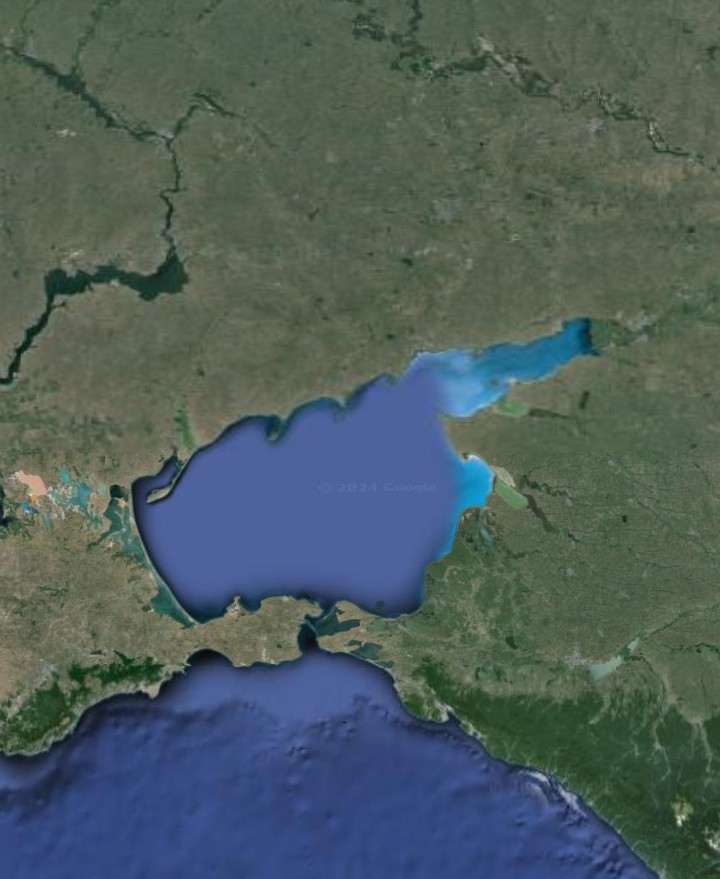
Now, if we consider a point on the present equator, in northern Brazil, at about 60 degrees west longitude, we notice something really interesting. Both of these lines described here, if continued to the southwest, lead to this point. Also the former equator that I pointed out, showing as the northeast to southwest section of the Mid-Atlantic Ridge from about 20 to 40 degrees of north latitude and reemerging on the other side of South America as the undersea Nazca Ridge extending far into the Pacific Ocean to the southwest from the coast of Peru, south of Lima, also passes right through the same point.
In the center of this image is the seafloor section of the Mid-Atlantic Ridge to which I am referring. The line of this section of the ridge, the line through Lake Balaton-Po Valley-Balearic Sea and, the line through the northeastern section of the Sea of Azov all meet at a point in Brazil on the present equator at about 60 degrees west longitude.

That is because all three of these lines are at least partially former equators, which pulled magma toward them by centrifugal force leading to the features that we see today. First, the established equator before the poles shifted, then the others forming because the spin of the earth would pull magma toward the equator, as the equator shifted along with the poles to it's present position.
Look at the following image of the Caspian Sea. It is the result of three lines of emergence. First, the northeastern section, reminiscent of the Sea of Azov, is the same former equator as went through Lake Balaton-Po Valley-Balearic Islands, and then shifted as the earth's poles moved to the line from the northeast extension of the Sea of Azov. It shifted again, by about the same amount, to form this northeast extension of the Caspian Sea. Second, The north-south axis of the Caspian Sea points directly to the former south pole at the undersea ridge structure around Madagascar, because it is a former longitudinal line of emergence. Third, the much deeper southern portion of the Caspian Sea is due to another line of emergence which formed the deep southern portion of the Black Sea and the broad valley that continues east of the Black Sea through the country of Georgia.
This is an outline of the broad valley, a prominent line of emergence, that continues east from the Black Sea, through the country of Georgia, to form the deep southern end of the Caspian Sea.

The wide lowland of northern India and Pakistan can then be seen to be along this line of what would have been a former equator, where we would expect an exceptional amount of magma emergence. The Indian subcontinent is known to have collided tectonically with Asia, but this broad lowland in the north, hosting cities such as Lahore, Delhi and, Calcutta, require some special explanation, and this magma emergence along the former equator provides it. This is the same main line of magma emergence as that through the southern half of the Black Sea and southern portion of the Caspian Sea, and it continues on the other side of the Original Impact Line, which is the band of mountains and high rocky terrain through Turkey and Iran to central Asia.
The broad valley across the country of Georgia, which also forms the deep southern (Turkish) part of the Black Sea, continues through Azerbaijan, and then, on the other side of the Himalayas, as the broad Ganges Plain of northern India,


There are three of the typical broad valleys, representing parallel lines of emergence, in southwestern Spain, the southernmost of which is the one that hosts the city of Seville. These look very much like the lines from former equators, as the equator gradually shifted from it's former to it's present position. The spin of the earth would pull magma from below to the equator, and former equators or sections thereof would continue as lines of emergence long after the equator had shifted.
Notice the three broad valleys of southwestern Spain, the southernmost of which hosts the historic cities of Seville and Cordoba. These look very much like emergence lines from a shifting former equator. The perpendicular broad valley across northeastern Spain, hosting the city of Zaragoza, is a perpendicular line of emergence.
19) SOUTHEAST ASIA
I find it very significant that the circular area of magma emergence in southeast Asia, forming lowlands in Thailand, Cambodia and, Vietnam, is actually more oval-shaped, being aligned from northwest to southeast. This would make it perfectly aligned along the former equator as it neared the location of the present equator, where we would expect to find a greater than usual amount of magma emergence.
In the center of the following image is the elongated emergence basin comprising Vietnam, Cambodia and, part of Thailand. In the upper left, we see the long north-south valley through Myanmar that is part of the Great Valley Of Asia. The red line represents low emergence mountains, brought about by the basin, on the south coast of Cambodia.

The same can be said, on the opposite side of the present equator from it, with regard to the Great Artesian Basin of Australia which is also a similar zone of magma emergence with the typical low emergence mountains.

Southeast Asia is set of parallel emergence lines, somewhat resembling that of California. There is the familiar lowland surrounded by mostly low mountains. A typical short and low range of emergence mountains can be seen as forming the south coast of Cambodia.
The lower left of the image, within Cambodia, is the line of emergence mountains that forms the south coast of the country.
The long Isthmus of Thailand (reminiscent of the strip of land between the Black Sea and Sea of Marmara) seems very likely to have formed in the gap between two parallel lines of emergence, just as the Sierra Nevada and Cascades Ranges did in the western U.S. The Malay Peninsula is likely formed between two former equators, how else is there to explain it?

The northward lowland extension of the Gulf of Thailand is a much shorter line of emergence parallel to the Great Valley of Asia through Myanmar (Burma) to the west, with the focal point of southeast Asia to the east. These look on the map like three parallel lines of lowland with low emergence mountains between them.
There is a simple explanation for these two parallel lines of emergence in southeast Asia, just to the east and also parallel to the Great Valley Of Asia described above. This area is a zone, similar in nature and on the opposite side of the world to the Caribbean, where the present and former equators meet so that we should expect an exceptional volume of magma emergence.
19b) SOUTHEAST ASIA AND THE INDIAN OCEAN
Notice that the Indus Valley of Pakistan points directly at the first south pole, where the Mid-Atlantic Ridge bends in the south Atlantic Ocean. This is because it is a former longitudinal line of emergence from the first polar era. Why else would there be such lowland between high mountains to the west, and higher land in India to the east?
The Indus Valley is a former longitudinal line of emergence that points directly toward the former south pole, as the undersea ridge structure around Madagascar. The broad lowland of the valley has high and mountainous terrain on either side.
But what about the north of India, alongside the Himalayas including the borders with Nepal and Bhutan? This wide strip of lowland with the highest mountains in the world to the north, and much higher ground to the south, looks just like a line of emergence.

This line across the north of India extends eastward, ending up as a much narrower valley in the far northeast of India, in the state of Assam, and running parallel to the line through Myanmar (formerly Burma), which was the first line of emergence that I identified and which I named "The Great Valley of Asia", as explained above. There is a range of low mountains between the two lines, which appear as very typical emergence mountains. The emergence valley through Assam has the river flowing through it.

20) AUSTRALIA
The Gulf of Carpentaria on the north coast of Australia appear on the map as the "entrance" from the eastern extent of the Great Valley to the Great Artesian Basin to the south. This is a continuation of the magma emergence in the area where the present and former equators meet, south of the present equator.

Portions of the Great Artesian Basin are below sea level, which immediately makes it appear as one of these zones of emergence, since the Dead Sea and California's Death Valley are also on lines of emergence.
Furthermore, there are low and short ranges of mountains around the Great Artesian Basin which are otherwise difficult to explain, such as the Grey Range-Barrier Range as well as the higher Flinders Range north of Adelaide. The Flinders range is a range dividing two lines of emergence, with the vast lowland area of New South Wales being the zone to the east of the Great Artesian Basin. The dark line is the Flinders Range.

This "new" basin in New South Wales formed as the land moved tectonically eastward over the north-south line of emergence that connected to the "Great Valley Of Asia", to the north. This entire arrangement of emergence lines resembles that of the Mid-Atlantic Ridge on the other side of the world. The Flinders Range formed when magma from the old and new emergence basins went up against each other, in a way similar to that of the Sierra Nevada and Cascades in the U.S. west.
The emergence from the "new" basin, the one in New South Wales, can be seen to have "broken" the Great Dividing Range, which was an impact line from a Continental Asteroid. There is no other way to explain why it would appear "broken" in this way.
Spencer Gulf, west of Adelaide, forms a straight line with Lake Torrens and Lake Eyre North, which would have been along the line of emergence represented by the Great Artesian Basin. Yorke Peninsula, separating Spencer Gulf from the Gulf of St. Vincent, appears to be a geological extension of the Flinders range.
You can see that, in so many ways, the Great Artesian Basin of Australia resembles the Great Basin of the American west, which we know is the result of lines of emergence. Also notice how the lowland of New South Wales resembles the lowland basin with mountains around it of southeastern Europe. I would definitely say that this represents the earth's former equator as it extended south of the present equator.
21) EUROPE AND SIBERIA
In southeastern Europe lies what is one of the most prominent focal points of emergence lines anywhere in the world. Hungary, Croatia and, northern Serbia make up the low area of the focal point. Low ranges of emergence mountains formed between the tangle of lines.
How else could the Carpathian Mountains and the Sudeten Mountains, which form the border between Germany and the Czech Republic, form? The Carpathians, in particular, have a highly-unusual form for a range of mountains. On the map, they resemble a curved upside-down question mark, visible in dark green.
Inside the outside lower curved part of the question mark formed by the Carpathians, southern Romania and northern Bulgaria, is the western end of an emergence line which forms the northern side of the Black Sea. This is the same line that bent northward to form the Sea of Azov, in Ukraine, and through the Volga Valley.
There could be a tectonic collision factor involved in the Carpathians also, since there is some oil in Romania. How could we account for this collision? The comet impact that we will see formed Italy and broke off a section of the Original Impact Line upon which it landed. The red line in the following image is a portion of the Original Impact Line that was diverted northward by the comet impact that formed Italy. The purple dot is the Carpathian Basin. The dislodgement of part of the Original Impact Line over it caused a secondary basin to emerge to the north of the Carpathian Basin. This is the Sudeten Basin and the low emergence mountains around it form the border between Czechia and Germany.

The Sea of Marmara, marked by the red dot in the following image, seems to represent a southeastward line of emergence, joining one across the southern portion of the Black Sea that also forms the east-west valley through Bulgaria. Fildiz Daklari is a typical short range of low emergence mountains.

The lowland gap between the two mountain ranges in Bulgaria is a line of magma emergence that continues southward to form the Sea of Marmara.

Considering the Adriatic Sea between the Italian Peninsula and Croatia, why would there be such a broad strip of low ground, which joins the Po Valley across northern Italy, and which runs between between the two parallel ranges of mountains, of which one is of volcanic origin and the other isn't? This makes the Adriatic similar in this respect to the Persian Gulf, which we know is certainly a line of emergence, and the Adriatic Sea points directly toward what we know is the former south pole as the undersea ridge structure around Madagascar, making it clear that it was once a longitudinal line of emergence.

Also interesting that if we follow the Gulf of Suez, at the northern end of the Red Sea, in a straight line, it seems to continue as the Adriatic Sea. Since the Gulf of Aqaba, on the other side of Sinai, continues as a line of emergence across Israel and beyond, why should not the nearby Gulf of Suez do the same and continue along the line of the Adriatic Sea?
Let's now go to the western Mediterranean area. I am certain that the Po Valley, across northern Italy, is a line of emergence. Notice that to the west, there is a shape outlined by Spain's Balearic Islands that appears to be a continuation of the Po Valley. The mountain range along the north coast of Majorca looks just like typical emergence mountains, and very similar to those in the Crimea which were formed by the emergence line across the northern Black Sea as it bent northward to form the Sea of Azov
If the Po Valley, across northern Italy, was formed by the emergence along a former equator, it would continue to the southwest to form the Balearic Sea.

If we continue further to the southwest along this line, valley in southern Spain which includes Seville and the northwestern lowland of Morocco could possibly be a further continuation. This looks very much like the line of a former equator before the poles shifted because of the impact of a Continental Asteroid.
The valley across the south of Spain, containing Sevilla and Huelva, looks like an emergence line continuation of the former equator line of the Po Valley and Balearic Sea. The perpendicular broad valley, in the northeastern part of Spain containing the city of Zaragoza, would then be a former longitudinal line of emergence.
If this is a continuation of the Po Valley as a line of emergence, then it would explain the wide northwest-southeast valley across northeastern Spain, with mountains on either side, which hosts the city of Zaragoza. if we continue this Zaragoza Valley to the northwest, we see that it continues as a ridge across the ocean floor of the West European Basin until it joins the Mid-Atlantic Ridge.
There are two major roughly southwest to northeast valleys across southwestern Spain, the southernmost one hosting the famous city of Seville. South of these lie the parallel lowland coastal area of Morocco. If we look on a map of the ocean floor, we see that these parallel stretches of lowland continue offshore as undersea ridges. This makes it clear that we can classify them as lines of emergence, specifically the remnants of a shifting former equator.
22) THE BLACK SEA AND EASTWARD
The Black Sea is formed of two roughly parallel lines of emergence that appear very much like former equators. The reason for this is that the two lines were displaced northward by the Original Impact Line, which greatly hinders magma emergence. The line which begins in Bulgaria, along an east-west axis and bordered by low mountains, extends eastward across the southern portion of the Black Sea. This starts out as parallel to the line which we saw bends northward from the Black Sea across Russia, and on to Siberia. The Balkan Mountains of Bulgaria form a dividing line on land between these two lines of emergence, which together form the Black Sea.
The line from Bulgaria, across the southern Black Sea, continues through Georgia (the former Soviet republic, not the U.S. state), Armenia and Azerbaijan. It forms the deep southern portion of the Caspian Sea, and ultimately forms the east-west valley in the far north of Afghanistan.
The deeper southern portion of the Black Sea is formed of a line of emergence that runs parallel to the Turkish coast, and continues eastward from the sea to form the V-shaped lowland that can be seen at the eastern end of the sea, in Georgia, between two sets of mountains and marked by the red dot.

At the western end of the Black Sea, the same line of emergence continues to form the east-west valley through the center of this map of Bulgaria. The parallel line of emergence, which forms the western part of the northern Black Sea, continues westward to form the curve in the Carpathian Mountains, the southern part of this curve can be seen just north of the valley in the map.
It is possible that the so-called Caspian Depression, to the north of the Caspian Sea, could be the result of lying between these two lines of emergence. This would be similar to the low area of the Great Basin in the western U.S. lying within the rough C-shape of the line of emergence which we saw there.
I) OTHER LINES OF EMERGENCE
BRITAIN AND NORTHWESTERN EUROPE
There are other lines of emergence, which explain many landscape features but which are not as directly connected to the impacts of the Continental Asteroids and the shift of the earth's poles and equator.
23) THE PENNINES AND BRITAIN
One geological mystery is how England's Pennine Mountains formed. These mountains form a roughly north-south line along the length of the northern part of the country. How can we explain the puzzling configuration of the Welsh Mountains seeming to be a southward continuation of the Pennines, but being some distance to the west, can be easily explained by having been pushed there by the long-ago tectonic collision of Italy with southern Europe which formed the Alps.
But that still does not explain how the Pennines and the Welsh Mountains formed in the first place. These mountains are not volcanic in nature, nor do they seem to be the result of tectonic collision since the primary direction of continental drift was northward and these mountains are aligned north to south.
I once thought that the Pennines might once have been a part of the Mid-Atlantic Ridge, since the straight line north-south portion of the ridge in the south Atlantic Ocean forms a straight line with the Pennines if we continue the line far to the north. In fact the Ural Mountains, which run north-south across Russia, are just as mysterious as the Pennines and also form a straight line with the north-south section of the eastward continuation of the Mid-Atlantic Ridge which extends northward toward the Red Sea.
But when I had developed this Lines Of Emergence Hypothesis, the solution to the formation of both of these ranges of mountains became very clear. These are north-south longitudinal lines of emergence from the present polar era. We saw that the continents, gradually shifting by tectonic drift, move over these lines of emergence. If the line of emergence is still active, the magma will spread the land of the continent apart as it spreads along the former sea floor, and the result will be a broad valley and possibly a range of the low "emergence mountains" that tend to form along the edge of the line.
But if the line of emergence has become inactive when the continent moves over, it will force the land of the continent upward over the ridge because the solidified magma will act as a ramp. The result will be a range of mountains on the continent above the line.
If we look at a physical geography map showing the ocean floor, we see that there is an undersea ridge running north-south in the south Atlantic Ocean. This line is active today, as a section of the Mid-Atlantic Ridge, and if extended northward leads directly toward Britain. When the continent moved over this ridge, before it's northern sections shifted westward, it forced the land upward and the result is the Pennines and Welsh Mountains of today. Part of the line broke away when Italy collided with southern Europe, and this is why the Welsh Mountains appear to be a continuation of the Pennines but are positioned some distance to the west.
This map shows the Pennines with the Welsh, or Cambrian, Mountains which were pushed westward from the Pennines, to the lower left.

Notice that if we follow the line through the Pennines and continue southward, we arrive at the French peninsula where Cherbourg is located, the Cotentin Peninsula.
It is very probable that this underlying ridge was indeed the original line of what is now the Mid-Atlantic Ridge. There are other ridges to the west, on the floor of the Atlantic Ocean, that could have been subsequent versions of the Mid-Atlantic Ridge as it shifted westward, due to the nearby tectonic movement of the Eurasian land mass, to where it is now.
All of northwestern Europe was once land. The shallow seas such as the North, Baltic and, Irish Seas were carved away to below sea level by moving glaciers, driven by the centrifugal force of the earth's rotation, during the ice ages. The reason that Britain remains dry land is obvious, it was shielded by not only the Pennines and Welsh Mountains but also those of Scotland.
There is one point, to the north of Britain, where this undersea ridge pokes above the water level. Denmark's Faroe Islands are composed of the magma from this ridge, which has long since solidified. The difference between Britain and these islands is that there is a continental land mass which covered the ridge to form the Pennines, but I looked around the Faroe Islands on Google Street View and this is what it looks like without the continent covering it.
Notice that the Faroe Islands are in the form of a "T". The vertical portion of the T is the same line as the Pennines. The top, horizontal, portion of the T can be seen to form a perfectly strait line with the elongated lake and inlet in Labrador, known as Lake Melville, and the northern section of Lake Superior. This line points directly to the Great Basin of the western U.S., which was the second north pole. This seems to make it clear that the line which forms the top of the T on the Faroe Islands was once a longitudinal line of magma emergence from when the north pole was at the Great Basin.
Remember that lines of emergence tend to become permanent features of the earth's geography when they begin in polar era, and are "reactivated" as something else in a successive polar era.
The Faroe Islands, to the north of Britain, form a "T" shape, with the north-south line being in line with the Pennines, and the east-west line being in line with a former longitudinal line of emergence across North America.
No land on this earth is as geologically confusing as Britain. It looks, on a physical geography map, like a jumble of geological pieces that do not quite fit together, and that is just about what it is. The southern portion of Britain is the result of a section of the north-south chain of the Pennine Mountains being displaced to the west by the tectonic collision of Italy, pushed by Africa, with Europe. The displaced section is the Welsh or Cambrian Mountains, since Cambria is the old name for Wales.
The same pattern can be seen in continental Europe. The broad Rhone and Rhine Valleys seem as if they might have once been a continuous line, but the Rhone Valley has been shifted westward in the same way and for the same distance as the Cambrian Mountains. The Rhone and Rhine are valleys, rather then mountains, because they were still an active longitudinal line of emergence when the land of western Europe moved tectonically over it.
On continental Europe, the Rhine River, in the north, and the Rhone River, to the south, appear to be in broad valleys that were once one valley, until the southern part was pushed westward in the same way as the Welsh (Cambrian) Mountains being pushed westward from the Pennines.
24) PIECES OF THE ORIGINAL IMPACT LINE
I arrived at an understanding of the "Original Impact Line". This is the long line of otherwise unexplained mountains and high plateaus extending across the eastern hemisphere from Greece and the Balkans, through Turkey and Iran to the Himalayas and the Tibetan Plateau, and beyond. This, along with Antarctica, is the original rock mass left by the last Continental Asteroid that formed the moon as well and is often referred to by scientists as Theia. My theory is that it also explains the continents, and so much else about the earth, as well as the moon.
My theory of Britain is that the mountains of northern Scotland is actually from a piece of this Original Impact Line that was carried by the tectonic movement of northwestern Europe to the northwest. Land other than this Original Impact Line tends to be either of volcanic or magma emergence origin, or sea floor that has been forced upward by tectonic movement. The story of the northern part of Britain begins when this piece of the Original Impact Line collided with the longitudinal line of emergence represented by the Pennine Mountains. The apparently mysterious straight line across northern Scotland is known as Glen Mor.

My conclusion is that the mountains of Scotland are not related to the Appalachians of North America, as is believed by some, but the rocky mass of most of Newfoundland may be another loose piece of the Original Impact Line that was once part of the same mass as Scotland until separated by the spread of the sea floor caused by magma emerging along the line of the Mid-Atlantic Ridge.
The impact, most likely of one of the comets which provided the water on earth, took place which shattered the western end of the Original Impact Line. Land gradually moved tectonically to the northwest, crossing this line and carrying many of the pieces of the shattered end of the Original Impact Line with it. The westward curve of northern England can be explained simply as being the impact against the line of Scotland to the north.
Scotland was a large piece of the Original Impact Line that split in two upon tectonic impact with the line of emergence represented by the Pennine Mountains. The split can be clearly seen to have been along the straight line of Glen Mor. The northern part of Scotland looks exactly like a mass that has split in two upon impact, along the mysterious straight line of Glen Mor. The southern part of Scotland is a portion of the Pennine line that was knocked horizontal by the impact.
One question that might arise is why western Europe was moving tectonically to the northwest, when we know that the general tectonic movement of continental masses is northward, with the earth's rotation adding it's eastward momentum. But remember the shifting of the poles. The north pole made it's way from the Great Basin of the western U.S., across what is now Hudson Bay and the Foxe Basin, of northern Canada, to it's present position in the Arctic. This means that when the tectonic movement of western Europe to what is now northwest began, it actually was northward.
Lines of magma emergence gradually shift as land moved tectonically over them. The longitudinal line represented by the Pennines curved to the northwest, but it did not shift as fast as the land was moving and what is now the mountains of Scotland being carried along with the land collided with it. Ordinary land can slip over this longitudinal line of emergence, but the mass of the Original Impact Line being carried with it cannot.
When the piece of the Original Impact Line collided tectonically with the longitudinal line, both of them broke into several pieces. The aftermath of this collision explains the puzzle of Britain as we see it today. Scotland is actually three pieces, the east-west southern part of the country, then the northern part split in two, due to collision with the line of the Pennines, along the straight line of Glen Mor.
Just look at the mountains of northern Scotland on the map. Doesn't it look like it was once one piece that was broken in two, along the strait line of Glen Mor?
The north coast along both the Northwest Highlands and the Grampian Mountains both form straight lines that appear to have once been one line until the western portion was pushed to the north as the two sections split along the straight line of Glen Mor.
How else is there to explain this perfect straight line across Scotland other than a split when a piece of the Original Impact Line collided with the Pennines?
The longitudinal line of emergence with which it collided was also broken into three pieces by the collision. One broken off segment of the longitudinal line was driven southward and ended up by the eastern side of the Pennines to form the Cumbrian Mountains of northeastern England, where the fabled Lake District is located.
There is a broad valley between the two mountain ranges, known as Edenside. This valley formed because the approach of one section of mountains to the other forced land between them upward so that the two sections could not actually come into contact, but left the valley between them. This broken section represented by the Cumbrian Mountains actually seems to extend as far south as Manchester.
The Cumbrian (not Cambrian) Mountains are a section of the Pennines that were broken off by the collision of a part of the Original Impact Line, and the lakes that it encloses forms northern England's picturesque Lake District.

Another section of the Pennines that was broken off by the collision is the Southern Uplands of Scotland. This is the southern portion of Scotland which extends roughly east-west, actually slightly southwest to northeast. The Outer Hebrides were later separated from Scotland by magma emerging along a line of emergence.
The Southern Uplands of Scotland were a section of the north-south Pennines that was broken off by the collision of a large piece of the Original Impact Line which knocked the broken section more than 90 degrees. The other three major sections of Scotland are composed of pieces of this part of the Original Impact Line.

The lines of emergence shift to avoid land that is tectonically moving over them, and so hindering the flow of magma. But they do not shift as fast as the land is moving and the shift is very gradual with some activity remaining in the old line for a long time.
The part of Scotland that broke off and shifted northward with the collision, now the Northwest Highlands, applied pressure to the adjacent land. The land which was forced upward along this line of pressure formed the Orkney Islands, just off the north coast of the Northwest Highlands.
When the pressure along the same line reached the former position of the longitudinal line of emergence, before it began shifting to the northwest due to the encroaching land, it caused more magma to emerge along the line because there was still activity in it. The emergence of this magma formed the Shetland Islands, which are positioned perfectly to have come into being as a result of this. You can see on a map of the Shetland Islands that the main line of the islands extends perfectly north-south, which would be along the original longitudinal line of emergence.
There seems to be a third piece of both the piece of the Original Impact Line which formed Scotland, and the ridge of the longitudinal line of emergence with which it collided. The two remain together to form the northern part of Ireland. This includes the very northern section of the island, including Ulster. The highland of Connaught, the northwestern section of Ireland from the north coast to Galway Bay, is probably another piece of the Original Impact Line and the longitudinal line of emergence.
Ireland is formed of pieces of the Original Impact Line, particularly the north and south, which forced up seafloor into dry land between them by their movement relative to one another. remember that the parallel peninsulas in the southwest of Ireland are an example of what I have defined as tridentation, the spreading apart of a rocky continental land mass by an active line of magma emergence beneath it. Large pieces of the Original Impact Line in Ireland are indicated by red dots.

Before the piece of the Original Impact Line reached where it is today, to form the north of Scotland, the edge of it collided with the longitudinal line of emergence further south, and a piece of the Original Impact Line broke off there. This piece is now the North York Moors, just south of the city of Middlesbrough on England's east coast.
The North York Moors, shown in the following image by the dark area, is a piece of the Original Impact Line that broke off before the section of the Original Impact Line collided with the line of the Pennines to form Scotland.

This broken piece forced up land between it and the line of the Pennines, just as did the Cumbrian Mountains when that piece broke off and came to rest beside the Pennines. This left valleys between the two, and today there is the Vale of York and the Vale of Pickering adjacent to the North York Moors just as there is Edenside between the Cumbrian and Pennine Mountains.
When land moves tectonically, and collides with something, it produces an effect somewhat like a train with a long line of cars that suddenly slows. The cars behind will still have their momentum, and there is a risk that they will "pile up". Similarly, the land following tends to be forced upward when this happens.
An ideal example is Florida being formed by seafloor that was forced upward during the tectonic collision which formed the Appalachians. Such land tends to be flat and to get lower in elevation as we move back further from the collision front. This can be seen in the flat landscape of Florida, with the lower elevation in the south that hosts the Everglades.
Florida, and the shallow sea around it, was forced upward by the sliding collision between what is now North America and what is now Africa, which formed the mountains and ridges of the Appalachians. Flat and low-lying Florida was at the trailing end of the collision, and was forced upward like the cars on a train, if the train should drastically slow while the cars still have their momentum.

It is also seen in Britain, and on the nearby continent. East Anglia, the outward bulge on the southeast coast of England, with it's flat landscape is positioned ideally to have resulted from the meeting of the moving land mass with the longitudinal line of emergence represented by the Pennines. The same for the flat and low elevation of the Netherlands. The sea between the two was formed by ice age glacial movement. Puglia, the flat southeastern peninsula of Italy was also formed in the same way as Florida when remnants of the Original Impact Line, which form part of Italy, collided with Europe.
Britain is a mid-sized country, and if we want to really understand it's geography it is necessary to look beyond it. If we look further south in Europe, we can see where the land mass of Scotland must have come from. Look on a physical geography map at the mountains of Croatia, along the Adriatic coast. This must be the western end of the Original Impact Line. The line of the mountains changes direction, and points to the northwest. If we follow this line, we find that it leads directly to the mountains of northern Scotland.

This is what the Original Impact Line looks like. Mountains that are neither of volcanic origin nor were formed by tectonic collision. They came from the Continental Asteroids. The Original Impact Line extends from Greece and Turkey through Iran to the highlands of central Asia, including the Himalayas. The Himalayas were formed by the collision of India with Asia, but it must have been high and rocky ground already for the Himalayas to be so high.
The mountains on the eastern side of the Adriatic Sea are aligned northwest to southeast because this is the direction into which the Original Impact Line was forced by the comet impact which created Italy and left the portion of the Original Impact Line west of here as tectonically drifting fragments that we are discussing here.
As far as I can tell, the pieces of the Original Impact Line are all rocky features and islands, all in western Europe, that are difficult to explain any other way. These include the island of Corsica (but not Sardinia, which is volcanic), The Tuscan Archipelago of islands between Corsica and mainland Italy, Malta, possibly part of Pantelleria (although Pantelleria has a volcanic element as well), the Massif Central in southwestern France, Mont St. Michel on the Normandy coast, the North York Moors in northern England (which almost certainly was a piece of Scotland which broke off), southern Ireland (including the parallel peninsulas in the southwest of the island which typically form when a piece of Original Impact Line gets positioned over a line of magma emergence), the high rocky areas of northwestern Ireland in Counties Mayo and Donegal, Switzerland must have been a high and rocky fragment of the Original Impact Line even before Italy collided with it to form the Alps, The mountains of Scandinavia seem certain to have been a dislodged segment of the Original Impact Line resulting from the likely comet impact and finally, the long elongated island in the Russian Arctic to the east of Scandinavia appears very much as a piece of the Original Impact Line which drifted tectonically until coming to rest against the emergence line represented by the Ural Mountains.
Furthermore, if the Massif Central of southern France was another stray piece of the Original Impact Line, the gap between that and the coastal mountains of Croatia is just about perfect for the length of the piece which was to become the mountains of Scotland to be taken from here.
The mountains of southern Ireland seem to be difficult to explain. We can see that the mountains across the northern part of Ireland are a continuation of those in Scotland, but what could have produced the mountains in the south? Across southern Ireland are low mountains, valleys, lakes, peninsulas and, bays that are aligned in parallel from east north east to west south west.
These mountains are too high to be of glacial origin, but too low to be the result of a tectonic collision. This includes the Wicklow Mountains, to the south of Dublin, which is not parallel to the others because these are a part of the curve of the emergence line rather than of the "shortcut" lines across the curve. From these mountains and valleys come some of the most famous of Irish county names such as Kilkenny, Kerry, Tipparary and, Cork.
Fortunately, this hypothesis provides a simple explanation. The north-south peninsula on the north coast of France, hosting the city of Cherbourg, is a straight line continuation of the line of the Pennines In England, to the north, remembering that the Welsh (Cambrian) Mountains were once a part of this line that were broken off and pushed westward by later tectonic movement when Italy collided with Europe, and also formed the Alps. There is still a long gap in the line, where the English Channel is now located.
But of a section of the line was broken off and pushed to the northwest, as Europe moved in that direction, by another piece of the Original Impact Line, that would explain the high ground of the peninsula of Devon and Cornwall as the dislodged piece of the longitudinal line and the mountains of southern Ireland as the piece of the Original Impact Line. The parallel peninsulas of southwest Ireland, between the mountain ranges of southern Ireland, can easily be explained as the piece of the Original Impact Line positioned over a line of emergence, the process that I refer to as tridentation.
The southwestern peninsula of England, Devon and Cornwall, is neither volcanic nor of tectonic collision origin. It is from a piece of the Original Impact Line, or the piece of the line southward from the Pennines that the collision of the Original Impact Line dislodged.

St. Michael's Mount, like the mount on the French side with the same name, Mont St. Michel, are on small fragments of the Original Impact Line.
This line of the Pennine Mountains of England, and the Contentin Peninsula of northern France, was once what the Mid-Atlantic Ridge is now, the main line along which magma emerged from below. When the land mass of northwestern Europe moved tectonically over it, the line was still active with magma emerging. This is why the line shows in the landscape as both mountains or islands, and also broad valleys created by the spreading of the land due to magma emergence.
This shows that, if a line along which magma is emerging is not covered by a land mass, it will produce mountains. But if it is covered by a land mass, it will produce broad valleys in that land.
25) BRITTANY AND LAND'S END
I noticed something really amazing that has never been pointed out before concerning how these segments that were once part of the Mid-Atlantic Ridge affect the physical geography of coastal western Europe. I pointed out the broad valleys across Portugal and Spain that were the results of lines of emergence that can be seen as extending out to sea. But those valleys were from when the lines of emergence were still active as the land gradually moved tectonically over them.
There are two peninsulas that are not quite parallel, Brittany in France and the peninsula in England which includes Devon and Cornwall, and which terminates at Land's End. These are both rocky peninsulas that are difficult to explain geologically. The impact of Italy with Europe, which broke the Welsh (Cambrian) Mountains off from the Pennines, and shifted them westward to create Wales came later.
The western part of the English Channel, west of the peninsula in Normandy which hosts the city of Cherbourg, the Contentin Peninsula, was created in much the same way as Lake Ontario, in North America. Layers of rock strata were squeezed downward between the nearly-parallel peninsulas of Brittany and Cornwall. Lake Ontario was similarly squeezed between the collision from which formed the Appalachian Mountains, and the Canadian Shield to the north. The depths of this western section of the English Channel are very similar to that of Lake Ontario.
Brittany was a section of the longitudinal line of magma emergence represented by the Pennine Mountains and the peninsula in Normandy, which hosts the city of Cherbourg. What is now Brittany was a section of this longitudinal emergence line which was broken off and rotated more then 90 degrees, by the land mass of western Europe moving tectonically to the northwest, to it's present position. The peninsula of Brittany seems to have moved much like a hinge on a door against the remaining section of the longitudinal line, the Contentin Peninsula in Normandy.
Devon and Cornwall is the peninsula to the north, Brittany is the peninsula to the south. The Contentin Peninsula is the north-south peninsula to the east. Jersey and Guernsey are among the Channel Islands.

The Channel Islands, including Jersey and Guernsey, are in the area upon which this "hinge" was closed so that land would be forced upward to form these islands. The large V-shaped area of lowland in southwestern France is seafloor which was forced upward by this movement.The Iberian Peninsula, Spain and Portugal, collided later to form the Pyrenees Mountains. The peninsula of southwestern England, Cornwall and Devon, is the displaced section of this longitudinal line of emergence from between this peninsula off the coast of Normandy, and the Welsh Mountains to the north.
26) SOUTHERN ENGLAND'S EMERGENCE LINES
There is an emergence line across Britain, extending from the curve in the Mid-Atlantic Ridge to the Gulf of Bothnia between Sweden and Finland. This line includes the ridge on the Atlantic seafloor which is within it's line, the Bristol Channel, The Wash on the east coast of England, and the Skaggerak between Denmark and Norway. Notice how all of these form a straight line.
If the Rhine Valley, in Europe, is a longitudinal line of emergence from the present polar era, and the Rhine River flows through it, then why does the river curve so that it actually meets the sea in the Netherlands? The reason is that the river meets another line of emergence. There is a nearly east-west line of emergence, which is rare. This line of emergence meets the sea at Weston Super-Mare, on the shore of the Bristol Channel. There is a well-defined emergence bay at Weston Super-Mare, similar to the Bay of Naples. There are lines of typically low emergence hills extending inland from Weston Super-Mare.
Notice that this east-west line, extending eastward from Weston Super-Mare forms a line with the straight line north coast of Kent, on the Thames Estuary on the east coast of England. This line is what forms the Thames Estuary. The County of Somerset, where Weston Super-Mare is Located is where this emergence line joins another small emergence line, that which forms the Severn Vale and runs northward to Liverpool between the Welsh (Cambrian) Mountains and the former north-south line of the Pennine Mountains.
The north coast of Devon, on the Bristol Channel, forms a straight line with the north coast of Kent, on the Thames estuary, and is a line of emergence that continues into Europe to form the outlet of the Rhine River.

We know that we can expect an exceptional amount of magma emergence where two lines of emergence meet, and this is why there is lowland that is actually below sea level in Somerset, at Weston Super-Mare. This is also where these two lines of emergence join the one discussed above that ran through the Bristol Channel to The Wash, on the east coast of England. Anywhere in the world, land that is below sea level is almost certain to be associated with lines of magma emergence, which pull the land apart from below to create the drop in elevation. These lines of emergence just explain so much in Europe.
27) THE MEDITERRANEAN
I noticed that all of the islands in the Mediterranean Sea are neatly explained by this theory.
As the planet rotates, magma also tends to be pulled toward the equator by centrifugal force and to emerge in that region. The centrifugal force also causes magma to emerge along periodic longitudinal lines stretching from pole to pole, in order to balance the equatorial emergence according to the rules of fluid dynamics. The rotation of the earth is what causes magma to emerge along lines, but if it becomes concentrated enough it can emerge from a point, which is known as a volcano.
There are several lines of emergence across the Mediterranean. Two of them are former longitudinal lines and two appear to be sections of former equators, one is a north-south longitudinal line from the present polar era. There is also the impact of a long-ago comet in what is now the Tyrrhenian Sea. This impact is the only reason that I can see to explain why a tight loop of volcanic lands, Italy, Sicily, Sardinia and, Corsica, surrounds a very deep sea.
All of the islands in the Mediterranean are explained by these factors. Remember that a line of emergence tends to create a ridge on the sea floor (an ideal example is the Mid-Atlantic Ridge), but a broad valley on land as the emerging magma spreads the land apart as it moves tectonically over it. More magma tends to emerge where two lines intersect and low emergence mountains typically border the broad valleys of lines of emergence on land.
First we have the emergence line of the Adriatic Sea, between Italy and Croatia. This is a line of emergence that extends to the southeast to include the Aegean Sea, between Greece and Turkey, and then to the Red Sea, which points at the former south pole, the undersea ridge structure around Madagascar.
Then if we consider the Adriatic Sea, on the other side of Italy, as a line of emergence, it explains not only why there is much more land mass in the Italian peninsula then there is in the three islands comprising the circle, Sicily, Sardinia and, Corsica. It also explains why Italy is shaped like a boot, with a heel and toes.
Magma emerged in a circle around the Tyrrhenian comet impact, which was also responsible for breaking the Original Impact Line west of Albania and Greece into fragments, but the Adriatic Sea forms a line of emergence. The greatest amount of magma emerged between the circle and the line, to form the peninsula of Italy. Further south, the line and the circle diverge to form a gap between them. The heel is a continuation of the line of the Adriatic, and the toe of the circle of the Tyrrhenian. The gap between the two is seen as the Gulf of Taranto.
Italy is explained by magma emerging from a comet impact in the Tyrrhenian Sea, in the center, incorporating some of the Original Impact Line, which it landed on and broke apart, and pushing against the magma emerging from the emergence line of the Tyrrhenian Sea. Notice how Sardinia and Corsica, to the left, form a perfect straight line. This is because they are composed mostly of pieces of the broken Original Impact Line that came up against a present polar-era north-south line of magma emergence.

Just remember also that former longitudinal lines of emergence may have some curvature to them because when the earth shifted on it's axis to accommodate the additional mass from the impact of the Continental Asteroids, only one former longitudinal line of emergence can remain a straight line and that is the one directly between the former poles that is named "The Cuba-Phoenix Line" in the theory. When the earth shifted on it's axis, to a new north and south pole, the equator along which magma tends to emerge due to centrifugal force if rotation would have to shift also and this is why segments of former equator can still be seen.
28) CYPRUS
Next, look at the eastern Mediterranean island of Cyprus. There is a long arm of land extending to the northeast of the island. The arm points to the Gulf of Alexandretta in the very northeast corner of the Mediterranean. This is a line of emergence that leads to, and forms, the Fertile Crescent and the Persian Gulf. Cyprus, as a whole, is the result of land being forced upward by the pressure from collision of the Arabian Plate.
An interesting thing about the island of Cyprus is that it appears to actually be two separate land masses that are joined together. There is the "arm" peninsula to the northeast, along with the north coast, and then there is the separate central mass of the island. There is a low range of mountains across the north coast that appear exactly as emergence mountains.

The thing that is so significant about Cyprus is that if we follow the line of the three parallel peninsulas in Greece, opposite the city of Thessaloniki, and follow the line across western Turkey it leads us through a wedge-shaped area of lowland amidst extensive mountains, then to the Gulf of Antalya and then directly to Cyprus. This makes it look very much like Cyprus is two land masses together where two lines of emergence intersect, also factoring in the forcing upward of land by the movement of the nearby Arabian Plate.
If we now follow this line of the "arm" of Cyprus in the opposite direction, to the southwest, it brings us into north Africa toward the city of Benghazi. Along the coast, just northeast of Benghazi, is a range of low mountains that have come to rest against the emergence line that extends from the "arm" of Cyprus. These mountains are known as Jebel Akhdar.

29) THE EASTERN MEDITERRANEAN
Notice the Gulf of Sirte, on Libya's Mediterranean coast. Not only does it look very much like it might have been formed by a line of emergence but it points toward the former south pole, the undersea ridge structure around Madagascar, as we would expect from a former longitudinal line of emergence. This line from Cyprus past Crete and across the eastern Mediterranean is aligned just right to be a section of former equator, and would join the line through the Gulf of Sirte.
This is the Gulf of Sirte, which looks just like a line of magma emergence pointing to the former south pole at the undersea ridge structure around Madagascar, showing that it is a former longitudinal line of emergence.

30) SPAIN
Don't forget the broad valley across northeastern Spain that hosts the city of Zaragoza. There is also a section of former equator that can be seen across the Po Valley of northern Italy, where it seamlessly joins the former longitudinal line of emergence through the Adriatic Sea. This line through the Po Valley extends to the southwest, as we would expect a former equator line to, and can be seen in the outline of the Balearic Islands and the adjacent Spanish coast.
Remember that more magma can be expected to emerge where lines intersect. Should it surprise us then that Spain's Balearic Islands of Majorca, Minorca and, Ibiza are to be found right where these two lines intersect? One line is a former longitudinal line of emergence and the other is a section of former equator.
The Ebro River Basin, in northeastern Spain, is the former longitudinal line of emergence that hosts the city of Zaragoza and points directly toward the former south pole at the undersea ridge structure around Madagascar. The Balearic Islands, Spain's islands in the Mediterranean, occur where this line intersects the former equator of the same polar era which forms the Po Valley across northern Italy, and continues to the southwest.
In fact, look closely at the map and you can see how Majorca, by far the largest island of the Balearics, lies exactly along an extension of the central axis of the valley across northeast Spain which hosts the city of Zaragoza. There are also lines of the typical low emergence mountains to be seen, both along the north coast of Majorca and along the coast of the valley on the mainland.
Now, if we continue this line of the Ebro River Basin, while allowing for a little bit of curvature because it is a former longitudinal line of emergence and these lines resemble the slices of an orange in form, we find that it leads directly to the Gulf of Sirte and then on to the former south pole. Not only that but the line passes through the Strait of Sicily, which is the gap between Sicily and Tunisia.
I have long thought that the southwestern coast of Sicily is just too much of a straight line not to have some special explanation, and this provides that explanation. If we follow the line of the southwestern coast of Sicily, and continue to the northwest, we find that not only does it cross the southernmost point of the neighboring island of Sardinia but it leads right through this valley from northwest to southeast across northeastern Spain which I have explained is a former longitudinal line of emergence.

The sea between Sicily and Tunisia is relatively shallow, by Mediterranean standards, and pokes above the surface to form Malta and the Italian island of Pantelleria. What do you notice that is very special about the location of Malta?
First of all, both Malta and Pantelleria are on a line between the valley across northeastern Spain and the Gulf of Sirte. Also, Malta actually consists of two islands with the smaller one being named Gozo and both are aligned along this line. I believe Malta to be a loose fragment of the Original Impact Line, which came to rest against these lines of emergence. Pantelleria has a volcanic element to it, but could also have formed around a piece of Original Impact Line. Sicily is the result of the asteroid impact but it's shape and southwestern coast is the result of where the magma from that impact comes up against the longitudinal line of emergence.
The two islands of Malta are aligned with a straight line which is also the axis of the broad valley emergence line across northeastern Spain, which we saw above as the Ebro River Basin, which hosts the city of Zaragoza. The island of Pantelleria is also on this line. The straight line through the insert in the map happens to go right along the axis of this emergence line.

31) SARDINIA AND CORSICA
Now, for the two largest Mediterranean islands except for Sicily. Take a look a Sardinia and Corsica, the two islands aligned north-south to the west of Italy. Much further north, the Rhine Valley from Mannheim to Frankfurt also forms a north-south line.
In fact, these two islands are along exactly the same line. That is because this is a longitudinal line of emergence from the present polar era, after the earth shifted on it's axis to accommodate the mass of the Continental Asteroid. The Rhine Valley shifts to the west south of Mannheim, and breaks off altogether as the Rhone Valley leading south to Marseilles, but that was in reaction to the tectonic impact of Italy with Europe which formed the Alps.
Sardinia, south, and Corsica, north, are the two large islands, along a straight north-south line, to the left in the map.
Look at what a straight line the east coasts of the northern part of Corsica and the southern part of Sardinia form, including the peninsula extending northward from Corsica. This definitely requires some special explanation.
Another thing that is very interesting is that there are definite folds to be seen in the southwestern bulk of Corsica, which holds some quite high and steep mountains. These folds are clearly seen as running southwest to northeast. There is also a low range of mountains across northern Sardinia with exactly the same alignment.
My conclusion is that this is actually the result of a collision. In the same way that a piece of the Original Impact Line was carried tectonically to the northwest by the movement of land until it collided with a longitudinal emergence line to form Scotland. The Original Impact Line is, once again, the vast areas of otherwise difficult to explain highlands that are the actual mass from the asteroid impact which formed the moon and continents, and caused the earth to shift to new poles to regain rotational balance after the addition of the new land mass.
It seems to me that the north of Scotland, Spain, the Massif Central in southern France most of Corsica, and possibly the area on Sardinia around the high mountain on the island known as Punta la Marmora are pieces of the Original Impact Line.
The southwestern bulk of Corsica is likely a piece of the Original Impact Line which collided with this longitudinal line of emergence to form these folds in the mountains of, and the island of Corsica. Corsica is in the area of the Massif Central in southern France. The volcanic northeastern part of Corsica consists of magma that emerged and attached to this other piece.
I looked extensively at the mountains of both islands, as well as mainland Italy, on Google Street View. Those of Sardinia look, similar to those of Italy, as typical smooth rounded mountains of volcanic origin. Sardinia may consist of solidified magma that happened to be carried by tectonic movement to collide with the longitudinal line of emergence, although this does not often occur with volcanic land masses. The mountains of Corsica look much more like the steeper collision mountains with sharper peaks.
Just as other lines of emergence can be seen to create gulfs when they met the coast of north Africa, so this north-south longitudinal line of emergence forms the Gulf of Tunis adjacent to the city of that name. Look at how the east coasts of Sardinia and Corsica form a neat, straight line along this line of emergence while their west coasts don't form anything like a straight line.
32) ITALY
How about the Po Valley across northern Italy? This is like a European version of China's Szechwan Basin. What could possibly create such a broad lowland surrounded on three sides by steep and dense mountains? This really requires some special explanation.
My theory of lines of emergence makes the explanation very simple. This is where three lines intersect, and so we should expect an exceptional amount of emergence here which spread the mountains apart into a broad valley. This is also why the city of Venice is sinking, because it is located at an intersection of magma emergence lines and the spreading apart of the land by these lines from below causes a decrease in elevation.
There is the present longitudinal line through Sardinia and Corsica to the Rhine Valley. There is the former longitudinal line through the Adriatic Sea, leading to the Red Sea and the former south pole. Then there is the section of former equator, extending through the Carpathian Basin to the east in Hungary, and being visible to the west in the outline of the Balearic Islands and the lowland across southern Spain. All three meet at the area of the Po Valley.
The reason that Italy is shaped like a boot is also made clear by this theory. As explained earlier, the area of comet impact and resulting magma emergence centered on what is now the Tyrrhenian Sea is roughly oval in shape while the line of emergence to the east, represented by the Adriatic Sea on the other side of Italy, is a line. The Italian Peninsula resulted from magma emergence between the oval and the line, and where the two diverge the result is the Gulf of Taranto. Calabria, the peninsula in the southwest of Italy, was nearly a separate island. The southeastern peninsula, Puglia, is seafloor forced upward by tectonic movement and is geologically related to Florida.
33) ISRAEL
The Jezreel Valley across northern Israel is the fertile valley that is familiar to readers of the Old Testament or Hebrew Bible. It is about 30 km (about 20 miles) wide at it's widest point. It extends from the Jordan Valley, which is another line of emergence and an extension of the Great Rift Valley, to the Mediterranean port of Haifa. In fact, it is the valley which forms the harbor (harbour) at Haifa.
The flat land of the Jezreel Valley is just what we would expect of a line of magma emergence amid mountainous terrain.

The north-south valley forming the eastern boundary of Israel is the Jordan Valley, which is a line of longitudinal emergence extending northward from the Red sea, which was a longitudinal line of emergence from the previous polar era. The large body of water in the southern part of the Jordan Valley is the Dead Sea, the smaller body of water further north in the Jordan Valley is the Sea of Galilee. The valley in green extending across the far north to Israel, from the Jordan Valley to an inlet in the Mediterranean Sea (Haifa), is the Valley of Jezreel to which I am referring here.
The southwestern peninsula of England, Devon and Cornwall, is neither volcanic nor of tectonic collision origin. It is from a piece of the Original Impact Line, or the piece of the line southward from the Pennines that the collision of the Original Impact Line dislodged.

St. Michael's Mount, like the mount on the French side with the same name, Mont St. Michel, are on small fragments of the Original Impact Line.
This line of the Pennine Mountains of England, and the Contentin Peninsula of northern France, was once what the Mid-Atlantic Ridge is now, the main line along which magma emerged from below. When the land mass of northwestern Europe moved tectonically over it, the line was still active with magma emerging. This is why the line shows in the landscape as both mountains or islands, and also broad valleys created by the spreading of the land due to magma emergence.
This shows that, if a line along which magma is emerging is not covered by a land mass, it will produce mountains. But if it is covered by a land mass, it will produce broad valleys in that land.
25) BRITTANY AND LAND'S END
I noticed something really amazing that has never been pointed out before concerning how these segments that were once part of the Mid-Atlantic Ridge affect the physical geography of coastal western Europe. I pointed out the broad valleys across Portugal and Spain that were the results of lines of emergence that can be seen as extending out to sea. But those valleys were from when the lines of emergence were still active as the land gradually moved tectonically over them.
There are two peninsulas that are not quite parallel, Brittany in France and the peninsula in England which includes Devon and Cornwall, and which terminates at Land's End. These are both rocky peninsulas that are difficult to explain geologically. The impact of Italy with Europe, which broke the Welsh (Cambrian) Mountains off from the Pennines, and shifted them westward to create Wales came later.
The western part of the English Channel, west of the peninsula in Normandy which hosts the city of Cherbourg, the Contentin Peninsula, was created in much the same way as Lake Ontario, in North America. Layers of rock strata were squeezed downward between the nearly-parallel peninsulas of Brittany and Cornwall. Lake Ontario was similarly squeezed between the collision from which formed the Appalachian Mountains, and the Canadian Shield to the north. The depths of this western section of the English Channel are very similar to that of Lake Ontario.
Brittany was a section of the longitudinal line of magma emergence represented by the Pennine Mountains and the peninsula in Normandy, which hosts the city of Cherbourg. What is now Brittany was a section of this longitudinal emergence line which was broken off and rotated more then 90 degrees, by the land mass of western Europe moving tectonically to the northwest, to it's present position. The peninsula of Brittany seems to have moved much like a hinge on a door against the remaining section of the longitudinal line, the Contentin Peninsula in Normandy.
Devon and Cornwall is the peninsula to the north, Brittany is the peninsula to the south. The Contentin Peninsula is the north-south peninsula to the east. Jersey and Guernsey are among the Channel Islands.

The Channel Islands, including Jersey and Guernsey, are in the area upon which this "hinge" was closed so that land would be forced upward to form these islands. The large V-shaped area of lowland in southwestern France is seafloor which was forced upward by this movement.The Iberian Peninsula, Spain and Portugal, collided later to form the Pyrenees Mountains. The peninsula of southwestern England, Cornwall and Devon, is the displaced section of this longitudinal line of emergence from between this peninsula off the coast of Normandy, and the Welsh Mountains to the north.
26) SOUTHERN ENGLAND'S EMERGENCE LINES
There is an emergence line across Britain, extending from the curve in the Mid-Atlantic Ridge to the Gulf of Bothnia between Sweden and Finland. This line includes the ridge on the Atlantic seafloor which is within it's line, the Bristol Channel, The Wash on the east coast of England, and the Skaggerak between Denmark and Norway. Notice how all of these form a straight line.

If the Rhine Valley, in Europe, is a longitudinal line of emergence from the present polar era, and the Rhine River flows through it, then why does the river curve so that it actually meets the sea in the Netherlands? The reason is that the river meets another line of emergence. There is a nearly east-west line of emergence, which is rare. This line of emergence meets the sea at Weston Super-Mare, on the shore of the Bristol Channel. There is a well-defined emergence bay at Weston Super-Mare, similar to the Bay of Naples. There are lines of typically low emergence hills extending inland from Weston Super-Mare.
Notice that this east-west line, extending eastward from Weston Super-Mare forms a line with the straight line north coast of Kent, on the Thames Estuary on the east coast of England. This line is what forms the Thames Estuary. The County of Somerset, where Weston Super-Mare is Located is where this emergence line joins another small emergence line, that which forms the Severn Vale and runs northward to Liverpool between the Welsh (Cambrian) Mountains and the former north-south line of the Pennine Mountains.
The north coast of Devon, on the Bristol Channel, forms a straight line with the north coast of Kent, on the Thames estuary, and is a line of emergence that continues into Europe to form the outlet of the Rhine River.

We know that we can expect an exceptional amount of magma emergence where two lines of emergence meet, and this is why there is lowland that is actually below sea level in Somerset, at Weston Super-Mare. This is also where these two lines of emergence join the one discussed above that ran through the Bristol Channel to The Wash, on the east coast of England. Anywhere in the world, land that is below sea level is almost certain to be associated with lines of magma emergence, which pull the land apart from below to create the drop in elevation. These lines of emergence just explain so much in Europe.
27) THE MEDITERRANEAN
I noticed that all of the islands in the Mediterranean Sea are neatly explained by this theory.
As the planet rotates, magma also tends to be pulled toward the equator by centrifugal force and to emerge in that region. The centrifugal force also causes magma to emerge along periodic longitudinal lines stretching from pole to pole, in order to balance the equatorial emergence according to the rules of fluid dynamics. The rotation of the earth is what causes magma to emerge along lines, but if it becomes concentrated enough it can emerge from a point, which is known as a volcano.
There are several lines of emergence across the Mediterranean. Two of them are former longitudinal lines and two appear to be sections of former equators, one is a north-south longitudinal line from the present polar era. There is also the impact of a long-ago comet in what is now the Tyrrhenian Sea. This impact is the only reason that I can see to explain why a tight loop of volcanic lands, Italy, Sicily, Sardinia and, Corsica, surrounds a very deep sea.
All of the islands in the Mediterranean are explained by these factors. Remember that a line of emergence tends to create a ridge on the sea floor (an ideal example is the Mid-Atlantic Ridge), but a broad valley on land as the emerging magma spreads the land apart as it moves tectonically over it. More magma tends to emerge where two lines intersect and low emergence mountains typically border the broad valleys of lines of emergence on land.
First we have the emergence line of the Adriatic Sea, between Italy and Croatia. This is a line of emergence that extends to the southeast to include the Aegean Sea, between Greece and Turkey, and then to the Red Sea, which points at the former south pole, the undersea ridge structure around Madagascar.
Then if we consider the Adriatic Sea, on the other side of Italy, as a line of emergence, it explains not only why there is much more land mass in the Italian peninsula then there is in the three islands comprising the circle, Sicily, Sardinia and, Corsica. It also explains why Italy is shaped like a boot, with a heel and toes.
Magma emerged in a circle around the Tyrrhenian comet impact, which was also responsible for breaking the Original Impact Line west of Albania and Greece into fragments, but the Adriatic Sea forms a line of emergence. The greatest amount of magma emerged between the circle and the line, to form the peninsula of Italy. Further south, the line and the circle diverge to form a gap between them. The heel is a continuation of the line of the Adriatic, and the toe of the circle of the Tyrrhenian. The gap between the two is seen as the Gulf of Taranto.
Italy is explained by magma emerging from a comet impact in the Tyrrhenian Sea, in the center, incorporating some of the Original Impact Line, which it landed on and broke apart, and pushing against the magma emerging from the emergence line of the Tyrrhenian Sea. Notice how Sardinia and Corsica, to the left, form a perfect straight line. This is because they are composed mostly of pieces of the broken Original Impact Line that came up against a present polar-era north-south line of magma emergence.

28) CYPRUS
Next, look at the eastern Mediterranean island of Cyprus. There is a long arm of land extending to the northeast of the island. The arm points to the Gulf of Alexandretta in the very northeast corner of the Mediterranean. This is a line of emergence that leads to, and forms, the Fertile Crescent and the Persian Gulf. Cyprus, as a whole, is the result of land being forced upward by the pressure from collision of the Arabian Plate.
An interesting thing about the island of Cyprus is that it appears to actually be two separate land masses that are joined together. There is the "arm" peninsula to the northeast, along with the north coast, and then there is the separate central mass of the island. There is a low range of mountains across the north coast that appear exactly as emergence mountains.

The thing that is so significant about Cyprus is that if we follow the line of the three parallel peninsulas in Greece, opposite the city of Thessaloniki, and follow the line across western Turkey it leads us through a wedge-shaped area of lowland amidst extensive mountains, then to the Gulf of Antalya and then directly to Cyprus. This makes it look very much like Cyprus is two land masses together where two lines of emergence intersect, also factoring in the forcing upward of land by the movement of the nearby Arabian Plate.
If we now follow this line of the "arm" of Cyprus in the opposite direction, to the southwest, it brings us into north Africa toward the city of Benghazi. Along the coast, just northeast of Benghazi, is a range of low mountains that have come to rest against the emergence line that extends from the "arm" of Cyprus. These mountains are known as Jebel Akhdar.

29) THE EASTERN MEDITERRANEAN
Notice the Gulf of Sirte, on Libya's Mediterranean coast. Not only does it look very much like it might have been formed by a line of emergence but it points toward the former south pole, the undersea ridge structure around Madagascar, as we would expect from a former longitudinal line of emergence. This line from Cyprus past Crete and across the eastern Mediterranean is aligned just right to be a section of former equator, and would join the line through the Gulf of Sirte.
This is the Gulf of Sirte, which looks just like a line of magma emergence pointing to the former south pole at the undersea ridge structure around Madagascar, showing that it is a former longitudinal line of emergence.

30) SPAIN
Don't forget the broad valley across northeastern Spain that hosts the city of Zaragoza. There is also a section of former equator that can be seen across the Po Valley of northern Italy, where it seamlessly joins the former longitudinal line of emergence through the Adriatic Sea. This line through the Po Valley extends to the southwest, as we would expect a former equator line to, and can be seen in the outline of the Balearic Islands and the adjacent Spanish coast.
Remember that more magma can be expected to emerge where lines intersect. Should it surprise us then that Spain's Balearic Islands of Majorca, Minorca and, Ibiza are to be found right where these two lines intersect? One line is a former longitudinal line of emergence and the other is a section of former equator.
The Ebro River Basin, in northeastern Spain, is the former longitudinal line of emergence that hosts the city of Zaragoza and points directly toward the former south pole at the undersea ridge structure around Madagascar. The Balearic Islands, Spain's islands in the Mediterranean, occur where this line intersects the former equator of the same polar era which forms the Po Valley across northern Italy, and continues to the southwest.
In fact, look closely at the map and you can see how Majorca, by far the largest island of the Balearics, lies exactly along an extension of the central axis of the valley across northeast Spain which hosts the city of Zaragoza. There are also lines of the typical low emergence mountains to be seen, both along the north coast of Majorca and along the coast of the valley on the mainland.
Now, if we continue this line of the Ebro River Basin, while allowing for a little bit of curvature because it is a former longitudinal line of emergence and these lines resemble the slices of an orange in form, we find that it leads directly to the Gulf of Sirte and then on to the former south pole. Not only that but the line passes through the Strait of Sicily, which is the gap between Sicily and Tunisia.
I have long thought that the southwestern coast of Sicily is just too much of a straight line not to have some special explanation, and this provides that explanation. If we follow the line of the southwestern coast of Sicily, and continue to the northwest, we find that not only does it cross the southernmost point of the neighboring island of Sardinia but it leads right through this valley from northwest to southeast across northeastern Spain which I have explained is a former longitudinal line of emergence.

The sea between Sicily and Tunisia is relatively shallow, by Mediterranean standards, and pokes above the surface to form Malta and the Italian island of Pantelleria. What do you notice that is very special about the location of Malta?
First of all, both Malta and Pantelleria are on a line between the valley across northeastern Spain and the Gulf of Sirte. Also, Malta actually consists of two islands with the smaller one being named Gozo and both are aligned along this line. I believe Malta to be a loose fragment of the Original Impact Line, which came to rest against these lines of emergence. Pantelleria has a volcanic element to it, but could also have formed around a piece of Original Impact Line. Sicily is the result of the asteroid impact but it's shape and southwestern coast is the result of where the magma from that impact comes up against the longitudinal line of emergence.
The two islands of Malta are aligned with a straight line which is also the axis of the broad valley emergence line across northeastern Spain, which we saw above as the Ebro River Basin, which hosts the city of Zaragoza. The island of Pantelleria is also on this line. The straight line through the insert in the map happens to go right along the axis of this emergence line.

31) SARDINIA AND CORSICA
Now, for the two largest Mediterranean islands except for Sicily. Take a look a Sardinia and Corsica, the two islands aligned north-south to the west of Italy. Much further north, the Rhine Valley from Mannheim to Frankfurt also forms a north-south line.
In fact, these two islands are along exactly the same line. That is because this is a longitudinal line of emergence from the present polar era, after the earth shifted on it's axis to accommodate the mass of the Continental Asteroid. The Rhine Valley shifts to the west south of Mannheim, and breaks off altogether as the Rhone Valley leading south to Marseilles, but that was in reaction to the tectonic impact of Italy with Europe which formed the Alps.
Sardinia, south, and Corsica, north, are the two large islands, along a straight north-south line, to the left in the map.
Look at what a straight line the east coasts of the northern part of Corsica and the southern part of Sardinia form, including the peninsula extending northward from Corsica. This definitely requires some special explanation.
Another thing that is very interesting is that there are definite folds to be seen in the southwestern bulk of Corsica, which holds some quite high and steep mountains. These folds are clearly seen as running southwest to northeast. There is also a low range of mountains across northern Sardinia with exactly the same alignment.
My conclusion is that this is actually the result of a collision. In the same way that a piece of the Original Impact Line was carried tectonically to the northwest by the movement of land until it collided with a longitudinal emergence line to form Scotland. The Original Impact Line is, once again, the vast areas of otherwise difficult to explain highlands that are the actual mass from the asteroid impact which formed the moon and continents, and caused the earth to shift to new poles to regain rotational balance after the addition of the new land mass.
It seems to me that the north of Scotland, Spain, the Massif Central in southern France most of Corsica, and possibly the area on Sardinia around the high mountain on the island known as Punta la Marmora are pieces of the Original Impact Line.
The southwestern bulk of Corsica is likely a piece of the Original Impact Line which collided with this longitudinal line of emergence to form these folds in the mountains of, and the island of Corsica. Corsica is in the area of the Massif Central in southern France. The volcanic northeastern part of Corsica consists of magma that emerged and attached to this other piece.
I looked extensively at the mountains of both islands, as well as mainland Italy, on Google Street View. Those of Sardinia look, similar to those of Italy, as typical smooth rounded mountains of volcanic origin. Sardinia may consist of solidified magma that happened to be carried by tectonic movement to collide with the longitudinal line of emergence, although this does not often occur with volcanic land masses. The mountains of Corsica look much more like the steeper collision mountains with sharper peaks.
Just as other lines of emergence can be seen to create gulfs when they met the coast of north Africa, so this north-south longitudinal line of emergence forms the Gulf of Tunis adjacent to the city of that name. Look at how the east coasts of Sardinia and Corsica form a neat, straight line along this line of emergence while their west coasts don't form anything like a straight line.
32) ITALY
How about the Po Valley across northern Italy? This is like a European version of China's Szechwan Basin. What could possibly create such a broad lowland surrounded on three sides by steep and dense mountains? This really requires some special explanation.
My theory of lines of emergence makes the explanation very simple. This is where three lines intersect, and so we should expect an exceptional amount of emergence here which spread the mountains apart into a broad valley. This is also why the city of Venice is sinking, because it is located at an intersection of magma emergence lines and the spreading apart of the land by these lines from below causes a decrease in elevation.
There is the present longitudinal line through Sardinia and Corsica to the Rhine Valley. There is the former longitudinal line through the Adriatic Sea, leading to the Red Sea and the former south pole. Then there is the section of former equator, extending through the Carpathian Basin to the east in Hungary, and being visible to the west in the outline of the Balearic Islands and the lowland across southern Spain. All three meet at the area of the Po Valley.
The reason that Italy is shaped like a boot is also made clear by this theory. As explained earlier, the area of comet impact and resulting magma emergence centered on what is now the Tyrrhenian Sea is roughly oval in shape while the line of emergence to the east, represented by the Adriatic Sea on the other side of Italy, is a line. The Italian Peninsula resulted from magma emergence between the oval and the line, and where the two diverge the result is the Gulf of Taranto. Calabria, the peninsula in the southwest of Italy, was nearly a separate island. The southeastern peninsula, Puglia, is seafloor forced upward by tectonic movement and is geologically related to Florida.
33) ISRAEL
The Jezreel Valley across northern Israel is the fertile valley that is familiar to readers of the Old Testament or Hebrew Bible. It is about 30 km (about 20 miles) wide at it's widest point. It extends from the Jordan Valley, which is another line of emergence and an extension of the Great Rift Valley, to the Mediterranean port of Haifa. In fact, it is the valley which forms the harbor (harbour) at Haifa.
The flat land of the Jezreel Valley is just what we would expect of a line of magma emergence amid mountainous terrain.

The north-south valley forming the eastern boundary of Israel is the Jordan Valley, which is a line of longitudinal emergence extending northward from the Red sea, which was a longitudinal line of emergence from the previous polar era. The large body of water in the southern part of the Jordan Valley is the Dead Sea, the smaller body of water further north in the Jordan Valley is the Sea of Galilee. The valley in green extending across the far north to Israel, from the Jordan Valley to an inlet in the Mediterranean Sea (Haifa), is the Valley of Jezreel to which I am referring here.
The Valley of Jezreel is the famed place where Gideon did battle with the Midianites, and Saul with the Philistines. The Book of Revelation, Chapter 16, tells us that Armageddon is actually a place and it is this valley. The valley is not otherwise mentioned in the New Testament, but Jesus must have crossed it because Nazareth is north of the valley.
Another, smaller, valley doubles back to the Jordan Valley from the Jezreel Valley, meeting the Jordan Valley at the Sea of Galilee, which is likely what caused the sea to form. The high ground in the middle is an extension of the Judean Highlands, and is centered on Mount Tabor.
Look at how smooth is the coast of Israel on a map. There are no inlets at all from Haifa going southward well into the Sinai Peninsula, it forms a neat curve. This can be easily explained by the underlying foundation of the land being the solidified magma which long ago emerged from the nearby line of emergence, which now forms the Jordan Valley.
J) THE FIRST SET OF POLES
When I completed the theory about the lines of magma emergence across the world, and how the earth must have shifted on it's axis from it's original poles and equator to re-balance the planet's rotation because of the added mass of a Continental Asteroid, which collided with the earth, I was hoping that it would explain all of the major features that we see on the earth.
While it did go a long way toward a full explanation of the earth's surface, as we see it today, a lot remained which simply did not fit into the theory. It was the floor of the Pacific Ocean that was the most baffling. One thing that had long puzzled me is the angle between two straight lines of mountains on the floor of the Pacific that is seen just west of Midway Island. There is an angle of about 120 degrees between the two lines that was very difficult to explain.
Let's review the basics of this theory about lines of magma emergence and the Continental Asteroids. When the earth is spinning, the centrifugal force brings magma (molten rock) from below to the surface along periodic longitudinal lines which run from pole to pole. There also tends to be magma emergence along the equator. A large rocky asteroid, named Theia by some, is believed to have collided with earth and much of the debris hurtled back into space where it coalesced by gravity in earth orbit to form the moon. My theory is that the portion which remained on the surface of the earth also explains the continents.
The added mass that was "splattered" across the earth's surface from the Continental Asteroids unbalanced the earth's rotation. This caused the earth to shift on it's axis so that one of the poles was within the bulk of the new mass, to re-balance the rotation. This is why the present south pole is in Antarctica. But the former lines of emergence from before the shift can still be seen in how it has affected the terrain above it, whether land or sea floor. When a line of emergence is on the sea floor, it shows as a ridge or chain of mountains. When a line is under the land, it often shows as a broad valley because the emerging magma spreads the land apart.
I have found that there were actually three Continental Asteroids, and two corresponding shifts in the poles and equator. The poles and equator that we have today are the third set of poles and equator. The previous set of poles that were described in the theory, the former north pole at the Great Basin of the western U.S. and the former south pole as the undersea ridge structure now seen around the island of Madagascar, diametrically opposite the Great Basin. This ridge structure around Madagascar is very similar to that seen on the floor of the Arctic Ocean, around the north pole, and is formed because the pole is where the longitudinal lines of emergence converge.
Remember that emergence activity continues along lines of emergence long after the shift of the poles. There is more emergence to be expected where lines intersect at sea, and this is where we often find islands. Lines of magma emergence tend to form ridges on the seafloor, but broad valleys on land.
34) THE THREE CONTINENTAL ASTEROIDS
The first two Continental Asteroids seems to have been smaller than the second, and to have impacted the earth at a higher angle. The Original Impact Line that I identified as coming from a Continental Asteroid were almost certainly from the third and largest Continental Asteroid.
Part of the lands across the world that seem to have come directly from a Continental Asteroid are different in nature from others. The Original Impact Line; Antarctica, the site of impact, and the long line of mountains through the Balkans and Greece through Turkey, Iran and central Asia and beyond, and also including the mountains of Scandinavia, which were broken off and pushed northward by later tectonic activity, are likely from the impact of the Third Continental Asteroid as it slid across the earth due to it's low angle of impact. This also includes fragments in the area of Europe, such as likely Corsica, Scotland, the Massif Central of France, and possibly Spain.
These areas, with the exception of the high plateau of central Asia, tend to be sharply mountainous due to the angle of impact of the Third Continental Asteroid, which must have impacted the earth at a relatively low angle.
Other areas that also appear to be of the same origin are high in elevation, but nowhere near as mountainous. These include southern Africa, Australia, eastern Brazil, the West African Craton and the Arabian-Nubian Shield. The rest of the land on earth is either seafloor that was forced upward by tectonic movement of this land mass, or lands created volcanically by magma emergence.
This concept of three Continental Asteroids, and three resulting initial land masses, fits well with what we know of past tectonic collisions between land masses. There have been mountain ranges produced by land masses moving tectonically and colliding with tectonic plate boundaries, including the Rockies and Andes as well as the mountains of Papua New Guinea. But probably all major tectonic collisions between land masses; India with Asia, Africa with Europe and western Asia and, the sliding collision between what is now Africa and what is now North America to form the Appalachians, have all been between land masses from different Continental Asteroids.
35) THE FIRST NORTH POLE
Before the continental mass was deposited on earth by the two Continental Asteroids, there was still the tectonic plates which formed as the early earth cooled and the surface contracted. We can logically expect that the poles, seeking to best balance the earth's rotation, would have the heaviest surface mass on earth at one of the poles. This would be the Pacific Plate, the pole was near the center of the Pacific Plate but weighted in the direction of the adjoining second largest plate, the Eurasian Plate.
In fact, all major mountain ranges formed by the tectonic collision of land masses with plate boundaries; the Rockies, Andes and, the mountains of Papua New Guinea, were formed by collisions with the Pacific Plate. The Pacific Plate is irregularly shaped but we can see that the first north pole, before the one at the Great Basin in the western U.S., as near the middle of the largest part of the Pacific Plate. There would be no emergence before the formation of the tectonic plates because the entire earth was hot and molten.
Hawaii was formed by a lot of magma emergence, and it just happens to be exactly in the center of the largest tectonic plate on earth, the Pacific Plate. That is because one of the poles had to be located there, in order to balance the earth's rotation. The magma emergence at a pole is because the longitudinal lines of emergence, which have to perpendicularly balance the equatorial emergence from the earth's spin, would come together there. The corresponding south pole would be the Kalahari Basin, in southern Africa. The basin is because the magma emergence that would have occurred there tends to spread land apart, thus creating a basin.
35b) THE SECOND NORTH POLE
We can see that there is a complex of undersea ridges around the present north pole, formed by the convergence of longitudinal emergence lines at the pole, and a similar type of structure from the former south pole in the south Atlantic Ocean, the semi-circular undersea ridge structure at the "bend" in the Mid-Atlantic Ridge. We should thus expect to see some type of structure remaining if the second north pole was indeed in what is now the western Pacific Ocean.
Look at the lines of the undersea mountain ranges (undersea mountains are known as seamounts) west of Midway Island. There are two straight lines meeting at an angle of about 120 degrees. This is the area of the first north pole. Notice that, on the opposite side of a flat area, there is a matching angle of about 120 degrees in two undersea mountain chains. This does not involve the complex structures to the south and west, which are plate boundaries. This was the second north pole, where it moved from Hawaii to balance the weight of the First Continental Asteroid, which landed in the south Atlantic and the corresponding south pole migrated to the center of it's mass.
Notice that most of the long lines of island and mountain chains in the Pacific Ocean seem to point toward this area west of Midway, and there is the structure of undersea ridges to be seen here that we would expect to find at a former or present pole on a sea floor. The undersea ridge that pokes above the water to form the island of Kiribati points toward the area of the first north pole, west of Midway. The so-called Christmas Ridge, upon which the U.S. military island of Johnston Atoll lies, also points directly at this pole.
By the way, there are two basic types of Pacific island. Islands with mountains or high ground are from where volcanoes have broken the surface of the water. Flat coral atolls are from where there is an extinct volcano below the surface of the water upon which coral builds up on over millions of years. The lagoon around which a coral atoll is structured is over the former opening of the volcano.
Hawaii is right in the center of the largest section of the Pacific Plate. Mauna Kea and Mauna Loa are actually the highest mountain, if the undersea portion is included, and the largest volcano in the world. This shows the special nature of the Pacific Plate, the thickest and largest of the plates. It is too thick to have the lines of emergence found elsewhere, but pressure from rising magma has to break through somewhere and it is logical that this be at the very center.
But Hawaii is not just the "hot spot" that it is sometimes referred to as. Hawaii is actually a part of a very long line of seamounts that leads right to the area, just west of Midway, that is the former north pole. It is known as the Hawaiian-Emperor Seamount Chain.
Amazingly, Hawaii actually has a lot in common with Cuba. Just as the Cuba-Phoenix Line is, as we have seen, a former longitudinal line of emergence that can still be seen between the former poles, the former north pole of the Great Basin in the western U.S. and the former south pole as the undersea ridge structure around Madagascar, which is the third south pole, the next one, Hawaii is on a former line of emergence directly between the former north pole west of Midway and the former south pole on the opposite side of the world in the south Atlantic.
The line that joins the Hawaiian-Emperor Seamount Chain at the former north pole west of Midway runs northward from there to the third and present north pole, through the far east of Siberia. You can see how both of the semi-circular undersea ridges on either side of the second north pole, west of Midway, have extensions which point directly toward the third north pole, at the Great Basin of the western U.S.
36) THE SECOND SOUTH POLE
If you look closely at the satellite imagery, or a detailed undersea map, you can see that there is a line of seamounts across the Atlantic Ocean off the coast of Brazil that is directly in a line with the Hawaiian-Emperor Seamount Chain. This line also includes the undersea Bromley Plateau.
The Bromley Plateau, and line of undersea mountains, are just off Sao Paulo and aligned in a line with the long line of seamounts that lead to Hawaii.

The line of Hawaii from the second north pole thus shows off the coast of Brazil in the same way as does the island of Barbados off the Caribbean Plate boundary along the Cuba-Phoenix Line, that we have seen previously. There is a ridge off Brazil where this line from Hawaii meets the Mid-Atlantic Ridge. There is also a broad bay, off Sao Paulo, along the Hawaii Line, as we will call it. This is caused by emergence spreading the land apart. We see more evidence of the intersection of this Hawaiian former longitudinal line of emergence with South America in the supporting document, "The Extrusion Mountains of South America".
The second south pole is the undersea ridge structure in the south Atlantic Ocean where the Mid-Atlantic Ridge curves around southern Africa
This undersea ridge structure was the second south pole, before it migrated to the undersea ridge structure around Madagascar, the third south pole, due to the unbalancing mass of the impact of another Continental Asteroid.
The south Atlantic north-south section of the Mid-Atlantic Ridge seems certain to have originated as a longitudinal line of emergence linking the second and fourth (present) south poles. In a similar way in that, as we have seen, the section of the "W-Line" of magma emergence that extends around the world, of which the Mid-Atlantic Ridge is a part, is the line linking the present poles through the former (third) south pole near Madagascar, this section of the Mid-Atlantic Ridge is between the present poles through the second south pole, in the south Atlantic. The W-Line is in blue. The portion on the left is the Mid-Atlantic Ridge. A section that extends northward into the Indian Ocean gives it a vague W shape. The portion on the right forms the Gulf of California and Central Valley.
The Walvis Line, the east-west section of the Great Rift Valley across southern Africa continuing offshore as the Walvis Ridge from the area of the border between Namibia and Angola, is a line of emergence linking the second and third south poles. There is an east-west line of seamounts off the coast of Brazil pointing directly at the beginning point of the Walvis Ridge, on the other side of the ocean, but the southwest-northeast line of the Walvis Ridge points directly to, and along, the Indus Valley of Pakistan and the undersea ridge in the Arabian Sea preceding it. This is a former longitudinal line of emergence from the days of the second south pole, in the south Atlantic Ocean. This long line continues to, and along, the vast and elongated Lake Baikal in southern Siberia.
This is the Walvis Ridge, the very long undersea ridge that extends out to sea from around the border of Angola and Namibia. It is the way by which the south pole migrated toward the next south pole, at the undersea ridge structure around Madagascar.
Keep in mind that the seafloors of the Atlantic and Indian Oceans have been spreading, unlike the Pacific, and this may somewhat distort some of the locations of very old features. We can say that at first it was the north pole that determined the locations of the poles, with the north pole centralized on the Pacific Plate, but after the introduction of the Continental Asteroids and their land masses, it was the south pole that determined the locations by positioning within this new mass.
Between Antarctica and South Africa, we can see that there are two lines of seamounts from the first south pole to the future south pole as it transitioned from the second, near Madagascar, to the third and present south pole. The northernmost of these lines pokes above the water to form a few small islands, including Ile Aux Cochons and Ile de la Possession, and also the French Antarctic Territories.
Off Antarctica, in the satellite imagery, can be seen three undersea ridges extending toward South Africa and Madagascar. These are also likely lines of emergence from the present to the former south pole as it transitioned from first to second south pole.
Notice also that the ridge that extends from the southwestern corner of Australia to the north-south running Ninety East Ridge, which is a line of emergence between the two present poles, points directly toward the second south pole, which we know was near Madagascar.
There is a very pronounced undersea ridge extending from the southwest corner of Australia to the north-south Ninety East Ridge.

There is also the easily visible long undersea ridge extending between the last and present south poles. The fourth south pole is, of course, the present one in Antarctica. This ridge pokes above the surface to form the French Southern And Antarctic Lands.
37) THE SECOND EQUATOR
If there was a previous set of poles, then there must have been a previous equator to match. The second equator is clearly seen. There is a segment of the W-Line, the present line of emergence extending around the world, that gives it the W-form as the middle element. This line extends from the third south pole, adjacent to Madagascar, northward toward the Red Sea which is also a line of emergence. North of the ridge structure around Madagascar, this line bends at an angle of about 120 degrees toward the Red Sea.
Notice that this section that bends forms a line with a ridge off the northwestern corner of Australia. If you consider this line relative to the first north and the first south pole, it becomes clear that this is the remnants of the second equator. This line actually continues to the other side of the world, as the broad valley hosting the Spanish city of Zaragoza and then as a section of the Mid-Atlantic Ridge and the branch of the Mid-Atlantic Ridge between Canada and Greenland and through Baffin Island, although obviously none of this was a part of the second equator. The section across the Atlantic and Spain became a longitudinal line when the north pole was transitioning from third to fourth north pole. Remember that lines of emergence continue as active for a long time after the poles shift, and always try to form straight lines.
This undersea ridge off the northwestern corner of Australia is positioned just right to have been formed by magma emergence along a former equator, when the south pole was in the south Atlantic Ocean, as described above.

Remember that we can expect more magma emergence when two lines meet on the seafloor. The first equator is seen at the intersection with the Ninety East Ridge as a large seamount attached to the west side of the ridge and as the British Indian Ocean Territory, including the atoll of Diego Garcia, at the intersection with the Chagos Laccadive Ridge, which runs parallel to the Ninety East Ridge to the west of it.
The island of Socotra is on the former equator, not far east of the entrance to the Red Sea, which is as we have seen previously a longitudinal line of emergence off the second south pole, the one near Madagascar. The only reason that it is not exactly at Madagascar is that the seafloor has spread along the W-Line.
The Galapagos Islands are where the second and fourth (present) equators and the Hawaiian former longitudinal line all meet. Remember that we can expect more magma emergence at such intersections. There is a ridge from the coast of Ecuador to the islands along the present equator. The second equator in this area also corresponds to a plate boundary between the Cocos and Nazca Plates, and can be seen in the satellite imagery as the line from the Galapagos Islands to the border between Panama and Costa Rica.
The Galapagos Islands is where the present equator meets a previous equator. The ridges from emergence caused by both equators can be clearly seen on the seafloor, and meeting at the Galapagos Islands.

38) CLOSING OF THIS SECTION
This is all about the ocean floor, and why islands appear where they do. How, aside from tectonic plate boundaries, can lines of islands and seamounts be explained? Detailed maps of the ocean floor have been available only relatively recently and there are many patterns that have not yet been noticed.
This scenario of the first poles would put the north pole very near the center of the largest part of the largest plate. But when the first, and then the second, Continental Asteroids added their mass to the earth's surface, the south pole moved into the new mass to best re-balance the earth's rotation and the north pole also had to move. Considering this scenario, and the basic rules of emergence, I think that it now leaves very little that is not explained by this theory.
K) THE FIRST ANTARCTICA AND THE FIRST ORIGINAL IMPACT LINES
If Antarctica and the Original Impact Line came from the Third Continental Asteroid, what happened to the original land mass of the First and Second Continental Asteroids? If it was massive enough to cause the earth's axis to shift, it's mass must be visible somewhere on earth. If the "First Antarctica" was at the second or third south poles, where could it be now? I believe the First and Second Continental Asteroids to have been somewhat smaller than the third, and to have impacted the earth at a higher angle. But if the Third Continental Asteroid left what I refer to as the "Original Impact Line", wouldn't it make sense that the First and Second Continental Asteroid before it would have also left some such line of high and otherwise unexplained mountains?
It does, and I will refer to it as the "First Original Impact Lines" of the First and Second Continental Asteroid.
Most land is today in the northern hemisphere because it broke away by volcanic activity beneath and the centrifugal force of the earth's rotation, and drifted away tectonically. A similar process took place with the First and Second Continental Asteroids, but was interrupted by the shift in the axis of the planet caused by the landing of the Third Continental Asteroid, before the process got as far as that with the Third Continental Asteroid today.
There is no "Antarctica" remaining at the second or third south pole because the pull toward the equator due to the earth's spin, volcanic activity underneath and, the Third Continental Asteroid and the breaking away of land from the present Antarctica broke it up. But the undersea ridge structure from the convergence of longitudinal lines of magma emergence at the second and third poles, the circular ridge structure in the south Atlantic and the Mascarene Ridge around Madagascar, does remain.
I find that several major sections of land broke away from this "first two Antarcticas", and drifted away what was then north. These sections are what we see today as Australia, the Arabian-Nubian Shield, the West African Craton and the smaller cratons making up southern Africa and possibly, Spain.
There was likely another large mass of land, which broke off by the centrifugal force of the earth's rotation and volcanic activity and drifted what was then north, but then when the Third Continental Asteroid landed, that land was moving in the wrong direction. It's direction of movement changed, over millions of years, until it collided with the "First Original Impact Line" of the First Continental Asteroid. It continued on, after undergoing a sliding tectonic collision and finally leaving much of it'a mass behind. It next collided with the ridge structure which had been at the south pole from whence the moving mass of land had originated.
The place where the First Continental Asteroid landed was, of course, what would become the second south pole as the earth shifted on it's axis to accommodate the new mass by getting one of the poles centered in it. This likely large land mass that I referring to broke away and drifted tectonically to what was then north but is now southwest. The mass shifted back into the original direction when the dynamics of rotation changed again after the Third Continental Asteroid landed. The land mass then underwent a sliding collision with what is now the southern portion of the First Original Impact Line.
This is what probably formed the Witwatersrand (White Waters Ridge) in South Africa, and quite a bit of the land mass was left behind here. The rest of the land mass eventually collided with the ridge structure which had formed from the longitudinal lines of emergence which had converged at the second south pole which had centered on the mass of the First Continental Asteroid. This land is what we see today as Madagascar, which is not volcanic in origin even though it lies against the undersea ridge structure of lines from magma emergence.
How did the extensive line of mountains in southern and eastern Africa originate? These mountains are not the result of a tectonic collision, they are nowhere near a plate boundary, and are not volcanic in nature other than Kilimanjaro, which we will see in the section in the Supporting Documents "The Mystery Of Mount Kilimanjaro". The Great Rift Valley of east Africa runs through these mountains, but that is itself one of these emergence lines from the present polar era and is not a plate boundary.
There is an extensive line of high mountains, running mostly north-south, in east Africa. The southern part of Africa is also high and mountainous.

There are three great lines of mountains in the world. The Rockies and Andes of the western hemisphere are young mountains that were formed by the tectonic collision of North America and South America with the edge of the Pacific Tectonic Plate. Then there is the Original Impact Line that I described in this geological theory, the line of high and otherwise difficult to explain mountains extending from Greece and the Balkans, eastward through Turkey and Iran, to the vast area of high terrain of the Central Asian Plateau. These extensive mountains through eastern and southern Africa are the third great line. There are very high mountains in Ethiopia, and the difficult-to-explain mountains extend through east Africa all the way to the opposite end of the continent in South Africa.
As what was then the south pole shifted eastward, after the added mass on earth of the Third Continental Asteroid, it made the "First Original Impact Line" of the First Continental Asteroid further north even if this line did not actually move itself. This caused the centrifugal force of the earth's rotation, which is greatest nearest the equator, to shift the line even further north.
The Original Impact Lines of each of the Continental Asteroids eventually collided. The reason that the third did not land on the first or second by chance is that the Third Continental Asteroid landed somewhat near to what was then the equatorial plane, in accordance with the general orbital plane of the Solar System. The "First Original Impact Line" of the First Continental Asteroid was still at what was then the south pole, now the undersea semi-circular ridge structure in the south Atlantic, where the bend in the Mid-Atlantic Ridge is located. The eventual collision between the two can be seen in how the line of mountains through Iran and Turkey are shifted northward, as we proceed eastward from central Asia. Arabia, centered around the Arabian-Nubian Shield, was also in the collision and so much sandy seafloor was forced upward. Much of north Africa is also land that was forced upward by this collision and this forcing upward of seafloor into dry land also created vast pockets in the rock strata where oil could collect over millions of years.
My belief is that tectonic collisions between land masses tend to be between elements of each of the Continental Asteroids, but this may not always be a strict rule. One such exception is Spain colliding with Europe, to form the Pyrenees, and then Africa colliding with Spain, forcing up the Rock of Gibraltar. Both Africa and Spain are likely from the First Continental Asteroid, and Europe from the third. In any case, there must be such an exception to the rule here because Spain was clearly involved in two separate tectonic collisions.
Notice that this First Original Impact Line of the mountains through Africa is aligned virtually perfectly perpendicular to the Original Impact Line through Asia to Europe. Remember that longitudinal lines of magma emergence form because the equatorial emergence, brought about by the earth's rotation, must be balanced in a perpendicular direction. We also saw how the vast amount of magma emergence along the Mid-Atlantic Ridge serves to balance the mass of the Original Impact Line in a perpendicular direction in the supporting document "The Mid-Atlantic Ridge And The Original Impact Line" Isn't it logical that this First Original Impact Line, from the First Continental Asteroid, also became positioned as it did to physically balance the Third Continental Asteroid's Original Impact Line?
The Original Impact Line stretches across the eastern hemisphere, and is now east-west relative to Antarctica of which it was originally a part. The First Continental Asteroid had it's First Original Impact Line also, although it was a smaller asteroid and the line was not quite as extensive as that of the Third Continental Asteroid. Look at how the north-south line of mountainous east Africa is aligned relative to the Second South Pole, in the south Atlantic. This is the direction that, at the time, was north-south. The then-northward movement of this First Original Impact Line did not go as far as with the Third Continental Asteroid. The high and extensive mountainous terrain of eastern and southern Africa was the First Original Impact Line of the First Continental Asteroid.
But then what of the Second Continental Asteroid, that caused the south pole to move to the center of it's mass at what is now the undersea ridge structure around Madagascar? The mass of that asteroid must have moved away somewhere, but where?
However, if we look to the east, which is to be expected because the eastward momentum of the earth's rotation affects the tectonic movement of land masses, we see that the long lines of the Great Dividing range of Australia, the Southern Alps of New Zealand and, the "spine" of Papua New Guinea look just like the broken apart impact line of a continental asteroid.
L) EMERGENCE CENTERS ACROSS THE WORLD
Here, we have something about the earth that has never been seen before. According to the theory here about lines of magma emergence across the world, there are a number of places where the volume of emergence is much more concentrated then usual, not including tectonic plate boundaries. But the questions arises as to why such centers of concentrated emergence would be found in certain places.
There would logically be greater emergence where equatorial lines and the longitudinal lines which balance them intersect, but this still must follow some kind of pattern. If the arrangement of these centers of concentrated emergence is related to the shifting of the poles that took place to balance the new mass of the Continental Asteroids, then there should be some repetition that would become apparent.
I have decided to use some longer paragraphs than I usually do, in an effort to make this easier to understand.
39) FLUID DYNAMICS AND MAGMA EMERGENCE LINES
Emergence lines are due to centrifugal force. The spin of the earth causes hot and molten rock to emerge from below along the equator. According to the principles of fluid dynamics, this equatorial emergence must then be balanced by emergence along periodic longitudinal lines of emergence across the earth, that would run from the north pole to the south pole.
According to my theory of these emergence lines, the earth's equator has shifted three times due to the landing of Continental Asteroids, which form the stable parts of the continents that we have today. It is not a new idea that a large asteroid once collided with the earth to form the moon, it is commonly referred to as "Theia". My theory has it forming the continents as well, and also that there were actually more than one such asteroid.
The addition of the new mass would have unbalanced the earth's rotation so that the planet would have regained this balance by shifting the closest pole so that it would be in the middle of the new continental mass. Each time, it was the south pole which shifted to the center of the new mass, which is why the south pole is in Antarctica today as it is the location of the Third Continental Asteroid impact.
When each of these two polar shifts took place, the equators and the periodic longitudinal lines of magma emergence which formed to balance the emergence along the equator would also have to have shifted. But the magma emergence in those lines would have continued for a long period of time, as geologic processes change very slowly. In addition the breaking apart of the new continental masses from the asteroids, so that part of the earth's surface was covered by continents, would have also affected the formation and routes of the emergence lines.
These lines of magma emergence, whether equatorial or longitudinal in formation, will tend to show up as long ridges if on the seafloor but as broad valleys or bodies of water if on land because the emerging magma below tends to spread the land apart. A former equator will no longer form a straight line if the earth shifts to a new equator, but the lines of magma emergence "try" to form straight lines due to the force of the earth's rotation.
The emergence along the equatorial zone will naturally be much greater, due to the centrifugal force. But there must, according to the laws of fluid dynamics, be a balance as a longitudinal line not too far away.
The great amount of equatorial emergence in the Caribbean and northern Brazil is balanced by the longitudinal Mid-Atlantic Ridge. The equatorial emergence in the Congo Basin is similarly balanced by the longitudinal Great Rift Valley across east Africa. The great equatorial emergence around Indonesia is balanced by the longitudinal emergence along the Ninety East Ridge, on the floor of the Indian Ocean. These north-south lines of emergence, which balance the equatorial emergence, are in turn balanced themselves by the east-west southern section of the Great Rift Valley and the east-west emergence line across the southern Indian Ocean which was the route of the shifting south pole from the second to the third polar eras.
The important thing is that emergence along equatorial and longitudinal lines must ultimately be balanced.
The mostly east-west migration of the south pole from the south Atlantic to Madagascar before migrating to it's present location in Antarctica, due to the the impact of the Third Continental Asteroid, left a trail of emergence as the Walvis Ridge on the south Atlantic seafloor and the southernmost east-west section of the Great Rift Valley in southern Africa. This is another reason why the north-south section of the Great Rift Valley in east Africa formed, to balance it as a longitudinal line of emergence, and this is part of the reason that there are several prominent north-south longitudinal lines of emergence in the Indian Ocean.
Longitudinal lines of emergence do not absolutely have to be evenly spaced to balance the magma emergence along the equator, but they would have been during the era of the first poles before there was any land. In that early earth, before there were any continents, there would be no reason for the periodic longitudinal lines of emergence, which formed to balance the perpendicular emergence along the equator, not to be evenly spaced.
Even with all of the interfering land on earth today, we can still see the roughly even spacing of the longitudinal lines of emergence in the southern hemisphere, where there is much less land than in the northern hemisphere. The Chagos Laccadive Ridge, a major undersea ridge running north-south on the floor of the Indian Ocean, is 90 degrees from the southern section of the Mid-Atlantic Ridge. Halfway between the two ridges is the Great Rift Valley, which runs roughly north-south across east Africa. Some distance to the east of the Chagos Laccadive Ridge is the north-south Ninety East Ridge, with it's northern end forming the lowland of Bangladesh. The lines skip the Pacific Tectonic Plate because there is the least linear emergence there, due to the thicker nature of the plate, although there are many volcanic islands where the emergence has broken through.
40) THE CENTERS OF MAGMA EMERGENCE ACROSS THE WORLD
A legacy of the first equator before there were any continents is the even spacing of the periodic longitudinal lines of emergence. I was amazed to find a way that we can still see this on the earth of today.
Longitudinal lines of emergence before the landing of the Continental Asteroids were evenly spaced, there was no reason for uneven spacing. Semi-even spacing can still be seen in the watery southern hemisphere in the southern portion of the Mid-Atlantic Ridge, the Chagos Laccadive Ridge and, the Ninety East Ridge.
When the poles shift, previous lines of emergence, whether equatorial or polar, may be reactivated because magma emergence from below was already in place there. The previous equators could not be maintained as emergence lines due to the change on the earth's rotation. But emergence would continue along those lines for a long time.
New lines of emergence which would form after a polar shift will cross the former equator and are likely to incorporate or pass near the former intersections between the former equator and longitudinal lines of emergence, where there would be some emergence activity remaining, to incorporate the existing emergence from a previous era into a new line.
I would like to point out how a line of magma emergence centers across the world, actually two straight lines on a map that join to one another, are the legacy of the previous equators. The centers of magma emergence that make up these lines are former intersections of longitudinal emergence lines with the former equators that tended to be active in all four polar eras, which includes the present one.
The lines are the ghost of the first two equators, but equatorial emergence had to be balanced by longitudinal emergence, in accordance with the rules of fluid dynamics, so we would expect that both dimensions would have an equal presence in the emergence centers. Indeed, some of the centers are dominated by equatorial emergence and others by longitudinal emergence. But also that the two types of emergence centers would ultimately be of the same number, since the very purpose of longitudinal emergence lines is to equally balance equatorial emergence.
I count twelve emergence centers altogether, with eight on the two straight lines that I referred to. The eight emergence centers on the straight lines are evenly divided between centers dominated by equatorial emergence, and those dominated by longitudinal emergence. The four emergence centers that are not on the two straight lines are also evenly divided between those dominated by equatorial emergence and those dominated by longitudinal emergence. In fact, the four centers that are not on the two straight lines exist as two pairs, one pair of centers dominated by equatorial emergence and one dominated by longitudinal emergence. But there are no centers based on equatorial emergence either in the far north or the far south, away from the three equators that the earth has seen.
One of the straight lines we will call the Eurasian Line, because it crosses Europe and Asia. The adjoining line we will call the Pacific Line, because it crosses the Pacific Ocean and North America.
Within most of the twelve emergence centers is a clearly visible line that is aligned at a certain angle. With the emergence centers on land, this line is often seen as an elongated lake. What is so interesting is that the Angle of Elongation is roughly equal to it's latitude.
What I mean by Angle of Elongation is shown by the long line of mountains of which the Hawaiian Islands are a part of centered at around 30 degrees north latitude and is also at an angle, relative to the present equator, of around 30 degrees. This is a rough rule for all of the emergence centers.

The reason for the line of strongest emergence within each emergence center is that while all of the centers are the result of intersections between longitudinal lines of emergence with equators, the balance of the two is not equal in any given center of emergence even though it must be equal in all such centers across the earth as a whole.
The reason for this is when the earth shifts because of the landing of a Continental Asteroid, the intersection of equatorial and longitudinal emergence that was at the former equator also shifts position, and this throws off the balance between the two so that either the equatorial or the longitudinal emergence becomes more powerful than the other. Even though the two must balance out across the earth, as a whole. Equatorial emergence is dependent on the centrifugal force of the earth's rotation so that it is stronger than longitudinal emergence near the equator, but weakens faster as it is shifted away from the equator. For every shifted intersection in which equatorial emergence becomes weaker than longitudinal emergence, there is another in which the opposite occurs.
The central zones that are dominated by longitudinal emergence have their lines of strongest emergence aligned mostly north-south but at the same angle relative to present north-south as the Eurasian Line is relative to the present equator. This is, once again, necessary to achieve balance of emergence across the earth as a whole.
What is so amazing about this is how all of the angles match. The end of the longitudinal centers strongest line of emergence is always furthest east, the direction of the earth's rotation, at the end closest to the equator. This is simply because it is the centrifugal force of earth's rotation that brings more emergence to the region of the equator.
The central zones that are dominated by equatorial emergence have the lines of strongest emergence within the centers that are aligned mostly east-west. The angle of strongest emergence in centers that are equatorial dominated moves clockwise or counter-clockwise in a hemisphere in the same direction as the rotation of that hemisphere, as seen from above the pole. Alignment must change in agreement with rotation, and at the same rate as the change in longitude. Earth appears to rotate counter-clockwise from above the north pole, rotating eastward.. The change in angle of the three centers on the Eurasian Line that are dominated by equatorial emergence must therefore move counter-clockwise as we go eastward.
According to fluid dynamics, it is most important that magma emergence must be balanced out. We see this in the longitudinal lines across the earth that balance the emergence along the equator, which is produced by the centrifugal force of rotation. But the emergence also must be balanced out at all angles, even though the two sets of perpendicular emergence lines across the earth accomplishes much of this. This is why, if in the same hemisphere, the lines of strongest emergence in equatorial dominated centers will rotate at the same rate as changing longitude, as we move east or west. This change in line of strongest emergence within emergence centers that are dominated by equatorial lines is, once again, to accomplish the balancing out of equatorial and longitudinal emergence across the earth.
I find it truly amazing that emergence centers across the world form two connected straight lines. The emergence centers on these lines are evenly spaced, on each of the lines, with the exception of those that are on water and those that are on land. The two connected lines of emergence centers are evenly divided between those centers that are dominated by equatorial lines and those dominated by longitudinal lines. The line of strongest emergence of longitudinal centers of emergence rotates as we move east or west along the line, at the same angular rate as the changing longitude.
I got a hard copy map of the world, and put a coin on each of these centers and found this to be truly amazing. This has never before been pointed out.
(Note-I would just like to diverge for a moment to point out one of the best illustrations of how lines of magma emergence always "try" to form straight lines, due to the earth's rotation. The Ganges-Central Asian continuation illustrates both emergence lines and the Original Impact Line, as the line of the Ganges Plain across northern India continues on the other side of the mountains of central Asia as the low elongated area around the Aral Sea, along the border of Turkmenistan and Uzbekistan, that forms a line with that of the Ganges Plain. This is easily seen in the satellite imagery and shows that the Original Impact Line exists as these high mountains of central Asia and also how emergence lines "try" to form straight lines, even if they are from a previous polar era from which an equator would no longer form a straight line. This is why these two straight lines of emergence centers, the Eurasian and Pacific Lines, are straight lines even though a displaced former equator would form a curving line on the present map of the world, and not a straight line).
Now that we understand how this system of evenly spaced centers of magma emergence across the world operates, let's have a look at each of the twelve centers one-by-one. Eight of the centers are on two adjoined straight lines across the earth, on these lines are four centers dominated by equatorial magma emergence and four dominated by longitudinal line emergence. The even spacing, once again, is the legacy of what would have been the even spacing of the periodic longitudinal lines of emergence before the first Continental Asteroid landed, when there would not have been a reason for uneven spacing except for the tectonic plate boundaries. The exception to the even spacing of centers is that centers on land are closer together than those at sea.
There are four parts to the line between the Emergence Points that goes around the world. Sections A and B are equal in length. Sections C + D is equal in length to sections A + B. But on a map there are two lines, the Eurasian Line from the Bismarck Sea across Asia and Europe to Iceland, and then the Pacific Line across North America and the Pacific Ocean, back to the Bismarck Sea.

In Section A the Tonle Sap, indicated by the red dot, is halfway between the Bismarck Sea and the Rann Of Kutch.

In Section B Iceland, indicated by the red dot, is halfway between Lake Balaton and the Great Salt Lake.


In Section D Hawaii, indicated by the red dot, is exactly halfway between the Great Salt Lake and the Bismarck Sea.

Let's start a tour with a list of all twelve emergence centers on earth.
The Eurasian Line:
The circular Bismarck Sea, in the south Pacific just off the island of Papua New Guinea. This is an equatorial emergence center. The Bismarck Sea is a small, nearly circular sea, adjacent to the Pacific Ocean and next to the island of Papua New Guinea, of which the long mountainous peninsula extending to the southeast is a manifestation of magma emergence along the second equator. The so-called Bismarck Archipelago of magma emergence islands that separate the sea from the Pacific consist mainly of the islands New Britain and New Ireland. This sea looks very much like a magma emergence center. Look carefully at the seafloor in the satellite imagery and you will see a nearly flat basin surrounded by seamounts (underwater mountains) in the northern part of the sea right against the islands of the archipelago. There is another line of seamounts outside of the islands creating another basin of the same directional alignment outside of the islands of the archipelago. This is the line of strongest emergence of this center. Notice that the directional alignment of this line of strongest emergence is at almost the same angle as the long mountainous peninsula extending southeast from Papua New Guinea, which was the line of the second equator as we saw in the theory. But it is not quite at exactly the same angle, the elongated basin on the seafloor is actually aligned about halfway between the angle of the long mountainous peninsula and a directly east-west line. That is because the alignment of the basin is a vector between the second equator and the nearby present equator.
The enclosed area is the Bismarck Sea.

The nearly circular lowland basin of southeast Asia, bordered by the coastal mountains of Vietnam and of Cambodia, and centered around the Tonle Sap (Great Lake) of Cambodia, which is this equatorial center's line of strongest emergence. The coastal mountains of Vietnam, along with the coastal mountains of Cambodia, were pushed outward by magma emergence in this central zone. This is near the area where the first, second and, third equators all come near to each other. The prominent line of emergence through the lowland valley of Myanmar, and extending northeastward to the Szechwan Basin of China (which hosts the city known in English as Chungking) is to the west and north of this central zone. The Ninety East Ridge leads to the lowland of Bangladesh, to the west of this zone. We can see that the Tonle Sap is an emergence line because it is in line with the Mekong River Delta, on the coast of Vietnam. The Tonle Sap is roughly parallel, and near to, both the first and second equators.
The Tonle Sap is an elongated lake in Cambodia that is another Center of Emergence.

(Note-The nearby Nicobar Islands, in the Bay of Bengal to the west, and the nearby seafloor trench are at, or very close to, where the first and second equators meet, or come very close together. The shallow shelf acts as both land and sea. It forms Islands as emergence lines do if it were sea, and the trench of an emergence line as if it were land).
The area around the Kathiawar Peninsula of northwestern India, in Gujarat State. This land is of volcanic origin. This center does not show as roughly circular, as do most centers of emergence, because it is next to the sea. This is a longitudinal center of emergence, not one dominated by equatorial emergence. Unlike the line of strongest emergence of centers that are dominated by equatorial emergence, those dominated by longitudinal emergence all have a line of strongest emergence at the same angle. The directional alignment of the line of strongest emergence of longitudinally-dominated centers changes only with hemisphere. It is at the same angle in both the northern and southern hemispheres, except that the end of the line closest to the equator is always furthest east. This means that, in longitudinally-dominated centers of emergence, the line of strongest emergence is aligned north-northwest to south-southeast in the northern hemisphere and south-southwest to north-northeast in the southern hemisphere. The line of strongest emergence here shows clearly as the Rann of Kutch Lake. Notice how the straight-line eastern shore of this lake is aligned at just about exactly the same angle, relative to north-south, as the entire Eurasian Line that it is on is aligned to the present equator. This area is at the intersection of several important lines of emergence, both longitudinal and equatorial, so that it lies in a roughly circular zone in between where the lines converge. The longitudinal lines are the one through the Indus Valley of Pakistan, which we saw is a longitudinal line from the first polar era and points directly at the first south pole in the south Atlantic Ocean, and the north-south Chagos Laccadive Ridge on the floor of the Indian Ocean, which is a present longitudinal line of emergence. There are two equatorial lines at this juncture, although the longitudinal lines dominate. The Narmada Line is the straight-line continuation across India as the valley of the Narmada River of the tectonic plate boundary between Somalia and Yemen. The Ganges Plain across the very north of India, the broad lowland adjacent to the Himalayas, is also an equatorial line of emergence although it is somewhat further away from this center than the other major lines.
This is the Rann of Kutch, in India, the next Emergence Center.

Lake Urmia (Oroumieh) is a lake in northwestern Iran, near the border with Turkey, that is periodically in the news for efforts to save it from a dam project. Referred to in a supporting document, "The Mystery Of Mount Ararat". It is near several prominent lines of emergence, and surrounded on all sides by them. One line is through the valley that runs across northern Turkey from off the Black Sea. An emergence line from the Mediterranean also runs through Turkey's Lake Van. There is the emergence line through the Persian Gulf through the Tigris-Euphrates Valley in Iraq. There is the north-south line through the Jordan Valley. There is the north-south line of the Ural Mountains through east central Iran. There is the prominent line across the southern Black Sea, which then runs across the Caucasus to form the very deep southern portion of the Caspian Sea and the adjacent coastal lowland in the far north of Iran. The Lake Urmia center is in the middle of all of these lines but did not form a roughly circular lowland basin, like most of the centers do, because the mountains of Iran are part of the central axis of the Original Impact Line. It was only the line of strongest emergence that broke through as Lake Urmia.
This is Iran's Lake Urmia.

In southeastern Europe, a roughly circular emergence zone lies between the Balkan Mountains and the Carpathians. The Carpathians are border emergence mountains between outside emergence lines, off the Black Sea to the east, and the central zone. Emergence lines across the Black Sea are former equators, which were diverted in direction by the Original Impact Line as the mountains of Turkey and Iran. On the other side of the Balkan Mountains from the central zone in southeastern Europe is the Adriatic Sea, which is a line with the Red Sea. The Marmara Sea adjacent to Istanbul can be seen to be in a straight line with the Red Sea, but former longitudinal lines will actually form curving lines. The equatorial emergence line through the Po Valley of northern Italy through the Balearic Islands of Spain line goes right through the line of Lake Balaton, in Hungary, which represents the line of strongest emergence within this equatorial-dominated central zone of emergence.
This is Lake Balaton.

Other volcanic islands on ridges are small, so why is Iceland so massive? There really has to be a special explanation as to what would cause the emergence to form such a large land mass so far from the centrifugal force of the equator. The answer is that it is the next emergence center on the Eurasian Line. It is a longitudinally-dominated center that lies right on the most important longitudinal line of emergence in the world today, the Mid-Atlantic Ridge. In the section "Other Lines Of Emergence", we saw that Iceland was formed from magma emergence because it is at the intersection of the Mid-Atlantic Ridge and another longitudinal emergence line, and that is the immediate reason for it's formation. But the bigger picture reason is that it is the turning point in the north between the two straight lines of magma emergence centers. The angle of strongest emergence centers, the same angle as seen in Lake Urmia and the Rann of Kutch Lake in the Kathiawar Peninsula of India can be seen in all of the several peninsulas on the north coast of Iceland.
Since Iceland is in the sea, the Center of Emergence there takes the form to the parallel peninsulas off it's north coast.

These are all of the centers of magma emergence of the Eurasian Line. Notice how they form a perfectly straight line from the Bismarck Sea northwestward to Iceland. The centers are also perfectly evenly spaced, with the exception of the outer two, because remember that centers of emergence are closer together on land than they are in the sea. But the distance from the outer two to the next one, from the Bismarck Sea to the center is southeast Asia and the distance from Iceland to the center in Southeastern Europe, are the same.
Let's have a look at something that I find just as amazing, the angles of the line of strongest emergence in the equatorial dominated centers of magma emergence on the Eurasian Line. These three centers are the one in southeastern Europe, the one in southeast Asia and, the Bismarck Sea. Notice the angle of alignment, relative to east-west and north-south, of Lake Balaton in Hungary. Now, look at the directional alignment of the Tonle Sap in Cambodia. The two lakes appear very similar on the map except that the difference in their angular alignment is about 90 degrees, meaning that the lakes appear to be at right angles to one another. Next, look at the longitude of both lakes and you will see that they are about 90 degrees apart, which is the same as their difference in directional alignment. If we continue from southeast Asia to the southeast, to the next center the Bismarck Sea, we see that the flat seafloor basin against the Bismarck Archipelago is also tilted in alignment relative to the Tonle Sap the same number of degrees as the angular distance between the two.
The earth rotates eastward so that, if a person were high above the north pole in a spacecraft, the earth would appear to rotate counter-clockwise. This is why, in the northern hemisphere, the line of direction of strongest emergence rotates counter-clockwise, according to latitude, as we move east. This fits with the principle of fluid dynamics that emergence must be balanced out at all angles. I found this to be absolutely amazing.
Iceland is the turning point of the two straight lines, and from there we leave the Eurasian Line and move on to the Pacific Line. There are only two centers on this line before we arrive back at the beginning at the Bismarck Sea.
The next emergence center is the Great Basin of the western U.S., and it's line of strongest emergence is the Great Salt Lake in Utah. This is a longitudinally-dominated center and the directional alignment of the Great Salt lake is the same as all of the other lines of strongest emergence of longitudinally-dominated centers in the northern hemisphere, the same as Lake Urmia and the Rann of Kutch Lake and the coastal peninsulas of the north coast of Iceland, at the same angle relative to present north-south longitudinal lines as the two straight lines of emergence centers are aligned to the present equator. The Great Basin was, as we know, the second north pole. There is no equatorial emergence presence here at all, it is purely a longitudinal emergence center. The north pole, while transitioning from this second north pole to the location of the present pole, did not leave a trail of emergence line ridge, as the south pole did in the seafloor Walvis Ridge off southwest Africa, the southern east-west portion of the Great Rift Valley and the east-west seafloor ridge to the west of Australia. But the transitioning north pole actually did leave a trail of lines of strongest emergence, with the same alignment of all of the longitudinally-dominated lines of strongest emergence. Moving to the northeast from the Great Basin of the western U.S., we come to Lakes Winnipeg and Winnepegosis in Manitoba. These lakes were excavated by glaciers, and I referred to them in my glacial blog, but the moving glacial ice was only finding and then moving along these remaining lines of strongest magma emergence from the shift of the north pole. The directional alignment of these two lakes is exactly what we would expect in longitudinal centers' lines of strongest emergence. Moving further northeast notice that James Bay, extending south of the vast Hudson Bay, is not exactly along a north-south axis even though it is a longitudinal line of emergence. The southernmost side of the bay, the side closest to the equator, is further east, and the alignment matches that of the Great Salt Lake, Lakes Winnipeg and Winnepegosis, and the lines of strongest emergence of all of the other longitudinally-dominated centers that we have seen.
This is Utah's Great Salt Lake.

The final emergence center on the two straight lines, the Eurasian Line and the Pacific Line is represented by Hawaii. The alignment of the islands, and the long line of seamounts extending to the northwest, is more east-west and this makes it appear as a center that is dominated by equatorial emergence, even though Hawaii began with emergence at what was then the north pole. The alignment of the island chain is similar to that of the Tonle Sap, even though we know that Hawaii is actually on a former longitudinal line of emergence that runs directly between the first set of poles. When the poles shift, only one straight line will remain in each direction that runs directly between the former poles and Hawaii was on this remaining line when the first set of poles shifted to the second. As far as the line of the Hawaiian Islands being at about the same angular compass alignment as the Tonle Sap, the line of strongest emergence in Cambodia, it seems likely that since the Pacific Line of emergence centers is a line in a nearly-perpendicular direction to the Eurasian Line, that the angle of the line of strongest emergence in the Pacific Line is also nearly perpendicular to those of the Eurasian Line, and if we take this into account the alignment of the Hawaiian Islands represent the rotation due to changing longitude that continues, moving eastward, through all equatorial centers of emergence. But since Hawaii is the only equatorial center of emergence on the Pacific Line, we have no other equatorial emergence center to verify this with.
The alignment of Hawaii acts as a Center of Emergence.
From Hawaii the Pacific Line continues to the southwest, to the Bismarck Sea, and that brings us back to our starting point.
Finally, we come to the two pairs of magma emergence centers that are not on either of the straight lines, the Eurasian Line or the Pacific Line.
The large island of Madagascar, to the east of southern Africa, is mostly non-volcanic in origin. But it rests against the ridge system of the Mascarene Ridge, which we know was the third south pole. This is one of the centers of emergence just as the second north pole, the Great Basin of the western U.S., is. Just look at the directional alignment of the island of Madagascar, it is at the same angle as the line of strongest emergence of the longitudinally-dominated centers of emergence that we have seen so far, except that it is a mirror-image because it is in the southern hemisphere. The northern end of the line of strongest emergence is closest to the equator, and so this end is furthest east. Madagascar is due south of Lake Urmia and is the mirror image of it's alignment. Lake Urmia is further from the present equator then Madagascar because this is an area where both former equators were north of the present equator.

The nearly circular lowland basin of southeast Asia, bordered by the coastal mountains of Vietnam and of Cambodia, and centered around the Tonle Sap (Great Lake) of Cambodia, which is this equatorial center's line of strongest emergence. The coastal mountains of Vietnam, along with the coastal mountains of Cambodia, were pushed outward by magma emergence in this central zone. This is near the area where the first, second and, third equators all come near to each other. The prominent line of emergence through the lowland valley of Myanmar, and extending northeastward to the Szechwan Basin of China (which hosts the city known in English as Chungking) is to the west and north of this central zone. The Ninety East Ridge leads to the lowland of Bangladesh, to the west of this zone. We can see that the Tonle Sap is an emergence line because it is in line with the Mekong River Delta, on the coast of Vietnam. The Tonle Sap is roughly parallel, and near to, both the first and second equators.
The Tonle Sap is an elongated lake in Cambodia that is another Center of Emergence.

(Note-The nearby Nicobar Islands, in the Bay of Bengal to the west, and the nearby seafloor trench are at, or very close to, where the first and second equators meet, or come very close together. The shallow shelf acts as both land and sea. It forms Islands as emergence lines do if it were sea, and the trench of an emergence line as if it were land).
The area around the Kathiawar Peninsula of northwestern India, in Gujarat State. This land is of volcanic origin. This center does not show as roughly circular, as do most centers of emergence, because it is next to the sea. This is a longitudinal center of emergence, not one dominated by equatorial emergence. Unlike the line of strongest emergence of centers that are dominated by equatorial emergence, those dominated by longitudinal emergence all have a line of strongest emergence at the same angle. The directional alignment of the line of strongest emergence of longitudinally-dominated centers changes only with hemisphere. It is at the same angle in both the northern and southern hemispheres, except that the end of the line closest to the equator is always furthest east. This means that, in longitudinally-dominated centers of emergence, the line of strongest emergence is aligned north-northwest to south-southeast in the northern hemisphere and south-southwest to north-northeast in the southern hemisphere. The line of strongest emergence here shows clearly as the Rann of Kutch Lake. Notice how the straight-line eastern shore of this lake is aligned at just about exactly the same angle, relative to north-south, as the entire Eurasian Line that it is on is aligned to the present equator. This area is at the intersection of several important lines of emergence, both longitudinal and equatorial, so that it lies in a roughly circular zone in between where the lines converge. The longitudinal lines are the one through the Indus Valley of Pakistan, which we saw is a longitudinal line from the first polar era and points directly at the first south pole in the south Atlantic Ocean, and the north-south Chagos Laccadive Ridge on the floor of the Indian Ocean, which is a present longitudinal line of emergence. There are two equatorial lines at this juncture, although the longitudinal lines dominate. The Narmada Line is the straight-line continuation across India as the valley of the Narmada River of the tectonic plate boundary between Somalia and Yemen. The Ganges Plain across the very north of India, the broad lowland adjacent to the Himalayas, is also an equatorial line of emergence although it is somewhat further away from this center than the other major lines.
This is the Rann of Kutch, in India, the next Emergence Center.

Lake Urmia (Oroumieh) is a lake in northwestern Iran, near the border with Turkey, that is periodically in the news for efforts to save it from a dam project. Referred to in a supporting document, "The Mystery Of Mount Ararat". It is near several prominent lines of emergence, and surrounded on all sides by them. One line is through the valley that runs across northern Turkey from off the Black Sea. An emergence line from the Mediterranean also runs through Turkey's Lake Van. There is the emergence line through the Persian Gulf through the Tigris-Euphrates Valley in Iraq. There is the north-south line through the Jordan Valley. There is the north-south line of the Ural Mountains through east central Iran. There is the prominent line across the southern Black Sea, which then runs across the Caucasus to form the very deep southern portion of the Caspian Sea and the adjacent coastal lowland in the far north of Iran. The Lake Urmia center is in the middle of all of these lines but did not form a roughly circular lowland basin, like most of the centers do, because the mountains of Iran are part of the central axis of the Original Impact Line. It was only the line of strongest emergence that broke through as Lake Urmia.
This is Iran's Lake Urmia.

In southeastern Europe, a roughly circular emergence zone lies between the Balkan Mountains and the Carpathians. The Carpathians are border emergence mountains between outside emergence lines, off the Black Sea to the east, and the central zone. Emergence lines across the Black Sea are former equators, which were diverted in direction by the Original Impact Line as the mountains of Turkey and Iran. On the other side of the Balkan Mountains from the central zone in southeastern Europe is the Adriatic Sea, which is a line with the Red Sea. The Marmara Sea adjacent to Istanbul can be seen to be in a straight line with the Red Sea, but former longitudinal lines will actually form curving lines. The equatorial emergence line through the Po Valley of northern Italy through the Balearic Islands of Spain line goes right through the line of Lake Balaton, in Hungary, which represents the line of strongest emergence within this equatorial-dominated central zone of emergence.
This is Lake Balaton.

Since Iceland is in the sea, the Center of Emergence there takes the form to the parallel peninsulas off it's north coast.

These are all of the centers of magma emergence of the Eurasian Line. Notice how they form a perfectly straight line from the Bismarck Sea northwestward to Iceland. The centers are also perfectly evenly spaced, with the exception of the outer two, because remember that centers of emergence are closer together on land than they are in the sea. But the distance from the outer two to the next one, from the Bismarck Sea to the center is southeast Asia and the distance from Iceland to the center in Southeastern Europe, are the same.
Let's have a look at something that I find just as amazing, the angles of the line of strongest emergence in the equatorial dominated centers of magma emergence on the Eurasian Line. These three centers are the one in southeastern Europe, the one in southeast Asia and, the Bismarck Sea. Notice the angle of alignment, relative to east-west and north-south, of Lake Balaton in Hungary. Now, look at the directional alignment of the Tonle Sap in Cambodia. The two lakes appear very similar on the map except that the difference in their angular alignment is about 90 degrees, meaning that the lakes appear to be at right angles to one another. Next, look at the longitude of both lakes and you will see that they are about 90 degrees apart, which is the same as their difference in directional alignment. If we continue from southeast Asia to the southeast, to the next center the Bismarck Sea, we see that the flat seafloor basin against the Bismarck Archipelago is also tilted in alignment relative to the Tonle Sap the same number of degrees as the angular distance between the two.
The earth rotates eastward so that, if a person were high above the north pole in a spacecraft, the earth would appear to rotate counter-clockwise. This is why, in the northern hemisphere, the line of direction of strongest emergence rotates counter-clockwise, according to latitude, as we move east. This fits with the principle of fluid dynamics that emergence must be balanced out at all angles. I found this to be absolutely amazing.
Iceland is the turning point of the two straight lines, and from there we leave the Eurasian Line and move on to the Pacific Line. There are only two centers on this line before we arrive back at the beginning at the Bismarck Sea.
The next emergence center is the Great Basin of the western U.S., and it's line of strongest emergence is the Great Salt Lake in Utah. This is a longitudinally-dominated center and the directional alignment of the Great Salt lake is the same as all of the other lines of strongest emergence of longitudinally-dominated centers in the northern hemisphere, the same as Lake Urmia and the Rann of Kutch Lake and the coastal peninsulas of the north coast of Iceland, at the same angle relative to present north-south longitudinal lines as the two straight lines of emergence centers are aligned to the present equator. The Great Basin was, as we know, the second north pole. There is no equatorial emergence presence here at all, it is purely a longitudinal emergence center. The north pole, while transitioning from this second north pole to the location of the present pole, did not leave a trail of emergence line ridge, as the south pole did in the seafloor Walvis Ridge off southwest Africa, the southern east-west portion of the Great Rift Valley and the east-west seafloor ridge to the west of Australia. But the transitioning north pole actually did leave a trail of lines of strongest emergence, with the same alignment of all of the longitudinally-dominated lines of strongest emergence. Moving to the northeast from the Great Basin of the western U.S., we come to Lakes Winnipeg and Winnepegosis in Manitoba. These lakes were excavated by glaciers, and I referred to them in my glacial blog, but the moving glacial ice was only finding and then moving along these remaining lines of strongest magma emergence from the shift of the north pole. The directional alignment of these two lakes is exactly what we would expect in longitudinal centers' lines of strongest emergence. Moving further northeast notice that James Bay, extending south of the vast Hudson Bay, is not exactly along a north-south axis even though it is a longitudinal line of emergence. The southernmost side of the bay, the side closest to the equator, is further east, and the alignment matches that of the Great Salt Lake, Lakes Winnipeg and Winnepegosis, and the lines of strongest emergence of all of the other longitudinally-dominated centers that we have seen.
This is Utah's Great Salt Lake.

The final emergence center on the two straight lines, the Eurasian Line and the Pacific Line is represented by Hawaii. The alignment of the islands, and the long line of seamounts extending to the northwest, is more east-west and this makes it appear as a center that is dominated by equatorial emergence, even though Hawaii began with emergence at what was then the north pole. The alignment of the island chain is similar to that of the Tonle Sap, even though we know that Hawaii is actually on a former longitudinal line of emergence that runs directly between the first set of poles. When the poles shift, only one straight line will remain in each direction that runs directly between the former poles and Hawaii was on this remaining line when the first set of poles shifted to the second. As far as the line of the Hawaiian Islands being at about the same angular compass alignment as the Tonle Sap, the line of strongest emergence in Cambodia, it seems likely that since the Pacific Line of emergence centers is a line in a nearly-perpendicular direction to the Eurasian Line, that the angle of the line of strongest emergence in the Pacific Line is also nearly perpendicular to those of the Eurasian Line, and if we take this into account the alignment of the Hawaiian Islands represent the rotation due to changing longitude that continues, moving eastward, through all equatorial centers of emergence. But since Hawaii is the only equatorial center of emergence on the Pacific Line, we have no other equatorial emergence center to verify this with.
The alignment of Hawaii acts as a Center of Emergence.

From Hawaii the Pacific Line continues to the southwest, to the Bismarck Sea, and that brings us back to our starting point.
Finally, we come to the two pairs of magma emergence centers that are not on either of the straight lines, the Eurasian Line or the Pacific Line.
The large island of Madagascar, to the east of southern Africa, is mostly non-volcanic in origin. But it rests against the ridge system of the Mascarene Ridge, which we know was the third south pole. This is one of the centers of emergence just as the second north pole, the Great Basin of the western U.S., is. Just look at the directional alignment of the island of Madagascar, it is at the same angle as the line of strongest emergence of the longitudinally-dominated centers of emergence that we have seen so far, except that it is a mirror-image because it is in the southern hemisphere. The northern end of the line of strongest emergence is closest to the equator, and so this end is furthest east. Madagascar is due south of Lake Urmia and is the mirror image of it's alignment. Lake Urmia is further from the present equator then Madagascar because this is an area where both former equators were north of the present equator.
Do you want to see something interesting? Look at the Caspian Sea, far to the north of Madagascar and just east of Lake Urmia. The Caspian Sea is the creation of lines of emergence, an equatorial line goes across it's southern section from the Black Sea to the west, but the sea is directly north from the former south pole and is also a prominent longitudinal line of emergence. Excluding the shallow northernmost and southernmost sections of the Caspian Sea, just look at how the directional alignment of the central part of the sea is a perfect mirror image of that of Madagascar.
The north-south line northward from the third south pole as the ridge structure around Madagascar through the lowlands of east central Iran and through the Caspian Sea and the Ural Mountains of Russia is a section of longitudinal line of emergence from the third set of poles, which is also a longitudinal line of emergence in this fourth set of poles as it is on the line between the present poles which includes the third south pole. Notice that this is where the angle of the line of strongest emergence of Lake Balaton, changing angle to match the changing longitude as we go east to the Tonle Sap, in centers dominated by equatorial lines, would be directly north-south. In the same way, the Mid-Atlantic Ridge incorporates the second south pole, in the south Atlantic Ocean. These two lines, the Mid-Atlantic Ridge and the line north of Madagascar through the Caspian Sea and Ural Mountains of Russia, define the natural lines of strongest longitudinal emergence on earth today and we would also include the Chagos Laccadive Ridge and the Ninety East Ridge on the floor of the Indian Ocean.
The Ural-Iran Line splits into two parallel ridges in the southern hemisphere, on the floor of the Indian Ocean, because it points to the former south pole but must avoid the ridge structure around it. To the east is the Chagos Laccadive Ridge, and to the west is the Great Rift Valley. The isolated Black and Caspian Seas show, once again, the Original Impact Line of high mountains across the eastern hemisphere from one of the Continental Asteroids. How else could these saltwater seas have become isolated from the world's oceans? Look at alignment of Caspian Sea, in comparison with Madagascar. The Caspian Sea, like the Black Sea, is of entirely line of emergence origin.
We have seen, in the theory, that the Great Artesian Basin of east central Australia is a major zone of magma emergence. For the line of strongest emergence, look at Spencer Gulf on the south coast of Australia. This gulf was formed by the same longitudinal emergence that formed the Great Artesian Basin, and is at the end of a valley that leads into the basin. You can see the same alignment, tilted with the end closest to the equator furthest east, and exactly the same alignment as the island of Madagascar and a mirror image of the longitudinally-dominated lines of strongest emergence of the northern hemisphere.
This is Spencer Gulf.

These two longitudinally-dominated emergence centers, the ridge structure around Madagascar and the Great Artesian Basin of Australia, are the pair of two longitudinal centers that are not on either of the straight lines of such centers, the Eurasian Line or the Pacific Line, but are south of those lines. All that we have remaining on our tour of the emergence centers across the world are the two equatorial centers that are north of the two straight lines.
The first of these is the vast Tarim Basin in Xinjiang Province of northwest China. This basin is easily seen on any physical map of the area and is about as far west in China as one can go.

The second is another vast basin in China that is surrounded by mountains, the Szechwan, sometimes spelled Sichuan, Basin in southwestern China.
Notice that a line between these two Chinese basins, that are actually equatorial dominated emergence centers even though neither was on an equator, is exactly parallel to both the Eurasian Line and also a line between the two longitudinally-dominated emergence centers to the south of the Eurasian Line, the ridge structure around Madagascar and the Great Artesian Basin of Australia.
Another thing that is interesting in how the geometry here all balances out is that those two prominent north-south undersea ridges on the floor of the Indian Ocean, the Chagos-Laccadive Ridge and the Ninety East Ridge, exactly span the Tarim Basin of western China. The Ninety east Ridge is exactly in line with the eastern end of the Tarim Basin, and the Chagos-Laccadive Ridge with it's western end.
Furthermore, on exactly the opposite side of the earth from the Tarim Basin and the Chagos Laccadive Ridge paralleling the Ninety East Ridge in the opposite hemisphere, there is the Great lakes Basin of North America in the Northern Hemisphere, and, directly to the south, is the former and present equators prominently showing up as seafloor ridges off the west coast of South and Central America.
Also, there is a semi-circular undersea ridge structure to the west of Australia that is a mirror image of the Szechwan Basin, being directly south of it and at the same distance from the equator, this basin is at 30 degrees south while the Szechwan Basin is at 30 degrees north, except that their directional alignment is opposite. The ridge structure west of Australia is aligned with it's longest axis northwest to southeast, while the Szechwan Basin is aligned southwest to northeast. But, unlike the Szechwan Basin, that undersea ridge structure is not one of these emergence centers. Halfway between these mirror image basins is the area where the present and former equators intersect.
This is the semi-circular undersea ridge structure, to the west of Australia.
Why is there such mirror image basins, but with only the one in the northern hemisphere being one of these emergence centers? The answer is simple, and explained by this theory. All of the Continental Asteroids landed in what is now the southern hemisphere and so the resulting land mass, particularly of the Third Continental Asteroid, would have been in the south before the equatorial force, the pull toward the equator caused by the earth's rotation and the built-up momentum to continue movement beyond the equator, pulled most land into the northern hemisphere, where it is now. The mirror image emergence centers began with the one west of Australia when land was over it and emerging magma had to break through, then shifted to the northern one, the Szechwan Basin, when the land had moved there.
Has anyone imagined that the earth contained such amazingly perfect geometry?
42) CONCLUSION OF THIS SECTION
Both of the straight lines represent the two previous equators that the earth has seen, since Continental Asteroids landed and forced more magma emergence from below. It seems that Eurasian Line represents more the third equator, while the Pacific Line represents more the second equator.
My reason for stating this is, if we look at a map of the world or the satellite imagery, we see that a line from Iceland to the Bismarck Sea, across Asia, is at exactly the same angle, relative to the present equator, as the long undersea ridge that extends to the southwest from the coast of Peru, known as the Nazca Ridge. The line from Iceland to the Bismarck Sea, across Asia, would meet the Nazca Ridge at the perpendicular. This is because the emergence centers on this line are mostly dominated by longitudinal, rather than equatorial, emergence.
But a line from Iceland to the Bismarck Sea, across the Pacific, would have the same angle to the present equator as the equator before the Nazca Ridge, the second equator, running southwestward from the border of Panama and Costa Rica to the Galapagos islands. However, in contrast to the line from Iceland to the Bismarck Sea across Asia, this line runs parallel, rather than perpendicular to it's corresponding equator. That is because this line represents equatorial emergence.
The three centers of emergence in the Eurasian Line that are dominated by longitudinal lines of emergence are the one, Iceland, that is now directly north of the first south pole, the circular seafloor ridge structure to the southwest of the southern tip of Africa, and the two, Lake Urmia and the Kathiawar Peninsula in India, that are closest to the second south pole, which is the undersea ridge structure around Madagascar known as the Mascarene Ridge.
The two straight lines of emergence centers, the Eurasian Line and the Pacific Line, are not equal. Excluding the two turning points that are common to both lines, there are four centers on the Eurasian Line and only two on the Pacific Line. The clear reason for this is that the Pacific Plate is the most massive plate and that would hinder the formation of lines of emergence, even though magma would break through in spots as volcanoes. This is why there are not matching emergence centers on opposite sides of the earth, because of the massiveness of the Pacific Tectonic Plate. There are four emergence centers that are not on these two lines, a pair of longitudinally dominated centers to the south of the two straight lines and a pair of equatorial dominated centers to the north of the two straight lines.
It makes sense that the two turning points of the straight lines across the earth are where they are. Iceland is a longitudinal center of emergence that is on the most important longitudinal line of emergence active today, the Mid-Atlantic Ridge which runs the length of the Atlantic Ocean. The other turning point of the two straight lines is the equatorial emergence center which forms the Bismarck Sea, in the south Pacific. It is right on the second equator, seen as the long mountainous peninsula which extends to the southeast from the island of Papua New Guinea, in the general area where it meets the first and the present, third equator. Also, this makes one of the turning points longitudinal in nature while the other is equatorial.
Remember that emergence at all angles must balance out across the earth. The Mid-Atlantic Ridge is by far the most important longitudinal line of emergence in the world today. It balances the vast amount of equatorial emergence in the Amazon and Congo Basins that takes place. Notice how these two straight lines of emergence centers, the Eurasian Line and the Pacific Line, meet at Iceland which is on the Mid-Atlantic Ridge and at the Bismarck Sea, which is near the present equator. The two straight lines diagonally balance both the present equator and the Mid-Atlantic Ridge to achieve more effective balancing out of emergence. This is what is so amazing about this part of the theory, all of the geometry adds up perfectly.
How else is there to explain these lines of magma emergence across the earth, that explains so much about the physical geography that we see today? They are based on intersections of equatorial lines and the longitudinal lines which must form to balance them, which are from the former polar eras.
If you would like to see for yourself on a map how these straight lines of emergence centers are positioned, here is a list of them. I placed a hard copy map of the world on the floor, and then put a coin on each emergence center.
Here are the emergence centers on the Eurasian Line and the Pacific Line:
The Bismarck Sea, in the south Pacific adjacent to Papua New Guinea
Southeast Asia, centered on Cambodia
The Kathiawar Peninsula of northwestern India
Lake Urmia, in northwestern Iran
Southeastern Europe, centered on Hungary
Iceland
The Great Basin of the western U.S., centered on the Great Salt Lake in Utah
Hawaii
Here is the pair of longitudinal emergence centers that are not on the two straight lines:
The undersea ridge structure around Madagascar
The circular undersea ridge structure immediately west of Australia
Here are the pair of equatorial emergence centers in China that are not on the two straight lines:
The Tarim Basin in the furthest west of China
The Szechwan Basin in southwest China, centered around the city known in English as Chungking
M) CHRONOLOGICAL SUMMARY OF THEORY
Following is the major events of the geological scenario in chronological sequence.
Basically, the theory which reveals the explanation for so much of the major features of the earth's topography and the seafloor ridges is that the continents on earth came from three Continental Asteroids. Much debris from these Continental Asteroids was hurtled back into space, where it coalesced by gravity to form the moon. The idea of the moon forming in this way is not new, the asteroid is commonly referred to as "Theia", but my theory expands on it to include the continents as well.
Each of the impacts of the Continental Asteroids unbalanced the earth's rotation, by the addition of the new mass, so that the earth's poles and equator underwent two shifts to regain rotational balance by centering one of the poles in the new additional landmass. The land mass from each continental asteroid was eventually broken up by tectonic activity, driven by the centrifugal force of the earth's rotation, and volcanic activity beneath. The south pole is today in Antarctica because that was the core of the Third Continental Asteroid. A similar situation is seen on Mars, where the southern hemisphere is higher in elevation and thus heavier, than the northern hemisphere. But this does not upset the rotation of Mars because the south pole is in the center of the heavier hemisphere.
What this means is that there have been four polar eras on earth, with the poles and equator in different places in each era. We are in the fourth polar era, after the Third Continental Asteroid. The First Polar Era was before the First Continental Asteroid.
The spin of the earth causes magma, hot molten rock, to emerge from below along the equator by centrifugal force. According to the laws of fluid dynamics, this equatorial emergence must then be balanced by periodic longitudinal lines of emergence in a perpendicular direction to the equator. Each time the poles and equator shifts, to regain rotational balance after the added mass of a Continental Asteroid, these lines of magma emergence must also shift, but magma emergence continues along old longitudinal and equatorial lines for a long time. This scenario explains just so much about the topography of the land and seafloor, and leaves few major features of the earth unexplained.
I am just trying to make the theory easier to understand. The list of physical geography here is far from complete, and focuses on the most predominate features.
43) THE FIRST CONTINENTAL ASTEROID AND BEFORE
With no continents on earth, it is logical that one pole would be near the intersection of the three largest tectonic plates on earth, the Pacific, Eurasian and, North American Plates. This is because the rotation of an uneven sphere is better balanced if one of it's poles is in the center of the unbalancing mass. We also know that the earth's spin forces magma to emerge along the equator, and that must be balanced by longitudinal lines of emergence that meet at each of the poles, this is why there are ridge structures at places that have been poles.
43a) THE POLES BEFORE THE TECTONIC PLATES FORMED
We can see the remains of the poles and equator from the long-ago days when the earth was a spinning and molten mass, before the tectonic plates formed and before any of the Continental Asteroids landed.
The surface of the earth is covered by twenty or so tectonic plates. It is the movement of these plates, caused by the rotation of the earth and the emergence of magma from below, that causes earthquakes. My concept of how tectonic plates formed is that, as the hot and molten earth cooled, the outside cooled first and shrank as it cooled. This left plates, with gaps between them due to the shrinkage, and magma can emerge from these gaps to form islands, such as those around the Caribbean Plate. The heat in the interior of the earth is some of the original heat from the beginning of the Solar System, and also heat from the decay of radioactive elements.
These are the tectonic plates. Remember that, when we project the globe onto a rectangular map like this, known as Mercator Projection, distances toward the equator are greater than they are represented as, and distances toward the poles are less than they are represented as. The Pacific Plate is by far the largest of the tectonic plates.
Hawaii, a center of massive magma emergence that is in the center of the largest tectonic plate, began as the north pole after the tectonic plates formed. The reason was to regain the earth's rotational balance, which makes it necessary for one of the poles to be in the center of any large mass on the surface of the planet. We can see this on Mars, where the southern hemisphere is higher in elevation, and thus heavier, than the northern hemisphere, but it does not upset the rotation of the planet because one of the poles is in the center of the heavier hemisphere.
It makes sense that one of the poles would move to the center of the largest tectonic plate, the Pacific Plate, to ensure a balanced rotation for the earth. But there is no reason to believe that the largest plate formed with the north pole at it's center. This means that the north pole must have moved to the center of the largest of the new tectonic plates. This then means that the pole must have been somewhere else before it moved to the center of the Pacific Plate, because the earth would still have been spinning before the formation of the tectonic plates.
But where were the north and south poles before the tectonic plates formed? Is there any way that we can tell?
One thing that really caught my attention about the earth is the undersea basin that is immediately west of Australia. It looked so much like a former pole. I even tried to "stretch" this geological theory to be able to incorporate it in as a former pole, but it just wouldn't work.
This semi-circular undersea ridge structure, immediately west of Australia, looks just like a former pole.
But recently, while rewriting the theory, I noticed some interesting things. The basin is exactly as evenly spaced from the Pacific Tectonic Plate as it's corresponding diametric point on the opposite side of the world, off the east coast of the southern U.S.
As the tectonic plates were forming, the spin of the earth would have driven more magma, hot and molten rock, toward the region around the equator. This is why one plate would form that is so much larger than the others. The Pacific Plate is why the Pacific Ocean is larger in area than all of the land in the world combined. The next three largest tectonic plates are roughly equal to one another in size, but much smaller than the Pacific Plate.
The Pacific Plate formed as the largest and most massive of the tectonic plates because it was the equatorial region when the plates were forming. But this then would then bring one of the poles to migrate to the center of this largest plate, in order to balance the earth's rotation. The north pole shifted to Hawaii, at the center of the Pacific Plate, and the south pole shifted from the basin west of Australia to what is now the Kalahari Basin, in southern Africa. The reason that it is a basin is because magma emergence under land tends to spread the land apart, lowering it's elevation. As a general rule, any place on land that is below sea level is because of magma emergence beneath.
The Hawaiian Islands formed because the spin of the earth causes magma to emerge along the equator. But then, according to the rules of fluid dynamics, this emergence must be balanced by longitudinal lines of emergence. Planets form spheres because that is the lowest energy state, and if magma emergence along the equator were not balanced by longitudinal lines, it would change the shape of the earth and create a higher energy state.
The reason that we see the semi-circular undersea ridge structure west of Australia, as the former south pole, but do not see any kind of structure at the corresponding north pole, on the opposite side of the world, off the coast of the southeastern U.S., the reason is that the seafloor is spreading along the Mid-Atlantic Ridge. This is what forms the Atlantic Ocean, pushing the western hemisphere westward and the eastern hemisphere eastward, and it would move and erase any such structure.
This set of poles from before the tectonic plates formed are at 30 degrees latitude, on either side of the equator and, of course, at 180 degrees longitude apart. The former south pole is at what is now 30 degrees south, and the former north pole at what is now 30 degrees north. This means that, on the globe of today, there is 60 degrees difference in latitude and 180 degrees difference in longitude between this set of poles before the tectonic plates formed. This means that the difference in longitude between the two poles, in today's globe, is three times the difference in latitude.
Imagine a right triangle, with the base being three times as long as the height.

A line that was perpendicular to the hypotenuse would therefore be at an angle of 60 degrees to the base. Now, imagine these two former poles being at opposite ends of the hypotenuse of the right triangle with the base three times as long as the height. We know that the spin of the earth causes magma emergence around the equator which, in my theory, often shows as a ridge on the seafloor after the poles have shifted to new locations.
Notice that the Line Islands, in the Pacific Ocean, the best-known of which is Kiribati, are positioned exactly halfway between the two former poles that I am describing, and are aligned as a straight line, hence their name, at an angle of 60 degrees to the present equator. That is because this undersea ridge and line of islands is the former equator from the era of the two poles, before the tectonic plates began forming and required a shift in the poles.
This is the line islands, an undersea ridge structure that formed as a result of equatorial magma emergence, from the centrifugal force of the earth's rotation. Kiribati and Napari are islands where the ridge pokes above the surface of the water. This was the equator before the tectonic plates formed, and before any of the Continental Asteroids landed on earth. It is exactly 90 degrees (6,250 miles, or 10,058 km, on the earth's surface is 90 degrees) from the undersea ridge structure to the west of Australia, which was the south pole before the tectonic plates formed.

Notice also the Walvis Ridge, off the southwest coast of Africa. This is also aligned at the same about 60 degree angle, relative to the present equator, and is in just the right location to have been a segment of the equator of that era. This line was later reactivated, as the path of the migrating south pole, when the south pole shifted from the Kalahari Basin, to re-balance the rotation after the First Continental Asteroid landed, and again as the path of the migrating south pole when the pole shifted from that location, to the undersea ridge structure around Madagascar, to re-balance the rotation after the landing of the Second Continental Asteroid.
This is the Walvis Ridge.
This is the undersea ridge structure, the Mascarene Ridge, that was the south pole in a later polar era, after the landing of the Second Continental Asteroid, the polar era before the present one. The ridge structures at former poles, if they are at sea, is caused by the convergence of longitudinal lines of magma emergence at the pole. The north pole of today has a similar ridge structure around it, on the floor of the Arctic Ocean.
Speaking of the shift of the poles to re-balance the rotation after the First Continental Asteroid landed, to the semi-circular ridge structure in the south Atlantic at the "bend" in the Mid-Atlantic Ridge, notice that the axis of the Persian Gulf, which continues inland as the Fertile Crescent, is in just the right position and with just the right alignment, to have been a longitudinal line of emergence when the south pole was at the basin west of Australia, and then reactivated as a segment of the equator when the south pole was in the south Atlantic.
What about the Oahu Plain? It is a linear flat area across the Hawaiian island of Oahu. Honolulu is located at the southeastern and of the plain. One question is why there would be such a plain on a volcanic island. But notice that the linear axis of the Oahu Plain is aligned at exactly 60 degrees to the present equator, the same as the Line Islands. Oahu is not on the former equator from the era before the tectonic plates formed, but is not far from it and is definitely in what was the equatorial zone from that era. The Oahu Plain is from equatorial magma emergence during this era of the poles before the tectonic plates formed. It is aligned to the present equator by exactly 60 degrees, I measured it with a protractor against the computer screen.
Notice how the geological structure of Oahu, the Oahu Plain and the mountains to the east of it, are also aligned at exactly the same 60 degrees, relative to the present latitude, as the Line Islands. The top image is of Oahu, the bottom is of Majorca for comparison. Both islands have a plain across them.


Notice how a very long line of seamounts, undersea mountains, extend to the northwest from Hawaii, but terminate where they meet another such line, within a semi-circular undersea ridge structure, as we would expect to form around a pole. That is because this was the route by which the north pole shifted from Hawaii, after the First Continental Asteroid had landed, in order to re-balance the earth's rotation. The line remained as a longitudinal line of emergence in the new polar era, because the emergence of the former north pole at Hawaii was on the line, and then also during the next polar era after the First Continental Asteroid when the south pole was in the south Atlantic, the semi-circular undersea ridge structure at the "bend" in the Mid-Atlantic Ridge because, relatively speaking, the new south pole was not that far from the old one. But this shift to being a longitudinal line of emergence as the south pole moved to the south Atlantic explains why the Hawaiian Islands "bend" at the end of the large island of Hawaii.

One way to see an example of how a line of emergence has to be balanced by another line at 90 degrees is in how the line of the Hawaiian Islands, and the long line of seamounts (undersea mountains) that continues to the northwest, is aligned at exactly a right angle to a line between Mauna Kea and Mauna Loa, the two great volcanoes on the large island of Hawaii.
The mass that was added to the earth by the landing of the Continental Asteroids had more influence on the rotation of the earth, forcing it to be re-balanced by shifting of the poles, simply because this new mass was higher in elevation. But the poles were still locating so that they could balance the tectonic plates, as well as the new mass of the Continental Asteroid, after the First Continental Asteroid landed. Between the formation of the tectonic plates and the landing of the First Continental Asteroid, the poles shifted exactly 90 degrees, but never more than 90 degrees.
The landing of the Second Continental Asteroid moved the poles back in the original direction. The total shift in the poles reached 90 degrees, but never went past it, because it would not have made sense to shift more than 90 degrees, because then it would be a lower energy state for the shift to have been done from the opposite side. The landing of the First Continental Asteroid brought the north pole to the semi-circular undersea ridge structure to the west of Midway island, where two long lines of seamounts, which were longitudinal lines of emergence, meet.
The undersea ridge structure to the west of Australia, which was the former south pole from before the tectonic plates formed, is exactly one-quarter of the circumference of the earth, which is 90 degrees, from the then-new north pole as the undersea ridge structure to the west of Midway. The total shift was more than the distance of a quarter circumference of the earth, but the shift of the north pole from Hawaii to the west of Midway was done at such an angle that the new poles were not more than 90 degrees different from the original poles, before the formation of tectonic plates.
This is because it would not have made sense for the shift to be greater than 90 degrees, given the rule of seeking the lowest energy state.
43b) THE POLES AFTER THE TECTONIC PLATES FORMED
It makes sense that one of the poles would locate in the middle of the largest tectonic plate. This is the Pacific Plate, and right in the middle of it is Hawaii, which was formed by a lot of magma emergence. This was the north pole before any Continental Asteroids landed, and the corresponding south pole was at what is now the Kalahari Basin, the magma emergence there is what caused it to be a basin as the emerging magma spread the land mass of southern Africa apart.
After the first Continental Asteroid landed, the north pole moved northwestward in the Pacific Ocean, west of Midway island. The south pole that shifted to the center of the new mass was on the other side of the globe, in the south Atlantic Ocean to the southwest of southernmost Africa on the inside of the curve of the Mid-Atlantic Ridge as it turns eastward.
The islands of Hawaii are to be found in the center of the largest section of the largest tectonic plate, the Pacific Plate. This is the largest and thickest tectonic plate and the magma from below had to break through somewhere, this being the logical location. The volcanoes of Hawaii are still active today. The reason that the Hawaiian Islands, and the seamounts (undersea mountains) extending northwest from the former north pole are along a line, rather than a point at the center of the Pacific Plate, is that this line was a longitudinal line of magma emergence during this second set of poles, when the north pole was west of Midway Island in the Pacific. The first north pole had been at Hawaii.
This line, extended to the southeast, brings us to the Galapagos Islands, in the Pacific Ocean off the coast of Ecuador. The reason that there is so much magma emergence at this location is that it is where the second equator, when the north pole was west of Midway and the south pole was in the south Atlantic, the fourth or present equator and, this former longitudinal line of magma emergence through the Hawaiian islands which runs between the second set of poles, all intersect.
The present and second equators can be seen as the lines of ridges on the seafloor, which meet at the Galapagos Islands. Also notice that, on opposite sides of the continent of South America, there are magma extrusion mountains that are right on this former longitudinal line of emergence along the line of the Hawaiian Islands. These include Manchu Picchu, in Peru, and Sugarloaf and Rio de Janiero in Brazil. At the west end of the line across South America is Manchu Picchu. At the eastern end is Sugarloaf. The line is a continuation of the line of the Hawaiian Islands and leads to the former south pole in the south Atlantic.
The north-south line northward from the third south pole as the ridge structure around Madagascar through the lowlands of east central Iran and through the Caspian Sea and the Ural Mountains of Russia is a section of longitudinal line of emergence from the third set of poles, which is also a longitudinal line of emergence in this fourth set of poles as it is on the line between the present poles which includes the third south pole. Notice that this is where the angle of the line of strongest emergence of Lake Balaton, changing angle to match the changing longitude as we go east to the Tonle Sap, in centers dominated by equatorial lines, would be directly north-south. In the same way, the Mid-Atlantic Ridge incorporates the second south pole, in the south Atlantic Ocean. These two lines, the Mid-Atlantic Ridge and the line north of Madagascar through the Caspian Sea and Ural Mountains of Russia, define the natural lines of strongest longitudinal emergence on earth today and we would also include the Chagos Laccadive Ridge and the Ninety East Ridge on the floor of the Indian Ocean.
The Ural-Iran Line splits into two parallel ridges in the southern hemisphere, on the floor of the Indian Ocean, because it points to the former south pole but must avoid the ridge structure around it. To the east is the Chagos Laccadive Ridge, and to the west is the Great Rift Valley. The isolated Black and Caspian Seas show, once again, the Original Impact Line of high mountains across the eastern hemisphere from one of the Continental Asteroids. How else could these saltwater seas have become isolated from the world's oceans? Look at alignment of Caspian Sea, in comparison with Madagascar. The Caspian Sea, like the Black Sea, is of entirely line of emergence origin.
We have seen, in the theory, that the Great Artesian Basin of east central Australia is a major zone of magma emergence. For the line of strongest emergence, look at Spencer Gulf on the south coast of Australia. This gulf was formed by the same longitudinal emergence that formed the Great Artesian Basin, and is at the end of a valley that leads into the basin. You can see the same alignment, tilted with the end closest to the equator furthest east, and exactly the same alignment as the island of Madagascar and a mirror image of the longitudinally-dominated lines of strongest emergence of the northern hemisphere.
This is Spencer Gulf.

These two longitudinally-dominated emergence centers, the ridge structure around Madagascar and the Great Artesian Basin of Australia, are the pair of two longitudinal centers that are not on either of the straight lines of such centers, the Eurasian Line or the Pacific Line, but are south of those lines. All that we have remaining on our tour of the emergence centers across the world are the two equatorial centers that are north of the two straight lines.
The first of these is the vast Tarim Basin in Xinjiang Province of northwest China. This basin is easily seen on any physical map of the area and is about as far west in China as one can go.

The second is another vast basin in China that is surrounded by mountains, the Szechwan, sometimes spelled Sichuan, Basin in southwestern China.

Notice that a line between these two Chinese basins, that are actually equatorial dominated emergence centers even though neither was on an equator, is exactly parallel to both the Eurasian Line and also a line between the two longitudinally-dominated emergence centers to the south of the Eurasian Line, the ridge structure around Madagascar and the Great Artesian Basin of Australia.
Another thing that is interesting in how the geometry here all balances out is that those two prominent north-south undersea ridges on the floor of the Indian Ocean, the Chagos-Laccadive Ridge and the Ninety East Ridge, exactly span the Tarim Basin of western China. The Ninety east Ridge is exactly in line with the eastern end of the Tarim Basin, and the Chagos-Laccadive Ridge with it's western end.
Furthermore, on exactly the opposite side of the earth from the Tarim Basin and the Chagos Laccadive Ridge paralleling the Ninety East Ridge in the opposite hemisphere, there is the Great lakes Basin of North America in the Northern Hemisphere, and, directly to the south, is the former and present equators prominently showing up as seafloor ridges off the west coast of South and Central America.
Also, there is a semi-circular undersea ridge structure to the west of Australia that is a mirror image of the Szechwan Basin, being directly south of it and at the same distance from the equator, this basin is at 30 degrees south while the Szechwan Basin is at 30 degrees north, except that their directional alignment is opposite. The ridge structure west of Australia is aligned with it's longest axis northwest to southeast, while the Szechwan Basin is aligned southwest to northeast. But, unlike the Szechwan Basin, that undersea ridge structure is not one of these emergence centers. Halfway between these mirror image basins is the area where the present and former equators intersect.
This is the semi-circular undersea ridge structure, to the west of Australia.

Why is there such mirror image basins, but with only the one in the northern hemisphere being one of these emergence centers? The answer is simple, and explained by this theory. All of the Continental Asteroids landed in what is now the southern hemisphere and so the resulting land mass, particularly of the Third Continental Asteroid, would have been in the south before the equatorial force, the pull toward the equator caused by the earth's rotation and the built-up momentum to continue movement beyond the equator, pulled most land into the northern hemisphere, where it is now. The mirror image emergence centers began with the one west of Australia when land was over it and emerging magma had to break through, then shifted to the northern one, the Szechwan Basin, when the land had moved there.
Has anyone imagined that the earth contained such amazingly perfect geometry?
42) CONCLUSION OF THIS SECTION
Both of the straight lines represent the two previous equators that the earth has seen, since Continental Asteroids landed and forced more magma emergence from below. It seems that Eurasian Line represents more the third equator, while the Pacific Line represents more the second equator.
My reason for stating this is, if we look at a map of the world or the satellite imagery, we see that a line from Iceland to the Bismarck Sea, across Asia, is at exactly the same angle, relative to the present equator, as the long undersea ridge that extends to the southwest from the coast of Peru, known as the Nazca Ridge. The line from Iceland to the Bismarck Sea, across Asia, would meet the Nazca Ridge at the perpendicular. This is because the emergence centers on this line are mostly dominated by longitudinal, rather than equatorial, emergence.
But a line from Iceland to the Bismarck Sea, across the Pacific, would have the same angle to the present equator as the equator before the Nazca Ridge, the second equator, running southwestward from the border of Panama and Costa Rica to the Galapagos islands. However, in contrast to the line from Iceland to the Bismarck Sea across Asia, this line runs parallel, rather than perpendicular to it's corresponding equator. That is because this line represents equatorial emergence.
The two straight lines of emergence centers, the Eurasian Line and the Pacific Line, are not equal. Excluding the two turning points that are common to both lines, there are four centers on the Eurasian Line and only two on the Pacific Line. The clear reason for this is that the Pacific Plate is the most massive plate and that would hinder the formation of lines of emergence, even though magma would break through in spots as volcanoes. This is why there are not matching emergence centers on opposite sides of the earth, because of the massiveness of the Pacific Tectonic Plate. There are four emergence centers that are not on these two lines, a pair of longitudinally dominated centers to the south of the two straight lines and a pair of equatorial dominated centers to the north of the two straight lines.
It makes sense that the two turning points of the straight lines across the earth are where they are. Iceland is a longitudinal center of emergence that is on the most important longitudinal line of emergence active today, the Mid-Atlantic Ridge which runs the length of the Atlantic Ocean. The other turning point of the two straight lines is the equatorial emergence center which forms the Bismarck Sea, in the south Pacific. It is right on the second equator, seen as the long mountainous peninsula which extends to the southeast from the island of Papua New Guinea, in the general area where it meets the first and the present, third equator. Also, this makes one of the turning points longitudinal in nature while the other is equatorial.
Remember that emergence at all angles must balance out across the earth. The Mid-Atlantic Ridge is by far the most important longitudinal line of emergence in the world today. It balances the vast amount of equatorial emergence in the Amazon and Congo Basins that takes place. Notice how these two straight lines of emergence centers, the Eurasian Line and the Pacific Line, meet at Iceland which is on the Mid-Atlantic Ridge and at the Bismarck Sea, which is near the present equator. The two straight lines diagonally balance both the present equator and the Mid-Atlantic Ridge to achieve more effective balancing out of emergence. This is what is so amazing about this part of the theory, all of the geometry adds up perfectly.
How else is there to explain these lines of magma emergence across the earth, that explains so much about the physical geography that we see today? They are based on intersections of equatorial lines and the longitudinal lines which must form to balance them, which are from the former polar eras.
If you would like to see for yourself on a map how these straight lines of emergence centers are positioned, here is a list of them. I placed a hard copy map of the world on the floor, and then put a coin on each emergence center.
Here are the emergence centers on the Eurasian Line and the Pacific Line:
The Bismarck Sea, in the south Pacific adjacent to Papua New Guinea
Southeast Asia, centered on Cambodia
The Kathiawar Peninsula of northwestern India
Lake Urmia, in northwestern Iran
Southeastern Europe, centered on Hungary
Iceland
The Great Basin of the western U.S., centered on the Great Salt Lake in Utah
Hawaii
Here is the pair of longitudinal emergence centers that are not on the two straight lines:
The undersea ridge structure around Madagascar
The circular undersea ridge structure immediately west of Australia
Here are the pair of equatorial emergence centers in China that are not on the two straight lines:
The Tarim Basin in the furthest west of China
The Szechwan Basin in southwest China, centered around the city known in English as Chungking
M) CHRONOLOGICAL SUMMARY OF THEORY
Following is the major events of the geological scenario in chronological sequence.
Basically, the theory which reveals the explanation for so much of the major features of the earth's topography and the seafloor ridges is that the continents on earth came from three Continental Asteroids. Much debris from these Continental Asteroids was hurtled back into space, where it coalesced by gravity to form the moon. The idea of the moon forming in this way is not new, the asteroid is commonly referred to as "Theia", but my theory expands on it to include the continents as well.
Each of the impacts of the Continental Asteroids unbalanced the earth's rotation, by the addition of the new mass, so that the earth's poles and equator underwent two shifts to regain rotational balance by centering one of the poles in the new additional landmass. The land mass from each continental asteroid was eventually broken up by tectonic activity, driven by the centrifugal force of the earth's rotation, and volcanic activity beneath. The south pole is today in Antarctica because that was the core of the Third Continental Asteroid. A similar situation is seen on Mars, where the southern hemisphere is higher in elevation and thus heavier, than the northern hemisphere. But this does not upset the rotation of Mars because the south pole is in the center of the heavier hemisphere.
What this means is that there have been four polar eras on earth, with the poles and equator in different places in each era. We are in the fourth polar era, after the Third Continental Asteroid. The First Polar Era was before the First Continental Asteroid.
The spin of the earth causes magma, hot molten rock, to emerge from below along the equator by centrifugal force. According to the laws of fluid dynamics, this equatorial emergence must then be balanced by periodic longitudinal lines of emergence in a perpendicular direction to the equator. Each time the poles and equator shifts, to regain rotational balance after the added mass of a Continental Asteroid, these lines of magma emergence must also shift, but magma emergence continues along old longitudinal and equatorial lines for a long time. This scenario explains just so much about the topography of the land and seafloor, and leaves few major features of the earth unexplained.
I am just trying to make the theory easier to understand. The list of physical geography here is far from complete, and focuses on the most predominate features.
43) THE FIRST CONTINENTAL ASTEROID AND BEFORE
With no continents on earth, it is logical that one pole would be near the intersection of the three largest tectonic plates on earth, the Pacific, Eurasian and, North American Plates. This is because the rotation of an uneven sphere is better balanced if one of it's poles is in the center of the unbalancing mass. We also know that the earth's spin forces magma to emerge along the equator, and that must be balanced by longitudinal lines of emergence that meet at each of the poles, this is why there are ridge structures at places that have been poles.
43a) THE POLES BEFORE THE TECTONIC PLATES FORMED
We can see the remains of the poles and equator from the long-ago days when the earth was a spinning and molten mass, before the tectonic plates formed and before any of the Continental Asteroids landed.
The surface of the earth is covered by twenty or so tectonic plates. It is the movement of these plates, caused by the rotation of the earth and the emergence of magma from below, that causes earthquakes. My concept of how tectonic plates formed is that, as the hot and molten earth cooled, the outside cooled first and shrank as it cooled. This left plates, with gaps between them due to the shrinkage, and magma can emerge from these gaps to form islands, such as those around the Caribbean Plate. The heat in the interior of the earth is some of the original heat from the beginning of the Solar System, and also heat from the decay of radioactive elements.
These are the tectonic plates. Remember that, when we project the globe onto a rectangular map like this, known as Mercator Projection, distances toward the equator are greater than they are represented as, and distances toward the poles are less than they are represented as. The Pacific Plate is by far the largest of the tectonic plates.
Hawaii, a center of massive magma emergence that is in the center of the largest tectonic plate, began as the north pole after the tectonic plates formed. The reason was to regain the earth's rotational balance, which makes it necessary for one of the poles to be in the center of any large mass on the surface of the planet. We can see this on Mars, where the southern hemisphere is higher in elevation, and thus heavier, than the northern hemisphere, but it does not upset the rotation of the planet because one of the poles is in the center of the heavier hemisphere.
It makes sense that one of the poles would move to the center of the largest tectonic plate, the Pacific Plate, to ensure a balanced rotation for the earth. But there is no reason to believe that the largest plate formed with the north pole at it's center. This means that the north pole must have moved to the center of the largest of the new tectonic plates. This then means that the pole must have been somewhere else before it moved to the center of the Pacific Plate, because the earth would still have been spinning before the formation of the tectonic plates.
But where were the north and south poles before the tectonic plates formed? Is there any way that we can tell?
One thing that really caught my attention about the earth is the undersea basin that is immediately west of Australia. It looked so much like a former pole. I even tried to "stretch" this geological theory to be able to incorporate it in as a former pole, but it just wouldn't work.
This semi-circular undersea ridge structure, immediately west of Australia, looks just like a former pole.
But recently, while rewriting the theory, I noticed some interesting things. The basin is exactly as evenly spaced from the Pacific Tectonic Plate as it's corresponding diametric point on the opposite side of the world, off the east coast of the southern U.S.
As the tectonic plates were forming, the spin of the earth would have driven more magma, hot and molten rock, toward the region around the equator. This is why one plate would form that is so much larger than the others. The Pacific Plate is why the Pacific Ocean is larger in area than all of the land in the world combined. The next three largest tectonic plates are roughly equal to one another in size, but much smaller than the Pacific Plate.
The Pacific Plate formed as the largest and most massive of the tectonic plates because it was the equatorial region when the plates were forming. But this then would then bring one of the poles to migrate to the center of this largest plate, in order to balance the earth's rotation. The north pole shifted to Hawaii, at the center of the Pacific Plate, and the south pole shifted from the basin west of Australia to what is now the Kalahari Basin, in southern Africa. The reason that it is a basin is because magma emergence under land tends to spread the land apart, lowering it's elevation. As a general rule, any place on land that is below sea level is because of magma emergence beneath.
The Hawaiian Islands formed because the spin of the earth causes magma to emerge along the equator. But then, according to the rules of fluid dynamics, this emergence must be balanced by longitudinal lines of emergence. Planets form spheres because that is the lowest energy state, and if magma emergence along the equator were not balanced by longitudinal lines, it would change the shape of the earth and create a higher energy state.
The reason that we see the semi-circular undersea ridge structure west of Australia, as the former south pole, but do not see any kind of structure at the corresponding north pole, on the opposite side of the world, off the coast of the southeastern U.S., the reason is that the seafloor is spreading along the Mid-Atlantic Ridge. This is what forms the Atlantic Ocean, pushing the western hemisphere westward and the eastern hemisphere eastward, and it would move and erase any such structure.
This set of poles from before the tectonic plates formed are at 30 degrees latitude, on either side of the equator and, of course, at 180 degrees longitude apart. The former south pole is at what is now 30 degrees south, and the former north pole at what is now 30 degrees north. This means that, on the globe of today, there is 60 degrees difference in latitude and 180 degrees difference in longitude between this set of poles before the tectonic plates formed. This means that the difference in longitude between the two poles, in today's globe, is three times the difference in latitude.
Imagine a right triangle, with the base being three times as long as the height.

A line that was perpendicular to the hypotenuse would therefore be at an angle of 60 degrees to the base. Now, imagine these two former poles being at opposite ends of the hypotenuse of the right triangle with the base three times as long as the height. We know that the spin of the earth causes magma emergence around the equator which, in my theory, often shows as a ridge on the seafloor after the poles have shifted to new locations.
Notice that the Line Islands, in the Pacific Ocean, the best-known of which is Kiribati, are positioned exactly halfway between the two former poles that I am describing, and are aligned as a straight line, hence their name, at an angle of 60 degrees to the present equator. That is because this undersea ridge and line of islands is the former equator from the era of the two poles, before the tectonic plates began forming and required a shift in the poles.
This is the line islands, an undersea ridge structure that formed as a result of equatorial magma emergence, from the centrifugal force of the earth's rotation. Kiribati and Napari are islands where the ridge pokes above the surface of the water. This was the equator before the tectonic plates formed, and before any of the Continental Asteroids landed on earth. It is exactly 90 degrees (6,250 miles, or 10,058 km, on the earth's surface is 90 degrees) from the undersea ridge structure to the west of Australia, which was the south pole before the tectonic plates formed.

Notice also the Walvis Ridge, off the southwest coast of Africa. This is also aligned at the same about 60 degree angle, relative to the present equator, and is in just the right location to have been a segment of the equator of that era. This line was later reactivated, as the path of the migrating south pole, when the south pole shifted from the Kalahari Basin, to re-balance the rotation after the First Continental Asteroid landed, and again as the path of the migrating south pole when the pole shifted from that location, to the undersea ridge structure around Madagascar, to re-balance the rotation after the landing of the Second Continental Asteroid.
This is the Walvis Ridge.
This is the undersea ridge structure, the Mascarene Ridge, that was the south pole in a later polar era, after the landing of the Second Continental Asteroid, the polar era before the present one. The ridge structures at former poles, if they are at sea, is caused by the convergence of longitudinal lines of magma emergence at the pole. The north pole of today has a similar ridge structure around it, on the floor of the Arctic Ocean.
Speaking of the shift of the poles to re-balance the rotation after the First Continental Asteroid landed, to the semi-circular ridge structure in the south Atlantic at the "bend" in the Mid-Atlantic Ridge, notice that the axis of the Persian Gulf, which continues inland as the Fertile Crescent, is in just the right position and with just the right alignment, to have been a longitudinal line of emergence when the south pole was at the basin west of Australia, and then reactivated as a segment of the equator when the south pole was in the south Atlantic.
What about the Oahu Plain? It is a linear flat area across the Hawaiian island of Oahu. Honolulu is located at the southeastern and of the plain. One question is why there would be such a plain on a volcanic island. But notice that the linear axis of the Oahu Plain is aligned at exactly 60 degrees to the present equator, the same as the Line Islands. Oahu is not on the former equator from the era before the tectonic plates formed, but is not far from it and is definitely in what was the equatorial zone from that era. The Oahu Plain is from equatorial magma emergence during this era of the poles before the tectonic plates formed. It is aligned to the present equator by exactly 60 degrees, I measured it with a protractor against the computer screen.
Notice how the geological structure of Oahu, the Oahu Plain and the mountains to the east of it, are also aligned at exactly the same 60 degrees, relative to the present latitude, as the Line Islands. The top image is of Oahu, the bottom is of Majorca for comparison. Both islands have a plain across them.


Notice how a very long line of seamounts, undersea mountains, extend to the northwest from Hawaii, but terminate where they meet another such line, within a semi-circular undersea ridge structure, as we would expect to form around a pole. That is because this was the route by which the north pole shifted from Hawaii, after the First Continental Asteroid had landed, in order to re-balance the earth's rotation. The line remained as a longitudinal line of emergence in the new polar era, because the emergence of the former north pole at Hawaii was on the line, and then also during the next polar era after the First Continental Asteroid when the south pole was in the south Atlantic, the semi-circular undersea ridge structure at the "bend" in the Mid-Atlantic Ridge because, relatively speaking, the new south pole was not that far from the old one. But this shift to being a longitudinal line of emergence as the south pole moved to the south Atlantic explains why the Hawaiian Islands "bend" at the end of the large island of Hawaii.

One way to see an example of how a line of emergence has to be balanced by another line at 90 degrees is in how the line of the Hawaiian Islands, and the long line of seamounts (undersea mountains) that continues to the northwest, is aligned at exactly a right angle to a line between Mauna Kea and Mauna Loa, the two great volcanoes on the large island of Hawaii.
The mass that was added to the earth by the landing of the Continental Asteroids had more influence on the rotation of the earth, forcing it to be re-balanced by shifting of the poles, simply because this new mass was higher in elevation. But the poles were still locating so that they could balance the tectonic plates, as well as the new mass of the Continental Asteroid, after the First Continental Asteroid landed. Between the formation of the tectonic plates and the landing of the First Continental Asteroid, the poles shifted exactly 90 degrees, but never more than 90 degrees.
The landing of the Second Continental Asteroid moved the poles back in the original direction. The total shift in the poles reached 90 degrees, but never went past it, because it would not have made sense to shift more than 90 degrees, because then it would be a lower energy state for the shift to have been done from the opposite side. The landing of the First Continental Asteroid brought the north pole to the semi-circular undersea ridge structure to the west of Midway island, where two long lines of seamounts, which were longitudinal lines of emergence, meet.
The undersea ridge structure to the west of Australia, which was the former south pole from before the tectonic plates formed, is exactly one-quarter of the circumference of the earth, which is 90 degrees, from the then-new north pole as the undersea ridge structure to the west of Midway. The total shift was more than the distance of a quarter circumference of the earth, but the shift of the north pole from Hawaii to the west of Midway was done at such an angle that the new poles were not more than 90 degrees different from the original poles, before the formation of tectonic plates.
This is because it would not have made sense for the shift to be greater than 90 degrees, given the rule of seeking the lowest energy state.
43b) THE POLES AFTER THE TECTONIC PLATES FORMED
It makes sense that one of the poles would locate in the middle of the largest tectonic plate. This is the Pacific Plate, and right in the middle of it is Hawaii, which was formed by a lot of magma emergence. This was the north pole before any Continental Asteroids landed, and the corresponding south pole was at what is now the Kalahari Basin, the magma emergence there is what caused it to be a basin as the emerging magma spread the land mass of southern Africa apart.
After the first Continental Asteroid landed, the north pole moved northwestward in the Pacific Ocean, west of Midway island. The south pole that shifted to the center of the new mass was on the other side of the globe, in the south Atlantic Ocean to the southwest of southernmost Africa on the inside of the curve of the Mid-Atlantic Ridge as it turns eastward.
The islands of Hawaii are to be found in the center of the largest section of the largest tectonic plate, the Pacific Plate. This is the largest and thickest tectonic plate and the magma from below had to break through somewhere, this being the logical location. The volcanoes of Hawaii are still active today. The reason that the Hawaiian Islands, and the seamounts (undersea mountains) extending northwest from the former north pole are along a line, rather than a point at the center of the Pacific Plate, is that this line was a longitudinal line of magma emergence during this second set of poles, when the north pole was west of Midway Island in the Pacific. The first north pole had been at Hawaii.
This line, extended to the southeast, brings us to the Galapagos Islands, in the Pacific Ocean off the coast of Ecuador. The reason that there is so much magma emergence at this location is that it is where the second equator, when the north pole was west of Midway and the south pole was in the south Atlantic, the fourth or present equator and, this former longitudinal line of magma emergence through the Hawaiian islands which runs between the second set of poles, all intersect.
The present and second equators can be seen as the lines of ridges on the seafloor, which meet at the Galapagos Islands. Also notice that, on opposite sides of the continent of South America, there are magma extrusion mountains that are right on this former longitudinal line of emergence along the line of the Hawaiian Islands. These include Manchu Picchu, in Peru, and Sugarloaf and Rio de Janiero in Brazil. At the west end of the line across South America is Manchu Picchu. At the eastern end is Sugarloaf. The line is a continuation of the line of the Hawaiian Islands and leads to the former south pole in the south Atlantic.

One other prominent line of magma emergence from the era of the first set of poles can be seen today as the Indus Valley of Pakistan. Notice that it points directly toward the first south pole in the south Atlantic Ocean. Remember that, even after the poles shift due to the added mass of a Continental Asteroid, emergence along the former equatorial and longitudinal emergence lines continues for a very long time.
Remember also that, due to the spin of the earth, emergence lines always "try" to form straight lines, even though a former line from a previous polar era should logically be curved in this polar era, and that may cause it to not follow exactly the same route as it's former course. Notice how the coast of east Africa, at Kenya and Somalia, is an uncharacteristically smooth line and follows perfectly this line along the Indus Valley to the first south pole in the south Atlantic Ocean. This is due to the effect of magma emergence along this line.
44) THE SECOND CONTINENTAL ASTEROID
The Second Continental Asteroid, which I believe was likely smaller than the third, was centered around what is now Madagascar. The added mass upset the balance of the earth's rotation and the poles began a slow migration to regain rotational balance, because it represented a lower energy state, by getting the nearest pole to the center of the new mass.
Land which originated with the First and Second Continental Asteroids may be Australia, the West African Craton, Spain, the Arabian-Nubian Shield of the Arabian Peninsula and northeast Africa and, the Deccan Plateau of southern India. The extensive mountains of eastern and southern Africa, which are not volcanic and otherwise difficult to explain, seem to be the bulk of the mass from the First Continental Asteroid. Lands eastward, such as Australia, New Zealand and, Papua New Guinea could then be from the Second Continental Asteroid.
There are three basic types of land on earth, that which originated with the Continental Asteroids, lands of volcanic origin and, seafloor which had been forced upward into dry land by tectonic movement. It is this former seafloor which makes up the majority of land on earth today.
In comparison with the later and larger Third Continental Asteroid, the First and Second Continental Asteroids seems to have landed on earth at a higher angle, which is why the lands which formed from it's remains are more flat. My theory is that, as a general rule, all tectonic collisions between land masses on earth are likely between one piece from the First or Second Continental Asteroid, and one from the Third Continental Asteroid. All tectonic movement is driven by either the rotation of the earth or the spreading of the seafloor by magma emergence along one of these lines.
45) THE THIRD SET OF POLES
The second south pole migrated from it's position in the south Atlantic Ocean to it's new position at what is now the undersea ridge structure around Madagascar, the Mascarene Ridge. The migrating pole left a trail which is very visible today. this trail is the Walvis Ridge, the seafloor ridge from the second south pole which intersects the coast of Africa at the border between Namibia (Southwest Africa) and Angola. The trail then continues across southern Africa, toward what is now Madagascar, as the section of the Great Rift Valley which runs east-west across southern Africa, and forms the borders of Namibia, Botswana and Zimbabwe on one side and Angola and Zambia, on the other side. In my theory, so-called rift valley and grabens are actually lines of magma emergence.
Meanwhile, the north pole was migrating from it's position to the west of Midway Island, in the Pacific, to it's new position in what is now the Great Basin of the western U.S. It left no migration trail, as the south pole did, simply because the Pacific Tectonic Plate is the largest and thickest of all the plates, and trails tend to form when the pole moves beneath land that later moves away. But just as the former longitudinal line of emergence between the second set of poles, through the islands of Hawaii, can be clearly seen today, the third set of poles has left us a former longitudinal line of emergence also.
This is what I refer to as "The Cuba-Phoenix Line". The line begins with the Valley of the Sun, a magma emergence valley in which the city of Phoenix is located. The line runs through, and forms, the island of Cuba. The southernmost east-west part of Cuba is part of the boundary of the Caribbean Plate, but why would the bulk of by far the largest island in the Caribbean not be on the plate boundary, where magma emerges, like all of the other Caribbean islands?
Look at how the line of the Red Sea, the Adriatic Sea and, the broad valley across northeastern Spain which hosts the city of Zaragoza all point to the undersea ridge structure around Madagascar, the Mascarene Ridge. This is because these are lines of magma emergence which began as longitudinal lines of emergence when the south pole was there. Activity remained along these lines after the poles shifted to our present polar era. Notice also how the Atlantic seafloor ridges to the west of Spain and Portugal would be ideally situated to be manifestations of the shifting equator around this time.
When the south pole was at this undersea ridge structure around Madagascar, The St. Lawrence Valley, in Quebec, is positioned to have been a longitudinal line of emergence from that era, and which points directly toward the Great Basin, which was the corresponding north pole.
In the shallow water between India's Andaman and Nicobar Islands to the west and Burma and Thailand to the east is a deep trench. What would form this trench in this location? Remember that lines of emergence tend to spread the land apart, creating lower areas, although they tend to form ridges on deep seafloors.
Also remember that additional emergence is to be expected where two lines of emergence intersect. Notice that this deep trench in the shallow water is situated right where the second and third equators would meet.
46) THE THIRD CONTINENTAL ASTEROID
The core of the new landmass added to the earth by the Third Continental Asteroid is what is now Antarctica. This is why Antarctica is by far the highest continent in average elevation, even though it is a relatively small continent? When it landed, the south pole began a slow and meandering shift to re-balance the earth's rotation by moving toward the center of the new mass.
I believe that the Third Continental Asteroid was larger and likely impacted the earth at a lower angle than the First and Second Continental Asteroids. The result is that much of the mass of the Third Continental Asteroid is distributed in a line across the world, which has long since been detached by the force of the earth's rotation and drifted far away. This line is what I refer to as "The Original Impact Line". This distribution of mass is comparable to throwing a dry lump of dirt, at a low angle, so that it impacts and then skids across an asphalt or concrete surface. There will be some of the mass at the impact site, a line of mass across the surface, and some of the mass where the line terminates.
The Original Impact line is the line of high and rocky, and otherwise unexplained, mountains extending from Greece, through Turkey and Iran to the high plateau and mountains of central Asia. The Himalayas are so high because the area was already high rocky terrain when India collided with it. The mass from the Third Continental Asteroid also likely includes the Kolyma mountain Range of Siberia, probably the Canadian Arctic islands and possibly Greenland.
The tectonic movement of the Arabian-Nubian Shield, and the continent of Africa, collided with the Original Impact Line and pushed it northward. This dislocation to the north of the portion of the line across Turkey and Iran forced up the seafloor to the north which became the flat steppe of Russia and Ukraine. How else could the Black and Caspian Seas have been separated from the rest of the world's oceans and seas? The Black Sea has a narrow outlet, but the Caspian Sea is completely isolated yet it contains salt water. This really requires some special explanation.
47) THE SECOND POLAR ERA EQUATOR, DISPLACED BY THE ORIGINAL IMPACT LINE
The lines of magma emergence which formed as the equator of the Third Polar Era can be clearly seen as the line of the Po Valley across northern Italy, which continues to the west to form the Balearic Islands and the broad valley across southern Spain and the north of Morocco. But further east, this former equator has been displaced further to the north than it would otherwise be by the high mountainous terrain which extends across most of the eastern hemisphere of the Original Impact Line.
This former equator from the Third Polar Era, when the south pole was at the undersea ridge around what is now Madagascar and the north pole was the Great Basin of the western U.S., extends eastward across the southern Black Sea, through the broad lowland valley through the Caucasus, and then continues eastward to form the deep southern portion of the Caspian Sea.
But then, the former second equator jumps to the opposite side of the mountains and high rocky terrain of the Original Impact Line to form the broad Ganges Plain across northern India. If you follow the line of the Ganges Plain to the northwest, it is easy to see that it continues on the other side of the mountains as a lowland area in Tajikistan. What happened is that the impact and added mass of the Third Continental Asteroid caused the poles to shift to the present Fourth Polar Era. The line of the Original Impact Line, which was part of the Third Continental Asteroid impact, later drifted tectonically over part of the equator of that earlier polar era. This blocked magma emergence along that equator so a long section of the former equator shifted northward to the opposite side of the Original Impact Line, and that is what we see between the Black and Caspian Seas.
It is easy to see that there are two areas, on opposite sides of the world, with exceptional amounts of magma emergence. These are the Caribbean and Indonesia, and this is because these are the areas where all three equators, including the present third equator, come fairly close together so that magma emergence along equators is multiplied. There are places that I refer to as the "Perpendicular Points On Earth", as described in the supporting document by that name, in which we can see the special effects of concentrated magma emergence where the present and former equators intersect, because the rotation of the earth will cause a high volume of magma emergence along the equator.
The Mid-Atlantic Ridge, the most prominent line of magma emergence in the world today, is actually composed of several fragments of both equatorial and longitudinal lines of emergence from different polar eras. We would expect an equatorial line of emergence to be curving, but remember that lines of emergence always "try" to form a straight line due to the spin of the earth. The portion of the Mid-Atlantic Ridge in the southern hemisphere is mostly a longitudinal line of magma emergence from the present polar era. The Mid-Atlantic Ridge is a major section of what I refer to as the W-line, the line of magma emergence which continues around the south of Africa from the Mid-Atlantic Ridge, south of Australia, and finally intersects the coast of North America to form the Sea of Cortez and the broad valleys through California. I call it the W-line because there is a branch of it which extends northward to form the Red Sea, which was also a longitudinal line of emergence in the Third Polar Era.
The Balearic Islands of Spain form where a former longitudinal line of emergence from the Third Polar era, which hosts the city of Zaragoza and points directly toward the former south pole as the undersea ridge structure around Madagascar, as we would expect a line of emergence to, meets the former equator which we see today as the magma emergence which formed the Po Valley. The city of Venice is sinking because it is right at the intersection of that former equator and another former longitudinal line of emergence from the Second Polar Era, that of the Adriatic Sea. The emergence is slowly still going on, enough to make Venice gradually sink.
After the added mass of the Third Continental Asteroid unbalanced the earth's rotation, the planet began another shift on it's axis in an effort to regain rotational balance by getting one of the poles situated in the center of the new mass. The south poles began a migration from the undersea ridge structure around Madagascar southward to it's present position in Antarctica, which was the center of the added land mass. At the same time, the north pole was migrating from the Great Basin of the western U.S. across Canada to the present north pole in the Arctic. My reason for believing that Antarctica was the center of the new landmass is that, generally, the larger a continent is, the higher it's average elevation. Antarctica is a relatively small continent but has by far the highest average land elevation of all the continents, being about twice the average elevation of Asia.
At the same time, the north pole was also making a migration, which would put it by this point at about where Hudson Bay in northern Canada is located. The Foxe Basin, to the north of Hudson Bay, also seems to be the result of a "temporary" halt in pole migration. Remember that these nearly circular ridge structures tend to form where a pole has been located because the longitudinal lines of emergence which form to balance the equatorial emergence, in accordance with the rules of fluid dynamics, converge at the poles.
We can see the remnants of several longitudinal lines of emergence from when the north pole was migrating across Canada. James Bay, in northern Ontario, is one such longitudinal line off Hudson Bay that continues all the way south the Chesapeake Bay in Virginia, formed by glacial ice following the line of emergence. Notice that the Finger Lakes of New York State also follow this line. Lake Champlain, southward along the Hudson River, is another such longitudinal line of emergence. The Ottawa-Bonnechere and Sanguenay Grabens also fit perfectly with being longitudinal lines of emergence from when the north pole was transitioning across Canada to it's present location. Remember that, in my theory, grabens and rift valleys are actually longitudinal lines of emergence. There is no other geological reason for land masses to just "drift" apart to form a "rift valley".
This puts the earth in our present polar era, and longitudinal lines of magma emergence formed to balance the emergence along the equator caused by the centrifugal force of rotation, just as in previous polar eras. A prominent one of these longitudinal lines from the present polar era is the section of the Mid-Atlantic Ridge south of the equator. Notice that this is also in a line with the first south pole, in the south Atlantic Ocean. In fact, the second south pole is where the Mid-Atlantic Ridge curves eastward and extends to the south of Africa. Notice also that a similar prominent north-south line of emergence formed just adjacent to the third south pole, the undersea ridge structure around Madagascar, on the floor of the Indian Ocean. This is the longitudinal line of emergence that extends northward as an undersea ridge until it splits land apart to form the Red Sea.
There are several prominent longitudinal lines of emergence to be seen as north-south ridges on the floor of the Indian Ocean. Moving eastward from the north-south section of the Mid-Atlantic Ridge in the southern hemisphere, the north-south section of the Great Rift Valley across east Africa is one. The ridge extending northward to form the Red Sea is another. This line then turns back to a north-south direction to form the Dead Sea and Jordan Valley of Israel. The Strait of Hormuz is also a continuation of this longitudinal line. The Chagos-Laccadive Ridge is the next. This ridge pokes above the water level in several places to form small islands, such as Diego Garcia, and meets the coast of India at the city of Mumbai. The next, proceeding eastward, is the Ninety East Ridge, named for it's longitude. This meets the coast of Asia to spread the land apart and form the lowland of Bangladesh.
Notice that, in the northern hemisphere, there is the north-south axis of the Caspian Sea and the Ural Mountains which are extensions of these north-south lines of magma emergence from the present polar era.
49) THE IMPACT THEORIES OF EUROPE AND EAST ASIA
49a) THE IMPACT THEORY OF EUROPE
My theory is that the Original Impact Line, the line of high and rocky terrain which extends across much of the world and is otherwise difficult to explain other than as the line of the debris left by the Third Continental Asteroid, which impacted earth at a low angle after likely spending a significant time in orbit around the earth, once extended much further west from the western end that we can see today in the rocky mountains of Greece and the Balkans.
For one thing, the lines of high rocky and mountainous terrain in northern and eastern Canada such as Newfoundland, Labrador and, Baffin Island could be detached sections of Antarctica, which extended across much of the world, now in the eastern hemisphere, from the Third Continental Asteroid impact site at Antarctica. Remember that this explains, first of all how the extensive mountainous structures of Antarctica came to be, and why the relatively small continent of Antarctica is by far the highest continent in average land elevation. This indicates that Antarctica was once a much larger continent, and the missing pieces must have gone somewhere.
Water on earth is believed by most to have come from comets. If one landed on the Original Impact Line, at the site of what is now the Tyrrhenian Sea, and shattered the line at that point into pieces, it would explain so much of what we see today. The impact of the comet caused the magma to emerge which formed Italy.

The various shattered pieces of the line explain the existence of the following: the Gargano Peninsula of the east coast of Italy, Malta and part of Pantelleria, the Tuscan Archipelago of small islands which are not of volcanic origin, why the Balkan Mountains angle to the northwest along the coast of the Adriatic Sea, the Scandinavian (Kjolen) Mountains of Norway and Sweden which were a major broken off piece of the Original Impact Line which drifted tectonically north, the Massif Central plateau of southern France, why the Alps are so much higher and more extensive than their sibling collision mountains the Pyrenees (because the Alps were high and rocky terrain to begin with, before the collision of Italy), Mont St. Michel of Normandy, rocky features of England such as Exmoor, all of northern Scotland which split along the straight line of Glen Mor upon collision with the longitudinal line of emergence of the Pennines, the North York Moors which caught on the Pennines and broke loose from what is now Scotland, the Isle of Man, both the northern and southern sections of the island of Ireland which forced up the seafloor in between them by their movement to become the lowlands of central Ireland.
49b) THE IMPACT THEORY OF EAST ASIA
Compare the comet impact in the Tyrrhenian Sea with that in the Sea of Japan. Both produced the emergence of magma which created a largely volcanic country. Both pulled a section of a nearby continent closer to it to create still another country. The comet impact in the Tyrrhenian Sea not only shattered the original Impact Line from that point westward, it tore Greece loose from Turkey with fragments remaining in between as the Aegean Islands. In the same way, the comet impact in the Sea of Japan tore Korea loose from the Asian mainland. Korea, like Greece and Turkey, is composed of rocky and mountainous terrain that is not volcanic in origin and is difficult to explain.

If there was indeed a comet impact in the Sea of Japan, it would have forced magma to emerge from below and indeed it did, forming Japan. It is true that magma emerges from between tectonic plates, which is why Japan is prone to earthquakes because it is on a plate boundary. But why should such a massive amount of magma emerge in this particular place, to form a large country such as Japan? It is explained by the comet impact. But what about the other side of the impact in the Sea of Japan? Shouldn't the magma have broken through there?
Indeed we find that Mount Baeku, considered as sacred by North Koreans and on the border between that country and China, is where the magma broke through on the Asian mainland. Why else would there be a volcano in such a place, which produced one of the greatest volcanic eruptions in history? It is in very mountainous terrain, but this is the only mountain there that is volcanic. How can we explain this, other than a comet impact, which are known to have brought water to earth? Considering that the area of this comet impact bears so much similarity to the one on the other side of the world, in the Tyrrhenian Sea.
If magma emerges from below, along lines of emergence, then why does it sometimes emerge from one point as a volcano? it makes sense that upwelling magma will break through as a volcano, instead of emerging along a line due to the earth's rotation. if something is hindering it from emerging and it has to break through.
The barrier that must be broken through can be either previous magma that emerged and hardened, or coverage by material from Continental Asteroids. But there must be something that must be broken through.
Japan and Italy are both composed of volcanic magma. But in Japan, volcanoes are scattered, while in Italy they occur only in the southern part of the country. Both resulted from magma being forced upward by a comet impact, which left no debris but added water to the oceans. But the magma that composed Japan emerged through the gap in the plate boundary, while that which composed Italy didn't. Italy doesn't have volcanoes in the northern part of the country because magma emergence, caused by the comet impact, was not continuous. There was no more magma to break through the first magma, in the northern part of the country, other than the round lakes to the north of Rome.
But what about the three famous, periodically active volcanoes in the southern part of Italy-Vesuvius, Etna and, Stromboli, which is actually in the sea? What did they have to break through so that magma came through at one point, instead of continuously throughout the country?
Remember the Original Impact Line. If the comet landed on it, as my theory supposes, the magma thus forced upward would have to break through the Original Impact Line. Turkey represents the Original Impact Line, continuing eastward. Notice that, if we continue the line of the north coast of Turkey westward, all three of the Italian volcanoes are south of that line.
Could that be because these volcanoes began when the magma that was forced upward by the impact of the comet in the Tyrrhenian Sea had to break through the Original Impact Line above, which was also broken by the impact of the comet? This explains why there are no volcanoes in northern Italy.
N) SUPPORTING DOCUMENTS
50) PHYSICS AND GEOLOGY
What kind of insights can we get from applying more of the principles of physics to geology? Physicists know that energy can never be created or destroyed, but only changed in form and direction. When you throw a ball into the air, and it comes back down with force, you are only getting back the energy that you put into it in the first place.
In the same way, moving anything from one place to another requires energy. If we are driving on a road and see that the fence along the side of the road is damaged, we would logically conclude that an errant vehicle damaged the fence and that the energy to actually inflict the damage came from the fuel in the vehicle.
The impact which damaged the fence involved the kinetic energy of the vehicle, in other words it's energy of motion, and this energy must have come from somewhere. Since energy cannot be lost or destroyed, the kinetic energy must have went somewhere when the vehicle struck the fence and we would see that it went into inflicting the damage on the fence.
In physics, the energy of anything can ultimately be traced back to the Big Bang which began the universe. So, why doesn't the geological community apply the same principle to the tectonic movement of land masses and continents? To move continents or to raise magma takes tremendous energy, and some explanation is required as to where this energy came from.
When land masses and continents move tectonically across the surface of the earth the energy does not come from the heat of the sun, which produces the air and ocean currents. Neither can it come from geothermal energy, from the original heat during the earth's formation and from radioactive decay, because this is manifested as heat.
It is the rotation of the earth that drives this movement, but that must mean that the rotation was established before the continents joined. The movement of land masses and the rise of magma can only mean that the earth is still seeking a new equilibrium after additional mass and energy has been added to it.
It is widely believed that a body approximately the size of Mars, named Theia, collided with the earth and that much of the mass was ejected by the force of the impact back into space, and the pieces gradually coagulated by gravity to form the moon.
I agree with that theory but take it further. This long-ago impact is also the source of the mass which forms the continents. There is tectonic movement because the added mass slides across the earth due to it's rotation seeking a new equilibrium.
The energy which drives this movement must have come from the impact. It cannot come from the earth's rotation because there is no actual energy in that, just as there is no actual energy in gravity and when the thrown ball comes back down we are only getting back the energy that was put into it in the first place.
The tremendous energy that it takes to raise the mountains created by tectonic collision can be traced back to this collision of pieces of Continental Asteroids. Likewise the energy to draw magma from the earth beneath. This is simple application of physics to geology.
The site of an impact is what is now Antarctica. This explains why all the continents seem to fit together around Antarctica like a jigsaw puzzle and why Antarctica, a relatively small continent, is by far the highest in elevation of all the continents.
It also explains why the earth is tilted on it's axis 23 1/2 degrees, which creates the seasons. As the new mass shifted across the earth's surface due to tectonic movement, it changed the planet's mass distribution. But according to the basic principles of mechanics and conservation of energy, the straight line from the center of the earth to the center of the sun had to be maintained and could not be shifted by any internal processes on earth. As the new continental mass moved toward what is now the northern hemisphere, the only way to do this was to tilt the earth on it's axis.
Has anyone else ever wondered why the tectonic movement of continents, the movement of glaciers during ice ages and the currents in the oceans and atmosphere are all very much affected by the rotation of the earth, yet the flow of magma and volcanic land masses are not?
One of the best examples of how glacial ice is affected by the earth's rotation can be seen on the map of Lakes Winnipeg and Winnepegosis, in the Canadian province of Manitoba. These two parallel elongated lakes were carved by glacial ice moving with the earth's rotation. The two lakes are aligned not only north-south, as we would expect as the rotation pulls arctic glacial ice toward the equator, but also to a lesser extent from northwest to southeast. This is because the moving ice also picked up momentum from the earth's eastward rotation. The lakes likely formed in the first place with the glacial ice following lines of magma emergence.
But we can look at volcanic land masses across the world; The Philippines, Taiwan, Indonesia, Cuba and the Carribean islands, Iceland and so on, as well as the numerous magma formations on the sea floor, such as the Mid-Atlantic Ridge, and there is no sign whatsoever that either the flow of magma was affected by the earth's rotation or that volcanic land masses move gradually with the earth's rotation, as the continents do. This is true at least since the very early earth, when the planet was hot and molten.
A new principle suddenly occurred to me. Whether or not a component of the earth's surface originated from within the earth, or was brought upon the earth from above, is revealed by whether or not it is affected by the earth's rotation.
If something, such as magma, comes from within the earth while the earth is rotating, it cannot then be affected by the rotation because it is already a part of that rotation. The mass of the magma is already part of the earth's rotational momentum and so cannot be affected by it further.
If part of the earth's surface environment is in motion, but is not perfectly aligned with the earth's rotation, it must have arrived on the earth from outside after the earth was rotating, or at least must be under the influence of something that was. Any large-scale entity that is added to the earth after it had begun rotating must be affected by that rotation.
This confirms that the water on earth is almost certain to have come from comets and that the air was captured by the earth's gravity, both after the earth had begun it's rotation. Since the continents gradually move tectonically, pulled by the rotation, this must mean that the continental land masses also came from elsewhere and this confirms my Continental Asteroid Hypothesis.
An implication of this is that if the water in the oceans had come from within the earth somehow, after the earth was rotating, there would be no ocean currents today because these are driven by the rotation, and neither would ice age glaciers be affected by the earth's rotation.
This concept is actually more about physics than geology, the physics of a rotating sphere. Once a part of the rotating sphere is also a part of it's rotational momentum, it cannot be further affected by it's rotational momentum.
51) WHY IS THE EARTH TILTED ON IT'S AXIS?
Apparently, there is no answer to this question. The earth is tilted 23 1/2 degrees from the perpendicular to the plane of the earth's orbit around the sun. If we compare a complete circle to an hour, this means that the axis is tilted almost four minutes. It is this tilt that causes the seasons. If not for the tilt it would always be like it is in spring or autumn where you live, there would be no summer as you tilted toward the sun or winter as you tilted away.
I could not find any sign of an answer to why the earth's is tilted on it's axis. So, I will present my explanation.
The earth can never be perfectly balanced as it rotates on it's axis. Although the earth is spherical, it's surface is variable. There are continents, mountains, lowlands and, oceans. The poles of the earth, where the axis meets the surface, would move as the earth formed to seek a condition of least imbalance.
An impact from space, such as an extremely massive asteroid, could have caused the tilt but there is no evidence that such an event ever occurred. The planet Uranus was knocked on it's side by such a collision. But that literally tore the planet apart before it reassembled and we see no sign at all that this ever happened to earth. The earth was struck by countless meteors but they were fairly evenly distributed over it's surface and none struck anywhere near hard enough to shift the axis of the planet.
I have another answer. All of my three Continental Asteroids landed in the southern hemisphere. Each time the south pole migrated to the new center of mass, in order to re-balance the earth's rotation. The pull of the equatorial force, caused by the earth's spin, then pulled pieces of the new southern land masses away, toward the equator. But when they reached the equator, they could not suddenly stop, but kept going. That is why most of earth's land is today in the northern hemisphere.
Sure enough, we see that today the northern hemisphere is about 46% land, while the southern hemisphere is only about 10% land. Since land, composed of rock and soil, weighs more than water and the continents are higher than sea level or they would not be continents, this must mean that the northern hemisphere weighs more than the southern hemisphere and the eastern hemisphere weighs more than the western hemisphere.
Thus, the earth's weight was redistributed when the continents separated and the planet's center of gravity shifted.
The rules of simple mechanics tells us that when a planet has it's mass redistributed internally without any outside force, the straight line from the planet's center of gravity to the sun's center of gravity must be conserved. In other words, the gravitational line must remain the same.
The only way to keep the straight line from the gravitational center of the sun to the gravitational center of the earth if the mass of the earth undergoes a redistribution by plate tectonics is for the earth to tilt on it's axis at such an angle as the new center of gravity is on the same gravitational axis with the sun as the old center of gravity was.
Keep in mind that there is an important difference between a shift in the positions of the north and south poles and a tilt in the planet's axis. A relatively small shift in the position of the earth's center of gravity would necessitate a tilt of the axis.
There is a wide gap between the eastern and western hemispheres that opened up when the continents separated, it is what we call the Atlantic Ocean. But considering the amount of land in the northern hemisphere compared to the southern, most of the shift in the earth's center of gravity must have been northward on the planet's polar north-south axis, rather than eastward or westward.
The trigonometric tangent of 23 1/2 degrees is .435. The reciprocal of that is about 2.3. This means that if there was a shift in the earth's center of gravity in an northward direction during the re-positioning of the continents that was 2.3 times the center of gravity shift eastward or westward, it would cause the planet to tilt on it's axis 23 1/2 degrees to keep the new center of gravity on the same earth-sun gravitational axis as the old center of gravity. This solution fits perfectly.
52) THE MOON AND THE CONTINENTAL ASTEROID HYPOTHESIS
In discussions of the natural history of the earth, there is one feature that has proven to be very difficult to explain. That feature is the moon. From where did the moon originate? Thus far, there seems to be no definitive answer other than the theory about the impact of a Mars-sized body named Theia.
This theory not only explains so much about why the continents on earth appear the way they do today, it also offers a neat and simple explanation of why the moon is where it is. I thought of this theory before leaning that others had already thought of it to explain the moon, but I want to add that it provides a thorough explanation for the continents and earth's surface as well.
The continents of the world originated with large asteroids, composed of somewhat lighter rock than the earth, that collided with the earth long ago and "splattered" across it's surface, thus forming the continents of today. The earth's continents are known to have moved around by a system of plate tectonics, but they all fit together around Antarctica.
The mystery of Antarctica is why it is so high in elevation. Generally the larger a continent is, the higher it's average land elevation above sea level. The one exception to this is Antarctica which, although a small continent, has an average elevation which is about twice that of any other continent.
Also, mountains form either by tectonic collisions or volcanic activity. Mountains originating from volcanism exist in lines such as The West Indies, Hawaii, Italy or, Japan. This seems to eliminate that possibility for the mountains of Antarctica, which is roughly circular in shape.
But if it's vast mountains must have formed by collision, there is no real evidence of this today. If the continents are known to have drifted northward to where they are today and the resulting collisions raising ranges of mountains, why is the continent that is by far the highest in elevation at the south pole? It does not make any sense.
But what if the continents originated with an asteroid strike? A large asteroid of lighter rock "splattered" across the earth's surface just as a lump of dry dirt will if thrown into the air so that it lands on concrete or asphalt. When this happens, the greatest concentration of the splattered dirt will inevitably be at the point of impact on the concrete. In the same way if such an asteroid of lighter rock struck the earth, we could expect that the greatest concentration of the rock of which it was composed would remain around it's point of impact.
My hypothesis is that Antarctica is the largest and most recent point of impact and this is why it is by far the highest in elevation of all the continents. This also explains why all of the continents of today fit together around Antarctica after having been broken apart by volcanic activity underneath, such as that which formed the Mid-Atlantic Ridge, and drifted apart by plate tectonics.
This hypothesis, once again, also explains why the south pole is located in Antarctica. The added mass from the continental asteroid destabilized the earth's rotation. This caused it to shift so that the center of the new mass was centered around one of the poles, thus re-achieving rotational symmetry.
Now, back to origin of the moon. Some believe that the moon was captured by the earth's gravity. Indeed, the gravity of the giant planet Jupiter can destabilize the orbits of asteroids in the asteroid belt between the orbits of Mars and Jupiter, causing those asteroids to begin elongated orbits bringing them in closer to the inner planets. The two small moons of Mars, Phobos and Deimos, were almost certainly captured in this way.
But if the moon was captured by the earth in the same way, then why is it composed of the same type of rock as the earth's mantle and how did it manage to assemble to so large a size against Jupiter's gravity? There are no significant materials known to be on the moon that are not also found on earth. There is no asteroid that is one percent the size of the moon including Phobos and Deimos, the moons of Mars. Furthermore very few asteroids in the asteroid belt are large enough to be truly spherical in shape, like the moon, simply because the powerful gravity of Jupiter prevents small asteroids from joining into large ones.
It does not make sense for the moon to be free enough of outside gravitational influence to grow as big as it has, yet to have it's orbit around the sun destabilized enough by gravity to cause it to be captured by the earth. Also for a body that was gravitationally captured, the moon's orbit around the earth is quite circular with a low degree of eccentricity. Bodies in space that are captured gravitationally by more massive bodies typically have eccentric orbits reflecting some component of the former path.
Another possibility is that the earth and moon formed together at the same time. Yet, this idea is riddled with problems also. The moon is made of the same type of rock that the earth is but it lacks the earth's heavy iron core. We can tell this by the moon's mass in comparison with the earth. The earth is 16x the moon's volume but 81x it's mass. Also the moon has practically no magnetic field, indicating a lack of iron.
If gravity was strong enough to pull all of the iron together at the supposed earth-moon formation, why was it not strong enough to pull all of the rock together also? Iron is plentiful in the inner solar system, Mercury is known as the "iron planet", and I find it impossible that the moon should form together with the earth but not contain a large amount of iron. This is especially true since it is the iron that comes together first by mutual gravity, because it is heaviest, and the rock then coagulates around the iron. We also know that the moon was once much closer to the earth and this makes it's independent formation, free of iron, even less probable.
When a Continental Asteroid struck the earth, much of it, as well as a considerable amount of outer rock from the earth, would have been blasted into space by the tremendous force of the impact. It is this vast amount of loose debris in orbit around the earth that came together by mutual gravitation to form the moon. At some point, water was deposited on earth by one or more comets that also collided with the earth. At first the moon was near to earth but the tidal bulge in the oceans that is caused by the moon's gravity is a little bit ahead of the position of the moon in it's path around earth and this gradually pulls the moon along, whipping it into a higher orbit until it got to where it is today.
You may be wondering why, if the point of impact on earth of the continental asteroid is in what is now Antarctica, does is the moon's orbit within about 5 degrees of the earth's orbit around the sun, instead of being in a polar orbit around the earth? The answer is that, as I explained, the earth shifted due to the rotational imbalance that resulted from the added mass of the continental asteroids so that the center of the new mass was at one of the poles, thus the earth was able to regain rotational symmetry.
53) THE ORBITAL COMPLEXITY MISMATCH
THE COMPLEX ORBIT OF THE MOON
According to my theory, it was the Continental Asteroids that also formed the moon. Some of the debris of the asteroids was hurtled back into space, where it joined together by gravity to form the moon. So, if this theory is correct, these points of information should somehow be seen in the moon as well.
The reason that there is not both a lunar and a solar eclipse every 29 days, the orbital period of the moon around earth, is that the plane of the orbit of the moon around the earth is tilted, relative to the plane of the orbit of the earth around the sun, by just over 5 degrees. If the two orbits were in exactly the same geometric plane, there would be a lunar and a solar eclipse every 29 days.
The greatest possible amount that the plane of the moon's orbit around the earth could differ from the plane of the earth's orbit around the sun is 90 degrees, or a right angle. It differs by about 5 degrees, which is 1 / 18 of the maximum amount that it could differ. There is more information in this fraction of 1 / 18 than there would be in 1 / 2 or 1 / 3, because the denominator is higher.
Indeed, there is the period of time, known as a Saros, in which eclipses go through a cycle that repeats itself. That period turns out to be just over 18 years. This is our reflection of the important ratio of 1 / 18.
You may be wondering why the 1 / 18 is a function of the orbital period of the earth around the sun, one year, rather than the period of the moon around the earth, 29 days, since it is the orbit of the moon that we are dealing with here.
The answer is that, in gravitational terms, the moon is actually more of a co-planet of the earth, rather than a moon. From the moon the gravity of the sun is more than twice as strong as the gravity of the earth. The moon was once much closer to the earth, when that was not the case, it moved further away due to the tidal effect of the moon's gravity on the earth's oceans transferring rotational energy of the earth to orbital energy of the moon.
But now, the sun's gravity on the moon is more than twice as strong as the earth's, so that the information of the moon in orbit around the earth must remain. The earth and moon actually exchange positions, with one being first closer to the sun and then further, but the moon is actually more in orbit around the sun than it is around the earth. That is why the ratio of 1 / 18 that we find, the ratio of the Saros to the orbital period, refers to the orbit of both around the sun, rather than of just the moon around the earth.
So, we see that the ratio of 1 / 18 is very important to the formation of topographical features on the land and seafloor of the earth. The difference in the planes of the orbit of the moon around the earth and the orbit of the earth around the sun is about 1 / 18 of the maximum possible difference. The orbital period of the earth-moon system around the sun is 1 / 18 of the period of the cycle during which eclipses, involving the earth and moon, repeat themselves. This, according to my geological theory, is no coincidence.
The orbit of the moon around the earth is more complex than that of the moon around the sun, and the additional information must have come from somewhere. The long cycle of eclipses is not the only reason to believe that additional orbital information must have come from somewhere, which I say was the Continental Asteroids, some of the debris of which formed the moon.
The path of the moon around the earth is fairly circular, but there is an apogee (furthest point of the moon from the earth) and perigee (closest point). The interesting thing is that the apogee and perigee, which are on opposite sides of the path of the moon around the earth, do not stay in the same locations.
This is why, during a solar eclipse in which the moon blocks out the light of the sun, sometimes the moon does not completely cover the sun. The sun and moon appear as having about the same angular diameter, as seen from earth. The sun actually has about 400 times the diameter of the moon, but is also about 400 times as far away from earth. If the moon is further away from earth when the solar eclipse takes place, the disk of the moon will not completely cover the sun during the eclipse.
This is because the line between the apogee and perigee of the path of the moon around the earth, actually rotates around the earth. The apogee and perigee are continuously moving along the path of the moon around the earth. The line between apogee and perigee is known as the Line of Aspides. The Line of Aspides makes a 360 degree circle around the earth once every 8.85 years.
But this 8.85 years, which is about 8 years and 11 months, is information, and this information must have come from somewhere. Where could it have come from?
Asteroids, including the Continental Asteroids in my theory, likely come, as we might expect, from the Asteroid Belt between Mars and Jupiter. The further from the sun a planet or asteroid orbits, the longer is it's orbital period. Mars orbits the sun in about 2 years, and Jupiter in about 11 years.
So we should expect that asteroids, likely including the Continental Asteroids, would have originally had orbital periods that fell somewhere between Mars and Jupiter. Most of the Asteroid Belt is closer to Mars. Ceres, the largest object in the Asteroid Belt and the only one to have formed a sphere by it's own gravity, has an orbital period of 4.6 years.
If an asteroid was captured by the earth's gravity, possibly after having it's orbit destabilized by the powerful gravity of Jupiter and falling inward toward the sun, the information about their former orbital periods cannot just be lost. The information about the former orbital periods of the Continental Asteroids must somehow still be visible. We saw how the ratio of 1 / 18, that comes from the Continental Asteroids, shows up in the eclipse cycle of the moon which formed from the Continental Asteroids.
The movement of the Line of Aspides around the earth in 8.85 years could be the weighted aggregate of the former orbital periods of the Continental Asteroids. By "weighted", I mean that the larger the Continental Asteroid, the more influence it would have in this weighted aggregate. It is possible that the Continental Asteroids were closer to Jupiter to begin with, further from the sun, and thus more likely to have their orbits destabilized by the powerful gravity of Jupiter. But this would mean that the original orbital period would have been longer, closer to that of Jupiter.
Another possibility is that the largest of the Continental Asteroids, which I believe to be the third and last one, was the furthest from the sun and closest to Jupiter and, after having it's orbit destabilized, picked up the other two as moons as it fell inward, toward the inner Solar System. Then, those two crashed into the earth first, as the first two Continental Asteroids. There are asteroids today with their own moons in orbit around them.
Another example that I see of how orbital information cannot just be lost when objects in different orbital paths interact or join together is the elliptical orbits of the planets around the sun. The planetary orbital paths form ellipses, with an apogee and perigee, rather than circular paths, because the planets actually formed as an aggregate of debris, from the supernova explosion which formed the Solar System, gradually falling together by gravity.
But some of those pieces of debris were originally in orbits that were further from the sun than others. This means that a planet formed from debris from a certain band of orbital paths around the sun. Since this orbital information cannot just be lost when the debris comes together to form a planet, the planet takes an elliptical path around the sun so that the apogee of the orbit is a continuation or the orbital paths of the debris that was further from the sun, and the perigee that which was closer to the sun.
Isn't this proof of my Continental Asteroid Hypothesis? Why would the orbit of the moon around the earth be so much more complex than that of the earth around the sun? The idea that the moon was formed as a result of such a body striking the earth is not mine, but I have never seen it used to explain the continents on earth or the complexity of the moon's orbit.
54) NEW LIGHT ON CONTINENTAL SHELVES
Continental shelves are those shallow areas of ocean that often border continents in contrast to the deep ocean beyond. These shelves are considered as an extension of the continents. I noticed in that the width and extent of continental shelves varies widely across the world and I got to wondering if the patterns of continental shelves can teach us anything about how the earth we have today came to be.
I noticed that, as a general rule, the further north a continent is, the more extensive a continental shelf it is likely to have. North America has a wide system of continental shelves, except on it's west coast. The shelf is particularly extensive in the Gulf of Mexico area and the northeast coast, especially around Newfoundland.
Northwestern Europe has a vast continental shelf which actually includes the shallow Baltic and North Seas. Britain and Ireland are on this continental shelf and are surrounded by it's shallow waters. The north coast of Russia has a very wide shelf and Canada's northern shelf includes the Queen Elizabeth Islands. The only major exception to this "Northern Shelf Rule" as I will call it seems to be the coast of Argentina, which has a wide shelf. Antarctica has little continental shelf except the shallow Ross and Weddell Seas.
I have arrived at the conclusion that the extent of a continental shelf reveals how long the coast of the continent has been exposed to the sea. The simple fact is that earth is heavier than water and water tends to erode land. Weather erodes land the most at the surface of the water. Thus, I would like to introduce the idea that the width of a continental shelf is a time scale of how long the coast has been exposed to the sea although the movement of ice age glaciers would certainly also be a factor.
Now, back to my Continental Asteroid Hypothesis. This explains how the earth's continents must have originated from an asteroid of lighter material that struck and "splattered" across the earth's surface eons ago. I demonstrated how Antarctica must be the original continent because it is by far the highest in elevation and the other continents fit together around it. The new mass from space unbalanced the earth's rotation so the planet shifted until one of the poles was at the center of the new mass in order to balance the planet's rotation. This explains why the South Pole is today in Antarctica.
When the continents broke apart and drifted northward, this again unbalanced the earth's rotation and it caused the tilt of 23 1/2 degrees in the earth's axis relative to the plane of it's orbit around the sun. I explained this in this section of supporting documents "Why Is The Earth Tilted On It's Axis".
The outer portion of the original super-continents must have been exposed to the sea for hundreds of millions of years longer than the coastlines of the rest of the continents that were landlocked at the time. This, I am certain, is reflected in the vast continental shelves in Arctic regions since if Antarctica is the remains of the original continent, the lands that are now furthest north must have been it's original coastline. This proves my Continental Asteroid Hypothesis beyond a doubt.
If you doubt that the continental shelves are time scales of how long the coast has been exposed to the sea, consider the wide shelf of Argentina. Notice on a map how South America and Africa fit together. You can see that the part of South America that fit with Africa, all along the coast of Brazil, has little continental shelf. But go southward along the Atlantic coast of South America and you can see that as soon as we get to the portion of the coast that is too far south to have fit with Africa, the continental shelf suddenly becomes very wide. Although, it is certainly true that glacial ice coming down from the Andes during the ice ages and being moved eastward with the momentum of the earth's rotation is also a factor..
Also consider the extensive shelf in the Gulf of Mexico. This was formed by the land being curved around by the impact of the westward moving continent with the undersea ridge along the boundary of the Caribbean Tectonic Plate, propelled by the volcanic activity in the Mid-Atlantic Ridge that separated Africa and the western hemisphere, after North America collided with the Pacific Plate of the earth's crust.
Another factor telling us that continental shelves are formed by the sea eroding the land and are thus a useful time scale to measure how long the particular coast has been exposed to the sea is the oil that is found on continental shelves. Oil must form on land and not in water because it floats on water and would not collect underground. So, the oil found on the continental shelves in the Gulf of Mexico and in the North Sea tells us that those areas were once dry ground.
Ranges of mountains are formed by the collisions of segments of continent. These collisions are still going on today as earthquakes in recent years have shown, the tsunami of 2004, the Iran earthquakes of the past few years and the 2005 earthquake in Pakistan. It is important to understand that not all mountain ranges were formed by collisions, most of those in Italy and Japan, for example, are volcanic in origin.
I notice that there is proof that most of these mountain-forming collisions occurred very recently in the earth's geological history. It is easy to see that anywhere in the world, wherever there is a mountain range near a coast that was formed by a collision of plates, there will be little continental shelf off the coast. This is because plate collisions eliminate shelves and this must have happened on the west coast of North and South America, the east coast of Africa and, the east coast of Australia.
There are two great exceptions to this; the far northern lands and the east coast of Asia. This is because these areas were coasts for much longer before the continents arranged themselves as they are today. If there were coastal collision mountains and wide continental shelves together, it would mean that Pangaea broke up a long time ago relative to the time that it has existed and it is obvious that it did not.
My conclusion then, is that the continents must have existed together for far longer than apart as they are today. The original super-continents that formed from the Continental Asteroids that I have detailed was essentially the size of all the continents and continental shelves in the world today. Another lesson here is that the sea and glaciers will eventually erode away all land so that the surface of the earth will be all water but that will be in the distant future although the splitting apart of the continents will accelerate this process by exposing more land to the sea.
55) PLANT HISTORY AND THE ORIGINAL CONTINENT
Furthermore, I find that evidence of the one-time supercontinent of Pangaea is to be found in the history of plants. Pangaea was centered around the South Pole and my belief is that early plant life there formed in the outer area of the land mass, which would be both warmer and lower in elevation since it was further from the pole.
Ferns are an early plant using a similar light plan as deciduous trees (maple, oak, elm, etc.) in that they have leaves to absorb light directly from the sun. The heyday of ferns came during the days of the one super-continent. Much of the coal and oil in the earth today comes from buried ferns. The thing that makes ferns different from most plants with which we are familiar is that they do not use seeds. Their gametes drop straight down so that ferns are found in dense clusters but in limited areas.
This fits perfectly with the idea that ferns occupied a relatively narrow zone around the warmer edge of the new super-continents formed by the Continental Asteroids. If ferns had used seeds, many of them would have been lost either in the ocean if they went north or in the colder areas of the new land mass if they went south. Seeds only came into use when it later broke apart into the continents we have today.
56) THE DIFFERENCE IN THE MAJOR LINES OF EMERGENCE TODAY IN THE EASTERN AND WESTERN HEMISPHERES.
Here is a simple question: What is the difference between earth's eastern and western hemispheres in terms of geology today?
There are two great lines of magma emergence from below. These lines are on roughly opposite sides of the world. One of the lines is active today as the most prominent line along which magma emerges from below, the other is virtually inactive.You may be wondering why, if the point of impact on earth of the continental asteroid is in what is now Antarctica, does is the moon's orbit within about 5 degrees of the earth's orbit around the sun, instead of being in a polar orbit around the earth? The answer is that, as I explained, the earth shifted due to the rotational imbalance that resulted from the added mass of the continental asteroids so that the center of the new mass was at one of the poles, thus the earth was able to regain rotational symmetry.
53) THE ORBITAL COMPLEXITY MISMATCH
THE COMPLEX ORBIT OF THE MOON
According to my theory, it was the Continental Asteroids that also formed the moon. Some of the debris of the asteroids was hurtled back into space, where it joined together by gravity to form the moon. So, if this theory is correct, these points of information should somehow be seen in the moon as well.
The reason that there is not both a lunar and a solar eclipse every 29 days, the orbital period of the moon around earth, is that the plane of the orbit of the moon around the earth is tilted, relative to the plane of the orbit of the earth around the sun, by just over 5 degrees. If the two orbits were in exactly the same geometric plane, there would be a lunar and a solar eclipse every 29 days.
The greatest possible amount that the plane of the moon's orbit around the earth could differ from the plane of the earth's orbit around the sun is 90 degrees, or a right angle. It differs by about 5 degrees, which is 1 / 18 of the maximum amount that it could differ. There is more information in this fraction of 1 / 18 than there would be in 1 / 2 or 1 / 3, because the denominator is higher.
Indeed, there is the period of time, known as a Saros, in which eclipses go through a cycle that repeats itself. That period turns out to be just over 18 years. This is our reflection of the important ratio of 1 / 18.
You may be wondering why the 1 / 18 is a function of the orbital period of the earth around the sun, one year, rather than the period of the moon around the earth, 29 days, since it is the orbit of the moon that we are dealing with here.
The answer is that, in gravitational terms, the moon is actually more of a co-planet of the earth, rather than a moon. From the moon the gravity of the sun is more than twice as strong as the gravity of the earth. The moon was once much closer to the earth, when that was not the case, it moved further away due to the tidal effect of the moon's gravity on the earth's oceans transferring rotational energy of the earth to orbital energy of the moon.
But now, the sun's gravity on the moon is more than twice as strong as the earth's, so that the information of the moon in orbit around the earth must remain. The earth and moon actually exchange positions, with one being first closer to the sun and then further, but the moon is actually more in orbit around the sun than it is around the earth. That is why the ratio of 1 / 18 that we find, the ratio of the Saros to the orbital period, refers to the orbit of both around the sun, rather than of just the moon around the earth.
So, we see that the ratio of 1 / 18 is very important to the formation of topographical features on the land and seafloor of the earth. The difference in the planes of the orbit of the moon around the earth and the orbit of the earth around the sun is about 1 / 18 of the maximum possible difference. The orbital period of the earth-moon system around the sun is 1 / 18 of the period of the cycle during which eclipses, involving the earth and moon, repeat themselves. This, according to my geological theory, is no coincidence.
The orbit of the moon around the earth is more complex than that of the moon around the sun, and the additional information must have come from somewhere. The long cycle of eclipses is not the only reason to believe that additional orbital information must have come from somewhere, which I say was the Continental Asteroids, some of the debris of which formed the moon.
The path of the moon around the earth is fairly circular, but there is an apogee (furthest point of the moon from the earth) and perigee (closest point). The interesting thing is that the apogee and perigee, which are on opposite sides of the path of the moon around the earth, do not stay in the same locations.
This is why, during a solar eclipse in which the moon blocks out the light of the sun, sometimes the moon does not completely cover the sun. The sun and moon appear as having about the same angular diameter, as seen from earth. The sun actually has about 400 times the diameter of the moon, but is also about 400 times as far away from earth. If the moon is further away from earth when the solar eclipse takes place, the disk of the moon will not completely cover the sun during the eclipse.
This is because the line between the apogee and perigee of the path of the moon around the earth, actually rotates around the earth. The apogee and perigee are continuously moving along the path of the moon around the earth. The line between apogee and perigee is known as the Line of Aspides. The Line of Aspides makes a 360 degree circle around the earth once every 8.85 years.
But this 8.85 years, which is about 8 years and 11 months, is information, and this information must have come from somewhere. Where could it have come from?
Asteroids, including the Continental Asteroids in my theory, likely come, as we might expect, from the Asteroid Belt between Mars and Jupiter. The further from the sun a planet or asteroid orbits, the longer is it's orbital period. Mars orbits the sun in about 2 years, and Jupiter in about 11 years.
So we should expect that asteroids, likely including the Continental Asteroids, would have originally had orbital periods that fell somewhere between Mars and Jupiter. Most of the Asteroid Belt is closer to Mars. Ceres, the largest object in the Asteroid Belt and the only one to have formed a sphere by it's own gravity, has an orbital period of 4.6 years.
If an asteroid was captured by the earth's gravity, possibly after having it's orbit destabilized by the powerful gravity of Jupiter and falling inward toward the sun, the information about their former orbital periods cannot just be lost. The information about the former orbital periods of the Continental Asteroids must somehow still be visible. We saw how the ratio of 1 / 18, that comes from the Continental Asteroids, shows up in the eclipse cycle of the moon which formed from the Continental Asteroids.
The movement of the Line of Aspides around the earth in 8.85 years could be the weighted aggregate of the former orbital periods of the Continental Asteroids. By "weighted", I mean that the larger the Continental Asteroid, the more influence it would have in this weighted aggregate. It is possible that the Continental Asteroids were closer to Jupiter to begin with, further from the sun, and thus more likely to have their orbits destabilized by the powerful gravity of Jupiter. But this would mean that the original orbital period would have been longer, closer to that of Jupiter.
Another possibility is that the largest of the Continental Asteroids, which I believe to be the third and last one, was the furthest from the sun and closest to Jupiter and, after having it's orbit destabilized, picked up the other two as moons as it fell inward, toward the inner Solar System. Then, those two crashed into the earth first, as the first two Continental Asteroids. There are asteroids today with their own moons in orbit around them.
Another example that I see of how orbital information cannot just be lost when objects in different orbital paths interact or join together is the elliptical orbits of the planets around the sun. The planetary orbital paths form ellipses, with an apogee and perigee, rather than circular paths, because the planets actually formed as an aggregate of debris, from the supernova explosion which formed the Solar System, gradually falling together by gravity.
But some of those pieces of debris were originally in orbits that were further from the sun than others. This means that a planet formed from debris from a certain band of orbital paths around the sun. Since this orbital information cannot just be lost when the debris comes together to form a planet, the planet takes an elliptical path around the sun so that the apogee of the orbit is a continuation or the orbital paths of the debris that was further from the sun, and the perigee that which was closer to the sun.
Isn't this proof of my Continental Asteroid Hypothesis? Why would the orbit of the moon around the earth be so much more complex than that of the earth around the sun? The idea that the moon was formed as a result of such a body striking the earth is not mine, but I have never seen it used to explain the continents on earth or the complexity of the moon's orbit.
54) NEW LIGHT ON CONTINENTAL SHELVES
Continental shelves are those shallow areas of ocean that often border continents in contrast to the deep ocean beyond. These shelves are considered as an extension of the continents. I noticed in that the width and extent of continental shelves varies widely across the world and I got to wondering if the patterns of continental shelves can teach us anything about how the earth we have today came to be.
I noticed that, as a general rule, the further north a continent is, the more extensive a continental shelf it is likely to have. North America has a wide system of continental shelves, except on it's west coast. The shelf is particularly extensive in the Gulf of Mexico area and the northeast coast, especially around Newfoundland.
Northwestern Europe has a vast continental shelf which actually includes the shallow Baltic and North Seas. Britain and Ireland are on this continental shelf and are surrounded by it's shallow waters. The north coast of Russia has a very wide shelf and Canada's northern shelf includes the Queen Elizabeth Islands. The only major exception to this "Northern Shelf Rule" as I will call it seems to be the coast of Argentina, which has a wide shelf. Antarctica has little continental shelf except the shallow Ross and Weddell Seas.
I have arrived at the conclusion that the extent of a continental shelf reveals how long the coast of the continent has been exposed to the sea. The simple fact is that earth is heavier than water and water tends to erode land. Weather erodes land the most at the surface of the water. Thus, I would like to introduce the idea that the width of a continental shelf is a time scale of how long the coast has been exposed to the sea although the movement of ice age glaciers would certainly also be a factor.
Now, back to my Continental Asteroid Hypothesis. This explains how the earth's continents must have originated from an asteroid of lighter material that struck and "splattered" across the earth's surface eons ago. I demonstrated how Antarctica must be the original continent because it is by far the highest in elevation and the other continents fit together around it. The new mass from space unbalanced the earth's rotation so the planet shifted until one of the poles was at the center of the new mass in order to balance the planet's rotation. This explains why the South Pole is today in Antarctica.
When the continents broke apart and drifted northward, this again unbalanced the earth's rotation and it caused the tilt of 23 1/2 degrees in the earth's axis relative to the plane of it's orbit around the sun. I explained this in this section of supporting documents "Why Is The Earth Tilted On It's Axis".
The outer portion of the original super-continents must have been exposed to the sea for hundreds of millions of years longer than the coastlines of the rest of the continents that were landlocked at the time. This, I am certain, is reflected in the vast continental shelves in Arctic regions since if Antarctica is the remains of the original continent, the lands that are now furthest north must have been it's original coastline. This proves my Continental Asteroid Hypothesis beyond a doubt.
If you doubt that the continental shelves are time scales of how long the coast has been exposed to the sea, consider the wide shelf of Argentina. Notice on a map how South America and Africa fit together. You can see that the part of South America that fit with Africa, all along the coast of Brazil, has little continental shelf. But go southward along the Atlantic coast of South America and you can see that as soon as we get to the portion of the coast that is too far south to have fit with Africa, the continental shelf suddenly becomes very wide. Although, it is certainly true that glacial ice coming down from the Andes during the ice ages and being moved eastward with the momentum of the earth's rotation is also a factor..
Also consider the extensive shelf in the Gulf of Mexico. This was formed by the land being curved around by the impact of the westward moving continent with the undersea ridge along the boundary of the Caribbean Tectonic Plate, propelled by the volcanic activity in the Mid-Atlantic Ridge that separated Africa and the western hemisphere, after North America collided with the Pacific Plate of the earth's crust.
Another factor telling us that continental shelves are formed by the sea eroding the land and are thus a useful time scale to measure how long the particular coast has been exposed to the sea is the oil that is found on continental shelves. Oil must form on land and not in water because it floats on water and would not collect underground. So, the oil found on the continental shelves in the Gulf of Mexico and in the North Sea tells us that those areas were once dry ground.
Ranges of mountains are formed by the collisions of segments of continent. These collisions are still going on today as earthquakes in recent years have shown, the tsunami of 2004, the Iran earthquakes of the past few years and the 2005 earthquake in Pakistan. It is important to understand that not all mountain ranges were formed by collisions, most of those in Italy and Japan, for example, are volcanic in origin.
I notice that there is proof that most of these mountain-forming collisions occurred very recently in the earth's geological history. It is easy to see that anywhere in the world, wherever there is a mountain range near a coast that was formed by a collision of plates, there will be little continental shelf off the coast. This is because plate collisions eliminate shelves and this must have happened on the west coast of North and South America, the east coast of Africa and, the east coast of Australia.
There are two great exceptions to this; the far northern lands and the east coast of Asia. This is because these areas were coasts for much longer before the continents arranged themselves as they are today. If there were coastal collision mountains and wide continental shelves together, it would mean that Pangaea broke up a long time ago relative to the time that it has existed and it is obvious that it did not.
My conclusion then, is that the continents must have existed together for far longer than apart as they are today. The original super-continents that formed from the Continental Asteroids that I have detailed was essentially the size of all the continents and continental shelves in the world today. Another lesson here is that the sea and glaciers will eventually erode away all land so that the surface of the earth will be all water but that will be in the distant future although the splitting apart of the continents will accelerate this process by exposing more land to the sea.
55) PLANT HISTORY AND THE ORIGINAL CONTINENT
Furthermore, I find that evidence of the one-time supercontinent of Pangaea is to be found in the history of plants. Pangaea was centered around the South Pole and my belief is that early plant life there formed in the outer area of the land mass, which would be both warmer and lower in elevation since it was further from the pole.
Ferns are an early plant using a similar light plan as deciduous trees (maple, oak, elm, etc.) in that they have leaves to absorb light directly from the sun. The heyday of ferns came during the days of the one super-continent. Much of the coal and oil in the earth today comes from buried ferns. The thing that makes ferns different from most plants with which we are familiar is that they do not use seeds. Their gametes drop straight down so that ferns are found in dense clusters but in limited areas.
This fits perfectly with the idea that ferns occupied a relatively narrow zone around the warmer edge of the new super-continents formed by the Continental Asteroids. If ferns had used seeds, many of them would have been lost either in the ocean if they went north or in the colder areas of the new land mass if they went south. Seeds only came into use when it later broke apart into the continents we have today.
56) THE DIFFERENCE IN THE MAJOR LINES OF EMERGENCE TODAY IN THE EASTERN AND WESTERN HEMISPHERES.
Here is a simple question: What is the difference between earth's eastern and western hemispheres in terms of geology today?
The reason that one of the great lines of emergence is now inactive is that continents move around tectonically, driven by the rotation of the earth, and if a continent moves over one of the primary lines of emergence, it will typically seal the line so that magma will gradually cease to emerge from it and will shift to emerging from somewhere else. But magma will continue to emerge below the land for a time, so that it will form broad valleys across the land which are typically bordered by low mountains formed by the solidified magma.
One of the primary lines of magma to which I am referring is the Mid-Atlantic Ridge. This is the very long range of undersea mountains which runs roughly north-south along the bottom of the Atlantic Ocean. Iceland, Portugal's Azores and several small islands in various places, are where the ridge pokes above the surface of the water. The mountains of the Mid-Atlantic Ridge are formed by solidified magma that has emerged from below.
The other line, the one that is no longer active in magma emergence, is what I referred to as "The Great Valley Of Asia". This is the line that I pointed out as having once been a major line of emergence. If we look closely at a physical geography map of Asia, we see that the inland sea of Indonesia, the Java Sea, has a neat semicircular curve of islands from Ceram, on the north side of the sea, around to Timor, on the south side of the Java Sea. This is the eastern termination of the Great Valley Of Asia.
Proceeding westward, there is a line of volcanic islands from Timor to Java which form the southern side of the line. It then continues to the northwest as the long, low mountain range that forms the backbone of the large island of Sumatra. The northern side of the line is somewhat less well-defined, but includes the peninsula of Malaysia. This former line of emergence continues between the long Malay Peninsula and the Andaman Islands of India. It continues onto land as the vast lowland area of Myanmar (formerly Burma).
The line of emergence appears to end at the high mountains into China. But then we see something amazing, a long distance to the northeast the line appears once more as the Szechwan Basin, within which is located the major Chinese city known in English as Chungking. There is also an apparent continuation of this major line of emergence across the lowlands of northeastern China, including the stretch of water known as Bo Hai and through Manchuria.
This image shows the line of emergence proceeding, from lower left, as the Irrawady River Valley, the Szechwan (or Sichuan) Basin, the Bo Hai inlet of the Yellow Sea and, the Sea of Okhotsk.

I was led to discover this line of emergence, and from there to assemble the entire theory, because I had been mystified by the Szechwan Basin and how it could have originated.
The question here is: Why does the Mid-Atlantic Ridge continue as a major line of emergence, driving the western and eastern hemispheres of land apart as it does because the emergence of magma causes the seafloor to spread apart, while it's counterpart on the opposite side of the world, The Great Valley Of Asia, has ceased operating as a line of emergence?
The answer lies in the fundamental difference in the geology of the eastern and western hemispheres. The Great Valley Of Asia has been virtually sealed as a line of emergence by the land which has moved over it tectonically to cover it, while the Mid-Atlantic Ridge has split the land masses which might have covered it apart.
The land mass of the eastern hemisphere is much heavier than that of the western hemisphere, simply because it is larger in extent and higher in average elevation. This causes the Great Valley Of Asia to be sealed by the land covering it, while that is not the case with the Mid-Atlantic Ridge.
The lines of emergence system across the world continues to include the Mid-Atlantic Ridge, but has shifted away from the Great Valley Of Asia so that it now forms the line which I usually refer to as the W-line because it swings from the Mid-Atlantic Ridge around the south of Africa and Australia, to the west coast of North America where it forms the Gulf Of Mexico (Sea of Cortez), and the broad valley system of California.
I refer to it as the W-line because a branch of it extends northward, from east of Africa, to form the Red Sea between the Arabian Peninsula and Africa, so that it forms a kind of a W with the line to the Red Sea making up the middle branch. All of this can be clearly seen on the map of the ocean floor. The blue line in the following illustration shows the line of emergence across the world that has the vague form of a W. The portion at left is the Mid-Atlantic Ridge and the portion at right forms the Gulf of California and the Central Valley.
The line of major volcanic islands just east of the Asian land mass, which includes Japan, Taiwan and, the Philippines, are not actually the same type of line of emergence but were created by magma emerging from the edge of the tectonic Pacific Plate, much like the islands around the Caribbean Plate.
So, we could say that the geological difference between the two hemispheres is that in the west, the land makes way for the line, while in the east the line makes way for the land. This is due simply to the great mass of the Asian continent, in both extent and elevation, and I have never seen this pointed out before.
Previous to the land mass of Asia sealing this line of emergence, it must have continued around the north and linked to the Mid-Atlantic Ridge. This means that the pattern of the lines of magma emergence across the planet resemble the stitching on a baseball. Maybe we could call this the Baseball Line, instead of the W-line.
By the way, if this scenario is correct and the line of emergence that we see now as The Great Valley Of Asia once continued across the north so that it joined the Mid-Atlantic Ridge, it gives us a bonus in that it explains the landscape of Alaska. There are several of the broad valleys across Alaska that I have long thought looked like lines of emergence, but was not able to explain until now.
There is much more to this story. I explained my belief that when a large object, believed by scientists to have been about the size of Mars and commonly referred to as "Theia", struck the earth and "splattered" over it to form the continents and the moon. The new mass unbalanced the earth's rotation so that the earth regained it's equilibrium by shifting it's poles until one of the poles was at the center of the new mass. This, as explained, is why Antarctica is at the south pole.
On Mars, the southern hemisphere of the planet is higher in elevation than the northern hemisphere, meaning that it must be heavier. But Mars is able to rotate, as usual, since the mass of the planet is balanced on the polar axis.
The word geometry dates from ancient Greece, and means literally "to measure the earth". Geo means earth, as in geography or geology, and -metry, as in meter, means to measure. I would like to point out something that I cannot see has been written about before concerning the lines of magma emergence across the earth that I have been writing about.
As pointed out in my previous writings on the subject, the rotating earth brought magma to the surface by centrifugal force. Magma is molten rock. The centrifugal force of rotation causes magma to emerge along the equator, and also along periodic longitudinal lines extending from pole to pole. This balances the magma emergence across the globe.
The reason that magma emerges in lines is simply that magma is a liquid, although with high viscosity, while the rest of the earth is a solid and the rotation affects solids and liquids differently. When magma emerges to any surface point, by the time it gets to the surface the rotating solid surface is already past that point and the result is a line of emergence.
When there is enough pressure from above, and the pressure is uneven, magma will then tend to emerge in a point, rather than a line, as it seeks a weak point in the surface. This produces what we call a volcano. Thus, my theory explains why volcanoes rarely occur at sea, but much more often under land. The exceptions are the Pacific Tectonic Plate, which is larger and thicker than the other plates, and places like Iceland where two prominent lines of emergence meet.
The original lines of emergence pattern was abruptly upset when the Continental Asteroid, often referred to as Theia, collided with the earth. It is believed by many that much of the debris from Theia was hurtled by the force of the impact into earth orbit, where it gradually coalesced by gravity to form the moon. My theory is that it explains the continents as well.
What I have termed "The Original Impact Line" is the line across the earth, before it was displaced by tectonic movement of the continents, of the impact of the Continental Asteroid. The Original Impact Line seems to me to include the otherwise-unexplained line of dense mountains from Greece, through Turkey and Iran, to the Tibetan Plateau of central Asia.
The main point of impact is what is now Antarctica, and this explains why it is far higher in average elevation than the other continents even though it is a relatively small continent. Other pieces of Original Impact Lines are likely the high terrain of eastern Brazil and southern Africa, Australia, Spain, Greenland and, the mountainous islands of far northern Canada. In addition, smaller probable fragments include Corsica, Scotland and the Massif Central of France.
The added mass of Continental Asteroids unbalanced the earth's rotation. This caused the planet to shift about 45 degrees on it's axis so that one of the poles was within Antarctica. I have identified the former south pole as just east of the structure of undersea ridges around Madagascar and the former north pole as the Great Basin of the western U.S.
The point of this theory is that so much of the earth's surface that we see today is readily explained as the interaction of longitudinal and equatorial lines of emergence before the impact, those after the impact which formed at about a 45 degree angle to those before, and the Original Impact Line combined with tectonic movement of the continents.
Look at something very interesting on the map. The Ural Mountains of Russia are a very long range of relatively low mountains that cannot be explained by tectonic collision. The mountains run mostly north-south, and are recognized as the continental boundary between Europe and Asia.
If we consider a line through all of the present and former poles, the Ural Mountains are right along that line. This is because when the earth or a line of emergence shifts, it is a very gradual process and some emergence activity likely continues along the old line. This make the line of the Urals an especially powerful emergence line, the land later moved over this line tectonically.
Next, consider the set of parallel undersea ridges that run perfectly north-south on the floor of the Indian Ocean. These include the Chagos-Laccadive Plateau and the Ninety East Ridge. There is also the line of emergence just west of the Chagos-Laccadive Plateau which runs northward before turning to the Red Sea. West of that, we could consider the Great Rift Valley of east Africa as another line of emergence. East of the Ninety East Ridge, The Great Artesian Basin of Australia is another and probably also the land of New Zealand, although that is not perfectly north-south and magma emergence occurred along a tectonic plate boundary.
The ridge structures on the floor of the Arctic Ocean resemble the ridge structure that forms at any present or former pole, because longitudinal lines of emergence converge there. The ridge structure under the north pole resembles that around Madagascar.
There are a structure of ridges there reminiscent of the structure around Madagascar. There are three ridges, two of which are parallel lines and the other somewhat off parallel. The two that are parallel to one another are the Nansen Cordillera and the Lomonosov Ridge. The one that is somewhat off parallel is the Alpha Cordillera, which joins to the Mendeleyev Ridge.
These ridges all continue across Siberia as mountain ranges and then peninsulas in the northern Pacific Ocean. The Pacific Tectonic Plate is the largest and thickest of the tectonic plates, remember that lines of emergence do not ordinarily cross it and that is why these ridges terminate at the Pacific Plate.
These are the ridges from the convergence of longitudinal lines of emergence from the present polar era, when the north pole had moved to where it is now. The reason that the two parallel ridges do not meet is that they began forming before the pole was where it is now. As you can see, this structure is very similar to that around Madagascar because that was once a pole also, the former south pole.
The thing that I find to be just so significant, and I cannot see that it has ever been pointed out, is that these Arctic Ocean ridges are exactly perpendicular in alignment to the ridges on the floor of the Indian Ocean. Each even has the outermost line that is somewhat off parallel to the others. In the Arctic, it is the Alpha Cordillera joining to the Mendeleyev Ridge. In the Indian Ocean area, it is the Great Rift Valley of east Africa.
The main line of emergence in the world today is, of course, the Mid-Atlantic Ridge. Notice that these two sets of lines are balanced on diagonally opposite sides of the ridge, northwest and southeast. The global balance of emergence lines can also be seen in the fact that in the Indian Ocean area, the line furthest west bends further west while, in the Arctic Ocean area, the line furthest east bends further east.
The reason for this perpendicular pattern in lines of emergence is that such longitudinal lines are hindered by continents, and blocked by the Pacific Tectonic Plate, and so it is this pattern that achieves the global emergence balance.
There is also a perpendicular difference in emergence lines between the eastern and western hemispheres. Notice that the Parry Channel, the nearly straight-line east-west route between the Canadian Arctic islands is parallel to another line of emergence at the opposite end of the world, the undersea Scotia Ridge that extends far into the Atlantic from the southernmost point of Chile and Argentina.
The main alignment of the land in the western hemisphere, North and South America, is primarily north-south, while that of the land in the eastern hemisphere is primarily east-west with the exception of the southern half of Africa. The east-west alignment of the land of the eastern hemisphere is actually due to the Original Impact Line holding it together. In the western hemisphere, the mass of the Original Impact Line, far northern Canada and Greenland, got tectonically pushed to the far north and separated from the rest by spreading of the sea floor along the Mid-Atlantic Ridge.
The lines of emergence have a perpendicular reaction to this. Lines of emergence in the eastern hemisphere, along the Indian Ocean floor and the Great Rift Valley, are north-south while the alignment of land is east-west. The lines of emergence in the western hemisphere the Parry Channel of far northern Canada and the Scotia Ridge of far southern South America are east-west because the alignment of the land is north-south. The Bromley Plateau, extending due eastward into the Atlantic from southern Brazil and Uruguay seems also to fit this pattern of lines of emergence in the western hemisphere.
What this all amounts to is that the eastern hemisphere, with it's backbone of the Original Impact Line, is heavier than the western hemisphere. Magma continues to emerge along the Mid-Atlantic Ridge in an effort to re-balance this difference, also the mostly east-west Original Impact Line must be balanced in a perpendicular direction by the mostly north-south Mid-Atlantic Ridge. Furthermore, the Mid-Atlantic Ridge is pushing North And South America further away from the eastern hemisphere and this increases it's balancing effect just like a weight on a balance beam being moved further out.
If you wonder why all of this has not been noticed before it is probably because very detailed physical geography maps of the entire earth, including the ocean floor, have not been available for very long.
57) AUSTRALIA AND PAPUA NEW GUINEA
This document will illustrate how land, moving tectonically, cannot cross the Pacific Tectonic Plate. Even though the general tectonic movement of land is northward, this explains why the continent of Australia remains so far south that it is referred to as "down under".
The general tectonic movement of the continents is northward, with the exception of Antarctica which all of the continents fit around. So why then is the continent of Australia so far south when the general tectonic movement was northward? If the northward tectonic movement of Australia, driven by the rotation of the earth, was blocked somehow then we would logically see some mountains formed by the collision, such as the Great Dividing Range on the east coast of Australia, but these are in the wrong place to have resulted from a northward movement.
To the north of Australia, the island of Papua New Guinea is one of the largest islands in the world. The island results from the mountains which run it's length. These mountains appear to be an eastward extension of the volcanic mountains of Indonesia, and the area of Papua New Guinea that is part of Indonesia is known as Irian Jaya.
But I have concluded that the island of Papua New Guinea is geologically a part of Australia, rather than of Indonesia. It is separated from Australia, to the south, by the shallow waters of the Arfura Shelf. The majority of the mountains of the island are actually partly tectonic collision mountains that were formed by the collision of Australia with the Pacific Tectonic Plate, as it gradually moved northward.
The exception is the mountains extending to the southeast from Papua New Guinea, and known as the Owen Stanley Range. These mountains, along with New Britain and the nearby Solomon Islands, are of volcanic origin.
58) THE POLAR CIRCLES
I have noticed something really interesting about the earth. The thing that caught my attention is that the continent of Antarctica, centered around the South Pole, and the Arctic Ocean, centered around the North Pole, are both roughly circular in shape and just about exactly equal in size.
Coincidences like this do not just happen and this has led me to proof of my Continental Asteroid Hypothesis and Equatorial Force. Here is a map of the Arctic Ocean and of Antarctica.

I surmised that the former super-continents, from Continental Asteroids, was broken up into the continents of today by the centrifugal force of the earth's rotation along with volcanic activity under the continent.
The continents originated by asteroids that splattered across the early earth upon impact and the poles shifted to balance the new mass into earth's rotation by moving one of the poles, always the South Pole, to the center of the new mass on the earth. These new super-continents were centered around what was the south pole until the centrifugal force that I described began to break the vast land mass apart by pulling northward, toward the equator. This force was naturally stronger closer to the equator and broke the super-continents formed by the Continental Asteroids apart in large pieces, although volcanic activity under the new continent was also a factor.
Since the centrifugal force got weaker the further south we go away from the equator, there is a boundary along a parallel of latitude, south of which this force would be too weak to pull away any more land from the original continental land mass deposited by the crashing asteroid. This boundary is what I will call the Southern Polar Circle and the circular mass of land that remains south of it which could not be pulled northward by the centrifugal force, is what we today call Antarctica. This has nothing to do with the Arctic and Antarctic Circles which separates the zones where the sun rises and sets once every 24 hours from where it does not.
As the centrifugal force pulled a continental land mass northward, away from what is now Antarctica, the land mass built up momentum until the center of mass reaches the equator and then the force acts in reverse, slowing the continental land mass until it comes to a halt. (Imagine a piece of plywood sliding across ice).
This means that the equator should be the mid-point of the center of mass of a continent being pulled northward by the centrifugal force as the original continent broke up into the continents of today. So, the closer to the equator, the further from the South Pole, the journey of the northward-bound continent begins, the less momentum it will have as it crosses the equator and the shorter the distance it will travel north of the equator before being brought to a halt.
So logically, we would expect most land to be in the northern hemisphere but with a gap in the furthest north mirroring the remaining land of Antarctica in the furthest south. This is really just the simple laws of momentum.
The present continents were pulled away from Antarctica and were pulled northward but there had to be a gap with no land around the north pole roughly equal in area to the land that remained around the south pole. Since the Equatorial Force grows weaker by latitude the further we get away from the equator, both the land remaining in the south and the corresponding ocean in the north are likely to be circular in shape. It would require land from where Antarctica is now to build up enough momentum before crossing the equator to reach the Arctic Ocean and since Antarctica is still there, the Arctic Ocean must also be there.
The circular shape of the Arctic Ocean thus represents the Northern Polar Circle just as Antarctica represents the Southern Polar Circle. We can see that the proportion of land south of 70 degrees south latitude is just about exactly equal to the proportion of water north of 70 degrees north latitude.
When a continental land mass pulled by the centrifugal force crosses the equator so that the force then acts on it in reverse, the northward and southward pulls exerted on the continent must even out before it comes to a halt, barring collisions of course. Antarctica is almost exactly circular except for two chunks torn out of it by the Ross Sea and the Weddell Sea. The Weddell Sea is exactly the same size and shape as the Central Siberian Plateau. The Arctic Ocean is almost exactly circular except for the northern part of Greenland and the Queen Elizabeth Islands within it.
As I suspected, this is no coincidence. If the earth rotated faster, the centrifugal force would be stronger and both Antarctica and the Arctic Ocean would be smaller in area. So, the fact that Antarctica and the Arctic Ocean are both roughly circular in shape and very close to equal in size offers convincing proof of my Continental Asteroid Hypothesis.
59) THE PERPENDICULAR POINTS ON EARTH
As we know, the centrifugal force of the earth's rotation causes magma, which is hot and molten rock, to emerge from below. The force of rotation naturally brings magma to the surface along the equator, but also along periodic longitudinal lines of emergence which run between the north and the south pole.
But then, what I referred to as "Continental Asteroids" struck the earth and "splattered" across it's surface to form the continents that we have today. This added mass unbalanced the earth's rotation and the planet shifted on it's rotational axis in order to reattain balance.
When this shift of the poles happened, it meant that the equator would shift also and new longitudinal lines of emergence would have to form, since the old equator would no longer bisect the planet perpendicular to the polar axis and the longitudinal lines of emergence would no longer run from pole to pole. Also, pieces of the Continental Asteroids would move about, driven by the rotation of the planet, and the lines of emergence could shift to go around those.
We know that lines of magma emergence, whether equatorial or longitudinal, tend to form ridges if they are on the seafloor but broad valleys if they are under land. The lines of emergence actually remain active for long periods after a shift away has taken place, and a line that has gone dormant due to the polar shift caused by the Continental Asteroids may have been reactivated by another polar shift when another Continental Asteroid landed on earth.
This means that there have been three Continental Asteroids, four sets of poles and, four equators in the earth's history in my theory. There have also been four sets of various longitudinal lines of emergence which run from pole to pole, corresponding to the four sets of poles.
What I am trying to explain with this is that so much of the physical geography of the world is from the ghosts of these lines which show as ridges on the seafloor or as valleys on land, and that there is exceptional volumes of emergence to be found where two such lines intersect, often forming islands, whether those lines are currently active or were from former polar eras.
As I have explained in the theory the second set of poles, from after the landing of the First Continental Asteroid, had the north pole west of Midway Island on the Pacific seafloor. The second north pole can be easily seen on the map link with satellite imagery because two lines of seamounts, mountains in the seafloor which do not reach the surface, lead directly to it. One of these lines of seamounts extends from the Hawaiian Islands, and the other from the north.
These two long lines of seamounts, on the Pacific Ocean floor, met at what was the second north pole. The wider lines around the edges of the map are plate boundaries. Hawaii is at the end of the line of seamounts, to the lower right.
The second south pole was, of course, on the diametrically opposite side of the globe in the mid-Atlantic Ocean to the southwest of the southern tip of Africa. In the satellite imagery, there is a faint circular form of ridge from the first south pole, longitudinal lines of emergence converging at the pole tend to form such a circular ridge around the pole.
This semi-circular ridge structure, in the south Atlantic Ocean, is a remnant of the second south pole.
This second south pole was right at the point where the Mid-Atlantic Ridge turns eastward, in fact, it is the ghost of the emergence at this former pole which made such a turn possible. There is a very clear line, the Walvis Ridge, extending to the first south pole from around the border region of Angola and Namibia, in Africa. All of this is easily visible on the seafloor in the satellite imagery.
Leading to the second south pole from the west coast of southern Africa is the long, undersea Walvis Ridge.
When the First Continental Asteroid landed, and unbalanced the earth's rotation, the poles shifted as the earth moved to reattain the balance. The third south pole is much more clearly seen, on the other side of southern Africa, as the ridge structure around the island of Madagascar. In fact, this is why Madagascar is there.
This prominent undersea ridge structure around Madagascar, the Mascarene Ridge, was actually the third south pole.
Can you see how the Walvis Ridge, pointing to the second south pole, is actually a kind of "trail" which leads to the third south pole? This was formed by the pole as it moved because remember that ridges tend to form around a pole because the longitudinal lines of emergence converge there.
The Walvis Ridge can be seen to point from the northern area of the second south pole to the northern area of the ridge structure around Madagascar, which is the third south pole. On land, this line forms the southern section of the Great Rift Valley in Africa, which runs roughly east-west. Remember that such lines of emergence tend to form ridges when on the seafloor, but broad valleys on land because the emerging magma spreads the land apart. I find this to be truly amazing.
The second north pole, meanwhile, shifted eastward along with the south pole to form what is now the Great Basin in the western U.S. If the Great Basin were not on land, it's valleys would be something like the ridge structure around Madagascar, part of it may have formed an island. You can see how this corresponds exactly in distance and direction to the shift of the south pole. The shift of the north pole, following the landing of the Second Continental Asteroid, did not leave the same kind of ridge trial as the south pole simply because the Pacific Tectonic Plate, which underlies the Pacific Ocean, is the thickest and most dense of all the tectonic plates under the earth. Also, it seems that such trails are left only if the pole is moving under a landmass, and that is the case here only with south poles, and not with any of the north poles.
The Great Basin, in the western U.S. was formed by the corresponding magma emergence as the north pole, when the south pole was the undersea ridge structure around Madagascar.
The emergence nature of the Great Basin can be seen in the parallel ranges of low mountains, particularly in Nevada, which are lines of emergence that cut across the Great Basin.
Next, the Third Continental Asteroid landed and "splattered" across the earth's surface. This asteroid was larger than the earlier one (of course, both could have been part of the same asteroid which broke apart while in earth orbit), and the poles gradually shifted again in order to regain balance. This was the final shift and the poles ended up where they are today. The way to regain balance when such an added mass was added to the earth was obviously to shift the nearest pole to the center of the mass.
Notice that each Continental Asteroid impact caused the poles to shift eastward. This is because the earth rotates eastward and this momentum was added as the pole shifted toward the new mass, which was being carried in an eastward direction by the rotation.
The majority of land on earth is former seafloor, which has been forced upward to form dry land by the tectonic movement, driven by the rotation of the earth, of the pieces of these Continental Asteroids. A general rule that I noticed is that when there are tectonic collisions between land masses, which tend to form mountains, it is almost always between a piece of the first and a piece of the second asteroid. Rarely, if ever, are there major collisions between pieces of the same asteroid.
The larger Third Continental Asteroid brought us what I named "The Original Impact Line", the otherwise unexplained stretch of mountains from Greece and Turkey through Iran to the vast high ground of the Central Asian Plateau. The remnants of the second asteroid would also include the Central Siberian Plateau, the Scandinavian (Kjolen) Mountains which were broken off and shifted northward from the Original Impact Line around where the Balkans are now located.
Dislocated pieces of the Third Continental Asteroid likely include northern Scotland and Ulster and the southernmost part of Ireland. Remember that the western end of the Original Impact Line formed by this asteroid was broken apart by a comet landing, which also formed what is now Italy. The high ground of Exmoor and Dartmoor in England also look like stray pieces of this asteroid that were moved tectonically. The island of Corsica and the Massif Central in southern France also appear as such fragments.
You can see that tectonic collisions between pieces of the Continental Asteroids included the one between Africa and North America, which formed the Appalachians, the Deccan Plateau which is the geological essence of India breaking off from Madagascar and colliding with the Central Asian Plateau to form the Himalayas and, the collision of Africa and Arabia with Europe and Asia, which raised the Rock of Gibraltar and shifted the Original Impact line northward as seen today across Turkey and Iran.
This magma emergence along the equator, caused by the centrifugal force of the earth's rotation, can be seen today in the vast Amazon Basin in South America, formed by the emergence spreading the land apart. The line of the Amazon Basin can be seen as continuing along the Atlantic Seafloor in the only section of the Mid-Atlantic Ridge which runs east-west to the Congo Basin of Africa, along the equator on the other side of the Atlantic Ocean. This equatorial emergence also formed Lake Victoria, in the mountains of east Africa and, further east, the volcanic islands of Indonesia along the equator.
An ideal place to see evidence of the three equators that the earth has had, since the Continental Asteroids began landing, which includes the fourth or present one, can be seen in the satellite imagery off the west coast of South America and Central America. Extending to the southeast from the border between Panama and Costa Rica is an undersea ridge that extends to the Galapagos Islands. This is actually part of a tectonic plate boundary between the Nazca and Cocos Plates. But the reason that it only extends for this section of the plate boundary is that this is the original new equator that the world had, after the First Continental Asteroid.
Off the west coast of South America, we can see undersea ridges that were formed by equatorial emergence during the periods of all four equators that the earth has had in this theory.

The fourth, and present equator is seen as the directly east-west line from the Galapagos Islands to the west coast of Ecuador.
Notice that, further south, there is a similar ridge extending to the southwest on the seafloor off the coast of Peru. This was the third equator, the one before the present one, which formed then the south pole shifted to the ridge structure around Madagascar as the north pole was shifting to the Great Basin of the western U.S. due to the impact of the Second Continental Asteroid. You can see that it is halfway between the two, and perpendicular to both, just as the first equator is between the Second north pole west of Midway Island in the Pacific Ocean and the Second south pole in the south Atlantic Ocean.
To the north of the undersea ridge representing the present equator, there is another undersea ridge which extends from the border between Costa Rica and Panama, and meets the present equator at the Galapagos Islands. This was the equator, from the time when the north pole was where the two lines of seamounts meet to the west of Midway Island, and the south pole was the semi-circular ridge structure in the south Atlantic Ocean.
Before that, before any of these Continental Asteroids had landed, the original equator can still be seen as the undersea ridge that meets the west coast of South America at the border between Chile and Peru. This ridge is much fainter than the others simply because it is much older.

All of the scenario of former poles that I am describing in this theory fits perfectly with these ridges being the former equators.
The poles eventually migrated to their present locations, but got there in a somewhat long and roundabout way. The reason for this seems to have been the fact that all of the Continental Asteroids were being pulled apart by the earth's rotation, and moving across the earth tectonically. This would redistribute mass and would complicate the seeking to regain rotational balance by migration of the poles.
As explained in the theory, and in the supporting document "The Geological Geometry Of India" in the section "The Narmada Line", the north pole shifted from the Great Basin of the western U.S. through Hudson Bay and the Foxe Basin in northern Canada, while the south pole moved eastward across the Indian Ocean, making stops as the undersea circular ridge structure off the west coast of Australia (of which the ridge running directly east-west was a longitudinal line of emergence), the Great Artesian Basin of Australia and probably the area between Australia and New Zealand.
This brought the ridge off the west coast of South America that is exactly on the present equator, as the equator shifted with the poles to it's present position. This ridge meets the ridge of the first equator to form the Galapagos Islands, because we know that there is likely to be more magma emergence where two lines meet.
You may notice, as pointed out in the theory, that the Galapagos are also on the line which includes the Hawaiian Islands, and extends from the second north pole, west of Midway. to the second south pole, in the south Atlantic.This means that the Galapagos Islands can be explained as forming at the intersection of three very important lines of emergence- the first equator, the fourth (present) equator and, the remaining longitudinal line of emergence between the first set of poles.
In the same way, we saw in the theory that "The Cuba-Phoenix Line" extends from the third north pole, the Great Basin, through the Valley of the Sun in which Phoenix is located and along the length of the island of Cuba, directly in the direction of the third south pole as the ridge structure around Madagascar. All of this has been explained in the theory.
59b) THE PERPENDICULAR POINTS ON EQUATORS (A SECTION OF THE PERPENDICULAR POINTS ON EARTH)
If the poles and equator shifts to a new location upon the impact of one of the Continental Asteroids, this means that there must be two points, on perpendicular opposite sides of the globe, where the old and new equators will cross. If several new equators are formed during a slow shift which takes place in stages, all of the new equators will cross at those same two points, as long as there are no new factors in the shift. This means that the perpendicular points of the third (Madagascar south pole-Great Basin north pole) equator would be found on the present (fourth) equator.
We have seen in the theory how we should expect to see that an unusual volume of magma had emerged where these two equators meet, and that is just what we see in the volcanic islands of Indonesia and the Caribbean, as well as the Amazon Basin, on diametrically opposite sides of the world. Both the third, the one represented by the ridge extending to the southwest off the coast of Peru, and fourth (present) equators miss the Caribbean, the site of many islands created by magma emergence. But the intersection of the third and fourth is not that far away, and the second equator passes directly through the Caribbean.
As we can see by the ridges on the floor of the Indian Ocean, the shift from the third (Madagascar) to fourth (present) south poles occurred in steps, and we can see those same steps reflected in the equators from that time, as the equators shifted along with the poles. If the south pole was the ridge structure around Madagascar and the north pole was the Great Basin of the western U.S., the equator halfway between them would logically be the section of the Mid-Atlantic Ridge that can be seen in the satellite imagery that is angled at about 45 degrees to the compass directions and is a perpendicular line halfway between the northwestern coast of north Africa, Morocco and Western Sahara, and the east coast of the U.S.
In the center of the image, this section of the Mid-Atlantic Ridge is positioned just right to have been part of the equator when the north pole was at the Great Basin, in the western U.S., and the south pole was the undersea ridge structure around Madagascar. This line continues along the line of the undersea ridge from the third equator, that meets the coast of Peru, as described above.

You can see the shift of the equator eastward from there as the ridge structures on the Atlantic floor between the Mid-Atlantic Ridge and western Europe. The former equator, shifting as the poles shifted to regain balance after the impact of the Third Continental Asteroid, can be seen to continue from the line in the map above to run right across Britain, forming the line from the Bristol Channel and Severn Vale to The Wash on England's east coast.
As the poles shifted to where they are today, the equator shifted south. The next equator can be seen in the Po Valley across northern Italy, and continuing to the outline of Spain's Balearic Islands. This line continues as a broad valley across southwestern Spain, hosting the cities of Cordoba and Seville, and as remnant seafloor ridges in the nearby Atlantic.
The southward-shifting equator can next be seen across the Ukraine and Russia as the Sea of Azov, adjacent to the Black Sea and the Crimea. The northernmost section of the Caspian Sea, at an angle to the rest of the sea, also appears to be from this equatorial emergence.
The final visible manifestation of the southward-shifting equator, as the poles shifted to where they are today, is seen as Narmada River Valley across India which we saw in the supporting document "The Geological Geometry of India" in the section "The Narmada Line". This line comprises the Narmada Valley.
The Narmada Valley of India, tilted at an angle to the present equator, is a remnant of the equator as it shifted to it's present position, after the impact of the last Continental Asteroid.

It may help to have a look at this line as well as the previous one, from the Sea of Azov, in a physical geography world atlas. But can you see the geometry of these steps of the shifting equator from the third set of poles to the present, fourth, set of poles? We know that the Narmada and Azov-Ural lines are not longitudinal lines of emergence because they do not point to any present or former poles, so they must be former equators or extensions of former equators because lines of emergence do always try to form straight lines.
The equator, shifting to it's present position, had earlier formed the Sea of Azov, left, and the northern part of the Caspian Sea, right, by emergence along the equator caused by the spin of the earth.

But if these are sequential manifestations of the same equator then that means they should all meet at perpendicular points on the present equator. If we continue all of these four lines, we find that they actually do meet at the present equator around the coast of Brazil and French Guiana.
On the other side of the world, the long peninsula extending northwestward from the North Island of New Zealand forms a line with the island of New Caledonia and another long peninsula, this one extending to the southeast from Papua New Guinea. This is the second equator approaching the present (fourth) equator after having curved across the south Pacific Ocean from the undersea ridge that we see extending to the southwest from the coast of Peru. It is possible that, as the south pole migrated in this direction after the impact of the Third Continental Asteroid, that this line also served as a kind of longitudinal line of emergence as the pole made it's way to the sea between Australia and New Zealand.
So much for the meeting of the third and fourth equators, what about where the second equator meets the fourth?
The volcanic islands of Indonesia are exceptional magma emergence because, not only is a tectonic plate boundary nearby, but it is also where the third and fourth (present) equators meet, at the peninsula extending to the southeast from Papua New Guinea. The second equator, from after the First Continental Asteroid impact, also meets the fourth (present) at Indonesia, although further to the west at the Strait of Malacca.
Notice that the distance along the present equator between the crossing of the second and third equators is about exactly the same on opposite sides of the world- from the point off French Guiana to the Galapagos and from the Strait of Malacca to the peninsula extending to the southeast from Papua New Guinea. That is what is so amazing about this.
This is the Strait of Malacca, between Malaysia and Sumatra.

Look at the Strait of Malacca, between Sumatra and the Malay Peninsula, on a large-scale map. Notice that this strait is in just the right location for an equator if the north pole were west of Midway and the south pole were in the south Atlantic. This is a remaining segment of the second equator, and this is where it meets the fourth (present) equator. This is not a tectonic plate boundary, which would likely bring magma emergence, there is a plate boundary on the opposite side of Sumatra, but the Strait of Malacca is not a plate boundary.
You can see the continuation of the second equator, relative to the fourth (present), as it crosses it in one direction as the ridge off the west coast of Panama and Costa Rica, and crosses it again in exactly the opposite direction as the Strait of Malacca. Notice that in both Indonesia and the Caribbean, at the Strait of Malacca and at Panama, the crossing of the second equator is some distance to the west of the crossing of the third and fourth equators.
One more interesting point is that, if we follow the lines represented by the Strait of Malacca and the long peninsula extending to the southeast from Papua New Guinea to the southeast, we notice that these lines, representing the second and third equators, appear to meet right at the island of New Caledonia, and we know that we can expect an additional volume of magma emergence right where two such lines meet so that this explains the existence of New Caledonia.
It seems as if there was much more of a shift from the third to the fourth (present) equator, then there was from the second to the third. This makes it seem as if the Second Continental Asteroid that landed was considerably smaller then the third.
60) THE ADIRONDACK LINE
I noticed that the Adirondack Mountains in New York State are actually divided by a broad valley that runs roughly north northwest to south southeast.
The valley is east of the eastern end of Lake Ontario. Utica is at the southern end of the valley, where is joins the broad valley between the Adirondacks and the Catskill Mountains to the south, along which the New York State Thruway runs. Fort Drum and Carthage are at the northern end of the valley, Watertown is just west of the northern end of the valley, and Lowville is within the valley.

Now, notice that the line of this valley forms a perfect straight line with the lake on the Ontario-Quebec provincial boundary, to the southeast of Timmins in Ontario. The straight line continues from there to the northwest.
The lake on the Ontario-Quebec provincial boundary is known as Lake Timiskaming. If you zoom down on it, you can see that the lake itself forms a straight line that is right on the line from the Adirondack to Timmins, to which I am referring. Next, notice that there is another section of Lake Timiskaming that splits off to a different direction, which is directly northward. This line points directly toward the vast James Bay, to the north, which is an extension of Hudson Bay. James Bay is like a line with a main axis which points directly southward.
In the section of this theory, "Canada And The Arctic And The Former North Pole" which is in the section "The Former Poles", we saw that the geological foundation of the Hudson Bay area was actually formed as the former north pole made it's transition from the Great Basin, of the western U.S. to the present north pole. James Bay is a former north-south longitudinal line of emergence which formed off the still-active former route of the shifting pole at Hudson Bay after the pole arrived at it's present location.
That same section also describes how two "grabens", or rift valleys, in the area which are aligned from roughly northwest to southeast, are actually longitudinal lines of magma emergence which formed when the pole moved across Canada during this transition. I maintain that such "rift valleys" are actually remnants of longitudinal lines of magma emergence, which tend to run from pole to pole, as the poles shifted from one position to another, as described in this theory.
The two grabens, or rift valleys, are in the area are the Ottawa-Bonnechere Graben. I identified another such valley further east, the Saguenay Line in Quebec, along which the Saguenay River flows, and which is described in "Canada And The Arctic And The Former North Pole". My theory is, once again, that these are not rift valleys but former longitudinal emergence lines, or equatorial emergence lines, which formed as the pole transitioned to it's present location.
The article on Wikipedia about the Ottawa-Bonnechere Graben describes a branch of that rift valley, known as the Timiskaming Graben. This is the same line as Lake Timiskaming described above. But this line can be seen to continue to the southeast through the valley through the Adirondacks. So this line must be a rift valley also, except that I cannot see that it has been described as such.
What could cause segments of land to just "drift" apart to form a "rift valley"? The explanation is that these are not "rift valleys" at all, but former longitudinal lines of magma emergence which formed as the north pole transitioned across Canada from it's former position as the Great Basin in the western U.S. to it's present location. The Ottawa-Bonnechere Graben, The Saguenay Line and the Timiskaming Graben, which continues to the valley which divides the Adirondack Mountains, are all aligned perfectly to be such former lines of emergence from the shifting north pole.
Further to the southeast in New York State, there is an interesting valley through the Catskill Mountains which shows up in the satellite imagery that forms a straight line continuation with the valley through the Adirondacks to the north. This valley passes between the towns of Roxbury and Prattsville. The broad valley between the Adirondacks and Catskills, between Utica and Albany along which the New York State Thruway runs, appears itself likely to be a former longitudinal line of magma emergence from when the north pole was at the Great Basin, in the western U.S. The reason that these lines do not all point in the same direction is that they formed as the pole was transitioning to it's present location.
The Adirondacks themselves are a southward extension of the Canadian Shield, the dense layer of rock which underlies the eastern half of Canada. The Adirondacks are actually a dome which was forced upward during the Appalachian tectonic collision. The "Thousand Islands" is the geological link between the Adirondacks and the rest of the Canadian Shield. The Catskills, to the south, are actually an old plateau that has eroded unevenly over millions of years to form the low mountains of today.
61) THE EMERGENCE GEOLOGY OF ONTARIO
An ideal place to see a simple example of how lines of emergence operate is in the eastern portion of the Canadian province of Ontario.
Part of my geological theory about lines of magma emergence across the world is that grabens and rift valleys are really lines of emergence, equatorial or longitudinal through three sets of poles. The theory is that the earth's poles have undergone major shifts twice, due to impacts of three Continental Asteroids, which "splattered" across the earth upon impact to form the continents. This explains just so much about the surface of the earth that we see today, both broad valleys and plains on land and ridges on the ocean floor.
After the poles shift, the pattern of magma emergence lines also shift, but emergence tends to continue for a long time along the former lines even after the shift. When lines of emergence intersect, even more emergence tends to take place at that spot. These intersections are where we are likely to find lakes on land, because emergence below the ground tends to spread the land apart to form low areas, or islands if at sea.
Lakes in a place of temperate climate like Ontario form by glacial movement, as I have described on the glacier blog. But there is more to it than just glaciers. Why do they form where they do instead of somewhere else?
It is the geometry of emergence lines that explains where in western and southern Ontario large lakes are found. This scenario applies to larger lakes, smaller ones are from glacial ice shaping Canadian shield without the guidance of lines of emergence. This does not apply to the nearby Great Lakes. Lake Huron is a product of the southward slope of the Niagara Escarpment, Lakes Erie and Ontario are the result of the same tectonic collision that formed the Appalachian Mountain chain..
It is the geometry of emergence lines that explains where in western and southern Ontario large lakes are found. This scenario applies to larger lakes, smaller ones are from glacial ice shaping Canadian shield without the guidance of lines of emergence. This does not apply to the nearby Great Lakes. Lake Huron is a product of the southward slope of the Niagara Escarpment, Lakes Erie and Ontario are the result of the same tectonic collision that formed the Appalachian Mountain chain..
The furthest north of these lakes in Ontario is Lake Abitibi, northeast of the town of Timmins. Much of Lake Abitibi is aligned in an east-west direction, but it directly south of James Bay and so exactly on the James Bay Line. There is a prominent north-south element of Lake Abitibi which points directly to Lake Timiskaming to the south, and is the second lake in Ontario on the James Bay line.
Lake Timiskaming, an elongated lake on the Ontario-Quebec boundary, is right where the Ottawa-Bonnechere Graben meets the line of James Bay and the northern part of the lake branches in each direction. The Ottawa-Bonnechere Graben is supposedly the rift valley through which the Ottawa River flows, but in my theory is not so much a rift valley as a longitudinal line of emergence from the days when the north pole was transitioning across Canada from it's former location at the Great Basin of the western U.S. to the present location.
The former line of emergence that I defined as the Adirondack Line, is the low straight-line valley which splits the Adirondack Mountains and hosts the town of Lowville. Fort Drum and Watertown are at the northwestern end of the valley, which runs north northwest to south southeast. This is another of the four lines that intersect the main James Bay Line to form lakes at the intersections, and also intersects with other two right at Lake Timiskaming.
You can see on the map how the longest section of Lake Timiskaming points directly toward Watertown, showing that it is a continuation of the Adirondack Line when it was a longitudinal line of emergence as the north pole transitioned across Canada. At the northern end of Lake Timiskaming, you can see in the satellite imagery how the lake splits in two at an angle. One line points directly north, along the line of James Bay, and the other continues to the northwest in the line of the Adirondack Line.
Lake Nipissing, adjacent to North Bay, is also directly in the north-south line of James Bay and is apparently where a branch of the Ottawa-Bonnechere Graben intersects the James Bay Line.
Further south, Lake Simcoe is also on the James Bay Line. But lines of emergence underlie it and, although Lake Simcoe can be said to be of glacial origin, it is the low areas formed by the underlying lines of emergence which guided the glacial movement to excavate the lake..
The long axis of Georgian Bay is also a main line of emergence. There also seems to be a second Georgian Bay line, parallel to and northeast of main line. Lake Simcoe can easily be seen on the map as being at the intersection of the James Bay and Georgian Bay lines of emergence.
The line of Georgian Bay, along with all of the other lines running roughly northwest to southeast, were temporary longitudinal lines of emergence from the days when the north pole was making it's transition across Canada from it's former position at the Great Basin of the western U.S. to the present north pole. As we know, the spin of the earth as well as the weight of the three Continental Asteroids which landed cause magma to emerge from below both along the equator and also along periodic longitudinal lines extending from pole to pole.
The northern arm of Lake Simcoe, Lake Couchiching north of Orillia, is along the north-south James Bay Line. The southern arm of Lake Simcoe, Cook's bay, has extensive low flat land that extends from it, curving to the southwest and showing that it is a line of emergence. Notice that the line from Georgian Bay and line from Cook's Bay meet at Humber Bay, within metropolitan Toronto on the shore of Lake Ontario. This shows that the Humber Valley, which extends from Humber Bay through Toronto in the direction along the long axis of the length of Georgian Bay, is actually based on a line of emergence..
This is because this line is not only a former longitudinal line of emergence but was also the line along which the terrain fractured to form Georgian Bay as the collision front during the tectonic collision between what is now North America and what is now Africa shifted direction upon encountering the Canadian Shield to the north. The Humber Valley forms the sudden drop in elevation along east-west streets, such as Bloor Street, west of downtown Toronto. I noticed and described the Humber Line in detail in the section by that name in the posting on this blog "All About The Appalachians", on this blog .This shows how lines of emergence can act not only as a guide for glacial movement, but also a conduit for tectonic force.
Glacial movement along the line of Cook's Bay, the southern arm of Lake Simcoe, explains the Don Valley in Toronto as well as Niagara Falls Moraine which was deposited on the same north-south line but on the other side of what is now Lake Ontario. The Don Valley is a straight-line continuation of Cook's Bay.
You can see green lines on the satellite imagery across Toronto, extending northwest to southeast and mostly ending at the Don Valley Parkway, which runs along the Don Valley and is easier to see on a map. This is because Toronto tends to establish parks or plant trees in such valleys that were carved by glacial movement from the north during ice ages. The north northwest to south southeast directional alignment of the glacial valleys is result of equatorial force on glaciers combined with the momentum of the earth's eastward rotation. The Toronto Islands formed from the soil and loose rock that was forced through Don Valley by the torrent of ice and water at the end of the last ice age.
You can see green lines on the satellite imagery across Toronto, extending northwest to southeast and mostly ending at the Don Valley Parkway, which runs along the Don Valley and is easier to see on a map. This is because Toronto tends to establish parks or plant trees in such valleys that were carved by glacial movement from the north during ice ages. The north northwest to south southeast directional alignment of the glacial valleys is result of equatorial force on glaciers combined with the momentum of the earth's eastward rotation. The Toronto Islands formed from the soil and loose rock that was forced through Don Valley by the torrent of ice and water at the end of the last ice age.
But Penfelt Bay, the western arm of the lake leading to the city of Barrie is very deep, even right up to the shore within the city of Barrie. Notice that this is the part of Lake Simcoe that is most in line with the line of Georgian Bay. We see that Georgian Bay is a prominent line of emergence and so the great depth of this western arm of Lake Simcoe, Penfelt Bay, is the result of the intersection of the Georgian and James Bay lines of emergence.
The western arm of Lake Simcoe, which ends at Barrie, also has the low and flat areas of land extending from it that can be seen in the satellite imagery, particularly the Minesing Wetlands Conservation Area. Both extensions of lowland from arms of Lake Simcoe terminate at the Humber Line, which extends from Georgian Bay through Toronto and can be seen in Toronto west of downtown. Low elevation along Humber Line seen as High Park in Toronto and low areas nearer to Georgian Bay. This shows that it is all emergence lines at work.
62) THE MYSTERY OF MOUNT KILIMANJARO
Mount Kilimanjaro is the highest mountain in Africa and Wikipedia describes it as the highest free-standing mountain in the world. Free-standing means that it has no other mountains around it.
But this brings us to the question of why there would be a mountain like Kilimanjaro where it is. There does not seem to be a rational explanation for this. There is lowland around Kilimanjaro, and it is not a part of a mountain chain. It is just on the Tanzania side of the border with Kenya.
Kilimanjaro is of volcanic origin but is nowhere near a tectonic plate boundary, which is where volcanic mountains are usually formed as magma from below seeps through the gap between the plates and solidifies. Kilimanjaro is not on the Great Rift Valley, which runs through east Africa. The Rift Valley is hundreds of km to the west, and is not generally considered as a plate boundary anyway.
So how could a mountain such as Kilimanjaro be found where it is without a ready explanation?
But my scenario here has a simple explanation for Kilimanjaro. Off the shore of east Africa is the former south pole that I identified as consisting of what we see today as the undersea ridge structure, known as the Mascarene Ridge, which hosts the island of Madagascar.
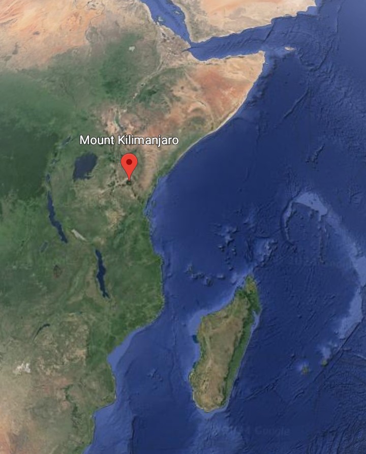
There is a similar ridge structure on the floor of the Arctic Ocean from the present north pole. These structures tend to form around poles, if the pole is in a sea, because the spin of the earth pulls magma to the surface along periodic longitudinal lines which run from pole to pole and so meet at the poles to form such ridge structures.
The centrifugal force of the earth's rotation also tends to pull magma to the surface along the equator. It is fairly east to see such a line of emergence along the earth's equator. The broad Amazon Basin along the equator in South America extends eastward along an east-west section of the Mid-Atlantic Ridge, known as the Romanche Trench. The emergence along the equator then continues eastward as the Congo Basin of Africa, and Lake Victoria in the mountains to the east of that. Mountain lakes are not unusual. but it requires some special explanation of why the second-largest body of fresh water in the world is a mountain lake because they are usually very limited in scope.
This line of magma emergence along the earth's present equator is easy to see. Kilimanjaro is not on this line, but if we look at a line from the end of this line at Lake Victoria to the former south pole as the undersea ridge structure around Madagascar, we see that Kilimanjaro lies right on that line. This is why Kilimanjaro formed where it is, a longitudinal line of emergence from the former south pole which retained emergence activity after the poles shifted, because geology changes very slowly, and was activated by the line of emergence along the equator of the present polar era.
We can see on the map an emergence line of lowland valley from Kilimanjaro down to the coast and pointing at the former south pole as the undersea ridge structure around Madagascar. Like many volcanic mountains, Kilimanjaro has multiple peaks, and those peaks are aligned along this line of emergence from Lake Victoria to the undersea ridge structure around Madagascar.
The volcanic peaks of Kilimanjaro are aligned along a line from Lake Victoria, which is formed by magma emergence along the present equator, to the undersea ridge structure around Madagascar.
Kilimanjaro's position can be explained in the same way as Mount Ararat, the line of emergence system brought magma to the surface but the nearby high terrain hindered the formation of a broad valley. So, at the point of greatest emergence, magma piled up to form Kilimanjaro. The line of emergence probably existed before Africa later moved over it tectonically. Remember that lines of emergence tend to show as ridges along the seafloor but as broad valleys on land because the emerging magma from below spreads the land apart to form the valley.
There is another former longitudinal line of emergence in the area which points toward the former south pole. The elongated Lake Turkana In Kenya, and the lowland valley continuing from it, points directly toward the former south pole which we see as the undersea ridge structure around Madagascar.
Finally, look closely and you can see a string of volcanic islands, known as the Comoros, extending from where the border of Tanzania and Mozambique meets the coast to the former south pole. We have seen in the rest of this theory how many lines there are, in various places, which points to this former south pole around Madagascar.
63) THE MYSTERY OF MONT ST. MICHEL
One of the wonders of the world is surely the rocky island of Mont St. Michel, the site of a medieval monastery, just off the Normandy coast in northern France. But how could it have possibly have come to be? It is much too big to be a glacial erratic and too small to be a volcano.
My conclusion is that Mont St. Michel formed in a way similar to that which formed northern Scotland as described in the section, "Other Lines Of Emergence" and the subsection, "Britain And Northwestern Europe". This also involves "The Original Impact Line".
In the section of the main posting "The Original Impact Line", I explained why I believed The Mediterranean island of Corsica and the Massif Central of southeastern France were fragments of the Original Impact Line, which was the rocky debris from the Continental Asteroid which impacted and moved across the earth's surface. The mountainous northern part of Scotland is also a fragment of this line, moved to the northwest by later tectonic movement. The reason that this part of Scotland is split along the straight line of Glen Mor is that it impacted one of the longitudinal lines of emergence which run north-south, from pole to pole, as represented by the Pennine Mountains.
I wonder if any readers have noticed that the two largest Channel Islands, Guernsey and Jersey, form a straight line with Mont St. Michel, which is located where the French peninsula hosting the city of Cherbourg, the Contentin Peninsula, intersects, at a right angle, the east-west peninsula of Brittany. Not only that, but this straight line can also be extended to include the high terrain of Dartmoor in Devon, in England. If we extend the line in the opposite direction, to the southeast, we find that it is also a perfect straight line through the Massif Central and to Corsica. Furthermore, to the northwest, the straight line brings us to small rocky islands Lundy Island and Skomer Island, just off the southwestern tip of Wales.
I will tell you that all of my experience with natural history tells me that straight lines like this do not occur by chance. I believe that this is a line of fragments of the Original Impact Line as a large piece of it moved gradually northwestward with the tectonic movement of the land beneath, driven by the centrifugal force of the earth's rotation, after the western end of the Original Impact Line was shattered by the comet impact that also formed Italy.
My impression is that the high terrain of Dartmoor, in Devon, is a fragment of the Original Impact Line that broke off as the piece of the line passed a fixed geological feature that was of magma emergence origin, and so would not be moving tectonically along with the land. In the subsection "The Original Impact Line", under the section "Other Lines Of Emergence", we saw how the nearly parallel peninsulas of Brittany in France and the one terminating at Land's End in England are such non-tectonic emergence features. This is in a very similar way that a piece of the section of the Original Impact Line that would form what is now mountainous northern Scotland broke off to form the North York Moors as it collided with the north-south line of magma emergence represented by the Pennine Mountains.
This line from Corsica through the Massif Central and all of these islands leads to southern Ireland. Look at the set of parallel peninsulas in the far southwest of Ireland, out to sea we can see that these peninsulas point to a broad valley in the shallow sea floor that looks just like a line of magma emergence spreading the submerged land apart. These parallel peninsulas look just like those of the Peloponessus, the southern third of Greece, and we know that it is a piece of the Original Impact Line positioned over a line of magma emergence which formed the peninsulas there.
This is the process that I refer to as tridentation, the spreading apart of a piece of the Original Impact Line by an emergence line beneath it. We can see that there is a long peninsula extending from north Wales, the Llyn Peninsula, along exactly the same axis as the parallel peninsulas of southwestern Ireland, and it was held against the same line of emergence.
The peninsula in Normandy, the Contentin Peninsula, hosting the city of Cherbourg, forms a line along the axis of the Pennine Mountains in England, to the north. This peninsula is not mountainous at all. It cannot be explained why this peninsula exists except that it is based on magma emergence in the same way as the Pennines, and this foundation gave it extra resistance to the ice age glaciation which carved the English Channel.
It is right at the intersection of this Contentin Peninsula hosting the city of Cherbourg and the peninsula of Brittany, both of which were based on magma emergence and thus do not move tectonically, that Mont St. Michel is found. This could not be a coincidence either. We know from the formation of the north of Scotland and the North York Moors that if a segment of the Original Impact Line, moving tectonically with the surrounding land, collides with a non-tectonic emergence feature, it can cause pieces to break off of the segment of the Original Impact Line as well as the emergence feature.
This accounts not only for the line of pieces extending northwest from the intersection of the Contentin Peninsula, and the peninsula of Brittany, that begins with Mont St. Michel which lies right at the intersection, but also for Ireland itself. The low mountain terrain of southern Ireland could well be a section of the Pennine-Cherbourg Line that was broken away by the tectonic movement and carried to the northwest and the much higher mountain terrain of northwestern Ireland could be the remaining pieces of the original Impact Line that was carried along and that collided and dislodged the missing section of the Pennine-Cherbourg Line. The lowland middle section of Ireland, with it's limestone base, would have been formed when there was relative movement of the two mountainous section of the country, forcing upward the seafloor between them so that it today forms dry land.
If we look at a large-scale map, we see that the north-south line of the Pennines in England forms a straight line with the section of the Mid-Atlantic Ridge in the south Atlantic Ocean. This shows the Pennines to have originated as a line of emergence over which the land eventually moved tectonically. On the adjacent seafloor, we can see traces of how what is now the northern Mid-Atlantic Ridge shifted westward to avoid the encroaching land because it is obviously easier for magma to emerge on the seafloor, where it is not blocked by land. The Pennine line seems to have curved westward, due to the impact of Scotland.
64) THE MYSTERY OF MOUNT ARARAT
I was reading a religious publication when something really caught my attention, not about religion but about geology. There was a photo of Mount Ararat which showed the wide and flat valley adjacent to the mountain. I got to wondering not just how such a broad valley came to be adjacent to a dormant volcano, such as Ararat, but also why a volcanic mountain was in the midst of mountains that were not volcanic. I decided to investigate further.
One does not have to be Armenian to consider Mount Ararat as sacred. The mountain is on the Turkish side of the border but is a prominent sight from the city of Yerevan, on the other side of the broad valley. This mountain is identified in the Book of Genesis as where Noah's Ark came to rest, and is thus very important to Christians, Jews and, Moslems.
Numerous attempts to find any remains of the ark have proven futile. My opinion is that, first of all, the Bible states "mountains of Ararat", which is plural rather than singular. The ark count have come to rest anywhere in the area, and not necessarily on Ararat itself. Furthermore, the ark was made of wood and even the hardest of woods simply do not last for thousands of years unless shielded from the elements in a very dry climate such as in a tomb. Finally, remember that Ararat was once volcanic. This makes it logical that if the ark was left on Mount Ararat, that it's remains have since been buried under lava.
The great flood is easy to explain. If an ice age ended relatively quickly, with rapidly melting glaciers, it would account for the tremendous deluge of water. Mesopotamia is today a warm climate, but the preponderance of nearby mountains would hold glaciers that would melt when the climate grew warmer.
The second chapter of the Book of Genesis describes four adjoined rivers, of which the Euphrates is one. But today that is not the case, we see only the Tigris and Euphrates merging into the Shatt-al-Arab and then emptying into the Persian Gulf. But this is easily explained also, by citing the example of Niagara Falls.
When the glaciers of an ice age advance southward, pulled by the rotation of the earth, they typically obliterate the drainage pattern of the land until it forms anew after the end of the ice age. As we see at Niagara Falls, and as described in my writing about the natural history of the area on the Niagara blog, there was a river congruent to the present Niagara River in the warm period before the last ice age that is referred to as the St. David's River. This river was filled in by the tremendous amount of soil, rock and debris that was carried by the glaciers.
The present Niagara River does not follow exactly the same course as the former St. David's River. The whirlpool formed because that is where their paths intersected. In the Niagara Area, the broad dip in the road level of the Queen Elizabeth Way (QEW) opposite the Ontario village of St. David's is what remains of the former river. This example of drainage patterns being obliterated by ice age glaciers, but then forming anew explains why the account of the rivers in Genesis is not exactly the same as we see today.
The broad valley on the Armenian side of Mount Ararat appears very much like a typical line of magma emergence on land.
To review, the spin of the earth causes magma (molten rock) to emerge from below along periodic longitudinal lines extending from pole to pole and also along the equator. The reason for the longitudinal lines of emergence are to balance the equatorial emergence in a perpendicular direction, in accordance with the rules of fluid dynamics. The rotation of the earth causes this to usually take place along lines, rather than at a point, but if magma is especially concentrated at some point there can be such point emergence which we refer to as a volcano. These lines of emergence are not neatly placed along lines of longitude and the equator because the poles have shifted because of the added mass of Continental Asteroids landing and also because of distortion due to the added mass of these asteroids on the earth's surface.
Turkey and Iran are most likely the two most mountainous countries on earth. These mountains are not volcanic but Ararat is located among this vast mass of mountains. There was a line of emergence crossing the area, the one curving off the major line running east-west through the central axis of the Black Sea, and this intersected with another such line, the one through the northeastern Mediterranean which formed the long arm of land in that direction extending from the island of Cyprus through the Gulf of Alexandretta, which is at the very northeastern corner of the Mediterranean.
We know that there is likely to be more magma emergence where two lines intersect and that such emergence forms ridges on the sea floor, with possible islands at intersections, but low and broad valleys, or possibly lakes, on land.
Mount Ararat is at exactly the point where this line along Cyprus and through the Gulf of Alexandretta intersects the line of the broad valley adjacent to Ararat, which represents the line of emergence which curves off the major line of emergence through the main axis of the Black Sea.
What happened is that the mountains all around, which are non-volcanic, hindered the emergence of the magma at the intersection of these two lines of emergence so that the magma piled up to form Mount Ararat. There are actually two mountains at Ararat, the smaller one being Little Ararat, with the line between the two running exactly parallel to the adjacent valley on the Armenian side of the mountain.
On the map of eastern Turkey, the line to Ararat from Cyprus and the Gulf of Alexandretta can also be seen in the alignment of two lakes. Moving to the northeast across Turkey, we first come to Ataturk Baraji. Next, we come to a larger lake called Lake Van and you will notice that the long northeastward extension of this lake points directly at Mount Ararat. That is because these two lakes are formed as emerging magma spread the mountainous landscape apart somewhat to create the low areas in which the lakes formed.
Across northern Turkey there is a broad valley through the mountains which, unfortunately, I am not able to find the name of. The valley hosts towns, from northwest to southeast: Tasova, Erbaa, Resadiye and, Akincilar. The valley looks like a definite line of emergence both in the satellite imagery and in photos on Google Street View at ground level.
Notice that this valley through the Turkish mountains points directly at Lake Van, and there is an extension to the lake along this axis as well. We can thus conclude that Lake Van is a low area amid the mountains which formed by the intersection of the two lines of emergence, the one from the broad mountain valley and the other through the Gulf of Alexandretta to Mount Ararat. (The shape of Lake Van, with these arms extending from it, may remind Ontario readers of Lake Simcoe, north of Toronto).
Notice also how the line of emergence represented by the broad valley through the mountains turns off the Black Sea in exactly the same way as the line which forms the Sea of Azov and the low mountains on the Crimean Peninsula, and extends across the Ukraine and Russia that we saw in the main posting. While the line of emergence between them continues along the main east-west axis of the Black Sea and then curves southward to form the line of the broad valley that can easily be seen extending through Georgia and then forming the southern portion of the Caspian Sea and the lowlands to the south of it.
The line of emergence that forms the valley adjacent to Mount Ararat, on the Armenian side of the mountain, is another line which curves off the main line through the basin of the Black Sea and then through Georgia and the Caspian Sea. The line can be seen to extend southward, forming Lake Urmia in Iran.
It seems that these two lines, the one through Lake Van from the broad valley through the mountains in the north of Turkey off the Black Sea and the one off the Black Sea further east which forms the valley adjacent to Mount Ararat and Lake Urmia, then merge together further south into the Tigris-Euphrates valley of Mesopotamia.
The length of the Caspian Sea is itself a longitudinal line of emergence. Aside from it's much deeper southern portion being the product of the line through the Black Sea and Georgia, have you noticed how the lengthwise axis of the Caspian Sea points through the Persian Gulf, which is an extension of the Tigris-Euphrates Valley across Mesopotamia that we know is a line of emergence, and then the lengthwise axis of the Caspian Sea points directly at the ridge structure around Madagascar which I identified as the former south pole.
Once again, longitudinal lines of emergence extend from pole to pole except for the immediate area of the pole where the spin pushes the magma back to form such a ridge structure in the same way that we can see on the floor of the Arctic Ocean around the present north pole.
65) THE IMPACT THEORY OF EUROPE
The Original Impact Line is the extensive line of mountains and high terrain across the eastern hemisphere of the world. This line can be seen to extend from Greece and the Balkans, through Turkey and Iran to the extensive high land of the Central Asian Plateau, including the Himalayan Mountains. My theory is that the only practical way to explain this line is that it is the impact debris from the impact of a Continental Asteroid.
This is an asteroid (actually, there were three) which collided with the earth. Much of the debris from the impact was hurtled back into earth orbit, where it later coalesced by gravity to form the moon. The site of the impact was Antarctica, which explains why this continent has the highest land elevation by far of all the continents. The asteroid hit the earth at an angle and the Original Impact Line extended across the earth from Antarctica until it was broken away by tectonic movement, driven by the rotational force of the earth.
We can see on a map how the Original Impact Line was likely torn from Antarctica. The southern tip of Greenland fits perfectly with the Ross Sea in Antarctica. In another place on the continent, a section was torn away from Antarctica, leaving the jagged line of mountains as a peninsula and the adjacent Weddell Sea. The Central Siberian Plateau is exactly the same size and shape as the Weddell Sea, making it look like a chunk that was pulled out of Antarctica. This is very likely where the Original Impact Line was pulled away from, and it drifted tectonically over countless millions of years to it's present location to form the geological backbone of Asia.
This theory answers so many questions but there are still remaining questions, particularly about the area of Europe.
Why did a long section of the Original Impact Line later break away and move far to the north, as in the case of the Scandinavian (Kjolen) Mountains? Nothing like this is seen anywhere else. It can be seen on a map how the long and extensive chain of mountains through Scandinavia, eastward to the Kola Peninsula of Russia, seem to be a section of the Original Impact Line that once extended westward from Greece and Turkey but was broken off and driven to the north.
Why is there fragments of the Original Impact Line, forming various islands and small land masses, but which are seen only in Europe?
It is fairly certain that the water on earth came from one or more comets. But is there any evidence to be found of where on the earth such a comet might have landed? Italy is unique in that it is a tight loop of volcanic land, with no other volcanic lands anywhere around. How else could it's existence be explained other than magma emergence from the earth below as a result of an impact from space in what is now the Tyrrhenian Sea?
But now, my though is that this is where one of the comets (if there was more than one) landed which provided the water on earth. A comet is basically ice. A sphere of ice that would provide all of the water on earth would be about 1,000 miles (1,609 km) in diameter, too wide for the Tyrrhenian Sea impact and much larger than the average comet nucleus. But the comet could have broken apart before impact and may not have been the only comet which impacted earth.
(By the way, the reason that a comet has a tail is that the radiation from the sun vaporizes some of the ice as the comet comes near to the sun, and the stream of particles from the sun pushes the vapor in the opposite direction. The tail of a comet always points away from the sun).
The geographic shape of the Tyrrhenian Sea just looks so much like some type of impact site, which caused magma to emerge from the earth below to form Italy, Sicily and, Sardinia. Three periodically active volcanoes remain today from this abrupt forcing upward of magma by impact: Mounts Vesuvius, Etna and, Stromboli. If the comet broke apart before impact, we see that the apparent line of impact in the Tyrrhenian Sea leads on to the extensive area below sea level in northern Egypt, known as the Qattara Depression.
Why would there be a tight loop of volcanic lands around a small sea, with no other volcanism anywhere in the area? Unless it was caused from magma emergence due to a comet impact.
This explains why there is no apparent impact debris in the Tyrrhenian basin. It is because it was a comet composed of ice, rather than an asteroid.
Magma emergence lines in the area, as described in the theory, are another factor in final shape of Italy. Sardinia formed by magma emergence by the force of the comet impact against the nearby longitudinal line of emergence which extends northward along the Rhine Valley in Europe. The French island of Corsica is also on this line, but it is a fragment of the Original Impact Line that came to rest against the Longitudinal line of emergence and not the result of magma emergence.
Corsica is a fragment of the Original Impact Line that was broken by the comet impact. The mountains of Sardinia and mainland Italy tend to appear rounded and elongated, typical of volcanic mountains from magma emergence. Those in Corsica appear entirely different, higher and with sharper peaks.
The peninsula of mainland Italy is the result of magma emergence between the comet impact zone and the emergence line of the Adriatic Sea, on the opposite side. The southwest coast of Sicily forms such a straight line because it is from the comet impact against the emergence line which is represented by the broad valley across northeastern Spain, which hosts the city of Zaragoza, which forms the Balearic Islands where it intersects another emergence line which is an extension of the Po Valley across northern Italy, and which ultimately points to the former south pole as it transitioned across the Indian Ocean from it's one-time location as the undersea ridge structure around Madagascar. Notice how the southward extent of the island of Sardinia is also against this line.
The three circular Italian lakes to the north of Rome are not sinkholes, being far too deep and this is not the kind of limestone terrain where sinkholes are found. They are effectively from "bubbles" of water caused by rapid magma emergence.
The Tyrrhenian impact site is due west of the apparent terminus of the Original Impact Line at Greece and Turkey. The comet landed right on the Original Impact Line and broke a section of the Original Impact Line loose, and also broke some of the line into the fragments such as Corsica, and numerous other rocky islands and features that are found in western Europe.
A section of the Original Impact Line was torn away by the force of the impact and shifted westward and northward. This section is Greece and the triangular-shaped Balkan Mountains, extending as far northward as Trieste. This does not include the adjacent Carpathian Mountains, in Romania, which are emergence mountains.
This section that was torn away as the Scandinavian Mountains, which were once joined to the Balkan Mountains around where the far north of Finland and the Kola Peninsula is now located, were driven tectonically northward. The gap from the section that was torn away is the Aegean Sea. How else can this configuration be explained? Greece and Turkey fit together like pieces of a puzzle.
Greece was torn away and displaced to the west, relative to the line of the Balkan Mountains, about the same distance as the width of the Aegean Sea. How else could this arrangement of Greece and the Balkan Mountains come to be? The Sea of Marmara, in Turkey adjacent to Istanbul, is likely the result of an emergence line because it is perfectly in line with the lengthwise axis of the Red Sea. If we continue the axis of the Red Sea, it brings us right to the Sea of Marmara.
We can see how jagged with rocky islands is the Croatian coast, along the Adriatic Sea as far north as Trieste, and also the jagged Aegean Sea area is because was these areas were torn away by the impact. The Balkan Mountains came to rest against the Carpathian Mountains of Romania, which are emergence mountains and not involved in this impact scenario. This possibly stopped the Balkan Mountains from being moved any further. This explains why there was oil deposits in Romania, because the tectonic movement forced rock strata upward, creating pockets where oil could collect over millions of years.
Multiple fragments of the Original Impact Line that were broken off when the comet landed on it, and moved away tectonically, include the island of Corsica, the Massif Central plateau of southwestern France, possibly the Exmoor and Dartmoor plateaus in England, the northern part of Scotland which broke in two along the straight line of Glen Mor when it collided while moving tectonically with the longitudinal line of emergence represented by the Pennine Mountains, northern and southern Ireland and likely the coastal Normandy island on which Mount St. Michel is built as well as the several small English and Welsh rocky islands along the same geographic line.
Corsica is a fragment of the Original Impact Line that collided with the same longitudinal line of emergence along which Sardinia formed by magma emergence, the line represented on land further north as the Rhine Valley, and came to rest along that line. This is similar to the case of Scotland, which collided with a parallel line of emergence, that of the Pennines. But the impact of Scotland, unlike Corsica, caused it to break in two along a straight line, which can easily be seen on a map.
There are rocks like this all around western Europe, that are not of volcanic origin. Where could they have come from, other than as pieces of the Original Impact Line that was shattered by a comet impact.
Notice that the line of the Balkan Mountains, along the Adriatic Sea, points directly to northern Scotland, which is the northernmost of the small fragments. In Ireland, two fragments moving relative to one another forced up the limestone seafloor in between them which is what gives the country it's limestone soil.
An interesting phenomenon is the creation of several parallel peninsulas that takes place when a piece of the Original Impact Line becomes positioned over an emergence line. There are three notable places in Europe where this is seen; the Peloponessus, Thessaloniki and, the southwest of Ireland. This creation of parallel peninsulas when a piece of the Original Impact Line becomes positioned over a line of magma emergence, so that the piece of the Original Impact Line is spread apart, is what I refer to as the process of tridentation. I can see only four examples in the world-the Peloponnesus which is the southern third of Greece, further north in Greece at Thessaloniki, southwestern Ireland and Baffin Island in northern Canada.
The Peloponessus is an ideal example of the process of tridentation, caused by a line of emergence under a continental mass, that spreads the mass apart into, usually, three parallel peninsulas.

The jaggedness of the coast of northernmost Norway is because that is where bending of the mass took place. The flat plain across northern Germany and Poland is where seafloor was forced upward as the Scandinavian Mountains were driven northward by tectonic movement.
The Baltic Shield is to the south of the Scandinavian Mountains. It is roughly similar in concept to the Canadian Shield which is the layer of dense rock underlying approximately the eastern half of Canada. The Canadian Shield is centered around Hudson Bay while the Baltic Shield is centered around the Gulf of Bothnia, the stretch of sea between Sweden and Finland. But where Hudson Bay was formed as it was on the transition route of the north pole, from it's previous location as the Great Basin of the western U.S. to it's present location, the Gulf of Bothnia is an emergence line and this can be seen in that it has a lengthwise axis. This is the emergence line that extends to the southwest through the Skaggerak, The Wash on the east coast of England and, the Bristol Channel.
The weight of the section of the Original Impact Line which moved tectonically across it, the Scandinavian Mountains, brought the magma emergence which formed the rock of the Baltic Shield. The section of the Mid-Atlantic Ridge that is halfway between northwest Africa and the northeastern U.S. and eastern Canada and that is an amalgamation of the first and second equators, that are described in the theory, and that cross Britain can be seen to extend along the line of the lengthwise axis of the Gulf of Bothnia. The Baltic Shield was depressed by the great weight of glacial ice, coming down off the Scandinavian Mountains during the ice ages, to form the shallow area of water known as the Baltic Sea.
Is there any other way to explain how so many physical features on the map fit together in a neat explanation?
65b) THE ALPS AND THE IMPACT THEORY OF EUROPE
I have concluded that the Alps Mountains in Europe could not exist as they do unless they had been high and rocky terrain to begin with. The tectonic impact of Italy with Europe, with pressure from Africa to the south, could not have formed the Alps, as they are, alone.
We saw my scenario of one of the comets (if there was more than one) that brought water to the earth, impacting right on the Original Impact Line so that it not only shattered a section of the Original Impact Line, but created the volcanic lands of Italy, Sicily and, Sardinia by forcing magma from below upward. Tectonic movement northward, driven by the rotation of the earth, supposedly later drove Italy into southern Europe to form the Alps as collision mountains.
But my reasoning is that the Alps are too high and too extensive to be the result of such a collision alone. There was actually a major piece of the Original Impact Line that Italy collided with to form the Alps, but which was already high and rocky terrain to begin with. Prior to the impact, this piece was likely similar to what is now the Massif Central, the nearby high plateau region of southeastern France, which is also a piece of the Original Impact Line. The movement of the piece of the Original Impact Line which is now the Alps forced up seafloor to the north, which now comprises the flat lowlands of northern Europe.
What is now Greece, and the Balkan Mountains to the north, was torn away from the rest of the Original Impact Line by the force of the impact. We know that when a piece of the Original Impact Line undergoes movement, that it forces up seafloor to form flat limestone terrain (known as Karch terrain). The legacy of this is seen today in the valleys of Greece and the limestone used to build ancient buildings and monuments such as the Parthenon.
The geological core of Europe is this extensive piece of the Original Impact Line, with which Italy collided with tectonically to form the Alps, and which movement forced up seafloor to the north to form the flat lowlands of northern Europe. Aside from the Alps evidence of the collision is seen in marble in northern Italy, which is limestone from seafloor that has been forced upward and then undergone the extreme pressure of a tectonic collision.
(Note-An interesting thought occurred to me. If the earth were as large as Jupiter, and all of these geological activities took place, marble might have been a gem that would refract light. See "The Scale Of Gem Formation", on this blog, for details of the reason why. Basically, the earth is not large enough to apply geological pressure precisely even enough to line up the atoms in the marble in neat rows so that light could pass between the rows).
The Alps actually have a lot in common with the Himalayas, on the other side of the world. The Himalayas were formed when India collided tectonically with Asia. The Himalayas are the highest mountains in the world simply because the terrain that it collided with was high already, the Central Asian Plateau which is a prominent part of the Original Impact Line. The Original Impact Line can be seen on a physical geography map as the long line of high and otherwise difficult-to-explain mountains extending across the eastern hemisphere from Greece and the Balkans, through Turkey and Iran to the Central Asian Plateau and beyond to the Kolyma Range of Eastern Siberia.
In photos, it is difficult to tell the difference between the Alps and the Himalayas. A lot of filming by India's movie industry (Bollywood) is actually done in Switzerland, using the Alps as a stand-in for the Himalayas. The form of mountains in both ranges indicate a violent collision because both were formed not by one collision, but by two, first the landing of the Continental Asteroid on earth and then the tectonic collision. Both ranges of mountains resemble a concrete building demolished by a wrecking ball, and then dumped in a pile, at least in shape and forms of the mountains. One notable feature of mountains in both ranges is their exceptionally sharp peaks, which indicate the double impact of their formation.
The geologic essence of India is the Deccan Plateau, which is a piece of one of the Continental Asteroids, and which comprises approximately the southern half of the country. North of that is mostly seafloor forced upward by the tectonic movement of the plateau, and some volcanic origin. North of that is the Ganges Plain, adjacent to the Himalayas and across the northernmost part of the country which is a broad line of emergence that formed just south of the Original Impact Line.
Let's compare the Alps with the Pyrenees, the range of mountains between France and Spain, which were also formed by tectonic collision and which are not far from the Alps. Both are collision ranges that were formed in about the same way. But the Alps are much more extensive, even though Italy is not more massive than the Iberian Peninsula (Spain and Portugal) which collided with France to form the Pyrenees. I find that this requires some special explanation since, if the Alps were formed by the collision of Italy with Europe alone, the scale of the range should be roughly similar to that of the Pyrenees.
But not only are the Alps much more extensive, they are also far higher than the Pyrenees. The highest peak in the Alps is nearly 1.5 km higher than the highest peak in the Pyrenees. In fact, there are well over a hundred peaks in the Alps higher than the highest peak in the Pyrenees. If the Alps formed by the tectonic collision of Italy with Europe alone, as did the Pyrenees, then why are the Alps so much higher and more extensive than the Pyrenees and are more like the Himalayas?
As for the Pyrenees, the geologic essence of Iberia (Spain and Portugal) is a piece of a Continental Asteroid spread apart into broad valleys in several places by magma emergence lines beneath. The geologic essence of France is the Massif Central, the high plateau region in the southeastern part of the country. This is a fragment of the Original Impact Line, which was broken off by the impact of the comet in the same way as the piece which now forms the Alps. The movement of this piece forced seafloor upward to the north and west. The Rhone Valley is a section of magma emergence line, between the Massif Central and the Alps, which was broken off the Rhine Valley, to the north, by the tectonic impact of Italy and the resulting movement of the fragment of Original Impact Line which is now the Alps.
I think that it is safe to conclude that the terrain of which the Alps Mountains were formed was high and rocky terrain to begin with. If we compare the Alps with the Pyrenees, we see that the Alps could not have been formed by the tectonic collision of Italy with Europe alone. It fits perfectly that the Alps are formed of a piece of the Original Impact Line that was broken off by the impact of the comet, which formed Italy and nearby islands, with the line. This is why the Alps look so much more like the Himalayas than the Pyrenees, because the Alps were formed by a double collision-first, the collision of the Continental Asteroid which formed the Original Impact Line with the earth and then a tectonic collision with that line or, in the case of the Alps, a piece of that line.
66) THE IMPACT THEORY OF EAST ASIA
One simple rule of geology is that, if you find that something has occurred somewhere, the next step is to see if something similar might have occurred somewhere else. In "The Impact Theory Of Europe", we saw the likelihood of a comet impact that struck the Original Impact Line and shaped the geology of Europe. I cannot help noticing another place in the world where another comet impact seems possible to have occurred.
How did Korea come to be? It is a mountainous peninsula with the mountains concentrated on the east coast. There is a volcanic element to the rock in the terrain and, Jeju island, in particular, is of volcanic origin. The Korean peninsula is not the result of a tectonic collision. In this I see a very close parallel to Europe.
It is fairly certain that the water on earth came from comets, which are basically a ball of ice. When the comet nears the sun in it's orbit, the radiation causes some of the ice to vaporize and trail behind so that the comet appears to have a tail, as this vapor is illuminated by the sun. There is almost certainly too much water on earth to be from the impact of a single comet.
A comet could have struck in what is now the Sea of Japan. The force of the impact would have caused a great amount of magma to have emerged from the nearby plate boundary. The result is the islands of Japan. This would make the Tyrrhenian Sea, in Europe, congruent to the Sea of Japan and Japan congruent to Italy in formation.
A section of the adjacent rocky land mass, which is an extension of the Original Impact Line and makes up mainland Asia, is torn loose by the force of the impact and displaced toward the impact site. This displaced section of rocky land mass is the peninsula of Korea, and this makes Korea congruent to Greece. This movement of Korea would have forced some magma from below up in front of it, and this accounts for the volcanic element in it's rocks. The place where it was torn away from would become a sea. This is the Yellow Sea, between Korea and China, and this sea is congruent to the Aegean Sea.
The Sea of Japan, between Japan and mainland Asia, is deep while the other seas between east Asia and the Pacific Plate, such as the East China Sea, are shallow. Also, as can be seen in the satellite imagery, the floor of the Sea of Japan looks as if there might have been one or two such impacts there. The curve in the east coast of North Korea looks like it could be where the impact might have taken place.
Aside from how the Korean Peninsula could have possibly come to be, how could a country as large as Japan form largely from volcanic magma emergence without some special explanation? There are long lines of volcanic islands along this area of the boundary of the Pacific Tectonic Plate, such as the Aleutians and the Kuril Islands, to the north of Japan. The chain of islands continues to the southwest of Japan as the Ryukyu Islands. There are other islands to the south of Japan, but these are also small atolls and volcanic islands.
But these islands are very small, one can go for a walk right around many of them. Why, then, is Japan so massive, by comparison, if it was formed in the same way? There must be some special explanation, and this comet impact theory provides it. Another interesting observation is that both comet impacts would be at exactly the same latitude.
It is true that there are more lands to the south which were also formed by magma emergence, Indonesia and the Philippines. But the volume of magma emergence which formed these lands is explainable as being near the convergence of all three equators, the present one and the former two. Since the centrifugal force of the earth's rotation causes magma to emerge along the equator, it would make sense that we would find large volcanic islands around the area of the equatorial convergence, just as we do in the islands of the Caribbean on the diametrically opposite side of the world.
But Japan is far to the north, well away from this zone where there are many volcanic islands that are little more than pinpoints. Both the existence of Japan and the configuration of Korea, which are close to one another, requires some really special explanation.
67) THE PROCESS OF TRIDENTATION
There is a large-scale geological process that I have referred to often in this theory, but which I have neither named nor described in detail thus far. I would like to name this process "Tridentation", and describe it's operation today. Tridentation takes place when a piece of the Original Impact Line, or a piece of either of the Continental Asteroids, becomes positioned over a line of magma emergence on the surface of the earth.
Basically the centrifugal force of the earth's spin brings magma to the surface from below, which is hot and molten rock. The rotation also causes this emergence to take place along lines. Although there can be emergence from one spot if there is enough concentration, this is what we refer to as a volcano. This emergence takes place along the equator, and also along longitudinal lines of emergence which run from pole to pole and are perpendicular to the equator.
The thing that gets complicated is that, according to my geological theory, the earth's poles and equator underwent major shifts three times as Continental Asteroids, which today make up the earth's continental mass, landed on the earth. On each occasion, the added mass unbalanced the earth's rotation so that it shifted on it's axis to regain balance. Magma emergence changes very slowly as such shifts occur, with the result that today there are effectively the remains of three sets of lines of emergence shaping the surface of the earth. Remember that these lines tend to form ridges of on the seafloor, but broad valleys if on land as the magma emerging spreads the land above it.
The process of tridentation that I want to explain today takes place when a limited piece of the Original Impact Line, the long trail left by the Third Continental Asteroid across the mountains of Turkey and Iran to the high Central Asian Plateau, or any other limited piece of a Continental Asteroid becomes positioned above a line of emergence. The "shattering" of a section of the Original Impact Line to produce a number of fragments, to which this process can occur, is described in the above supporting document "The Impact Theory Of Europe".
A trident is a spear with three prongs, which used to be used for hunting fish. The reason that I have named this process "tridentation" is that the piece of a Continental Asteroid is always spread into three long and narrow peninsulas by this process. The length to width ratio of these peninsulas usually ends up being about 10:1, with the gaps between the peninsulas being of approximately the same width as the peninsulas.
Here are the examples of tridentation that I see in the world.


1) Greece's Peloponessus. The Peloponessus is the peninsula comprising approximately the southern third of Greece. It is the ideal example of tridentation as a section of the Original Impact Line, torn loose by a probable comet impact as described in the supporting document "The Impact Theory Of Europe", became positioned over the line of emergence represented by the Adriatic Sea which was a longitudinal line of emergence from the second set of poles when the south pole was at the undersea ridge structure around Madagascar and the north pole was the Great Basin of the western U.S.
2) At Thessaloniki in Greece. There is a smaller example of tridentation further north in Greece, the three peninsulas adjacent to the city of Thessaloniki. (If the name of this city seems familiar it is because St. Paul's first letter to the church there, the Thessalonians, was the first book of the New Testament to be written).
3) Southwestern Ireland is composed of three peninsulas of tridentation as a piece of the Original Impact Line, which was broken free, ended up positioned over a remnant emergence line that was abandoned as the Mid-Atlantic Ridge shifted westward to it's present location. Look closely on the satellite imagery on the seafloor to the southwest of Ireland, and you can see an indentation in the shallower water that was also the result of this emergence line.
4) Baffin Island. There is a prominent line of emergence separating Greenland and Canada, and this is what produced the tridentation of Baffin Island. The mountainous islands of the Canadian Arctic are of Continental Asteroid origin.
When a piece of of a Continental Asteroid becomes positioned over a line of emergence, with magma emerging from the center, the part of the piece of Continental Asteroid at the very center will remain where it is because it is solid, rocky terrain that is being pulled about equally from both sides. The Continental Asteroid on either side of the center will undergo a pull more in that direction and will be pulled away from the center in the direction that the magma is emerging. The size scale of the piece and the line do not matter because the process remains the same, and the length to width ratio of the peninsulas will remain about the same.
There is unlikely to be more than three parallel peninsulas if magma is emerging outward in opposite lateral directions from a central line in the line of emergence. I cannot see that there is any tridentation on a seafloor, or under land that is raised seafloor, or on volcanic lands, but only under a limited piece of a Continental Asteroid.
Spain may be a special case of tridentation. There are not the three familiar peninsulas, but the high terrain of southern Spain is separated by three broad valleys, running roughly southwest to northeast and being in line with the former equatorial line of emergence that forms the Po Valley of northern Italy and the Balearic Islands. This may be seen as tridentation that had not gone as far as to form the peninsulas because the land was too massive relative to the volume of magma emergence.
I find that evidence of the theory of all three Continental Asteroids and lines of magma emergence is shown here by how they interact with each other.
68) THE EXTRUSION MOUNTAINS OF SOUTH AMERICA
There are two fabled mountains in South America, Sugarloaf and Manchu Picchu, on opposite sides of the continent. Sugarloaf is on the coast at Rio de Janeiro and Manchu Picchu is in Peru, adjacent to the Andes. Just adjacent to Sugarloaf is Corcovado, the mountain with the statue of Christ the Redeemer at the top. Sugarloaf is not the only mountain or feature by that name, there is a mountain in Wales with the same name.
Notice the unique shapes of Manchu Picchu, in Peru, and Sugarloaf in Brazil. That is because they were produced by the same process that I am describing here.
There are other mountains near Sugarloaf and Corcovado with similar form. Manchu Picchu is the Inca city built on a saddle-shaped mountain, with one right next to it that is of the same form as Sugarloaf and Corcovado, on the opposite side of the continent. All are made mostly of hard granite rock that was extruded from below in the same way as in a plastic mold.
There is a lot more that these famous mountains on opposite sides of South America have in common.
In my theory of how the surface and seafloor of the earth came to have the features and patterns that it does, the earth's poles and equator shifted twice when Continental Asteroids landed on earth. The added mass unbalanced the earth's rotation, and each shift was to regain balance. The mass of the Continental Asteroids forms the continents of today.
Magma emerges from below, on lines across the earth due to the earth's rotation. If magma, hot molten rock, becomes concentrated enough then it can emerge from a spot instead of a line, and this is what we call a volcano. Centrifugal force naturally brings magma emergence along the equator, but this has to be balanced by periodic longitudinal lines of emergence perpendicular to the equator and running from pole to pole. When the poles and equator shift due to the added mass of a Continental Asteroid that has landed, these lines from the previous era before the shift may remain, and show up as ridges if on the seafloor but broad valleys if under land because the emerging magma tends to spread land apart.
Where longitudinal lines of emergence meet at a pole, they tend to form a circular or semi-circular ridge structure such as we can see both to the west of Midway, the former north pole, and the semi-circular ridge structure in the south Atlantic Ocean about 2,000 km southwest of the southern tip of Southern Africa. This, according to my theory, is what forms the earth's surface and seafloor that we see today.
When the poles and equator undergo such a shift, only two lines can remain which were direct longitudinal lines of emergence in the previous polar era. The line across the world from what was the first north pole, seen in the circular seafloor ridge west of Midway Island in the Pacific Ocean, to the first south pole, seen in the circular ridge structure in the south Atlantic Ocean about 2,000 km southwest of the southern tip of Africa, is what I referred to in the theory as the Hawaii-Midway Line because it includes the Hawaiian Islands and the numerous seamounts (undersea mountains) in the line from Hawaii northwest to Midway.
Notice that the Hawaii-Midway Line, on the way to the first south pole to the southwest of the southern tip of Africa, passes directly through the locations of Manchu Picchu, in the west of South America, and Sugarloaf and Corcovado on the east coast of South America. That is no coincidence, the igneous granite rock composing all of these mountains resulted from emergence along the Hawaii-Midway Line.
That is not all. You can see an undersea ridge extending far to the southwest from the coast of Peru, at an angle of about 45 degrees to the cardinal compass directions. I pointed this out in the theory as the line of a former equator. Manchu Picchu, with it's granite emergence mountain, is located exactly at the intersection of this line and the Hawaii-Midway Line. To the northwest, the Hawaii-Midway Line formed the Galapagos Islands where it intersects the present equator.

On the opposite side of South America, the line of the Hawaii-Midway Line can be seen extending off the coast in a southeastward direction toward the former south pole, represented by the semi-circular ridge structure on the seafloor about 2,000 km to the southwest of the southern tip of Africa. The plateau structure some distance from the coast of South America on this line is known as the Bromley Plateau. Sugarloaf, Corcovado and, related nearby mountains are right on this line.
We can also see a line of seamounts (undersea mountains) extending eastward, toward Africa, from the coast just north of Rio de Janeiro. In fact, if we extend the line of these seamounts eastward, we find that this is exactly the line of the southernmost portion of the Great Rift Valley in Africa. The southernmost portion of the Rift Valley, which is really one of my lines of emergence, runs east-west and forms the borders of Namibia, Botswana and Zambia to the south, and Angola and Zambia to the north. This line of the Rift Valley extends onto the seafloor, now to the southwest, as the very prominent Walvis Ridge on the seafloor which leads directly to the former south pole, as the semi-circular ridge structure.
(The Walvis Ridge and southern portion of the Great Rift Valley, by the way, remains as the route that the south pole migrated from the semicircular ridge structure to the southwest of the southern tip of Africa to the location of the second south pole as the ridge structure around the island of Madagascar, known as the Mascarene Ridge, to re-balance the earth's rotation following the impact of the Second Continental Asteroid. At the same time, the north pole was migrating from west of Midway, in the Pacific, to what is now the Great Basin of the western U.S.)
Remember that lines of emergence always "try" to form straight lines, due to the rotation of the earth. This is why this east-west line of seamounts extends off the coast just to the north of Rio de Janeiro. The significant thing is that it is where this line, from the east-west section of the Great Rift Valley, meets the Hawaii-Midway Line that Sugarloaf and Corcovado are found.
The reason that I refer to these as "extrusion" mountains, like the plastic being extruded into a mold to manufacture products, is that much of the continent of South America is actually "squeezed" between the tectonic Pacific Plate boundary, the collision of the continent with which forms the Andes Mountains, and the spreading of the seafloor along the line of the Mid-Atlantic Ridge, which is seen in the satellite imagery as the broad seafloor ridge running the length of the Atlantic Ocean. This "squeezing", along the Hawaii-Midway Line where emergence would naturally takes place, creates these granite mountains with similar form.
69) THE GEOLOGY OF THE MIDDLE EAST EXPLAINED
I would like to add two new geological features to the Original Impact Line and to give my version of the Middle East. This is the rocky debris left from a Continental Asteroid, which collided with the earth. I see it as having formed vast ranges of mountains which are otherwise unexplainable. This collision is not a new idea, some refer to the Continental Asteroid as Theia and use it to explain the moon. I have expanded it to explain the continents as well.
From high up in the satellite imagery, it is easy to see what is known as the Arabian-Nubian Shield. This is the dark area of mountainous rock that is split down the middle by the Red Sea. The famed Nile River essentially curves around the western end of this shield. Other well-known geological shields in the world are the Canadian Shield, the dense layer of rock underlying the eastern half of Canada, and the Amazonian Shield in South America.
The dark areas of rock, on opposite sides of the Red sea, is the Arabian-Nubian Shield.

The two things that have mystified me about the Middle East is how the Strait of Hormuz, on one side of the Arabian Peninsula, and the Sinai Peninsula, on the other side of the peninsula, came to be. Keep in mind that all land on earth is either parts of the Original Impact Line, in my geological theory the remnants of the Continental Asteroid (actually, most likely three Continental Asteroids) which collided with the earth and scattered their rocky mass across the surface to form higher elevation land, or seafloor that is forced upward to form dry land as segments of the Original Impact Line move tectonically when drawn by the centrifugal force of earth's rotation, or is of volcanic origin including coral atolls atop extinct submerged volcanoes.
The majority of dry land on earth today is seafloor which was forced upward by the tectonic movement of sections of the Original Impact Line. The raised seafloor tends to form relatively flat lower terrain, at least until it is eroded away unevenly by millions of years of weather and water. The sections of the Original Impact Line forms high rocky terrain or extensive mountains.
On the floors of seas, the bodies of microscopic creatures builds up over long periods of time until compressed into limestone by the weight of those above and of the water. The pounding of the waves gradually breaks up rock into sand, which is compressed into layers of sandstone on the bottom of the sea. Tectonic movement may force this upward to form land.
As the Arabian-Nubian Shield moved tectonically to where it is now, driven by the earth's rotation before it was split by the Red Sea, a lot of nearby seafloor was forced upward to form land that we see today. Much of the natural scenery in a wide area around the shield is reminiscent of the western U.S., particularly the layers of sandstone visible on cliffs and mountains in Utah. This can be seen in the photos of the area in the map link. The southeastern half of Yemen, at the end of the Arabian Peninsula which used to be the country known as South Yemen or Aden, can be seen as being composed of such former seafloor that has been eroded unevenly over time into various formations which show the horizontal layers of strata.
One of the most amazing sights in the world is the literal sea of sand which covers so much of the landscape of Saudi Arabia outside of the Arabian-Nubian Shield. In the satellite imagery it appears as an ocean with waves of sand instead of water. The Red Sea side of the country isn't very sandy because that is where the shield is. The southern portion of Saudi Arabia especially looks like a sea of sand.
But remember that sand is formed by the sea as the pounding of the waves over long periods of time gradually breaks rock into granules. This means that all of this area of Saudi Arabia and nearby countries are on seafloor that was forced upward by the movement of the Arabian-Nubian Shield.
These countries also hold a significant portion of the world's oil reserves. Oil is also found where land has been forced upward by tectonic movement that forms gaps between rock strata where oil can collect over millions of years. The oilfields of the Arabian Peninsula are found on the side facing the Persian Gulf, and not on the side facing the Red Sea because the Red Sea side is where the Arabian-Nubian Shield is located so that it is the opposite side which would be forced upward by it's tectonic movement.
On the other side of the Red Sea there is also extensive areas of land forced upward by the tectonic movement of the Arabian-Nubian Shield. Extensive layers of strata in sandstone from former seafloor can be seen in Egypt. This is seen more in the Western Desert, to the west of the Nile River, because the Eastern Desert, between the Nile and the Red Sea, is mostly composed of the mountainous rocky terrain of the shield itself. The dark green area around the termination of the Nile at the Mediterranean Sea is the Nile Delta, which has been especially important to history. The lush green terrain here is very flat, and we know that wide areas of flat ground are almost always seafloor that has been forced upward by tectonic activity.
In the Sphinx, we can actually see the layering of the limestone from which it was carved. That means that this is seafloor that was forced upward by tectonic movement.
(Note-One thing that I have looked for in Egypt is the Pharaoh's Canal, which linked the Nile and the Red Sea in ancient times although there is uncertainty about whether it was completed. However, I cannot see that any trace of it remains at least not that can be seen in the satellite imagery).
We have seen how the mountains of Turkey and Iran, on through to the vast high rocky terrain of central Asia, is the largest section of the Original Impact Line. The actual site of impact is Antarctica, which is very high rocky terrain. But we can see how the line of mountains through Turkey and Iran has been pushed northward. This is the result of the collision with the Arabian-Nubian Shield and all of the raised seafloor around it.
But when there is an action, there must also be an equal and opposite reaction and this is as true of geology as it is of physics. It is the movement of the Arabian-Nubian Shield toward these mountains, drawn by the force of the earth's rotation, which forced up the seafloor between them so that it today forms dry land, including much of Egypt. As we saw in 16) "The Creation Of Russia", the northward movement of these mountains also forced up seafloor on the other side to form the vast expanses of flat steppe in southern Russia and nearby countries such as Kazakhstan.
What about the fabled Sinai Peninsula, at the northwestern end of the Red Sea, through which Moses led the Israelites? How could it possibly come to be in geological terms? If we take a close look at it in the satellite imagery we see that the answer is simple in light of the nearby Arabian-Nubian Shield.
The southeastern section of the Sinai is the part that is really mountainous. This is a piece of the Arabian-Nubian Shield which broke off and was carried by tectonic movement. Looking closely at the terrain of the Sinai, we see that just outside the very mountainous terrain of the southeast, there are rock formations with strata pointing at all manner of angles. this is former seafloor that was first forced upward to become land and then shattered by further tectonic movement. In fact, I see the Sinai as a kind of miniature example of this entire scenario involving the Arabian-Nubian Shield.
There is another piece which broke off, similar to the Sinai, to be seen across the border of Jordan and Syria to the south and east of Damascus. It is pressure westward by this piece of the Arabian-Nubian Shield which goes into raising the mountains of Lebanon due to the former seafloor being caught between pressure from this piece and the tectonic plate boundary represented by the Mediterranean coast.
Socotra Island is one larger and three small Yemeni islands in the Gulf Of Aden, at the southern end of the Red Sea. These also appear to have been pieces which broke off the main section of the Arabian-Nubian Shield. The larger island is much higher in elevation on the eastern side, and the lower western side displays rock structures with the horizontal strata of seafloor that has been forced upward. My conclusion is that this island also results from the higher undersea terrain which comes from being at the intersection of two very prominent lines of emergence.
The Arabian Peninsula, consisting of the land created by raised seafloor around the Arabian half of the Arabian-Nubian Shield, the section east of the Red Sea, collided with the tectonic plate boundary represented by the eastern coast of the Mediterranean, which is also referred to as the Levant. The line of magma emergence running north-south through Israel, which can be seen on a map as including the Dead Sea and the Sea of Galilee, is actually created by magma emerging through the gap between the two tectonic plates along this plate boundary. (In ancient times, the Sea of Galilee was called Lake Chinnaret).
It was the collision which raised the mountains all along the coast, in both Lebanon and Syria. The Bekaa Valley of Lebanon, well-known for it's agricultural produce, is reminiscent of the valleys in California resulting from lines of emergence. Some salt water was trapped as the seafloor rose suddenly and it collected in the lowest part of this plate boundary to form the Dead Sea.
The force of the collision further south, in Israel, went into raising more seafloor. This is seen today in the sandstone cliffs into which the ancient buildings of Petra, in Jordan, are carved. It also created limestone cliffs. Remember that limestone, which originally forms on seafloors, is eventually dissolved by flowing water. This can create sinkholes, if it is under the ground, or caves if it is in a cliff. Limestone can recrystallize after being dissolved in water to create the ceiling formations in caves known a stalactites.
Such limestone caves in Israel can be seen in the Bible story, such as when Saul was in pursuit of David, and later in the storing of the Dead Sea Scrolls. The tomb of Jesus was also cut out of rock, and this could only be limestone or sandstone. Cement, which is a mixture of limestone and clay, takes advantage of this ability of limestone to dissolve and recrystallize.
What about the coastal range of mountains on the north coast of Somalia, adjacent to the Gulf of Aden? Notice how similar they are to the range along the Levant, the east coast of the Mediterranean, in Lebanon and Syria. That is because this is also a plate boundary here and the mountains were formed by collision with it, and this shows the direction from which this land mass must have come.
The Red Sea divides the Arabian-Nubian Shield in half, but it does not extend far enough south to divide all of the land around it, created by raised seafloor. The Red Sea is also a plate boundary and prominent line of magma emergence, but continues only as far south as the Gulf of Aden. The north of Somalia is a section of this which remained on the African side because it was not cut over to the Arabian side.
What about the Strait of Hormuz, on the other side of the Arabian Peninsula, opposite Iran? How could this feature possible have formed? It looks like the U curve in the drain of a kitchen sink. But this is readily explained by the lines of magma emergence across the world. The strait is actually an intersection of lines of emergence.

The satellite imagery shows that the mountains of Iran actually curve around the strait. But notice that this curve is in line with the Caspian Sea to the north and also the relative lowlands in eastern central Iran. The curve in the Strait of Hormuz on the Iranian side is actually a part of this line of emergence. The Persian Gulf and the Tigris-Euphrates Valley, as it continues onto land, is a second line of emergence. The entrance to the Strait of Hormuz, from the Arabian Sea, is a third line of emergence which approaches the strait but is not in line with the one along the Persian Gulf. Both the second and third line join with the one through Iran to the Caspian Sea so that we are left with this configuration, the emergence line of the Caspian Sea through the Strait of Hormuz points to the former south pole which we saw was the ridge structure around Madagascar.
The Tigris-Euphrates Valley, where so much of early civilization took place, is the continuation of the line of emergence that forms the Persian Gulf, onto land.

If we look eastward, to Pakistan, we see that there is another such line of magma emergence which tried to push upward through the mountains. It is to the west of the broad Indus Valley, which is a plate boundary and line of emergence. There is a large lagoon near the sea in the valley which was created by this line of emergence and the towns of Winder and Uthal are within the valley. The line of magma emergence through the Strait of Hormuz, from the Arabian Sea, is the one through this valley. This valley through Pakistan also points to the former south pole represented by the ridge structure around Madagascar because it, like the one through the Caspian Sea and Iran, are former longitudinal lines of magma emergence which tend to run periodically from pole to pole.
The Indus Valley is a definite line of emergence, as a broad valley amid mountains. On a large-scale map, the Indus Valley forms a straight line with the Walvis Ridge and the smooth coast of east Africa.

(By the way, have you ever wondered how the Caspian Sea came to be where it is with salt water, but cut off from the rest of the world's oceans? This makes the Caspian Sea a much larger version of the Dead Sea. It shows how my Original Impact Line concept is correct. The movement of the section of the line as represented by the extensive mountains of Turkey and Iran, which cannot be explained any other way, cut off a part of the ocean which it today the Caspian Sea. It also cut off the Black Sea, but that does have a narrow outlet to the outside. The east central lowlands of Iran, which are actually high in elevation by low relative to the rest of the country and are in a line with the axis of the Caspian Sea and the Strait of Hormuz, display many of the same eroded sandstone features with the horizontal strata clearly visible which indicate that this was once seafloor that was forced upward by the moving in of the Original Impact Line).
There are prominent mountains along the Arab side of the Persian Gulf, forming the peninsula in the United Arab Emirates and continuing along the coast of Oman. These mountains are actually a part of those on the Iranian side, but were cut away by the line of magma emergence from the Arabian Sea.
We can see traces of when the Arabian land mass collided with Iran, before being pushed apart by the emergence along these lines, in the terrain on both sides of the Strait of Hormuz. Both the very tip of the peninsula on the Arab side and the island in the strait on the Iranian side can be seen in the ground photos with the satellite imagery to be composed of the familiar horizontally-layered strata of seafloor that has been forced upward by tectonic collision.
Aside from the Arabian-Nubian Shield, I have also decided that the so-called West African Craton, there is an article about it on Wikipedia, must have been directly from the Continental Asteroid impacts, likely the first one. I have written already that the southern part of Africa is a part of it, and geologists consider that to be made up of three separate cratons. A craton is simply a solid mass of rocky ground which moved tectonically as driven by the earth's rotation and is not simply seafloor which has been forced upward.
Looking around at the satellite imagery and photos which are included, the terrain of much of north Africa is sandy. Especially in Libya, there is a "sea" of sand with waves which resembles that in Saudi Arabia. But there is also so much of the rock formation structures from eroded sandstone layers that eventually result from seafloor being forced upward. Many of these sandstone structures have eroded unevenly to create formations resembling the buttes and mesas of the American southwest. The West African Craton and the Arabian-Nubian Shield moving closer to one another has forced up the seafloor in between.
One final thought about north Africa. What happens to all of the particles of sand which get gradually eroded away from the sandstone layers of the former seafloor which was forced upward across north Africa? Hurricanes form in the Atlantic Ocean as dust from north Africa, including these particles of sandstone, get swept out over the ocean by the wind to act as condensation nuclei for evaporated water from the warm oceans. By increasing the ability of the air to hold water these particles create the massive circular storms known as hurricanes which afflict the western hemisphere, particularly the Caribbean and the U.S.
A question that arises about the geology of the Middle East is how the nation of Israel came to have the geologic configuration that it does. It is a small country, but can be seen by even the casual observer to have very complex geology.
The Jordan Valley is a tectonic plate boundary which extends from the Red Sea, which is another plate boundary, proceeds northward through Israel, and then curves across Lebanon to form the Bekaa Valley until it joins the line of magma emergence of the Tigris-Euphrates Valley, which is not a tectonic plate boundary but is a prominent line of emergence. The Tigris-Euphrates Valley thus illustrates the difference between lines of emergence and tectonic plate boundaries, where there is typically a lot of magma emergence from below.
In Israel the so-called West Bank of the Jordan River, which is usually in the news not for it's geology but for the politics of the Israeli settlements being constructed on it, is a complex of stony hills and valleys which is much higher in elevation than the lower land westward toward the Mediterranean coast. The satellite imagery shows the boundary of the West Bank as a white dashed line because it is a political, as well as a geological zone. The West Bank was formed by magma emerging and solidifying from the plate boundary along the Jordan Valley, just to the east.
High up in the satellite imagery, look at how smooth the coast of Israel is due to being formed by the magma emergence. There is nothing like a natural harbor (harbour). This is why the biblical Israelites showed little interest in seafaring, much unlike both the Egyptians to the south and the Phoenicians to the north. The Philistines arrived from the sea and settled along the coast of what is now Israel, but they landed further north where they destroyed the royal city of Ugarit.

Along the plate boundary of the Jordan Valley, which can be seen as the eastern boundary of Israel runs along it, there are two very well-known bodies of water. To the south is the Dead Sea, and to the north is the Sea of Galilee. Both were formed by points of exceptional magma emergence pulling the land apart. Remember that lines of magma emergence forms ridges on the seafloor, but valleys on land because it tends to spread the land apart as it emerges.
Seafloor was forced upward by this movement and in photos of the famous fortress known as Masada, just west of the central Dead Sea, the horizontal rock strata for former seafloor can clearly be seen. It makes sense that seafloor was forced upward here because the Dead Sea has very high salt content, indicating that it was a portion of the ocean which was trapped by the sudden upward movement and was greatly reduced by evaporation so that the salt in the water became very concentrated.
There are variations in the terrain of Israel for which there is no ready explanation. The northern part of the Dead Sea is far deeper than the southern part. The northern half of the highlands of the West Bank are much more extensive than the southern half. The Dead Sea is adjacent to the less-extensive southern half of the West Bank highlands.
The city of Jerusalem is in the middle of the West Bank highlands, but this is where there was the least magma emergence from the Jordan Valley plate boundary and the West Bank here is narrower than anywhere else. This divides the highlands of the West Bank neatly in half, like a backwards "B", with Jerusalem in the middle. Finally Jerusalem, where there is the least emergence of all along the West Bank highlands, is directly adjacent to the northern limit of the Dead Sea, where it is deepest. I find it also interesting what a straight line the north shore of the Dead Sea is, and how this shore forms a line with the low area west of Jerusalem where there is a broad valley instead of the high terrain like the rest of the West Bank.
There are other mysterious features in the landscape of the region. From high up in the satellite imagery, I was puzzled by the prominent black spot near the southernmost point of Syria to the southeast of Damascus. It turned out that it was the lava field from volcanic cones, known as Es-Safa. There are many photos of it in the satellite imagery.
The black area in the center is the Es Safa Lava Field.

The Es-Safa Lava Field is located within the large roughly rectangular area of dark terrain, straddling the Syria-Jordan border, that I identified as a section of the Arabian-Nubian Shield which broke away and was carried to the northeast by tectonic movement. The mountainous southeastern section of the Sinai Peninsula is another such section. What happened is the piece of the Arabian-Nubian Shield blocked the magma from emerging in the usual lines so that the pressure built up and it broke through in one place, forming this black lava field.
Just to the southwest of the Es-Safa lava field is a much larger dark brown area, in the very south of Syria. This is an elevated volcanic plateau, known as Jabal Al-Druze. In the northern part of this volcanic plateau is a volcanic crater known as Al Maf' Alani at the town of Maf' Aleh.
The Golan Heights, which everyone who has read recent history is familiar with in terms of conflict and politics, is the high terrain that is visible in the satellite imagery just to the east, and to the northeast of the Sea of Galilee. The reason that the most prominent magma emergence here is to the east, rather than to the west, of the Jordan Valley is that the area is caught between this Jabal Al-Druze volcanic plateau and the plate boundary of the Jordan Valley.
At the north end of the Golan Heights we find the renowned Mount Hermon, the highest point in Syria consisting of three peaks. It's location, to the southwest of Damascus, is right where we would expect to find a lot of magma emergence between the Jabal Al-Druze lava field and the Bekaa Valley, the line of emergence along the plate boundary, as the line curves eastward toward the Tigris-Euphrates Valley.
The Bekaa Valley, through the center of Lebanon, is a line of emergence that curves from the line of the Jordan Valley, around to the line of emergence of the Tigris-Euphrates Valley, and from there forms the Persian Gulf.

Remember that the vast dark area that is split approximately in half by the Red Sea leaving half on the Arabian side and half on the African side is the Arabian-Nubian Shield, which is the primary geological component of the area.
The other large dark area in the satellite imagery is another volcanic field which occupies the southern part of the country of Jordan well into Saudi Arabia, and is known as Harrat Ash Shamah. This volcanic field seems to be stretching over a broad area toward where the Tigris-Euphrates Valley continues into the Persian Gulf.
The thing that caught my attention is that not only are the Dead Sea, the Jabal Al-Druze Volcanic Plateau (large brown area) and the Es-Safa lava field (smaller black area) in a straight line, but are also in the line that we would expect of the line along which the magma emerges tried to find a more efficient "shortcut" from the southern Jordan Valley across to the line of the Tigris Euphrates River Valley. Never has the color of the landscape in the satellite imagery played such an important role in my writing on geological natural history.
So, we see that the reason emerging magma went to spreading the land apart to form the Dead Sea, instead of going to build the lesser southern portion of the West Bank highlands, the part south of Jerusalem, is that the line of magma emergence "tried" to take a "shortcut" to the emergence line of the Tigris-Euphrates Valley instead of going the long way around, forming the Sea of Galilee and going through Lebanon to form the Bekaa Valley. The much broader and more disperse Harrat Ash Shamah volcanic field could also be an attempt at a "shortcut". Magma emergence, like electricity or flowing water, seeks the path of least resistance.
This idea of a line of magma emergence attempting a "shortcut" is not at all unprecedented. This is what produced the series of north-south mountain ranges and valleys in the U.S. state of Nevada, which can be clearly seen in the satellite imagery. There was lines of emergence both to the north and to the south, both running roughly east-west, and the valleys and ranges across Nevada were formed by "shortcuts" between them. The line to the north is the broad Snake River Plain of Idaho and to the south is the line represented by the Valley of the Sun, in which Phoenix is located and the Mohave Valley of California.
The broad V-shaped valley extending westward from Jerusalem, making it so that this is the point along the West Bank from north to south where it is by far the narrowest, is actually a part of a line of emergence that is perpendicular to the plate boundary along the Jordan Valley.
Further north, as described in section I) "Other Lines of Emergence", the Valley of Jezreel in northern Israel proceeds from Haifa southeastward to the Jordan Valley. The Valley of Jezreel is the fabled valley where Gideon did battle with the Midianites and Saul with the Philistines, Armageddon is actually named for a place that is in this valley.
The Valley of Jezreel meets the Jordan Valley to the south of the Sea of Galilee, which is a part of the Jordan Valley. But another valley doubles back from the Valley of Jezreel to meet the Jordan Valley right at the Sea of Galilee. The high ground in between is centered on another fabled place, Mount Tabor. It is here that the Transfiguration of Jesus is believed to have taken place, although the exact location is not recorded in the Bible. This means that the Sea of Galilee is an exceptionally low area in the Jordan Valley that was formed by another emergence valley intersecting the Jordan Valley here.
This explains the Dead Sea also being formed at an exceptionally low area on the Jordan Valley that itself was formed as another emergence line intersected the valley. This other line is the one that makes the magma emergence of the West Bank at it's most minimal at Jerusalem, which is why the West Bank is at by far it's narrowest here. This line would then logically be a part of the "shortcut" attempt across to the Tigris-Euphrates Line which resulted in all of the past volcanic activity in southern Syria described above.
Finally, for something really amazing. The Book of Zechariah, in the Old Testament and the Hebrew Bible, has a prophecy that upon the coming of the Messiah, he will land on the Mount of Olives and that it will split so that part of the mount will move north and the other south. Of course, Jews believe that the messiah has not yet come while Christians believe that he has already come once, in the person of Jesus, to pay the price for sin, and that he will return to establish His Kingdom on earth.
Anyway, the Mount of Olives is an elongated north-south mount on the other side of the Kidron Valley from the Temple Mount, where the Dome of the Rock is now located. This means that the line of emergence which I am referring to here, that is perpendicular to the tectonic plate boundary of the Jordan Valley and formed the low area of the Dead Sea as it intersected the Jordan Valley in the same way that the branch of the Valley of Jezreel formed the low area of the Sea of Galilee where it intersected the Jordan Valley, must pass right through the Mount of Olives. Wikipedia describes the Mount of Olives as having chalky soil and not really suitable for much building, which is why it is a cemetery. The Mount of Olives is seafloor that was forced upward upon collision with the plate boundary that is the Jordan Valley.
It is perfectly logical for this emergence line to also act as a fault line so that the Mount of Olives will split as described in Zechariah's prophecy. The book is dated from before 500 B.C. when the geology of the region could not possibly have been understood.
70) THE GEOLOGICAL GEOMETRY OF INDIA
My geological theory is basically that the earth has shifted four times, to a new set of poles and a new equator each time, to regain balance after the landing of each of three Continental Asteroids, which were ultimately pulled apart by the centrifugal force of the earth's rotation to form the continents that we have today.
When the poles and equator are in a given arrangement, the centrifugal force of the rotation causes magma, hot molten rock, to emerge along the equator and this must be balanced by emergence also along periodic longitudinal lines, which run from pole to pole. When the arrangement of the poles and equator undergoes a shift, the process changes slowly and emergence continues for a long time along sections of former equator and longitudinal lines of emergence. These lines of emergence tend to form ridges if on the ocean floor, but broad valleys if under land as the emerging magma spreads the land apart. This scenario explains so much of what we see in the large-scale landscape and ocean floor of the world today.
Today, I would like to explain how the geographical configuration of India provides simple and graphic proof of the validity of my theory.
I explained in the theory why the ridge structure around the island of Madagascar was the third south pole. The second south pole, the first after the Continental Asteroids began landing, was in what is now the south Atlantic Ocean and it shifted to regain balance when the Second Continental Asteroid landed, with it's mass centered around what is now the ridge structure around Madagascar. The way to regain rotational balance after the addition of such a land mass was to shift the rotation so that one of the poles was in the center of the new mass.
With longitudinal lines of magma emergence forming to meet at the new pole, what we now see as this undersea ridge structure to which a continental mass has attached to form the island of Madagascar is the remnants of the convergence of these lines.
Lands that are volcanic in origin are rooted to the earth and do not move tectonically as do the masses that remain of the Continental Asteroids. Examples of volcanic lands that do not move tectonically with the continents are: Japan, the Philippines, Indonesia, Iceland, Cuba and, the islands of the Caribbean and small islands of volcanic origin such as the Aleutians and Kurils. But it is not a strict rule that lands of volcanic origin are immobile. Italy clearly has moved when forced by the movement of Africa to the south, or it would not have collided with Europe to form the Alps.
Also, I pointed out in the theory that the broad peninsula on the southwest coast of Mexico, comprising the Sierra Madre Sur mountain range and extending from Puerto Vallarta in the northwest to Salina Cruz in the southeast, is exactly the same length, latitude and, directional alignment as the island of Cuba, to the west. We know that all of North America is being driven westward by expansion of the seafloor by magma emergence along the Mid-Atlantic Ridge, and I theorized that Mexico detached and swept along what was then Cuba, but magma continued emerging millions of years later after Mexico had passed over to form the present island of Cuba.
It is well-known that the Deccan Plateau, which is the geological essence of India and forms approximately the southern half of the country today, is of volcanic origin but was detached from the ridge structure around the island of Madagascar. An abundance of rocks such as granite, basalt and quartz indicates volcanic origin. The Western Ghats, the range of mountains along the west side of the Deccan Plateau, the west coast of India, are actually an escarpment that was formed as the plateau was torn away from the ridge structure around Madagascar by tectonic force brought about by the centrifugal force of the earth's rotation.
However, if you bring up a map to see both India and the undersea ridge structure around Madagascar, it becomes apparent that the angle at which the Deccan Plateau, the southern V-shaped half of India, lies does not match the angle of any of the components of the ridge structure around Madagascar. The west coast of India is the straight line of the volcanic ridge that it once was, but something changed the angle at which it is situated as it spent eons drifting tectonically as an island in the Indian Ocean, before colliding with Asia to form the subcontinent that it is today.
The centrifugal force of the earth's rotation moved the Deccan Plateau toward the equator, and the rotation of the earth would have added some eastward momentum, but neither of these factors should have changed the angle at which the Deccan Plateau is situated. The laws of physics state that every facet of motion can be accounted for, but what changed the angle of the Deccan Plateau from what it must have been when it was part of this undersea ridge structure around Madagascar?
It can be seen that the west coast of India (top) fits the east coast of Madagascar (bottom), from which it was separated.

But the mystery is that India, moving tectonically, collided with Asia from the southeast, which means that it could not have moved from Madagascar in a straight line.

Not only is the angle at which the west coast of India lies a mystery because it does not match that of the undersea ridge structure from which it came, but the direction from which India collided with Asia is from a completely different direction than it should have been considering where it originated. According to what is known about a continental mass being moved gradually across the surface of the earth by the force and momentum of the earth's rotation. The Deccan Plateau should have ultimately collided with Asia from the southwest, instead it somehow collided with it from the southeast and I have never seen an explanation of why.
The direction from which India collided with Asia is made clear on a map by the thrust in the geography of the Himalayas. The collision of India with Asia is actually still going on, the devastating 2005 earthquake in Pakistan is testimony to this, but it shows the direction of impact to be very different than a straight line from the undersea ridge structure around Madagascar to where India is now.
Consider the Thar Desert, in Rajasthan State, which is in northwestern India along the border with Pakistan. The Thar Desert is sandy in nature. There is only one way that large amounts of sand can form and that is by the endless pulverizing action of waves upon rocks. This means that sandy desert must have once been seafloor. This is what we saw about the deserts of Saudi Arabia and Libya in the above section 70) "The Geology Of The Middle East Explained". The tectonic movement of Africa northward forced up sandy seafloor to form the Libyan Desert and movement of the Arabian-Nubian Shield, which ended up being split in two by magma emergence beneath it along the line of the Red Sea, forced up sandy seafloor which is now the desert of the Arabian Peninsula.
So, what caused seafloor covered with sand to be forced upward into the dry land of today's Thar Desert, and why does that desert lie where it does? It could only be the land mass of India, the Deccan Plateau to the south with much seafloor already having been forced upward in front of it, forcing up more seafloor which was caught between it and Asia before it collided with Asia. The collision, of course, formed the Himalayas.
But this shows that India must have approached Asia from the southeast, which is a very different direction from what we would expect if India's Deccan Plateau had moved tectonically in a straight line from it's place of origin, the undersea ridge structure around the island of Madagascar, to where it is now. If India had moved in a direct line, the main collision front of the Himalayas would be around Nepal instead of Pakistan.
Fortunately, my theory has the answer and it provides yet more proof that it must be correct.
Remember that the poles shifted again when a third, and larger, Continental Asteroid. The impact of this asteroid is at what is now Antarctica. That is why the south pole moved to Antarctica, to regain rotational balance by shifting one of the poles to the center of the added mass. If a sphere is rotating, but then some mass is added somewhere on it's surface, it will upset the balance of the rotation. The only way to regain balance with the new mass is to shift one of the sphere's rotational poles to the center of the new mass, and this is what happened to the earth.
The Deccan Plateau, as well as the rest of the mass of the Second Continental Asteroid, had been broken free by the centrifugal force of the earth's rotation, moving what was then north. But then the Third Continental Asteroid landed, centered on what is now Antarctica which is the only part of it's mass that remains where it landed, and the poles began to shift to regain rotational balance. India was still drifting northward, but this shifting of the south pole continuously changed the definition of north. This caused the trajectory of India to continuously change. It's course formed an arc, moving from Madagascar in what was then northeast until finally colliding with Asia while moving tectonically northwest.
This perfectly explains the geographic configuration that we see today. How else can it be explained both why India collided with Asia from a very different direction than it appears it should have come and why the angle of India's west coast does not match and angles seen in the undersea ridge structure around Madagascar?
India would be moving northward, directly away from the south pole. But as the south pole shifted, the definition of north would be continuously changing. This area is where the south pole must have been at the time India finally collided with Asia.
What I termed in the theory "The Original Impact Line" is the line of high and difficult-to-explain mountains across the eastern hemisphere. It extends from Greece and the Balkans across Turkey and Iran to the highlands of the Central Asian Plateau and beyond. This is from the Third Continental Asteroid and extended across the world from the impact site of Antarctica. This line is, of course, what India collided with to form the Himalayas.
What about India's east coast? The Eastern Ghats, mountains along the east coast, are lower and more dispersed than the Western Ghats along the west coast. The Eastern Ghats were likely formed by jostling with adjacent land mass as the Second Continental Asteroid, although it is possible that India underwent a collision during it's long journey to it's present location. I have long been fascinated by how the angle of the land on the east coast of India exactly matches that of Sumatra and Java, the volcanic lands of Indonesia. Also, Sri Lanka could only have been formed by friction along India's east coast. If Sri Lanka was formed by momentum forcing seafloor upward as the tectonic movement of India as a whole was halted by the collision with Asia, then Sri Lanka would be flat like Florida or the Italian peninsula in Puglia, but this is certainly not the case.
This configuration of India definitely proves this theory of polar shifts to accommodate the three Continental Asteroids, which form the continents of today.
70b) EMERGENCE LINES AND INDIAN PHYSICAL GEOGRAPHY (A SECTION OF "THE GEOLOGICAL GEOMETRY OF INDIA)
Let's look at how most of the physical geography of India is affected by the intersection of two prominent lines of emergence there, and the resulting vector lines.
Just a quick review of the nature of these lines of magma emergence across the earth that are the subject of my main geological theory, and which explain so much about the surface of the earth, both on land and on the seafloor. The spin of the earth causes magma, hot molten rock, to emerge from below along the line of the equator. Magma also emerges from the gaps between the twenty or so tectonic plates which cover the earth. According to the laws of fluid dynamics, if magma emerges along the line of the equator, then it must also balance that by emerging along periodic longitudinal lines that are perpendicular to the equator and run from pole to pole.
According to my theory, the earth has undergone two major shifts of the poles and equator due to the landing of Continental Asteroids, the mass of which form the continents of today. Certainly not all land on earth today is from these asteroids, there is also land of volcanic origin and seafloor that was forced upward by the tectonic movement of the new land mass, driven by the force of the earth's rotation, but the solid part of the continents is from these asteroids.
This is not a new idea, the asteroid is commonly known as "Theia", but my theory holds that there were actually three asteroids. When the mass of such an asteroid is added to the earth's surface, it upsets the rotational balance and the only way to regain that balance is for a shift of the poles so that one of the poles is in the center of the new mass. When the earth makes such a shift, the lines of emergence from the previous polar era remain active for a long time, and these three sets of equatorial and longitudinal lines of magma emergence is what explains so much of the earth's surface that we see today.
Lines of magma emergence across the earth tend to form straight lines due to the earth's rotation. These lines tend to form ridges if on the seafloor, but broad valleys if under land because the emerging magma spreads the land apart. If magma emergence becomes concentrated enough, it can emerge from a spot rather than a line and this is known as a volcano.
Look at the satellite imagery (or detailed map of the seafloor) showing the entire Indian Ocean. You will see a long undersea ridge that runs nearly north-south just to the west of India. This is between the undersea ridge structure around Madagascar, the large island to the east of southern Africa, and the Ninety East Ridge which is to the east of India and runs north-south to intersect with land at Bangladesh.
The ridge to which I am referring is known as the Chagos Laccadive Ridge. The sea between this ridge and the very south of India is known as the Laccadive Sea. The Chagos Laccadive Ridge pokes above the water level in numerous places to form small islands. Closest to India is Lakshadweep, formerly known as the Laccadive Islands. South of that is the Maldives, and south of that is Diego Garcia of the British Indian Ocean Territories. 25

You can see that there is a point where the Chagos Laccadive Ridge meets the west coast of India. This is where the city of Mumbai (Bombay) is located. The city, which was once islands that were joined together, is built around a harbor area that is the best on the west coast of India.
Notice how the inland body of water, Thane Creek, runs exactly north-south. That is because, being where the Chagos Laccadive Ridge meets the coast of India, it is the continuation of the ridge. Remember that lines of emergence tend to form ridges on the seafloor but broad valleys, which can fill with water, when under land as the emerging magma spreads the land apart.
Notice, on the floor of the Indian Ocean, that the Chagos Laccadive Ridge does not form a perfectly straight north-south line but seems to bend a little bit to the west around the west coast of India. This could be to try to avoid the landmass of India as it moved tectonically from the southeast before colliding with Asia to form the Himalayas. When this intersected land, further to the northwest, it could explain the north-south alignment of the Gulf of Khambhat in Gujarat State.
Next, let's turn our attention to another prominent line of magma emergence that intersects the Chagos Laccadive Ridge. I have already written a posting about this line, it forms the historical dividing line between north and south India and I referred to it as the Narmada Line. It is the broad valley which hosts the Narmada River and has a low range of mountains on either side, the Vindhya Range to the north of the valley and the Satpura Range to the south.
The Narmada Line, which is a nearly east-west line of magma emergence across India, also acts as the host for the Narmada River, which runs through it.
On a large scale map, showing all of the Indian Ocean look at the gap between Somalia, in Africa, and Yemen, on the Arabian Peninsula. This is tectonic plate boundary which continues northward and westward into the Red Sea. Now, follow the axis of that gap eastward so that you go across the Arabian Sea and India. The axis meets the coast of India just south of the peninsula protruding from the northwest coast of India. That is the Kathiawar Peninsula in Gujarat State.
If we continue this axis across India, this is what the Narmada Line is and we find the Vindhya Mountains along the north side of the valley and the Satpuras to the south. These mountains are actually low emergence mountains, created by magma emergence. If we follow the Narmada line all the way to the other side of India, we find that it forms a line with the very broad valley between ranges of mountains in Assam State. If we wanted to follow the line still further, it would lead to the Szechwan Basin of China.
The Narmada Line is a prominent line of magma emergence, but it is not a tectonic plate boundary. Remember that, due to the rotation of the earth, magma tries to emerge in straight lines. The gap between Somalia and Yemen is a plate boundary and magma naturally "tries" to continue emerging in a straight line from there. Furthermore, with my theory that the south pole transitioned somewhat what is now eastward on it's way to the present position in Antarctica, the Narmada Line would have been at the right location to be the equator for a period of time and we know that the centrifugal force of the earth's rotation will cause magma to emerge along the equator.
(Note-As an example of how magma tries to emerge along a continuous straight line due to the influence of the earth's rotation, consider the Ganges Plain across northern India. This is also a very prominent line of magma emergence right alongside the Himalayas. It can be explained not only as residual emergence along a one-time equator but also as magma forced upward by the weight of the Himalayas. If we continue the axis from the Ganges Plain to the northwest, we see that there is a broad and elongated area of lowland along the border of Uzbekistan and Turkmenistan, the axis of which is a direct continuation of the Ganges plain on the other side of the Himalayas. This is very clearly seen in satellite imagery).
I find that all but the northern and eastern parts of India are defined in terms of physical geography by vectors between these two prominent lines of emergence, the Chagos Laccadive Ridge and the Narmada Line. Notice that while the Chagos Laccadive Ridge is very close to north-south in directional alignment, the Narmada Line is not quite east-west. The Narmada Line is aligned at about 30 degrees from east-west, running from west south west to east north east.
The Kathiawar Peninsula in Gujarat State is known to definitely be of volcanic origin, meaning the emergence of magma just like these lines. Look at the long southwestern coast of this peninsula, what a straight line it is. This is because this volcanic land is affected by the nearby emergence lines so that this southwest coast forms a vector line midway between the Chagos Laccadive Ridge and the Narmada Line.
The Gulf of Kutch, which can be seen extending into the peninsula from the west can also be seen to be an emergence line vector between the Narmada line and another nearby prominent line of emergence, that of the Indus Valley in Pakistan. The reason that there is such a concentration of magma emergence here to form this peninsula is that this area is an intersection of all of these emergence lines, including the line along the Ganges Plain and the one along the Indus Valley.
(Note-This is reminiscent of Sicily, in Europe, it is of volcanic origin with a long straight-line southwestern coast and my theory points out that it is because that coast is against an emergence line, the same one that forms the broad valley in northeastern Spain that hosts the city of Zaragoza).
Next, has anyone familiar with India wondered about the three broad valleys that cross the Deccan Plateau, which comprises approximately the southern half of the country and is the geologic essence of India? The northernmost of the three valleys is the one that hosts the Tapi (or Tapti) River. The middle valley is the one that hosts the Godavari River. The southernmost valley is the one that hosts the Bhima River.
The amazing this is that all three valleys are aligned like the hands on a clock and point to the same origin to the northwest around the location where the two prominent lines of emergence, the Chagos Laccadive Ridge and the Narmada Line, intersect. All three of these valleys across the Deccan Plateau are thus emergence line vectors.
Next, let's have a closer look at the city of Mumbai (Bombay). Remember that the harbor which brought the city into being is that which formed where the Chagos Laccadive Ridge intersects the west coast of India. The city is also not too far from the Narmada Line, to the north.
Look at the map of the city at the top and you will see that there is a very predominant line to the geography. This is other than, of course, the north-south line of Thane Creek which is the result of the north-south Chagos Laccadive Ridge intersecting the coast of India. This predominant line, if compared with the hands on a clock, would point to about one o'clock.
The angle of this line can be clearly seen on the map of the city first of all in the axis of Back Bay, at the southern end of the peninsula where the famed Chowpatty Beach is located. It can also be seen in the axis across Mahim Bay, on the west side of the peninsula.
Further north, this angle of about 1:00 on the clock can be seen in the two creeks, Malad Creek and Goral Creek. Finally, this angle can be seen in the line of the three small lakes, Tulsi, Vihar and Powai, and in most of the length of the Mithai River from Powai Lake.
Remember that the Chagos Laccadive Ridge runs essentially north-south and the Narmada Line about 30 degrees from east-west, running west south west to east north east. 30 degrees represents exactly one hour on a clock and this means that this one o'clock line that can be seen across the physical geography of Mumbai (Bombay) is a vector line between these two lines of emergence. The vector of this intersection defines the city.
70c) THE NARMADA LINE (A SECTION OF "THE GEOLOGICAL GEOMETRY OF INDIA)
This explains it in more detail than I have above:
There is a historically important valley across India, which is considered as a graben or rift valley, and through which the Narmada River flows. It is referred to as the Narmada Valley. It meets the sea around the city of Surat, on the west coast of India, and extends east northeast across most of the subcontinent. The inlet of the Arabian Sea at Surat is known as the Gulf of Khambhat. The Narmada Valley is traditionally considered as the dividing line between northern and southern India. There is a range of mountains along each side of the valley.
The Narmada River runs through the Narmada Valley, to which I am referring. The Vindhyas range of mountains is the the north of the valley, and the Satpuras to the south.
As the north pole was transitioning across Canada, the south pole was likewise moving across the Indian Ocean. One possible way to see the movement of the poles which took place is the present locations of the north and south magnetic poles. These poles are where a magnetic compass points. The magnetic poles followed the geographical poles as they shifted due to the impacts of the Continental Asteroid but have not yet "caught up".
There is also a ridge on the floor of the Indian Ocean, west of the Maldives and east of Somalia and at about a 45 degree angle to the present cardinal directions, that is part of what I have referred to as the W-line due to it's form which extends around the world and is the line along which magma emerges today. Notice that this ridge points directly at this circular ridge structure just west of Australia, as if it is a former longitudinal line of emergence.

The Narmada Valley across India is considered as a prominent graben, or rift valley. The range of mountains to the south of the Narmada Valley is the Satpuras, and those to the north are the Vindhyas. But if it is a rift valley, supposedly formed by land "drifting" apart, then why would there be a range of mountains parallel to it on each side? This is not any kind of tectonic plate boundary. I claim that grabens or rift valleys are actually remnants of longitudinal or equatorial lines of magma emergence, and this is most definitely supported by where they are located. One more thing, the broad Narmada Valley across India could not possibly have been carved by the river which flows through it.
(By the way, one interesting thing about the Narmada River which flows through the Narmada Valley. In "The Equatorial Force", on this blog, we saw how, due to the earth's rotation, more water in rivers flows eastward or toward the equator, than flows westward or away from the equator. This is due to the momentum of the earth's eastward rotation and the centrifugal pull toward the equator. Most of India's rivers flow eastward, but the Narmada River is an exception in that it flows westward, through this valley).
I had thought that this Narmada Valley must fit into this scenario of longitudinal and equatorial lines of emergence, but it does not point toward any of the former poles. This means that it is not a former longitudinal line of emergence. But it is in the right place to be a former equatorial emergence line from when the north pole was around Hudson Bay, and the south pole around Australia.
Notice, on the map, that the Narmada Valley forms a straight line with the plate boundary just south of the Red Sea, the Gulf of Aden, which separates Africa (at Somalia) from Yemen and extends to join the Great Rift Valley through Africa. The Narmada Line is a continuation of this line, even though it is not a plate boundary.

If we go eastward from the Narmada Valley, we notice that it continues as a perfectly straight line to form the broad valley through the eastern Indian state of Assam. From there, the line can be seen to continue to the Szechwan Basin of China. Continuing to the northeast across China, it forms the shallow extension of the sea between Tianjin and Dalian, on a peninsula. This shallow extension of the sea is of glacial origin, but was cut along this former equatorial line of emergence, as glacial movement often tends to follow former lines of magma emergence.
The broad Assam Valley, in eastern India, is a continuation of the line of emergence of the Narmada Line, continuing in a straight line.
This means that the physical geography of the eastern Indian state of Assam is actually a Y-junction that joins the line of the Narmada Valley with the emergence line of the Ganges Plain, across northern India just south of the Himalayas.
71) THE MYSTERY OF TABLE MOUNTAIN AND CAPE TOWN
The question is: How did the configuration of the city of Cape Town and the adjacent Table Mountain come to be? The city is built in a somewhat saddle-shaped basin between high rocky ground on the mainland of South Africa, and Table Mountain on the seaward side. There is no geographical arrangement just like this anywhere in the world and, I find that it requires a very special explanation.

But my theory of lines of emergence gives us some clues. The rounded bays further to the north and immediately to the south of Cape Town looks very much like a minor line of magma emergence. Inland, the broad curving valley between mountains, that runs parallel to a line between the rounded bays to the north and south of Cape Town, looks definitely like a line of emergence.
A small line of magma emergence has created False Bay, separating the mountainous Cape Peninsula, from the mainland.
Lines of emergence are lines across the earth along which magma, hot molten rock, emerges from below. This emergence, which does so much to shape the physical geography of the earth as we see it, occurs along lines due to the rotation of the earth. Magma emergence can sometimes be concentrated in one spot, in which case it is known as a volcano.
The rock of Table Mountain itself is of mixed volcanic and sedimentary origin. The sedimentary rock is from seafloor being forced upward at the trailing end of Africa's direction of tectonic movement, as it's momentum was halted. Florida was formed in a similar way by the tectonic collision which formed the Appalachian Mountains. The volcanic rock could only be from magma emergence although this is not considered as a zone of volcanic activity.
Clearly, the sedimentary rock of Table Mountain and adjacent mountains was separated from the mainland by a line of volcanic activity, in other words magma emergence. The land on which Cape Town is built, on the seaward side of a line between the two rounded bays to the north and south of the city, must have been raised by this emergence.
Why would a minor line of emergence like this be here, and running in this direction?
The answer is that it is right along the route of the shift of the south pole moving from it's original position, in the south Atlantic Ocean, which can be seen in the satellite imagery as the nearly circular undersea ridge structure at the southern end of the Mid-Atlantic Ridge, to it second position as the undersea ridge structure around Madagascar, to the east of southern Africa, known as the Mascarene Ridge. This shift of the south pole took place, as described in the theory, to accommodate the added mass of the Second Continental Asteroid which had unbalanced the earth's rotation.
The Walvis Ridge, the undersea ridge that can be easily seen as extending to the southwest from around the border region between Namibia (Southwest Africa) and Angola to north of the circular undersea ridge structure that was the first south pole. The line of the Walvis Ridge continues, in an east-west direction, as the southernmost portion of the Great Rift Valley across Africa. This line contains some lakes elongated along the line of the Rift Valley, forming the northern borders of Namibia, Botswana and, Zimbabwe. This line leads, as you can see, right toward the island of Madagascar and the ridge structure around it.
The continent of Africa was not there at the time, it shifted here later when there was still some emergence activity in these lines of emergence. This tectonic movement of continents is driven by the rotation of the earth. That is why the Great Rift Valley has done so much to shape the physical geography of Africa. Of course, in my theory, rift valleys and grabens are actually lines of magma emergence.
This route that the shifting south pole took as it moved from it's original position, seen as the nearly circular undersea ridge structure in the south Atlantic Ocean, to the second position at the ridge structure around Madagascar. The two lines of emergence at and near Cape Town, one that forms the saddle-shaped basin in which the city is built and the other parallel to it and further inland between the mountains, are both remnants of what would have been the ridge structure that would form around the shifting pole.
This ridge structure forms around a pole because that is where longitudinal lines of emergence all come together but the spin at the pole pushes the resulting magma emergence back by centrifugal force. But it would not be as pronounced at Cape Town and Table Mountain because the pole was in the process of shifting to it's new location, to accommodate the added mass of the Second Continental Asteroid, and so would have only been at any one location temporarily. The route would not be a straight line because the mass of the Second Continental Asteroid would have been in the process of breaking apart tectonically, thus continuously changing the planetary dynamics.
72) SMOOTH COASTLINES AND LINES OF EMERGENCE
We see special effects in places where a coastline coincides with a line of emergence that offers more proof of how this lines of emergence theory explains why the large-scale surface of the earth, as well as the seafloor ridges, are what they are today. The convergence of a prominent line of magma emergence with a coastline can be seen in several places across the world to produce a long stretch of exceptionally smooth coastline with virtually no inlets. It is the magma emergence that causes this smoothness.
Israel has a smooth coast from Lebanon in the north, around into the Sinai Peninsula in the south. This explains the curious fact that the ancient Israelites hardly did any sailing at all while their neighbors further north, the Phoenecians, were the greatest of early seafarers. The nearby Egyptians were also great sailors in ancient times.
Notice the very smooth Mediterranean coast of Israel, with no harbors. The broad valley that forms the eastern boundary of Israel is a line of emergence, the Jordan Valley. The two small seas in the Jordan Valley are the Dead Sea, in the middle of the map, and the Sea of Galilee, to the north.
This theory has a simple explanation of why the coast of Israel is so smooth. The Red Sea, as we have seen in the theory, was a north-south longitudinal line of emergence in the previous polar era, when the south pole was the undersea ridge structure around Madagascar known as the Mascarene Ridge and the north pole was what is now the Great Basin of the western U.S. When the poles shifted, due to the impact of the Third Continental Asteroid, the rotation of the earth was unbalanced and the poles shifted so that one pole was in the center of the added mass in order to regain that balance. After the shift, magma emergence continued along that line, and this emergence along the axis of the Red Sea split apart what is known as the Arabian-Nubian Shield. The line of the Dead Sea-Sea of Galilee-Bekaa Valley in Lebanon, is a present longitudinal emergence line extending north-south off the Red Sea and around to the emergence line of the Tigris-Euphrates Valley.
The next stretch of exceptionally smooth coastline that was created by a line of magma emergence is the west coast of France, facing the Bay of Biscay. It forms a virtually perfect north-south line. But this should not come as a surprise since we can see on the map link that it is in virtually perfect alignment with the southernmost north-south line of the Mid-Atlantic Ridge, this is the very long undersea ridge that extends the length of the Atlantic Ocean and is a longitudinal line of emergence, running north-south because it is in the present polar era.
Notice the smooth west coast of France, on the Bay of Biscay. The triangular-shaped valley, to the west of Bordeaux, is actually a continuation of an emergence line from the sea, which can be seen as the valley on the seafloor.

To the north, notice how this perfectly straight line coast of western France also forms a line with the peninsula on the north (English Channel) coast of France, in Normandy, that hosts the city of Cherbourg. Further north, it is also seen to be in a line with the Pennine Mountains of northern England.
The third example of an exceptionally smooth coastline is also the longest one, it is the Indian Ocean coast of Somalia and Kenya. The former south pole, after the First Continental Asteroid, can be seen in the south Atlantic Ocean as the nearly circular ridge structure to the southwest of the southernmost part of Africa. It is just inside the curve of where the Mid-Atlantic Ridge curves eastward around the south of Africa. (Note-I do not mean the more pronounced structure to the southeast of South America, between South America and Antarctica. That is the tectonic plate boundary of the Scotia Plate).

I have pointed out how the Indus Valley of Pakistan is a former longitudinal line of emergence from when this was the south pole. Look at the easy-to-see Walvis Ridge, on the seafloor leading to the northern part of the semi-circular undersea ridge structure which was the original south pole. Now look at how it forms a straight line with the Indus Valley of Pakistan, far to the northeast in Asia. I cannot see any other way to explain how the Indus Valley formed.
The Walvis Ridge is actually a continuation into the sea of the southernmost east-west section of the Great Rift Valley across southern Africa which can be seen on the map of hosting lakes elongated along it's line and forming the northern borders of Namibia (Southwest Africa), Botswana and, Zimbabwe. Most of the Great Rift Valley runs north-south across east Africa. The Walvis Ridge is a former longitudinal line of magma emergence, and also part of the route along which the south pole shifted from it's original position in the south Atlantic Ocean to it's second position as the undersea ridge structure around Madagascar, the Mascarene Ridge, while the southernmost east-west section of the Great Rift Valley across southern Africa is just a remnant of the route which the south pole took as it shifted from it's second to it's third location.
This shift took place because the Second Continental Asteroid landed and the added mass unbalanced the earth's rotation so that the poles shifted to get the nearest pole to the center of the new mass in order to regain rotational balance. In my theory, "rift valleys or grabens" are actually lines of magma emergence. If this is indeed a rift valley, caused by land "drifting" apart, then why does is continue beyond the coast as such a prominent undersea ridge as the Walvis Ridge?
The east coast of Madagascar does itself form a very smooth straight line. Madagascar is part of the ridge structure that was the location of the second south pole. The island is not entirely of volcanic origin itself but lies against the undersea ridge structure, known as the Mascarene Ridge, that was the result of longitudinal lines of emergence of the time converging at the second south pole.

Coastlines are rarely very smooth in nature. It seems to me that there is no such thing, anywhere in the world, as a long and smooth coastline that is not along one of the lines of magma emergence that is identified in this theory.
73) EMERGENCE QUAKES
The question arises, about these lines of magma emergence, whether the emergence lines across the earth can cause earthquakes. The answer is not directly, because emergence is a smooth process. But indirectly may be another matter.
In the year 1755, the city of Lisbon in Portugal was devastated by an earthquake and accompanying tsunami, which is caused by an underwater quake. But Lisbon is not on or near any tectonic plate boundary or collision zone. So, why would there be such an earthquake there?
The most powerful earthquakes occur along tectonic plate boundaries, especially along subduction zones where one plate is slipping under another. The 2010 quake in Chile was so powerful that the shift which took place caused a measurable effect on the earth's rotation, and it created waves on the other side of the Pacific Ocean, in far distant Japan. Earthquakes can occur that are not along plate boundaries, but they are nowhere near as powerful. I have felt four earthquakes, two based in Quebec, one local, and one in Virginia, but all were minor quakes not associated with plate boundaries, coming about because the collision which created the Appalachian Mountains is actually still ongoing.
There are collision zones in the general area of Portugal, Africa pushing northward toward Europe which is what created the Rock of Gibraltar, and the Iberian Peninsula comprising Spain and Portugal colliding with Europe to form the Pyrenees Mountains. This movement is driven by the rotation of the earth. But neither of these collision zones are near enough to Lisbon, or are aligned correctly, to cause the great earthquake of 1755.
But what if an emergence line crosses a land mass which is undergoing tectonic movement? It could cause a division through the land mass so that the land on one side of the emergence line would move differently from that on the other side. This would result in a quake along the emergence line as the two sections of land no longer move in concert.

You can see former equatorial lines of emergence off the coast near Lisbon. One seafloor ridge points directly at Lisbon, and then continues on land as a broad valley just east of the city running south southwest to north northeast. It definitely appears that a section of land has been separated from the main Iberian Peninsula by this line and Lisbon is on this separated section. This is not to say that the obvious shift in the land which took place was accomplished entirely by the 1755 quake, but it was done by successive movement over time.
There are distinct broad valleys across southern Spain, and the one which hosts the city of Zaragoza in the northeast of the country. These are all the products of emergence lines, as we have seen in the geological theory. But these valleys formed very gradually by magma emergence and none would have the effect of separating a small stretch of land along the coast so that it no longer moved in concert, and so would not cause a quake like the one in 1755 that devastated Lisbon.
74) INSIGHTS INTO EARTHQUAKES
So much of the physical geography of the world today was formed by the tectonic plates composing the earth's crust. My belief is that these plates formed when the hot, early earth began to cool and the outer crust was the first to cool and contract, causing it to split into sections.
We know that the earthquakes and volcanic activity in the world is focused around the boundaries between these plates. These plate boundaries can often be clearly seen on a map as mountain ranges on land and as either ridges or trenches on the sea floor. Volcanic island chains, such as the Aleutians or Antilles, were formed when magma from the earth below came through the gaps between plates. The Mid-Atlantic Ridge, which runs the entire length of the Atlantic Ocean from north to south was formed by two plates moving away from each other, allowing magma to emerge from below.
Keep in mind that the tectonic plates do not usually conform to the coasts of the continents as seen on a map. The major exception to this is the west coast of North and South America. Also that segments of continent drifting around and colliding can take place independent of the underlying plates. For example, the Appalachian Mountains of the U.S. were formed by segments of continent colliding but is nowhere near a tectonic plate boundary.
Have you ever wondered why the world still has earthquakes? I mean, why do these plates keep jostling each other and causing earthquakes? Why have they not come to some kind of equilibrium and remained still? Simple logic tells us that earthquakes should at least be getting fewer and fewer as time goes on as the plates approach a state of equilibrium, just as with a bouncing ball each bounce is less than the one before it.
But earthquakes are actually getting worse and more frequent, if anything, and people familiar with the prophecies in the Bible of the last days of the world can tell you that this has been foretold. Just a few in recent years that I recall reading about are the devastating 2004 tsunami in southeast Asia caused by an underwater shift between the Pacific and Indo-Australian Plates, the Pakistan earthquake in 2005, Kobe in 1995, many in China up to the one in 2008, many in California, many more in Iran including the one centered on the ancient city of Bam, Armenia in 1988, Italy in 1980 and, Nicaragua in 1972.
I used to think that the centrifugal force of the spin of the earth was a factor in this continuous jostling of the tectonic plates that causes earth quakes, but now my thoughts are that it can only be a minor factor. And if it was some force from inside the earth that was keeping the plates from reaching an equilibrium so that earthquakes would cease, it would almost have to be equal in all directions and so would cancel out. I concluded that there must be some unseen dynamic driving the shifting of tectonic plates that was continuing to cause earthquakes and if we could understand this dynamic, maybe earthquakes could be predicted.
I am certain that I have found the dynamic that continues to cause earthquakes. It is the fact that the floor of the Atlantic Ocean is continually spreading outwards from the Mid-Atlantic Ridge. This ocean is widening by about 3-5 cm per year and the magma from the resulting gap that runs north-south along the floor of the ocean for it's entire length is where the magma emerges from below to form the Mid-Atlantic Ridge. The reason that this is still going on is that the earth has not yet reached a new equilibrium following the landings, and added mass, of the Continental Asteroids.
On the map, the Mid-Atlantic Ridge is the plate boundary that runs along the middle of the ocean. Iceland and Portugal's Azores Islands are where the ridge pokes above the surface.
This spreading of the Atlantic Ocean floor pushes the Eastern Hemisphere eastward and the Western Hemisphere westward. This has got to be the driving force behind the jostling of the plates that causes the world's earthquakes.
.
The line representing the spreading of the seafloor of the south Atlantic curves around Africa to the south and continues eastward across the Indian Ocean. The seafloor spreading pushed against the Indo-Australian Plate, causing the tsunami of 2004, as we can see on the map.
When the Atlantic floor spread further northward in the area between Brazil and north Africa, it pushed the African Plate against the smaller Arabian Plate, and into the Original Impact Line across Iran. This is what has caused the devastating quakes in Iran and neighboring Armenia. It is the spreading of the seafloor in the north Atlantic that leads to most of the quakes in east Asia as well as those in California and Mexico.
My belief is that there would be fewer earthquakes if the tectonic plates formed neat geometric shapes. The pushing against irregularly-shaped plates only makes it worse because the plate may have to shift more than once to regain equilibrium until the Atlantic seafloor exerts more pressure. The pressure builds up until a plate shifts but that pushes against neighboring plates.
This theory explains so much about how the continents got to be the way they are today. It even offers a neat and simple explanation of where the moon came from. And, just as the earth's poles and equator shifted after each landing of a Continental Asteroid to re-balance the earth's rotation, so magma must emerge from below to seek a re-balancing.
If we stop and think for a moment, it becomes clear that this addition of new material to the earth would have drastically upset the equilibrium it would have had at the time. There would be a lot of downward pressure due to the weight of the continents that would not have been there previously. A lot of magma would have been forced upward until a new equilibrium was reached.
The process of moving toward a new equilibrium after the impact of the Continental Asteroids still has not yet been reached. Magma is still emerging along the line across the earth, along which the seafloor is spreading. This is the driving force behind earthquakes and volcanic activity elsewhere. Geological processes move very slowly and it may be many more eons until a new equilibrium is reached and tectonic shifting ceases.
74b) EARTHQUAKES IN PERSPECTIVE (A SECTION OF "INSIGHTS INTO EARTHQUAKES)
There was a recent minor earthquake in the village of Olcott, on the U.S. shore of Lake Ontario, and I thought that we could use some perspective on earthquakes.
Earthquakes are driven by the effect of the earth's rotation that causes continental land masses to gradually move so that they collide with each other and with tectonic plate boundaries. The resulting earthquakes seem to us to be the exception, everything is going along fine until there is an earthquake. But that is only because of our short time perspective. Over the long term, earthquakes are very much the norm rather than the exception.
The reason for earthquakes is that tectonic movement is generally not continuous, but pressure builds up until a sudden slip takes place. It is fantastic earthquakes over millions of years that have built great mountain ranges like the Rockies, Andies, Himalayas and, Alps. Sometimes the earthquakes that happen today leave visible changes on the surface, but the changes from other quakes takes place deep underground.
What about the gradual slope in the city of Toronto, with the rise in elevation from the lake shore up to around Steeles Avenue? This is the result of the tectonic collision which formed the Appalachians, and Toronto residents can be sure that there were some tremendous earthquakes over millions of years that constructed this slope. The same can be said of the much more sudden change in elevation west of downtown as the east side of the Humber Valley, as seen on main east-west streets such as Bloor Street. Even after all of this time, the process is not quite complete and Toronto felt an earthquake in the late summer of 2011.
How many earthquakes do you think it took to create the complex system of ridges and mountains that are the Appalachians? Almost certainly in the millions. On a geological time scale, earthquakes are a steady process and are anything but the exception.
Like the countless raindrops that it takes to fill a pond, countless earthquakes over the eons crafted the landscape that we have today. As a sculptor chipping away at a block of limestone, each "chip" in the construction of our mountains and ridges is represented by an earthquake.
75) NORTHERN AND EASTERN CANADA
There are a number of very definite yet difficult-to-explain lines of mountains in northern and eastern Canada. This includes the mountain ranges of Labrador, Newfoundland and, Baffin Island. There is also a large mass of mountains in Quebec. These ranges of mountains are not of volcanic origin, and cannot be explained by tectonic collision because the continent of North America is moving westward, not eastward, by spreading of the seafloor along the Mid-Atlantic Ridge. Newfoundland was later shaped by the Appalachian collision, as we saw in "All About The Appalachians" on this blog. Neither can the rocky masses of the Queen Elizabeth Islands, in the far north of Canada, be explained by conventional geology. The origin of the vast and rocky island of Greenland is another such mystery.
There is a historically important valley across India, which is considered as a graben or rift valley, and through which the Narmada River flows. It is referred to as the Narmada Valley. It meets the sea around the city of Surat, on the west coast of India, and extends east northeast across most of the subcontinent. The inlet of the Arabian Sea at Surat is known as the Gulf of Khambhat. The Narmada Valley is traditionally considered as the dividing line between northern and southern India. There is a range of mountains along each side of the valley.
The Narmada River runs through the Narmada Valley, to which I am referring. The Vindhyas range of mountains is the the north of the valley, and the Satpuras to the south.
As the north pole was transitioning across Canada, the south pole was likewise moving across the Indian Ocean. One possible way to see the movement of the poles which took place is the present locations of the north and south magnetic poles. These poles are where a magnetic compass points. The magnetic poles followed the geographical poles as they shifted due to the impacts of the Continental Asteroid but have not yet "caught up".
There is also a ridge on the floor of the Indian Ocean, west of the Maldives and east of Somalia and at about a 45 degree angle to the present cardinal directions, that is part of what I have referred to as the W-line due to it's form which extends around the world and is the line along which magma emerges today. Notice that this ridge points directly at this circular ridge structure just west of Australia, as if it is a former longitudinal line of emergence.

The Narmada Valley across India is considered as a prominent graben, or rift valley. The range of mountains to the south of the Narmada Valley is the Satpuras, and those to the north are the Vindhyas. But if it is a rift valley, supposedly formed by land "drifting" apart, then why would there be a range of mountains parallel to it on each side? This is not any kind of tectonic plate boundary. I claim that grabens or rift valleys are actually remnants of longitudinal or equatorial lines of magma emergence, and this is most definitely supported by where they are located. One more thing, the broad Narmada Valley across India could not possibly have been carved by the river which flows through it.
(By the way, one interesting thing about the Narmada River which flows through the Narmada Valley. In "The Equatorial Force", on this blog, we saw how, due to the earth's rotation, more water in rivers flows eastward or toward the equator, than flows westward or away from the equator. This is due to the momentum of the earth's eastward rotation and the centrifugal pull toward the equator. Most of India's rivers flow eastward, but the Narmada River is an exception in that it flows westward, through this valley).
I had thought that this Narmada Valley must fit into this scenario of longitudinal and equatorial lines of emergence, but it does not point toward any of the former poles. This means that it is not a former longitudinal line of emergence. But it is in the right place to be a former equatorial emergence line from when the north pole was around Hudson Bay, and the south pole around Australia.
Notice, on the map, that the Narmada Valley forms a straight line with the plate boundary just south of the Red Sea, the Gulf of Aden, which separates Africa (at Somalia) from Yemen and extends to join the Great Rift Valley through Africa. The Narmada Line is a continuation of this line, even though it is not a plate boundary.

If we go eastward from the Narmada Valley, we notice that it continues as a perfectly straight line to form the broad valley through the eastern Indian state of Assam. From there, the line can be seen to continue to the Szechwan Basin of China. Continuing to the northeast across China, it forms the shallow extension of the sea between Tianjin and Dalian, on a peninsula. This shallow extension of the sea is of glacial origin, but was cut along this former equatorial line of emergence, as glacial movement often tends to follow former lines of magma emergence.
The broad Assam Valley, in eastern India, is a continuation of the line of emergence of the Narmada Line, continuing in a straight line.
This means that the physical geography of the eastern Indian state of Assam is actually a Y-junction that joins the line of the Narmada Valley with the emergence line of the Ganges Plain, across northern India just south of the Himalayas.
71) THE MYSTERY OF TABLE MOUNTAIN AND CAPE TOWN
The question is: How did the configuration of the city of Cape Town and the adjacent Table Mountain come to be? The city is built in a somewhat saddle-shaped basin between high rocky ground on the mainland of South Africa, and Table Mountain on the seaward side. There is no geographical arrangement just like this anywhere in the world and, I find that it requires a very special explanation.

But my theory of lines of emergence gives us some clues. The rounded bays further to the north and immediately to the south of Cape Town looks very much like a minor line of magma emergence. Inland, the broad curving valley between mountains, that runs parallel to a line between the rounded bays to the north and south of Cape Town, looks definitely like a line of emergence.
A small line of magma emergence has created False Bay, separating the mountainous Cape Peninsula, from the mainland.
Lines of emergence are lines across the earth along which magma, hot molten rock, emerges from below. This emergence, which does so much to shape the physical geography of the earth as we see it, occurs along lines due to the rotation of the earth. Magma emergence can sometimes be concentrated in one spot, in which case it is known as a volcano.
The rock of Table Mountain itself is of mixed volcanic and sedimentary origin. The sedimentary rock is from seafloor being forced upward at the trailing end of Africa's direction of tectonic movement, as it's momentum was halted. Florida was formed in a similar way by the tectonic collision which formed the Appalachian Mountains. The volcanic rock could only be from magma emergence although this is not considered as a zone of volcanic activity.
Clearly, the sedimentary rock of Table Mountain and adjacent mountains was separated from the mainland by a line of volcanic activity, in other words magma emergence. The land on which Cape Town is built, on the seaward side of a line between the two rounded bays to the north and south of the city, must have been raised by this emergence.
Why would a minor line of emergence like this be here, and running in this direction?
The answer is that it is right along the route of the shift of the south pole moving from it's original position, in the south Atlantic Ocean, which can be seen in the satellite imagery as the nearly circular undersea ridge structure at the southern end of the Mid-Atlantic Ridge, to it second position as the undersea ridge structure around Madagascar, to the east of southern Africa, known as the Mascarene Ridge. This shift of the south pole took place, as described in the theory, to accommodate the added mass of the Second Continental Asteroid which had unbalanced the earth's rotation.
The Walvis Ridge, the undersea ridge that can be easily seen as extending to the southwest from around the border region between Namibia (Southwest Africa) and Angola to north of the circular undersea ridge structure that was the first south pole. The line of the Walvis Ridge continues, in an east-west direction, as the southernmost portion of the Great Rift Valley across Africa. This line contains some lakes elongated along the line of the Rift Valley, forming the northern borders of Namibia, Botswana and, Zimbabwe. This line leads, as you can see, right toward the island of Madagascar and the ridge structure around it.
The continent of Africa was not there at the time, it shifted here later when there was still some emergence activity in these lines of emergence. This tectonic movement of continents is driven by the rotation of the earth. That is why the Great Rift Valley has done so much to shape the physical geography of Africa. Of course, in my theory, rift valleys and grabens are actually lines of magma emergence.
This route that the shifting south pole took as it moved from it's original position, seen as the nearly circular undersea ridge structure in the south Atlantic Ocean, to the second position at the ridge structure around Madagascar. The two lines of emergence at and near Cape Town, one that forms the saddle-shaped basin in which the city is built and the other parallel to it and further inland between the mountains, are both remnants of what would have been the ridge structure that would form around the shifting pole.
This ridge structure forms around a pole because that is where longitudinal lines of emergence all come together but the spin at the pole pushes the resulting magma emergence back by centrifugal force. But it would not be as pronounced at Cape Town and Table Mountain because the pole was in the process of shifting to it's new location, to accommodate the added mass of the Second Continental Asteroid, and so would have only been at any one location temporarily. The route would not be a straight line because the mass of the Second Continental Asteroid would have been in the process of breaking apart tectonically, thus continuously changing the planetary dynamics.
72) SMOOTH COASTLINES AND LINES OF EMERGENCE
We see special effects in places where a coastline coincides with a line of emergence that offers more proof of how this lines of emergence theory explains why the large-scale surface of the earth, as well as the seafloor ridges, are what they are today. The convergence of a prominent line of magma emergence with a coastline can be seen in several places across the world to produce a long stretch of exceptionally smooth coastline with virtually no inlets. It is the magma emergence that causes this smoothness.
Israel has a smooth coast from Lebanon in the north, around into the Sinai Peninsula in the south. This explains the curious fact that the ancient Israelites hardly did any sailing at all while their neighbors further north, the Phoenecians, were the greatest of early seafarers. The nearby Egyptians were also great sailors in ancient times.
Notice the very smooth Mediterranean coast of Israel, with no harbors. The broad valley that forms the eastern boundary of Israel is a line of emergence, the Jordan Valley. The two small seas in the Jordan Valley are the Dead Sea, in the middle of the map, and the Sea of Galilee, to the north.
This theory has a simple explanation of why the coast of Israel is so smooth. The Red Sea, as we have seen in the theory, was a north-south longitudinal line of emergence in the previous polar era, when the south pole was the undersea ridge structure around Madagascar known as the Mascarene Ridge and the north pole was what is now the Great Basin of the western U.S. When the poles shifted, due to the impact of the Third Continental Asteroid, the rotation of the earth was unbalanced and the poles shifted so that one pole was in the center of the added mass in order to regain that balance. After the shift, magma emergence continued along that line, and this emergence along the axis of the Red Sea split apart what is known as the Arabian-Nubian Shield. The line of the Dead Sea-Sea of Galilee-Bekaa Valley in Lebanon, is a present longitudinal emergence line extending north-south off the Red Sea and around to the emergence line of the Tigris-Euphrates Valley.
The next stretch of exceptionally smooth coastline that was created by a line of magma emergence is the west coast of France, facing the Bay of Biscay. It forms a virtually perfect north-south line. But this should not come as a surprise since we can see on the map link that it is in virtually perfect alignment with the southernmost north-south line of the Mid-Atlantic Ridge, this is the very long undersea ridge that extends the length of the Atlantic Ocean and is a longitudinal line of emergence, running north-south because it is in the present polar era.
Notice the smooth west coast of France, on the Bay of Biscay. The triangular-shaped valley, to the west of Bordeaux, is actually a continuation of an emergence line from the sea, which can be seen as the valley on the seafloor.

To the north, notice how this perfectly straight line coast of western France also forms a line with the peninsula on the north (English Channel) coast of France, in Normandy, that hosts the city of Cherbourg. Further north, it is also seen to be in a line with the Pennine Mountains of northern England.
The third example of an exceptionally smooth coastline is also the longest one, it is the Indian Ocean coast of Somalia and Kenya. The former south pole, after the First Continental Asteroid, can be seen in the south Atlantic Ocean as the nearly circular ridge structure to the southwest of the southernmost part of Africa. It is just inside the curve of where the Mid-Atlantic Ridge curves eastward around the south of Africa. (Note-I do not mean the more pronounced structure to the southeast of South America, between South America and Antarctica. That is the tectonic plate boundary of the Scotia Plate).

I have pointed out how the Indus Valley of Pakistan is a former longitudinal line of emergence from when this was the south pole. Look at the easy-to-see Walvis Ridge, on the seafloor leading to the northern part of the semi-circular undersea ridge structure which was the original south pole. Now look at how it forms a straight line with the Indus Valley of Pakistan, far to the northeast in Asia. I cannot see any other way to explain how the Indus Valley formed.
The Walvis Ridge is actually a continuation into the sea of the southernmost east-west section of the Great Rift Valley across southern Africa which can be seen on the map of hosting lakes elongated along it's line and forming the northern borders of Namibia (Southwest Africa), Botswana and, Zimbabwe. Most of the Great Rift Valley runs north-south across east Africa. The Walvis Ridge is a former longitudinal line of magma emergence, and also part of the route along which the south pole shifted from it's original position in the south Atlantic Ocean to it's second position as the undersea ridge structure around Madagascar, the Mascarene Ridge, while the southernmost east-west section of the Great Rift Valley across southern Africa is just a remnant of the route which the south pole took as it shifted from it's second to it's third location.
This shift took place because the Second Continental Asteroid landed and the added mass unbalanced the earth's rotation so that the poles shifted to get the nearest pole to the center of the new mass in order to regain rotational balance. In my theory, "rift valleys or grabens" are actually lines of magma emergence. If this is indeed a rift valley, caused by land "drifting" apart, then why does is continue beyond the coast as such a prominent undersea ridge as the Walvis Ridge?
The east coast of Madagascar does itself form a very smooth straight line. Madagascar is part of the ridge structure that was the location of the second south pole. The island is not entirely of volcanic origin itself but lies against the undersea ridge structure, known as the Mascarene Ridge, that was the result of longitudinal lines of emergence of the time converging at the second south pole.

Coastlines are rarely very smooth in nature. It seems to me that there is no such thing, anywhere in the world, as a long and smooth coastline that is not along one of the lines of magma emergence that is identified in this theory.
73) EMERGENCE QUAKES
The question arises, about these lines of magma emergence, whether the emergence lines across the earth can cause earthquakes. The answer is not directly, because emergence is a smooth process. But indirectly may be another matter.
In the year 1755, the city of Lisbon in Portugal was devastated by an earthquake and accompanying tsunami, which is caused by an underwater quake. But Lisbon is not on or near any tectonic plate boundary or collision zone. So, why would there be such an earthquake there?
The most powerful earthquakes occur along tectonic plate boundaries, especially along subduction zones where one plate is slipping under another. The 2010 quake in Chile was so powerful that the shift which took place caused a measurable effect on the earth's rotation, and it created waves on the other side of the Pacific Ocean, in far distant Japan. Earthquakes can occur that are not along plate boundaries, but they are nowhere near as powerful. I have felt four earthquakes, two based in Quebec, one local, and one in Virginia, but all were minor quakes not associated with plate boundaries, coming about because the collision which created the Appalachian Mountains is actually still ongoing.
There are collision zones in the general area of Portugal, Africa pushing northward toward Europe which is what created the Rock of Gibraltar, and the Iberian Peninsula comprising Spain and Portugal colliding with Europe to form the Pyrenees Mountains. This movement is driven by the rotation of the earth. But neither of these collision zones are near enough to Lisbon, or are aligned correctly, to cause the great earthquake of 1755.
But what if an emergence line crosses a land mass which is undergoing tectonic movement? It could cause a division through the land mass so that the land on one side of the emergence line would move differently from that on the other side. This would result in a quake along the emergence line as the two sections of land no longer move in concert.
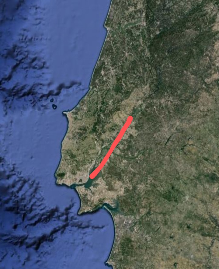
You can see former equatorial lines of emergence off the coast near Lisbon. One seafloor ridge points directly at Lisbon, and then continues on land as a broad valley just east of the city running south southwest to north northeast. It definitely appears that a section of land has been separated from the main Iberian Peninsula by this line and Lisbon is on this separated section. This is not to say that the obvious shift in the land which took place was accomplished entirely by the 1755 quake, but it was done by successive movement over time.
There are distinct broad valleys across southern Spain, and the one which hosts the city of Zaragoza in the northeast of the country. These are all the products of emergence lines, as we have seen in the geological theory. But these valleys formed very gradually by magma emergence and none would have the effect of separating a small stretch of land along the coast so that it no longer moved in concert, and so would not cause a quake like the one in 1755 that devastated Lisbon.
74) INSIGHTS INTO EARTHQUAKES
So much of the physical geography of the world today was formed by the tectonic plates composing the earth's crust. My belief is that these plates formed when the hot, early earth began to cool and the outer crust was the first to cool and contract, causing it to split into sections.
We know that the earthquakes and volcanic activity in the world is focused around the boundaries between these plates. These plate boundaries can often be clearly seen on a map as mountain ranges on land and as either ridges or trenches on the sea floor. Volcanic island chains, such as the Aleutians or Antilles, were formed when magma from the earth below came through the gaps between plates. The Mid-Atlantic Ridge, which runs the entire length of the Atlantic Ocean from north to south was formed by two plates moving away from each other, allowing magma to emerge from below.
Keep in mind that the tectonic plates do not usually conform to the coasts of the continents as seen on a map. The major exception to this is the west coast of North and South America. Also that segments of continent drifting around and colliding can take place independent of the underlying plates. For example, the Appalachian Mountains of the U.S. were formed by segments of continent colliding but is nowhere near a tectonic plate boundary.
Have you ever wondered why the world still has earthquakes? I mean, why do these plates keep jostling each other and causing earthquakes? Why have they not come to some kind of equilibrium and remained still? Simple logic tells us that earthquakes should at least be getting fewer and fewer as time goes on as the plates approach a state of equilibrium, just as with a bouncing ball each bounce is less than the one before it.
But earthquakes are actually getting worse and more frequent, if anything, and people familiar with the prophecies in the Bible of the last days of the world can tell you that this has been foretold. Just a few in recent years that I recall reading about are the devastating 2004 tsunami in southeast Asia caused by an underwater shift between the Pacific and Indo-Australian Plates, the Pakistan earthquake in 2005, Kobe in 1995, many in China up to the one in 2008, many in California, many more in Iran including the one centered on the ancient city of Bam, Armenia in 1988, Italy in 1980 and, Nicaragua in 1972.
I used to think that the centrifugal force of the spin of the earth was a factor in this continuous jostling of the tectonic plates that causes earth quakes, but now my thoughts are that it can only be a minor factor. And if it was some force from inside the earth that was keeping the plates from reaching an equilibrium so that earthquakes would cease, it would almost have to be equal in all directions and so would cancel out. I concluded that there must be some unseen dynamic driving the shifting of tectonic plates that was continuing to cause earthquakes and if we could understand this dynamic, maybe earthquakes could be predicted.
I am certain that I have found the dynamic that continues to cause earthquakes. It is the fact that the floor of the Atlantic Ocean is continually spreading outwards from the Mid-Atlantic Ridge. This ocean is widening by about 3-5 cm per year and the magma from the resulting gap that runs north-south along the floor of the ocean for it's entire length is where the magma emerges from below to form the Mid-Atlantic Ridge. The reason that this is still going on is that the earth has not yet reached a new equilibrium following the landings, and added mass, of the Continental Asteroids.
On the map, the Mid-Atlantic Ridge is the plate boundary that runs along the middle of the ocean. Iceland and Portugal's Azores Islands are where the ridge pokes above the surface.
This spreading of the Atlantic Ocean floor pushes the Eastern Hemisphere eastward and the Western Hemisphere westward. This has got to be the driving force behind the jostling of the plates that causes the world's earthquakes.
.
The line representing the spreading of the seafloor of the south Atlantic curves around Africa to the south and continues eastward across the Indian Ocean. The seafloor spreading pushed against the Indo-Australian Plate, causing the tsunami of 2004, as we can see on the map.
When the Atlantic floor spread further northward in the area between Brazil and north Africa, it pushed the African Plate against the smaller Arabian Plate, and into the Original Impact Line across Iran. This is what has caused the devastating quakes in Iran and neighboring Armenia. It is the spreading of the seafloor in the north Atlantic that leads to most of the quakes in east Asia as well as those in California and Mexico.
My belief is that there would be fewer earthquakes if the tectonic plates formed neat geometric shapes. The pushing against irregularly-shaped plates only makes it worse because the plate may have to shift more than once to regain equilibrium until the Atlantic seafloor exerts more pressure. The pressure builds up until a plate shifts but that pushes against neighboring plates.
This theory explains so much about how the continents got to be the way they are today. It even offers a neat and simple explanation of where the moon came from. And, just as the earth's poles and equator shifted after each landing of a Continental Asteroid to re-balance the earth's rotation, so magma must emerge from below to seek a re-balancing.
If we stop and think for a moment, it becomes clear that this addition of new material to the earth would have drastically upset the equilibrium it would have had at the time. There would be a lot of downward pressure due to the weight of the continents that would not have been there previously. A lot of magma would have been forced upward until a new equilibrium was reached.
The process of moving toward a new equilibrium after the impact of the Continental Asteroids still has not yet been reached. Magma is still emerging along the line across the earth, along which the seafloor is spreading. This is the driving force behind earthquakes and volcanic activity elsewhere. Geological processes move very slowly and it may be many more eons until a new equilibrium is reached and tectonic shifting ceases.
74b) EARTHQUAKES IN PERSPECTIVE (A SECTION OF "INSIGHTS INTO EARTHQUAKES)
There was a recent minor earthquake in the village of Olcott, on the U.S. shore of Lake Ontario, and I thought that we could use some perspective on earthquakes.
Earthquakes are driven by the effect of the earth's rotation that causes continental land masses to gradually move so that they collide with each other and with tectonic plate boundaries. The resulting earthquakes seem to us to be the exception, everything is going along fine until there is an earthquake. But that is only because of our short time perspective. Over the long term, earthquakes are very much the norm rather than the exception.
The reason for earthquakes is that tectonic movement is generally not continuous, but pressure builds up until a sudden slip takes place. It is fantastic earthquakes over millions of years that have built great mountain ranges like the Rockies, Andies, Himalayas and, Alps. Sometimes the earthquakes that happen today leave visible changes on the surface, but the changes from other quakes takes place deep underground.
What about the gradual slope in the city of Toronto, with the rise in elevation from the lake shore up to around Steeles Avenue? This is the result of the tectonic collision which formed the Appalachians, and Toronto residents can be sure that there were some tremendous earthquakes over millions of years that constructed this slope. The same can be said of the much more sudden change in elevation west of downtown as the east side of the Humber Valley, as seen on main east-west streets such as Bloor Street. Even after all of this time, the process is not quite complete and Toronto felt an earthquake in the late summer of 2011.
How many earthquakes do you think it took to create the complex system of ridges and mountains that are the Appalachians? Almost certainly in the millions. On a geological time scale, earthquakes are a steady process and are anything but the exception.
Like the countless raindrops that it takes to fill a pond, countless earthquakes over the eons crafted the landscape that we have today. As a sculptor chipping away at a block of limestone, each "chip" in the construction of our mountains and ridges is represented by an earthquake.
75) NORTHERN AND EASTERN CANADA
There are a number of very definite yet difficult-to-explain lines of mountains in northern and eastern Canada. This includes the mountain ranges of Labrador, Newfoundland and, Baffin Island. There is also a large mass of mountains in Quebec. These ranges of mountains are not of volcanic origin, and cannot be explained by tectonic collision because the continent of North America is moving westward, not eastward, by spreading of the seafloor along the Mid-Atlantic Ridge. Newfoundland was later shaped by the Appalachian collision, as we saw in "All About The Appalachians" on this blog. Neither can the rocky masses of the Queen Elizabeth Islands, in the far north of Canada, be explained by conventional geology. The origin of the vast and rocky island of Greenland is another such mystery.
There is a vast gap between what I have written as the western end of the Original Impact Line, in Europe, and the impact site of the Third Continental Asteroid, from where it originated, in Antarctica. It is true that the Original Impact Line has shifted over the eons by tectonic movement, driven by the spin of the earth, but shouldn't we expect that there might be some missing pieces of the Original Impact Line left over? The patterns of mountain ranges in Alaska show evidence of a land mass being split apart by magma emergence lines beneath it, as we see in certain other pieces of land, such as Spain, that is believed to be from one of the Continental Asteroids and positioned over a magma emergence line.
We know that the Canadian Shield, the dense layer of underlying rock across the eastern half of Canada, was originally of volcanic origin. My geological theory of the Continental Asteroids and lines of magma emergence has it as magma that emerged from below at a pole, where longitudinal lines of emergence converge. The north pole transitioned across this area as it made it's way from the second pole position, at the Great Basin in the western U.S. to the present position of the north pole in the Arctic. My theory is that various pieces of the Third Continental Asteroid became lodged against the magma emergence which ultimately formed the Canadian Shield, and this explained eastern and northern Canada as we see it today.
This is not the same thing as the shattered pieces of the Original Impact Line in Europe, which I believe were created by a separate comet impact. Remnants of longitudinal lines of emergence from the north pole's transition to it's present position in the Arctic can still be seen today as James Bay, Georgian Bay, the Ottawa-Bonnechere and Sanguenay Grabens, the Parry Channel in the Arctic, the Foxe Basin and, between Greenland and Canada.
The reason that the Original Impact Line extends across the world as it does is that the Third Continental Asteroid, which we have seen impacted the earth at a relatively low angle, would have been in orbit around the earth before the impact, which would have taken place during the final decaying orbit. When collision with the earth took place, the Third Continental Asteroid would still be moving around the earth. The result is what we see today as the Original Impact Line, as a trail of rocky land mass across the world.
The loss of mass during the final orbit would have transmitted the remaining orbital energy to the mass that had not yet contacted the surface of the earth. This added orbital energy, in proportion to the mass, would have lifted that mass back into space, where any remaining pieces would have eventually come back together by gravity to form the moon. This is what many scientists believe took place, the astronomical body which collided with the earth is commonly named Theia.
But my theory is that it formed the continents, as well as the moon, and that there was actually three Continental Asteroids. As a general rule, I believe that all tectonic collisions between land masses on earth are between a piece from different Continental Asteroids.
I consider it likely that these lines of mountains in the North American Arctic and eastern Canada are the fragments of the Third Continental Asteroid from between Antarctica, the site of impact for the Third Continental Asteroid, and the western end of the Original Impact Line that I have described in Europe.
76) THE AMAZON VECTOR
The Amazon River is the very pronounced line extending across the dark green rain forest of northern Brazil. The Amazon is by far the greatest river in the world, and you can see tributaries flowing into it from both north and south. The Amazon River flows eastward and meets the Atlantic Ocean at the city of Macapa.
The Amazon River is just about exactly on the equator. You can see where the equator is in the satellite imagery as the undersea ridge line running from the Galapagos Islands, in the Pacific Ocean, to the west coast of South America at the nation of Ecuador. Remember that, in my geological theory concerning lines of magma emergence, we should expect such emergence along the equator, and in equatorial regions of land, due to the centrifugal force of the earth's rotation. In fact, it is this equatorial magma emergence below the land of South America that created the vast Amazon Basin, which is drained by the river.

The east-west ridge on the seafloor off the coast of Ecuador is caused by magma emergence along the earth's present equator, brought about by the spin of the earth. At the eastern end of the undersea ridge is the Galapagos Islands.
Next, look at another straight-line ridge on the Pacific seafloor. This is known as the Nazca Ridge, because it meets the coast of Peru at the city of that name. Remember that, in my geological theory of Continental Asteroids and lines of magma emergence, I identified this ridge as the remains of what we could call the third equator. The poles and equator shifted after the earth's rotational balance was upset by each of the three Continental Asteroids that landed on earth, and the mass of which forms the continents (as well as the moon) of today. The poles and equator that we have today is the third such set.
Magma emergence from below along these lines of emergence changes very slowly. Even after the poles and equator shifts in an effort to re-balance the planet's rotation after the added mass of a Continental Asteroid by locating one of the poles in the center of the new mass, magma emergence continues along those lines for a long time. That is why the flat land of the Amazon Basin is so broad, it is where the present and the previous equators cross.
Now, take a close look at the course of the Amazon River itself. Since this region, which is drained by the Amazon, is the product of equatorial magma emergence, due to the rotation of the earth, and since the vast volume of water in the river must be affected by the momentum of the earth's eastward rotation, the most logical route for the river would be a direct eastward flow along an east-west line right along the equator.
While the river does flow eastward, that is not quite what we see. The river actually flows west south west to east north east. But there is a simple explanation for this that underlines how my geological theory of how these lines of magma emergence operate.
If you look at the undersea ridge, running eastward off the coast of Ecuador, which represents the present equator, and then the undersea Nazca Ridge, running to the southwest off the coast of Peru, which represents the previous equator before the shift caused by the landing of the last (third) Continental Asteroid, we can see that the course of the Amazon River represents a vector between these two lines, with the present equator having somewhat more influence on the course of the river than the previous equator, which is what we would expect.
I consider this as simple, yet convincing proof of the validity of this theory.
77) THE IMPACT THEORY OF EAST ASIA
Compare the comet impact in the Tyrrhenian Sea with that in the Sea of Japan. Both produced the emergence of magma which created a largely volcanic country. Both pulled a section of a nearby continent closer to it to create still another country. The comet impact in the Tyrrhenian Sea not only shattered the original Impact Line from that point westward, it tore Greece loose from Turkey with fragments remaining in between as the Aegean Islands. In the same way, the comet impact in the Sea of Japan tore Korea loose from the Asian mainland. Korea, like Greece and Turkey, is composed of rocky and mountainous terrain that is not volcanic in origin and is difficult to explain.
If there was indeed a comet impact in the Sea of Japan, it would have forced magma to emerge from below and indeed it did, forming Japan. It is true that magma emerges from between tectonic plates, which is why Japan is prone to earthquakes because it is on a plate boundary. But why should such a massive amount of magma emerge in this particular place, to form a large country such as Japan? It is explained by the comet impact. But what about the other side of the impact in the Sea of Japan? Shouldn't the magma have broken through there?
Indeed we find that Mount Baeku, considered as sacred by North Koreans and on the border between that country and China, is where the magma broke through on the Asian mainland. Why else would there be a volcano in such a place, which produced one of the greatest volcanic eruptions in history? It is in very mountainous terrain, but this is the only mountain there that is volcanic. How can we explain this, other than a comet impact, which are known to have brought water to earth? Considering that the area of this comet impact bears so much similarity to the one on the other side of the world, in the Tyrrhenian Sea.
If magma emerges from below, along lines of emergence, then why does it sometimes emerge from one point as a volcano? it makes sense that upwelling magma will break through as a volcano, instead of emerging along a line due to the earth's rotation. if something is hindering it from emerging and it has to break through.
The barrier that must be broken through can be either previous magma that emerged and hardened, or coverage by material from Continental Asteroids. But there must be something that must be broken through.
Japan and Italy are both composed of volcanic magma. But in Japan, volcanoes are scattered, while in Italy they occur only in the southern part of the country. Both resulted from magma being forced upward by a comet impact, which left no debris but added water to the oceans. But the magma that composed Japan emerged through the gap in the plate boundary, while that which composed Italy didn't. Italy doesn't have volcanoes in the northern part of the country because magma emergence, caused by the comet impact, was not continuous. There was no more magma to break through the first magma, in the northern part of the country, other than the round lakes to the north of Rome.
But what about the three famous, periodically active volcanoes in the southern part of Italy-Vesuvius, Etna and, Stromboli, which is actually in the sea? What did they have to break through so that magma came through at one point, instead of continuously throughout the country?
Remember the Original Impact Line. If the comet landed on it, as my theory supposes, the magma thus forced upward would have to break through the Original Impact Line. Turkey represents the Original Impact Line, continuing eastward. Notice that, if we continue the line of the north coast of Turkey westward, all three of the Italian volcanoes are south of that line.
Could that be because these volcanoes began when the magma that was forced upward by the impact of the comet in the Tyrrhenian Sea had to break through the Original Impact Line above, which was also broken by the impact of the comet? This explains why there are no volcanoes in northern Italy.
The Mid-Atlantic Ridge is a very special phenomenon in the world. It is an undersea ridge that stretches the entire length of the Atlantic Ocean from north to south. In fact, the Mid-Atlantic Ridge is what actually creates the Atlantic Ocean. Magma from below emerges along it’s length, causing the western and eastern hemispheres to be driven further apart by the resulting spreading of the seafloor. It is this outward pressure along the Mid-Atlantic Ridge that forms the long range of mountains, the Rockies and Andes, as the land mass of the western hemisphere collided tectonically with the Pacific Plate.
There are lines of magma emergence across the world, but why does one as prominent as the Mid-Atlantic Ridge form where it does? This really requires some special explanation. We know that the spin of the earth causes magma to emerge along the equator, and that the laws of fluid dynamics then cause magma to emerge along longitudinal lines, in a perpendicular direction from pole to pole, in order to balance this equatorial emergence. But that still does not come close to explaining why such a prominent feature of the earth’s physical geography as the Mid-Atlantic Ridge formed where it did.
The Mid-Atlantic Ridge is a part of what I refer to as the W-line, for it’s shape, which goes around the world and is the main line across the globe along which magma emerges from below. The W-line is composed of the Mid-Atlantic Ridge, which then curves eastward around the south of Africa, and passes between Australia and Antarctica. The W-line then proceeds from there to the west coast of North America, where it forms the Sea of Cortez (or Gulf of California) and the broad valley system that runs south to north in California to the Columbia Basin in Washington State. The middle branch of the line that gives it it’s W-shape extends northward from the line, as it passes through the Indian Ocean, and turns westward to form the Red Sea between Africa and the Arabian Peninsula. But why should there be such a relatively sharp turn to form such a mostly north-south line through the Atlantic Ocean?
There is the “bulge” in the Mid-Atlantic Ridge, the southernmost point of which is just north of the Equator. This bulge fits around the northwest part of Africa, and is what separated it from the east coast of the U.S. where the two once collided to form the Appalachian chain of mountains. The mountains are the collision front of the two. The Mid-Atlantic Ridge was some distance to the east, under Africa. The land between the Appalachians and the sea is land that was once a part of Africa. The reason for this bulge is that the Mid-Atlantic Ridge went around what is known as the West African Craton.
But why is the Mid-Atlantic Ridge there? This really requires some special explanation. I have never seen an explanation of why the Mid-Atlantic Ridge is where it is.
There is one simple explanation of why the Mid-Atlantic Ridge is where it is, and why it has the form that it does. This geological theory tells us about what I have named “The Original Impact Line”.
The third of three Continental Asteroids had it’s main impact site at Antarctica, which is why Antarctica has by far the highest average elevation of any continent, even though it is a relatively small continent. But the impact was at an angle, and a line of rocky debris formed across the world that has long since been tectonically detached from Antarctica. This Original Impact Line is the otherwise unexplainable line of mountains and very high terrain that extends across the eastern hemisphere from Greece and Turkey through Iran to central Asia, which includes the Tibetan Plateau and the Himalayas.
The Original Impact Line forms the “backbone” of Asia and contains so much mass that it must have an unbalancing effect on the earth’s rotation. In the theory, the reason that the earth must have undergone three major shifts on it’s axis was to regain rotational balance following the impacts, and added mass, of the three Continental Asteroids. But the tectonic detachment of the Original Impact Line also affected the rotational balance of the earth. Magma emerges along lines on earth due to it’s rotation, and part of the reason for this emergence is the added mass of the continents, which are the rocky debris from the Continental Asteroids.
My conclusion is that the Mid-Atlantic Ridge is positioned perfectly to act as a perpendicular balance to the mass of the Original Impact Line. The magma that piles up along the Mid-Atlantic Ridge to form the long undersea mountain chain. This mountain chain then acts as a perpendicular balance to the Original Impact Line. Remember that in the section 49)“The Impact Theory Of Europe” we saw how the western section of the Original Impact Line was broken up by a comet (or asteroid) impact. The bulk of the broken off section drifted northward tectonically to become what is know the mountains of Scandinavia, the Kjolen Mountains. The eastern and western hemispheres have also moved apart since the Mid-Atlantic Ridge formed, but the Original Impact Line once reached to near where the Mid-Atlantic Ridge is located, and magma emerged along it because it was perpendicular to the Original Impact Line and so acted as a balance to it.
79) THE MYSTERY OF MOUNT VESUVIUS
One of the best-known volcanoes in the world is Mount Vesuvius, adjacent to Naples. But why is Vesuvius located where it is? Southern Italy and Sicily have several active volcanoes, but why are they located exactly where they are if most of the entire country is of volcanic origin?
The magma emergence line that forms Mount Vesuvius also forms the Bay of Naples.

The line continues directly across the Italian Peninsula and the Gargano Peninsula, which is a piece of the broken Original Impact Line, rests against the emergence line on the Adriatic coast.
Another question involves the Gargano Peninsula extending from the east coast of southern Italy into the Adriatic Sea. Why should this peninsula be there? The peninsula is composed of rocky high ground, meaning that at least most of it did not originate from seafloor being forced upward like the southeastern peninsula of Italy, adjacent to the Gulf of Taranto.
My Lines of Emergence hypothesis has a neat explanation for the location of Mount Vesuvius, and the physical geography of southern Italy. The theory revolves around magma from below that emerges in lines across the earth, driven by the earth’s rotation, and accounting for so much of both the surface topography of the earth as well as the seafloor.
The spin of the earth causes magma to emerge from the equatorial region and then, under the principles of fluid dynamics, this equatorial emergence must be balanced by perpendicular emergence along periodic longitudinal lines of emergence. The rocky material that composes the continents on earth arrived from two Continental Asteroids. As the first one landed, the added mass unbalanced the earth’s rotation and caused a shift of the earth’s axis in order to re-balance the rotation. As this happened, the equatorial and longitudinal lines of emergence also shifted, but magma would have continued emerging for a long time after the shift. If magma has a reason to be concentrated enough in one place it can emerge from a point, rather than along the usual lines, and is then known as a volcano.
The Bay of Naples, on the west coast of southern Italy, is an ideal natural harbor, which appears very much as being of magma emergence origin from the rounded bay which often forms where an emergence line on land meets the sea. This emergence line, across southern Italy, forms a straight line with the south shore of the Gargano Peninsula extending into the Adriatic Sea on the opposite side of Italian Peninsula. Notice that Mount Vesuvius lies right on this line.
The physical geography of this region is ideally explained by this pre-existing emergence line, but then the comet impact and volcanic emergence, described in the section 49) "The Impact Theory Of Europe" that formed the Italian Peninsula and the islands of Sicily and Sardinia. We have seen similar explanations of other famous mountains, which are now also supporting documents within this theory involving the origin by emergence lines of Mounts Kilimanjaro, Ararat and, Royal, and also Table Mountain at Cape Town.
Why is there this straight line of emergence across the southern Italian Peninsula at an angle of approximately 45 degrees to the present equator and lines of longitude? Notice that the line of emergence across southern Italy is almost parallel to Lake Balaton in Hungary, which we saw as a “line of strongest emergence” in the emergence center of southeastern Europe, as described in 40)“Centers Of Emergence Across The World”. If a former equator is at an angle of 45 degrees to the present equator and longitudinal lines, it means that it formed as an equator when the earth’s poles were 45 degrees from their present location.
We saw that the line of emergence from the Po Valley, the lowland across northern Italy, through the Balearic Islands off the east coast of Spain, is a former equator from the third polar era when the south pole was what is now the undersea ridge structure around the island of Madagascar, known as the Mascarene Ridge. The former equator would have shifted as the south pole itself shifted across the Indian Ocean toward Australia, as the earth moved from second to the present fourth polar position.
Why else would Italy tectonically collide with Europe to form the Alps, but yet there is the broad Po Valley between the two? It could only be that the Po Valley is a line of emergence, a former equator, which continued to broaden after the collision of Italy with Europe took place.
To the south of the Bay of Naples, on the west coast of southern Italy, is another bay that also looks just like the product of an emergence line across the Italian Peninsula, at Salerno. But this is what we should expect if the former equator was shifting as the poles shifted due to the impact of the Third Continental Asteroid. It would have first formed the Bay of Naples with the emergence line across southern Italy, and then the bay at Salerno as the former equator shifted position as the poles shifted.
If the islands of Sicily and Sardinia are the product of the same comet impact that produced mainland Italy, then why is there such a gap between the two islands? Why is there not a more continuous loop of land? We know that the magma emergence which formed Italy pressed up against emergence lines in the area, and this affected the final shape of the land which formed.
The magma forming the Italian Peninsula itself pressed against the line of the Adriatic Sea, which was a former longitudinal line of emergence from the era of the second south pole. The emerging magma of the southwestern coast of Sicily pressed against the emergence line of the valley across northeastern Spain which hosts the city of Zaragoza.
Notice also how the southwestern corner of Sardinia terminates on the continuation of the line of the southwestern coast of Sicily, which is along the line of emergence which can be seen to continue as the broad valley across northeastern Spain which hosts the city of Zaragoza. The islands of Sardinia and Corsica lie against a prominent north-south line of emergence from the present polar era, that extends northward to form the Rhine Valley.

One thing that I have not pointed out previously is that this north-south longitudinal line of emergence, against which rests the islands of Sardinia and Corsica and which extends northward into Europe to form the Rhine Valley, also creates the harbor on the coast of northern Italy around which the city of Genoa is built. This can be seen in the satellite imagery of the map link. Genoa is the city that is known for the alleys of it's medieval street pattern and for being the birthplace of Christopher Columbus. This makes Genoa similar in form to Mumbai (Bombay) in India, as we saw in the supporting document 71) "The Geological Geometry Of India", because Mumbai is also built around a natural harbor which formed where a prominent north-south longitudinal line of emergence intersected a coastline.

With this in mind, how existing lines of emergence affect the sudden emergence of more magma from such an event as a comet or asteroid impact. Notice how a line from the peninsula on the Adriatic coast of Italy through the Bay of Naples leads right to the southernmost extent of Sardinia and, similarly, a line from that peninsula through the bay at Salerno leads right to the westernmost extent of Sicily. Notice that the continuation of the line of the line of emergence across southern Italy through the bay at Salerno first defines the westernmost extent of Sicily, then continues to form the Gulf of Tunis on the shore of north Africa, which looks very much like a bay formed by a line of emergence meeting a coastline. This line of emergence was, once again, a former equator from when the poles were shifting from the third to the present fourth position to re-balance the earth's rotation after the added mass of the Third Continental Asteroid.
Further southeast in Italy, we see that there is another line of emergence that is virtually parallel to the one through Naples, Mount Vesuvius and, the Gargano Peninsula. This line forms the nearly straight line southwest to northeast coast of the Gulf of Taranto. The line continues inland at the city of Taranto as the body of water known as Mare Piccolo.
More of Italy's geometry. The line of the northern part of the east coast of Sicily continues as the coast of the Gulf of Taranto.

In the opposite direction, on the other side of the southwestern Italian peninsula of Calabria, we see that the line forms the island of Stromboli, which is an active volcano. As with the other line across southern Italy, there is no sign that it continues in Montenegro on the other side of the Adriatic Sea. If we follow the virtually straight line of the northwestern shore of the Gulf of Taranto along this emergence line, and continue the line to the southwest, we see that the same line defines not only the northwestern shore of the southernmost peninsula of mainland Italy, in Calabria, but also the northeastern shore of the island of Sicily, south past the city of Catania.
Then we see that, just as Mount Vesuvius is situated on the emergence line through the Bay of Naples and past the south shore of the Gargano Peninsula, so another world famous volcano in Mount Etna is located on this line of emergence in Sicily.
Now, if we could say that this same line of emergence which forms the straight line from the northwest shore of the Gulf of Taranto to the northeastern shore of Sicily split in two because Sicily formed right on it, then that would ideally explain Italy's third active volcano, which is Stromboli and the chain of several volcanic islands to the north of Sicily. These islands and Stromboli formed as magma from the comet (or asteroid) impact in the Tyrrhenian Sea, which formed Italy, Sicily and, Sardinia, pushed against this line of emergence.
It should not be surprising that a line of magma emergence can produce a straight-line coast which is forming from other magma emergence, from outside the line, remember that the straight-line southwestern coast of Sicily also formed as such because it is against a line of emergence.
The explanation for this line, virtually parallel to the first line of emergence, is that the former equator that it represents was shifting as the poles were shifting in an effort to re-balance the earth's rotation after the added mass of the Third Continental Asteroid.
As a parallel to the lines of magma emergence across southern Italy, we can see that there is a small emergence line that forms a broad valley across Sardinia, from Cagliari in the southeast to the bay on the west coast of the island adjacent to Oristano, which is also the result of magma emergence of the comet impact in the same way as Italy, from one coastal emergence bay to another. This must have been a pre-existing line of emergence which continued as the much larger volume of magma, which formed the entire island after the comet impact, and spread the new magma apart to form this valley.
One thing that must be pointed out about the lines of magma emergence across southern Italy is that there is no sign at all that the lines continues into the Balkan Mountains, on the other side of the Adriatic Sea. Why would the line cross the mountainous Italian Peninsula, but there be no visible trace of it in the mountains that are not too far away on the opposite side of the sea?
The answer is that this gives us a timescale of when the impact which produced the Italian Peninsula took place. The line of emergence across southern Italy was already an active emergence line when the tremendous impact of the asteroid or, more likely, comet took place. We have seen in section 49) "The Impact Theory Of Europe", that the impact was right on the Original Impact Line and it tore a section of that line away, Greece and the Balkan Mountains. The line of magma emergence across southern Italy must have led to the center of magma emergence that I pointed out in southeastern Europe, it points right at it. But the dislocation of the Balkan Mountains by the impact blocked the line, and not a trace of it can be seen in those mountains. The rest of the Original Impact Line continues through Turkey and Iran to central Asia.
With that in mind, we can see another timescale of when the impact which formed Italy took place in the Alps. The Alps Mountains interrupt the longitudinal line of emergence along which Sardinia and Corsica lie, and which continues far to the north as the Rhine Valley. Since this line is north-south, we know that it must be a longitudinal line of emergence from the present polar era, meaning that the impact most likely took place after the last polar shift. The Alps are actually another piece of rocky high ground that was broken off the Original Impact Line by the impact, and was altered further by the later tectonic impact of the Italian Peninsula. We can see evidence of this impact in how it has pushed the Rhone Valley of southeastern France westward it was once a part of the Rhine Valley, and formed a straight line with it.
Notice again the Gargano Peninsula extending from the east coast of Italy into the Adriatic Sea. If we continue the course of the line of emergence across southern Italy, we see that the southern edge of the peninsula is a straight line, right along the line of the emergence line across southern Italy, but the northern shore of the peninsula isn’t anything like a straight line.
This is because the Gargano Peninsula is actually another piece of the Original Impact Line that I have not previously identified. The other identified pieces are all in western Europe, and are described i section 49) "The Impact Theory Of Europe", and include the island of Corsica and the Massif Central of southeastern France. Remember that the main difference between Sardinia and Corsica is that Sardinia is of volcanic origin while Corsica is a piece of the Original Impact Line.
The piece that forms the Gargano Peninsula may have broken off what is now Greece and the coastal mountains of the Adriatic Sea, into the former Yugoslavia which was displaced, according to this theory, from the rest of the Original Impact Line which continues through Turkey and across Asia. The piece of this shattered section of the line drifted tectonically and then came to rest against the magma that had emerged to form Italy and the line of magma emergence across southern Italy, let's call it the Vesuvius Line, to form the Gargano Peninsula of today.
The reason that the south shore of the Gargano Peninsula forms such a straight line can be seen by looking closely at the satellite imagery. There is an extensive flat area, around and to the west of the city of Manfredonia, that is right next to the rocky high ground of the broken piece of the Original Impact Line that is the Gargano Peninsula. This flat area, so close to rocky high ground, can only be seafloor that was forced upward by movement of the higher ground. This is just what we would expect if my hypothesis is correct that this peninsula is a piece of the Original Impact Line resting against both mainland Italy and the line of emergence across southern Italy that forms Mount Vesuvius and the Bay of Naples.
80) MER PICCOLO IN SOUTHERN ITALY
I had wondered what would happen when seafloor is forced upward by tectonic movement, creating a flat limestone landscape, but there might be an active line of magma emergence beneath that landscape? I found an answer in the southeastern peninsula of Italy.
Remember that, in the lines of magma emergence theory, the spin of the earth causes magma to emerge along the equator. Then, according to the rules of fluid dynamics, this equatorial magma emergence must be balanced by perpendicular longitudinal lines of emergence. Next, three successive Continental Asteroids land on earth, the mass of which forms the continents of today.
When each Continental Asteroid lands, the additional mass unbalances the earth’s rotation and this causes the earth to shift on it’s axis in an effort to regain rotational balance by moving one of the poles to the center of the new mass. The earth has thus undergone three major shifts on it’s rotational axis, so that we could say we are now in the fourth polar era. This is why the south pole is in Antarctica, which was the bulk of the mass of the Third Continental Asteroid.
The essence of this theory is that if the earth has undergone three major shifts on it’s axis, due to the added mass of the Continental Asteroids which unbalanced the rotation, and each era between the shifts had it’s own pattern of equatorial and longitudinal lines of magma emergence, and activity continued in these lines for a long time after the next shift takes place, this explains in greater detail then ever before both the large-scale landscape of the earth and the ridges on the seafloor.
As we saw in the above section 79) “The Mystery Of Mount Vesuvius (And Etna And The Gargano Peninisula)”, there are two lines of magma emergence to be seen across southern Italy. Both are leftover lines of the former equator that also forms the Po Valley across northern Italy, as it shifted to the south along with the poles in an effort to re-balance the earth’s rotation after the landing and added mass of the Third Continental Asteroid. All of these lines across Italy point at the center of emergence lines in southeastern Europe that we saw in section 40) “The Centers Of Magma Emergence Across The World”. The northernmost of these lines of emergence across southern Italy explains Mount Vesuvius and the Bay of Naples, as well as the straight line southern shore of the Gargano Peninsula, which are all directly on the line.
It is the southernmost line of emergence across southern Italy that we are concerned with here. This line can easily be seen on a map as forming the nearly straight line northwestern coast of the Gulf of Taranto, the northwestern coast of the southwestern Italian peninsula of Calabria, and the northeastern coast of the island of Sicily, as far south of the city of Catania. Also on this line, where the straight line northwestern coast of the Gulf of Taranto meets the southeastern peninsula of Italy, in the province of Apulia (Puglia), is the inlet at the city of Taranto known as the Mer Piccolo, or Little Sea. It has to be called a sea, and not a lake, because it is salt water.
Notice that both the Strait of Messina, between mainland Italy and Sicily, and the Sicilian volcano of Mount Etna are on this line and are explained by this line. Magma emergence usually occurs along lines, due to the rotation of the earth, but if it becomes concentrated enough by an intersection of lines or some outside factor, it can emerge from one point, which is known as a volcano. Why would there be a strait, like the Strait of Messina, separating two masses of magma that had emerged from the same source, unless there was another line of emergence beneath them and pulling the mass of magma that came later apart?
Notice also the islands of Malta, to the south in the Mediterranean. On the main island, there are several inlets aligned northeast to southwest that are parallel to one another. Malta is right on the line of this emergence line across southern Italy and the inlets are directly aligned along this line. Also, Malta is positioned right at that would be the intersection of this line of emergence across southern Italy and the former longitudinal line of emergence that extends to the northwest, across northeastern Spain and hosts the city of Zaragoza, and then points directly at the circular undersea ridge structure immediately west of Australia, which was once the south pole as it shifted toward it's present position in Antarctica. My conclusion is that Malta is pieces of the Original Impact Line that got positioned against this intersection of two emergence lines and had it's landscape pulled apart, forming these parallel inlets, by the line of emergence across southern Italy.
Just as Mount Vesuvius, the Bay of Naples and, the straight line southern coast of the Gargano Peninsula are on the northernmost line of emergence across southern Italy, Mount Etna, the Strait of Messina and, the straight line northwestern coast of the Gulf of Taranto, and the Mer Piccolo, are on the southernmost line of emergence across southern Italy.
The structure of this southeastern peninsula of Italy is similar to that of Florida in nature. It is easy to see, on Google Street View, how flat the landscape is, in comparison to most of the rest of Italy. It is former seafloor forced upward by momentum as a tectonically moving land mass is halted by a sudden collision at the opposite end.
This southeastern Italian peninsula in Apulia (Puglia) formed when the tectonic movement of Italy was halted by the collision with Europe, which formed the Alps. Florida formed when the tectonic movement of what was then northwest Africa was halted by the sliding collision with what is now North America, which formed the Appalachian Mountains. The bodies of endless millions of microscopic creatures collect on the bottom of a warm shallow sea, and are gradually compressed by the weight of the bodies above into limestone. When the seafloor is forced upward by some tectonic movement, it will form a flat limestone rock strata landscape.
Limestone can gradually dissolve in water. This can result in the formation of caves, where there are limestone cliffs that have been forced upward, or sinkholes where the rock strata landscape is flat. In caves, the dissolved limestone can re-crystallize to form stalactites and stalagmites. This property of limestone to dissolve and re-crystallize is used in cement, which is a mixture of limestone and clay. A sinkhole forms when flowing water carves a channel underground in layers of limestone, and then the roof collapses to form a hole.
The small lakes all over Florida are actually sinkholes which have formed over millions of years. The reason that there are not similar sinkholes in Apulia (Puglia) is simply that it is dry because, even though it is surrounded by water, the prevailing wind is from the east and it passes over land and so does not bring much rain. Sinkholes would be able to form in Apulia (Puglia), the same as in Florida, if only there was enough water to dissolve limestone.
Water does not seep in from the sea to dissolve and form sinkholes in a limestone landscape. It has to be flowing water that comes from rainwater passing through the drainage basin. But if there happens to be a line of magma emergence beneath the limestone landscape, it can change this. The spreading of the land along the line of magma emergence affects the limestone, making it more porous to water so that water can gradually seep in from the sea. The only example of this in the world that I can see is Mer Piccolo (the Piccolo Sea), on the southeastern Italian peninsula of Apulia (Puglia). Mer Piccolo is also referred to as Taranto Harbor, because of the adjacent city of Taranto.
Mer Piccolo is actually a series of three sinkholes. The line of magma emergence broadened the land and weakened the structure of the underlying limestone, making it somewhat more porous to water, so that water was able to seep in from the sea which does not usually happen in a landscape composed of limestone strata. Unless the water that forms it is flowing, a sinkhole will eventually end up as somewhat circular. This can easily be seen in the landscape of Florida, with some sinkhole lakes that are highly elongated along flowing water and others that are nearly circular.
Lakes formed by sinkholes are relatively shallow. Sinkholes do not form really deep lakes like the three circular lakes in west central Italy, from Rome north to Perugia. My impression of those lakes is that they are the result of “bubbles” of water that formed by rapid magma emergence during the formation of most of Italy as an asteroid (or more likely, a comet) collided with the earth and forced the magma upward.
Mer Piccolo is shallow, as we would expect a sinkhole lake to be. Without even looking up the depth, we can see that it must be shallow in the satellite imagery because the bridge across it is built on abutments that are set in the water.
Mer Piccolo is quite similar in nature to Tampa Bay, in Florida, which is also actually a large multiple sinkhole lake on a coast so that it serves as a harbor. The difference between the two is that Tampa Bay was formed by erosion of limestone rock strata by water flowing toward the sea, and Mer Piccolo, in dry southeastern Italy but on a magma line of emergence, was formed by water flowing in from the sea. We can see that Tampa Bay is similarly shallow because there are bridges across it with their abutments set in the water. Another roughly circular shallow sinkhole lake is Lake Pontchartrain in Louisiana.
In Mer Piccolo, the first sinkhole formed alongside the Gulf of Taranto, on the line of emergence across southern Italy. The line further north, I referred to as the Vesuvius Line after the volcano on it, so let’s refer to this as the Etna Line, after the famous volcano on it. This formation of the sinkhole left the island off the coast, and the circular form of this first sinkhole can be easily seen in the satellite imagery.
When this sinkhole had fully formed, water seeped into the limestone from it and the process repeated itself. The end result is the series of three consecutive sinkholes that are referred to today as Mer Piccolo. I cannot see anything else like this in the world. There is a peninsula remaining between each of the sinkholes, just as there is between the two sinkholes that form Tampa Bay. The city of Taranto is located on the outermost of these two peninsulas.
Notice that the series of three sinkholes do not form a straight line, as we know the line of magma emergence that caused them to form did. The line of three sinkholes actually curves toward the south as we move inland from the Gulf of Taranto.
But remember that the line of magma emergence was a former equator from the time between the second and present third polar eras. The former equator was itself changing position as the earth shifted position on it's axis in an effort to rebalance it’s rotation after the added mass of the Third Continental Asteroid. The movement of the line of emergence was taking place at the same time as the series of three sinkholes was forming. Since it was the presence of the line of emergence that weakened the limestone structure of the peninsula by pulling it apart as magma spread apart beneath it, thus making the limestone rock strata more porous to water so that the sinkholes formed, we should expect that the series of sinkholes would shift from being a straight line as the line of emergence shifted southward.
I cannot see anything like this pairing of a line of magma emergence and sinkholes in a limestone-based landscape anywhere else in the world.
81) THE REAL STORY OF THE LEANING TOWER OF PISA
The established story about the Leaning Tower of Pisa is that it began to lean almost as soon as construction began, due to issues with the underlying soil. As construction proceeded, the tower leaned even more, but finally it was completed. While building a high tower, on an important project right next to the city's cathedral, to continue building as the tower leaned more and more would be absolutely absurd. The problem could have easily been solved by just starting over with a wider base for the tower, or just moving a short distance away. I am certain that the tower only began to noticeably lean after it was completed.
The tower is not wide in diameter, so how could the soil and underlying rock be just fine on one side but not on the other side that was so close by? Why don't we see any other such towers or obelisks that lean like this?
But then the next question becomes: Why does the tower lean, and why does it lean in the direction that it does?
Another question, that turns out to be related, is why Venice is sinking. Venice is the city, on Italy's Adriatic Sea coast about 235 km (150 miles) northeast of Pisa, that famously has canals for many of it's streets, and is still gradually sinking into the sea.
My geological theory about how the earth's surface is shaped by lines of magma emergence has a simple answer to both of these questions.
When the south pole was at what is now the undersea Mascarene Ridge, just east of Madagascar, the equator was across what is now the broad Po Valley across northern Italy. The former equator, along which magma would emerge from below as driven by the spin of the earth, can be seen to continue to the west as the sea between Spain's Balearic Islands and the mainland.
At the same time, what is now the Adriatic Sea was a longitudinal line of magma emergence which, according to the laws of fluid dynamics, exist to balance the perpendicular magma emergence from the equator. As magma emerges from below, it tends to form ridges on the seafloor but broad valleys on land as the land is spread apart by the magma.
You can easily see, on a map of the world, how the elongated shape of the Adriatic Sea, if continued to the southeast, points directly to this undersea ridge structure around Madagascar, showing that it was a former line of emergence. The Po Valley can also be seen to be positioned to be a former equator if the south pole was at that point.
The Gulf of Venice is a main intersection between two of the prominent lines of magma emergence from that era. We should expect that the land would be especially spread apart here, as this is what formed both the Adriatic Sea and the Po Valley.. Venice is right at the intersection of the two and, as the land spreads apart, this explains why Venice is gradually sinking.
The era when the south pole was at the Mascarene Ridge is long past, but geological processes change very slowly and this process is still actually mildly active.
Suppose that you have a piece of carpet, not a rug but a rigid piece of carpet. Now suppose that you put a tall and narrow jar on the carpet, shaped like the Leaning Tower of Pisa. Next, push the carpet forward but slow the rate at which you are pushing it, first faster and then slower. The jar would tend to tip in the direction in which the piece of carpet is being pushed. The top of the jar still has the momentum from when the carpet was moving a little bit faster and, as the carpet slows, it would tend to tip in the forward direction.
This is what is happening to the Leaning Tower of Pisa. The spreading apart of the Po Valley, the former equator, is pushing the Appenine Mountain range, and Pisa just on the other side of it. The rate of the expansion is gradually slowing, as the former polar era fades further into the past, but the top of the tower, just like the jar on the carpet, has more momentum than the bottom of the tower.
Just as when something is large enough, like a large land mass or a sheet of glacial ice, it is affected by differences in the rotational momentum of the earth from one place to another. This rotational momentum is greater toward the equator and lesser toward the poles. This is why glaciers tend to move toward the equator. If something is large enough, the side toward the equator will be pulled more strongly by the earth's eastward rotation than the other side, and this is what causes hurricanes to spin.
In a similar way, if an object is tall enough relative to it's base and has enough mass, it will be affected by tectonic movement of the land that it is situated on, and any change in the pace of this movement. This is why the Leaning Tower of Pisa leans.
The center of the intersection of the two lines of magma emergence from the previous polar era, the Po Valley and the Adriatic Sea from when the south pole was at what is now the undersea Mascarene Ridge around Madagascar, is close to the city of Venice which is sinking as a result, as the land around it spreads apart by the magma emergence below.
With the Leaning Tower in the center, and Pisa Cathedral to the left, you can clearly see the lean of the tower to the south. You can see how Pisa is located due south of the Po Valley across northern Italy. Pisa is in the lower left corner of the map and Venice is in the upper right. Notice that the direction of Pisa from the Po Valley is exactly the same as that to which the Leaning Tower of Pisa leans.


In this map image, Pisa is in the lower left, the flat area across the north of Italy is the Po Valley and the Adriatic Sea, with an axis perpendicular to that of the Po Valley, is to the right. In the previous polar era, both of these were lines of magma emergence, the Po Valley being a former equator and the Adriatic Sea a perpendicular longitudinal line of emergence. Venice is located where the "main intersection" of these two emergence lines is located. Since the lines are still mildly active, geological processes change very slowly, this is why Venice is gradually sinking.
82) SINKHOLES AND SALT
There are three basic types of land on earth. There is the Original Impact Line of the three Continental Asteroids which long ago impacted the earth. Part of this mass was hurtled back into space, where it coalesced by gravity to form the moon. The rest remained in a line across the earth, where it was gradually moved around by tectonic movement, which is driven by the centrifugal force of the earth's rotation. There is also volcanic land which is created by magma emerging from below to solidify, often along the gaps between tectonic plates. Unlike the pieces of the Original Impact Line, volcanic land does not usually move tectonically. The majority of land on earth today is former seafloor which was forced upward by the tectonic movement of the pieces of the Original Impact Line.
The thing that sinkholes and salt deposits have in common is that both result from former seafloor being forced upward by tectonic movement. When salt water is trapped in an area where such an uplifting has taken place, the water may gradually evaporate away if the body of water is not replenished by in-flowing rivers until only the salt which it once held remains. The bodies of microscopic creatures builds up on seafloors over millions of years, until they become buried in layers and fossilize into rock such as limestone which is later forced upward by the tectonic movement into dry land.
The waves in a body of water gradually wear away rock into granules until that also forms layers on the seafloor until it also hardens into rock and then is later forced upward as sandstone. I have a piece of sandstone here that I once brought back from Utah and can clearly see the grains of rock that were once at the bottom of an ancient sea.
Sinkholes are related to caves, which form in the limestone which is typical of seafloor which has been forced upward. Limestone, as well as sandstone and clay is readily eroded away by water moving below ground. A sinkhole appears suddenly when a cavern gradually forms under the ground and then the roof suddenly collapses. In urban areas, the vibration of traffic and water leaking from water mains accelerates the development of sinkholes in terrain that is prone to them.
Some areas are well-known for sinkholes. Florida has probably the greatest concentration of sinkholes in the world. The many small lakes in Florida are of sinkhole origin. Florida is based on limestone which was seafloor forced upward when the tectonic movement of what is now Africa collided in a sliding collision with what is now North America.
The collision resulted in the extensive system of ridges and mountains known as the Appalachians. Florida formed as seafloor forced upward because the collision halted the movement of the land mass but the portion further back still had momentum just as do the cars of a train when the train comes to a halt.
This tectonic collision which formed the Appalachians also pulled up a wide area of seafloor which is now the area of the U.S. centered on, and drained by, the Mississippi River. If this theory is correct, then we should not be surprised to find a few sinkholes there. In the news recently was an event that was bad news for corvette (the Chevrolet car) enthusiasts. A sinkhole suddenly opened up right under the corvette museum in Kentucky. (Also very significant to this theory is what the fossil of a very ancient shark was found in Webster County, Kentucky a few years ago).
There are major sinkholes to be seen in Illinois and Minnesota, which also fits with this Mississippi Basin being seafloor that was forced upward by the Appalachian collision. Louisiana, which is right at the end of the Mississippi River, is known for sinkholes. When I was driving on the highway over Lake Pontchartrain, I wondered how is could have formed and now I see that it looks just like a lake of sinkhole origin in the same way as Lake Okeechobee in Florida. The same can be said of the several roughly circular lakes around New Orleans.
Eastern China seems to have numerous sinkholes. But it can be seen on a map of the world how the lowland of eastern China is former seafloor that was raised upward to form dry land when the mass of the Original Impact Line which forms the vast high terrain of central Asia, including the Tibetan Plateau moved eastward tectonically, along with the eastward rotation of the earth, until it came close enough to the boundary of the Pacific Tectonic Plate to force up the seafloor between the two. This is what formed the lowland of eastern China and the continental shelf off it's coast.
In a somewhat lesser version of how land moving tectonically toward the Pacific Tectonic Plate forces up seafloor in between as it nears the plate, and then this former seafloor is of the composition to be vulnerable to deep sinkholes, can be seen on the other side of the Pacific in the sinkholes that opened up in Guatemala City and in San Diego, in California.
It is necessary to keep in mind that sinkholes in the news can be somewhat deceptive as to the geology. Obviously, a sinkhole which opens up on a main road in a big city is going to get a lot more publicity than one that occurs out in the backwoods somewhere.
In this theory of the Original Impact Line I claimed that the mountains of Norway and Scandinavia, the Kjolen Mountains, were once a part of the Original Impact Line, extending westward from what is now Greece and the Balkans, but were broken off and moved far to the north by tectonic movement. If this is correct then we should see seafloor which has been forced upward as a result. We know that seafloor forced upward tends to form flat plains, which tend to be vulnerable to sinkholes.
Sure enough, the plain across northern Germany is known as the Luneberg Heath, and most of Poland is also flat. The Baltic Sea, between Germany and Poland on one side and Scandinavia on the other side, is a shallow sea formed by glacial ice and so this must have been flat plain also.
We know that Italy collided tectonically with Europe to form the Alps. We can expect that some former seafloor might have been forced upward on the other side of the country by the collision because there would still be momentum in the same way that the cars of a train still have momentum when the train comes to a halt. Sure enough, there is a photo of a sinkhole in Gallipoli, in the southeastern peninsula in the region of Apulia (or Puglia). It is really striking both how flat this peninsula is as can be seen on Google Street View, in a country known for mountainous terrain, and how it geographically resembles Florida. This peninsula in Apulia is definitely a mirror image of Florida, the only reason that it does not have as many sinkholes is because it is not as wet.
The Pennine Mountains of England and the Cambrian (Welsh) Mountains must have been once one range but that the Cambrian Mountains had been broken off and pushed some distance to the west by the tectonic collision of Italy with Europe. In the same way, the Rhone Valley of southern France seems to have been broken off the Rhine Valley to the north and pushed westward. It can be measured on a map that the westward displacement in both cases is just about exactly identical, and if we follow the central axis of the Italian peninsula and continue to the northwest it brings us right to the westward displacement of the Cambrian Mountains.
But if this is correct, then we might expect that there is some seafloor that was forced upward in southern England and that it might be vulnerable to sinkholes. Indeed, it does turn out that England has a few sinkholes and that three have recently opened up that are aligned just as we would expect if this scenario is correct, along the line between the collision which formed the Alps and the westward displacement of the Welsh Mountains. These sinkholes were at High Wycombe, Hemel Hempstead and, in Kent. Southern England has a lot of chalk in the soil which is also from seafloor which forced upward that is vulnerable to sinkholes, and which is visible as the white cliffs of Dover.
I claimed in the theory about the Original Impact Line that the Iberian Plateau of Spain is part of this line. If that is correct then there might be some seafloor around it which was forced upward as it moved tectonically and, like any limestone seafloor which has been forced upward into dry land, would be vulnerable to sinkhole formation. Sure enough, there are sinkholes both in Lisbon and San Sebastian. Sinkholes form in limestone or clay and this is found in seafloor which has been forced upward and there must be a reason why it has been forced upward.
In the supporting document in this posting, "The Geology Of The Middle East Explained", we saw how much of north Africa is seafloor that was forced upward by the tectonic movements of the West African Craton to the west and the Arabian-Nubian Shield to the east. The area is too dry for many sinkholes to form but photos do show one in Tripoli, on the coast of Libya.
There is a photo of a sinkhole in Caracas, which makes sense because it is where South America would have collided with the boundary of the Caribbean Tectonic Plate and forced seafloor upward.
There are two photos of sinkholes in the Baltimore area, one in Baltimore and the other in Owings Mills. These formed in seafloor forced upward by the collision which formed the Appalachians. Do you remember the Humber Line that I pointed out in that posting about the Appalachians? That is the line through the axis of the curve in the Appalachians as they shift direction across Pennsylvania. I named the Humber Line for the Humber Valley, of which this line forms the eastern side of the valley as it passes through Toronto and it can be seen as the steep change in elevation on east-west Toronto streets, west of downtown. Notice that the two sinkholes pictured are right on that line, on the other side of the Appalachians.
What about salt? Deposits of salt are found where a portion of the ocean was cut off by tectonic movement and then the water evaporated away, leaving it's salt behind. If the seafloor was forced upward then the salt will be on dry land.
We have already seen that two sections of the ocean were cut off by tectonic movement of the Original Impact Line, and are seen today as the Black Sea and the Caspian Sea. The Black Sea has a narrow link with the rest of the sea, but the Caspian Sea is completely cut off by the high terrain through Turkey and Iran, which is part of the Original Impact Line. The Dead Sea is another example, it is fed by the Jordan River and so does not completely evaporate away but must have contracted from it's original volume to result in the extremely high salinity that it has today.
In the news recently for ecological issues was a salt lake in Iran, near the Turkish border, called Lake Oroumieh. Why would there be a salt lake here? It shows how the extensive mountains of Iran are part of the Original Impact Line and when it moved tectonically, it cut off salt water in the ocean.
Siberia is known for it's salt mines. In the section 16) "The Creation Of Russia" in this theory, I explained that the vast West Siberian Plain of flat lowland was seafloor that was forced upward when a piece of the Original Impact Line, The Central Siberian Plateau, moved tectonically relative to the longitudinal line of emergence represented by the Ural Mountains. This forced up the seafloor in between so that it became dry land. But first, the sea water that was trapped gradually evaporated away and left it's salt behind.
There was recently an article in a local newspaper about the line of salt deposit across upstate New York State, through to Ohio. The city of Syracuse, in the center of New York State, is especially known for salt. But notice on a map that this line follows the curve of the Appalachians. I do not believe that the salt was the product of the land to the north being seafloor forced upward by the Appalachian collision. It is likely that training seafloor was forced upward against the Canadian Shield to the north and then it was the Appalachian collision later which created the folds in the rock strata in which Lakes Erie and Ontario are now located.
Finally, we saw above how the plains of Germany and Poland were formed when seafloor was forced upward as a section of the Original Impact Line was broken off and shifted far to the north by tectonic movement, and it now forms the mountains of Scandinavia. This left the lowland plains vulnerable to the sinkholes that we saw. But Germany and Poland, along with the flat low landscape of the Netherlands, are also noted for salt production and this is because that movement also trapped a section of the ocean which has long since evaporated away and left it's salt behind.
83) TAMBORA AND KRAKATOA
Both of these volcanic eruptions took place in what is now Indonesia, Tambora in 1815 and Krakatoa in 1883. These eruptions both had a great effect on global climate that lasted for several years each. A vast amount of fine dust was thrown high into the upper atmosphere, and blocked out some of the light of the sun so that it had a cooling effect on the earth.
The eruption of Tambora, on the other side of the world, caused horrific blizzards during the summer in western New York State and freezing cold during the New England summer. There were crop failures around the world which were later linked to the volcano. The dust high in the atmosphere from Krakatoa brought such brilliant sunsets across the world for a few years that fire departments were called out several times in New York State, thinking that there was a massive fire. Each eruption killed tens of thousands of people in the immediate vicinity of the volcano.
Have you ever wondered where the energy in a volcanic eruption comes from? It is not from the sun, it is actually from the star which existed before the sun and the present Solar System and which exploded in a supernova to scatter it's component matter across space. Much of this matter came back together by gravity to form the sun and Solar System. This means that tidal energy is leftover energy from the supernova.
This supernova also produced heavy atoms during the brief period during which the explosion was actually taking place, by what is known as the R-process of nucleo-synthesis. The "R" stands for rapid, in contrast to the usual S-process fusion, for slow, which produces elements up to iron in the Periodic Table. These elements heavier than iron require a net input of energy to form, and so are only formed when a star explodes in a supernova.
Many of these heavy elements are less-than-stable and gradually emit particles or radiation in order to regain stability. This release is known as radioactivity. The energy released by such radioactive decay of elements within the earth produces heat, and this heat energy is released during the eruption of a volcano. There is also some heat from the original explosion of the supernova that has been preserved within the earth.
In my theory magma, hot molten rock, will be brought to the surface by the centrifugal force of the earth's rotation. This is why there are equatorial lines of emergence. The energy of this spin is, of course, more of the energy that is left over from the supernova explosion. Both Tambora and Krakatoa are located just about right on the present equator, in Indonesia.

This should not be surprising. But magma emerges along the equator all around the globe. This equatorial emergence is what forms the vast Amazon and Congo Basins. Why should these two legendary volcanic eruptions both be located in the same area on the equator?
But remember that, in my theory, the western part of Indonesia is where the fourth and present equator intersects the equators that came before it. We know that magma emergence continues for a long time along the former lines of emergence, even after the poles and emergence pattern shifts, and so we should expect a really exceptional volume of magma emergence here, all of the Indonesian islands were formed by equatorial magma emergence, and this also accounts for these two fantastic volcanic eruptions which affected the entire earth.
We saw in the theory that the nearby Strait of Malacca represents the line of the third equator. If we trace a line along the axis of the Strait of Malacca and then continue in a straight line across the inland sea of western Indonesia, the Java Sea, we find that the line continues, in a perfect straight line, right past Tambora. On this map, Tambora is the prominent volcano seen on the peninsula. The bay at an angle immediately adjacent to it is a direct continuation of the line of the Strait of Malacca. I find this to be absolutely amazing.
This leaves no doubt that the eruption of Tambora is the result of the intersection here of the third and present, fourth, equators, and presents still more proof that this theory is correct. Why else would the greatest volcanic eruption in recorded history be located where it is?
Notice nearby Timor Island. You may have heard of Timor because the eastern part of the island broke away from Indonesia to form an independent country. It is an elongated volcanic island that is just south of the Indonesian archipelago of islands. It is clearly a part of the volcanic islands of Indonesia, yet it's axis is at an angle and out of line with the others of Indonesia. How could this have come about?

But notice that the axis of Timor Island forms a perfect right angle with the line of the Malacca Strait to Tambora. This explains Timor Island as a former longitudinal line of emergence which, as we saw in the theory, form to balance the equatorial emergence by the rules of fluid dynamics. Emergence along this longitudinal line, which resulted in the formation of Timor Island, intensified when the poles shifted to the fourth and present polar era, and the present equator and it's emergence formed nearby.
Krakatoa, the other great volcanic eruption of the Nineteenth Century, is to the west of Tambora and on the same equatorial line of magma emergence. If the present fourth equator and the third equator, which preceded it, were roads intersecting at an angle, Tambora would be on the southeast corner of the intersection and Krakatoa on the southwest.
The reason that there was no such major eruptions on the northern side of the present equator may be that it is closer to the global center of emergence which forms the flat central plain of southeast Asia, as described in the section of the geological theory, 40) "Centers Of Magma Emergence Across The World". There is not the same kind of volcanic eruptions where the second and third equators intersect on the opposite side of the globe, the Caribbean, because the emergence goes to spread the land apart to create the Amazon Basin, see the supporting document in this theory 77) "The Amazon Vector".
The so-called volcanic "Ring of Fire" all around the Pacific Ocean is because the Pacific Tectonic Plate is the largest and thickest plate and, being more difficult to break through, magma emerges instead around it's margins. Magma does break through in one place in the center of the largest part of the Pacific Plate, to form the "hot spot" of the Hawaiian Islands. I remember the news of the eruption of Mount Pinatubo, which is part of this "Pacific Ring of Fire", but it's global effects were not on the same scale as Tambora and Krakatoa because it is not at the intersection of the third and fourth equators.
84) COOLING CHANNELS
Another way that we can see how this geological theory of Continental Asteroids and lines of magma emergence has worked is by what I will refer to as "cooling channels".
The magma, hot molten rock, that emerges from below, according to this theory, begins to cool when it reaches the surface. When something cools, it shrinks, and we can see this in the physical geography of the world today. The cooling magma, along lines of magma emergence, leaves certain gaps in the landscape.
84a) THE STRAIT OF MESSINA
Let's begin with a cooling channel between two land masses that we know are both the result of magma emergence, although not from along emergence lines. If Italy and Sicily are both of volcanic origin, then why don't they form one continuous piece? Why is there the narrow Strait of Messina between them? The immediate explanation is that as the volcanic land mass cooled, the rock matter would shrink, and a gap had to form somewhere.

Although the Strait of Messina is a cooling channel, the ones that I want to illustrate here are from the shrinkage of cooling magma along the lines of magma emergence, as described in this geological theory. The Strait of Messina shows how a channel must form somewhere due to the shrinkage caused by magma cooling.
84b) THE BOSPORUS STRAIT
Across the center of the following image is what looks like a river. it is actually the Bosporus Strait, which divides Europe and Asia. The Bosporus Strait connects the Sea of Marmara with the Black Sea.

It must have formed somehow but the Bosporus Strait is not necessary to the flow of water. It cannot be said that the water of the Black Sea is "in isolation", and must have somehow "broken through" to the rest of the world's waters because the Caspian Sea is isolated from the rest of the world's waters, and shows no need of such as "breakthrough".
My geological theory of Continental Asteroids and lines of magma emergence explain both the southern part of the Black Sea and the Sea of Marmara, which the Bosporus Strait connects, as parallel lines of magma emergence. The line that runs east-west along the southern half of the Black Sea can be seen, on a physical geography map, to extend eastward to form the lowland of Georgia, and to continue eastward to form the deep southern half of the Caspian Sea.
This means that the land between them, through which the Bosporus Strait passes, is of magma origin. This then means that it was hot when it first emerged, and must have cooled. When it cooled, it must have shrunk, which means that it must have left a gap somewhere.
That gap is the otherwise-difficult-to-explain Bosporus Strait.
84c) THE EAST AND HARLEM RIVERS
Let's now go to the East River, in New York City. The following image is of the East River, which separates Manhattan from Brooklyn. The river, which is not really a river, continues eastward to Long Island Sound. Here, I am only considering that part of the East River between Manhattan and Brooklyn. In the following image the red dot is the island of Manhattan. The lower purple dot is the East River. The upper purple dot is the Harlem River. This concept of a cooling channel explains the elongated island in the East River.


But the East River has no real hydrological reason to exist. Any waters that drain into it would have drained into other nearby bodies of water anyway. If a broad river exists, but the flow of water does not explain it's existence, then it must have some other explanation.
According to my geological theory here, Manhattan is formed of magma emergence from the north-south longitudinal line of magma emergence that we now see as the Hudson River. This rock would have been hot when it first emerged, but would then have begun cooling. As it cooled, it would have shrunk, and would have left a gap somewhere.
Long Island, to the east of Manhattan, is not of magma origin, my view of the Appalachians (in "All About The Appalachians", on the geology blog) has the two "spines" of Long Island being a continuation of the ridges of the Appalachians. So, the cooling gap that would have to be formed in the underlying rock of Manhattan would most logically form on the eastern side of the emergence rock, and that is exactly where we find the East River.
Across the center of the following image is the narrow Harlem River. But, like the East River, there is no real hydrological reason for the river to exist. It does not drain water, as rivers usually do, it merely links two larger rivers together, the East and Hudson Rivers, which are linked anyway at the south end of Manhattan.
But this geological theory of lines of magma emergence explains the Harlem River. Manhattan is an elongated island that formed from magma emergence along the north-south line of emergence that now forms the Hudson River. Remember that magma emergence along lines tends to form ridges if on the seafloor, but broad valleys on land, as the emergence of the magma spreads the land above it apart.
When the magma that formed Manhattan cooled, it shrank. The lateral shrinkage, east-west, of the rocks which underlie Manhattan led to the gap which now forms the East River. The longitudinal shrinkage of the rocks which underlie Manhattan, north-south, led to the gap which now forms the Harlem River.
Have you ever noticed something really interesting about Manhattan and these two rivers? Manhattan is between five and six times as long as it is wide. The East River, representing the shrinkage along the length of Manhattan, is about 2500 feet wide. The Harlem River, representing the shrinkage of Manhattan along it's width is about 440 feet wide. If we divide the first number by the second, we see that the proportion of the width of the Harlem River to the East River is exactly the same as the proportion of the width to the length of Manhattan Island.
This is because Manhattan is the result of magma emergence along the line of emergence of what is now the Hudson River, and both of these rivers are the cooling gaps resulting from the shrinkage of the hot magma, and this shows again how this theory must be correct.
85) THE AMAZING GEOMETRY OF THE EARTH-THE 1 / 18 FACTOR
THE AMAZING GEOMETRY OF THE EARTH
Recent developments in the geology theory of lines of magma emergence and the impact of Continental Asteroids on earth has revealed some amazing geometry. There is a limited number of what we could refer to as "points of information". My theory has three Continental Asteroids and six points of information regarding the location of the earth's poles.
These points of information regarding the poles are as follows:
1) The set of north and south pole while the earth was a spinning, molten mass, before the tectonic plates formed. This south pole is the undersea basin that is immediately west of Australia.
2) The set of poles after one of the poles, the north pole, shifted to the center of the largest tectonic plate that formed, in order to re-balance the earth's rotation. This north pole is what is now Hawaii, the corresponding south pole was the Kalahari Basin, in southern Africa.
3) The set of poles after one of the poles, the south pole, shifted to the center of the new mass, in order to re-balance the earth's rotation, after the First Continental Asteroid landed on earth. The south pole was the circular undersea basin in the south Atlantic, at the "bend" in the Mid-Atlantic Ridge, the north pole was the undersea ridge structure in the Pacific, west of Midway Island where two long lines of seamounts meet.
4) The set of poles after one of the poles, again the south pole, shifted to the center of the new mass, in order to re-balance the earth's rotation, after the Second Continental Asteroid landed on earth. The south pole was the undersea ridge structure around Madagascar, the Mascarene Ridge, the north pole was the Great Basin of the western U.S.
5) The set of poles after one of the poles, once again the south pole, shifted to the center of the new mass, in order to re-balance the earth's rotation, after the Third Continental Asteroid landed on earth. This is the present polar era, with the south pole in the core of the new mass, which is Antarctica.
6) The tilt of the earth on it's axis at 23 1/2 degrees, which gives us the seasons, because of the northward movement of the continental masses of the Continental Asteroids, when drawn by the equatorial force of the spin of the earth, as described in the Supporting Document "Why Is The Earth Tilted On It's Axis?".
What we find is that so much about the geometry of these features revolves around fractions with low denominators.
Notice how these two prominent lines of seamounts (undersea mountains) come together, at the Second South Pole west of Midway Island after the First Continental Asteroid landed, at an angle that is exactly 1 / 3 of a circle. The undersea ridge structures to the north and south are from the convergence of longitudinal lines of emergence at the poles.
If we enlarge the same map to a larger scale, we see that the angle of a line from Hawaii, at the eastern end of the line of seamounts from the former north pole west of Midway, to the Great Basin of the western U.S., which is where the north pole moved after being west of Midway when the next, Second, Continental Asteroid landed, is at exactly the same 1 / 3 of a circle, 135 degrees, that the angle of the two lines of seamounts at the former north pole west of Midway. 3

Notice that the line of seamounts that meets the line running west from Hawaii is at an angle of 80 degrees to the present latitude and longitude, which is 2 / 9 of a complete circle.

The basin west of Australia, which my theory has identified as the south pole from before the numbered poles, when the earth was a spinning and molten mass before the tectonic plates formed, is exactly 1 / 4 of the earth's circumference from the former north pole that is where the two lines of seamounts meet, to the west of Midway.
The Szechwan Basin, in southwestern China, is at the same present latitude as the former north pole to the west of Midway, and the same present longitude as the basin west of Australia. It is about the same size as the basin to the west of Australia, except that the alignment of the long axis of the basin to the west of Australia is from northwest to southeast, while the long axis of the Szechwan Basin is from southwest to northeast. There is a difference in alignment of the two basins of 90 degrees, or 1 / 4 of the circumference of a circle.
The distance between the basin to the west of Australia and the Szechwan Basin is 1 / 6 of the earth's circumference, as the two basins are located at 30 degrees north and south of the equator, at the same longitude. The earth's present equator is thus exactly halfway between the two basins, making both 1 /12 of the earth's circumference to the present equator.
The Szechwan Basin is 1 / 6 of the earth's circumference at 30 degrees north latitude from the former north pole that is west of Midway.
This is the Szechwan Basin.
The Line Islands of the Pacific are the former equator from before the tectonic plates formed. Kiribati and Napari are islands where the undersea ridge pokes above the water level. The south pole of this era was the undersea ridge structure to the west of Australia, and the north pole was off the coast of the southeastern U.S. This former equator is aligned at an angle of about 60 degrees to the present equator, 2 /3 of the maximum possible 90 degrees.
The angle of this former equator, relative to the long line of seamounts extending west from Hawaii, to the former north pole west of Midway, is 23 1 / 2 degrees. If this angle sounds familiar, it is because it is exactly the same as the angle at which the earth is tilted on it's axis, as described in the Supporting Document of the geology theory, "Why The earth Is Tilted On It's Axis". This shows that it was the added mass of the Continental Asteroids, moving northward tectonically, which caused the earth to tilt on it's axis. This angle, if expressed as a fraction of a complete circle, would be more complex than the others here, but that is because this is a reflection of the masses of the Continental Asteroids, relative to the mass of the earth.
Interestingly the distance from the second south pole, in the south Atlantic at the "bend" in the Mid-Atlantic Ridge, to the third south pole, the undersea ridge structure around Madagascar, is exactly one radian, which is the ratio of the radius of a circle to it's circumference, 180 degrees / pi or 57.3 degrees.
There are the eight emergence centers across the world, in two connected lines. But there are four more, 1 / 3 of the total, that are off the connected lines, two to the north and two to the south, to make twelve. The line between the Eurasian emergence centers is at 20 degrees to the present latitude and longitude. The Iceland-Pacific Line is less consistent, but is at an average of the same 20 degrees to the present latitude and longitude. 20 degrees is 1 / 18 of the circumference of the earth.
A line between the two Chinese basins that are emergence centers but not on the Eurasian line of emergence centers, the Tarim and Szechwan Basins, is aligned at 30 degrees to the present latitude and longitude. This is 1 / 12 of the earth's circumference.
Now notice that these fractions, of the earth's circumference and of a circle on the earth's surface, have a denominator that goes no higher than 18. Remember the points of information with which to construct the surface of the earth has nine points of information. There were three Continental Asteroids, and six points of information regarding the poles, and 3 x 6 = 18.
Now remember the concept of the complexity of a number, as described in the information theory. The complexity of a number is the value of the denominator, then the number is expressed as a fraction or ratio. The denominators of the ratios that are seen goes no higher than 18.
That is because there was a limited amount of information available. As we see, there was two sets of information, the three Continental Asteroids and the six events of change in the positions of the poles, and 3 x 6 = 18. There was also the information that was native to a sphere, the radius being 1 / 2 pi of the circumference.
The shifts in the poles were a separate set of information from the Continental Asteroids, even though these shifts were caused by the Continental Asteroids, because the determining factor in the shift would involve the mass of the Continental Asteroid relative to that of the earth. Then, when later Continental Asteroids landed, the mass of the earth would have changed because the mass of the previous Continental Asteroids would have been incorporated into it.
86) THE NORTH PACIFIC OCEAN AND THE SHIFTING OF THE POLES
86a) THE "BEND" IN THE HAWAIIAN ISLAND CHAIN
There is a bend in the line of seamounts, at the Hawaiian Islands, that requires special explanation. The islands are a continuation of this straight line of undersea mountains, but bends southward as we go eastward. Mauna Kea is replaced by Mauna Loa as the massive volcano that is at the eastern terminus of this long line of seamounts, which extend eastward from the first north pole from after the First Continental Asteroid landed. We know that Hawaii formed as a volcanic "hotspot" in the center of the largest section of by far the largest tectonic plate, the Pacific Plate. That was because the pressure of the magma, molten rock, below had to break through somewhere.
This north pole, where it shifted to re-balance the earth's rotation after the First Continental Asteroid landed, is seen as an undersea ridge structure located west of Midway Island. Such ridge structures, or basins if under land, form at poles because the equatorial magma emergence, that is caused by the spin of the earth, has to be balanced, according to fluid dynamics, by the perpendicular longitudinal lines of magma emergence which meet at the poles.
This long straight line of seamounts from Hawaii to the former north pole that is west of Midway Island was the route that the north pole took as it shifted from Hawaii to the new position west of Midway, in order to re-balance the earth's rotation after the landing of the First Continental Asteroid. At the same time, the south pole shifted from the Kalahari Basin, in southern Africa, to it's new position as the semi-circular undersea ridge structure in the south Atlantic, at the "bend" in the Mid-Atlantic Ridge.
The line of seamounts from Hawaii to the new position of the north pole, west of Midway Island, continued to have magma emergence because it now served as a longitudinal line of emergence, which extend between the equator and the poles. The line along which the north pole had shifted from Hawaii to west of Midway not only went through the former north pole at Hawaii but also pointed directly at the south pole at the time the north pole was at Hawaii, the Kalahari Basin in southern Africa.
This was once the north pole, the undersea ridge structure west of Midway Island, where two long straight lines of seamounts, which were lines of magma emergence, meet.
But when the north pole shifted from Hawaii to west of Midway, the corresponding shift of the south pole from the Kalahari Basin to the undersea ridge structure in the south Atlantic was along a line that was perpendicular to the shift of the north pole. This meant that the line of seamounts from the undersea ridge structure west of Midway, which was now the north pole, did not form a straight line to the new south pole. Even though, if it did, it would make the most logical longitudinal line of magma emergence, extending between the two poles and also including the previous north pole and the route over which it had migrated to it's new position.
But the line of seamounts between Hawaii and the new north pole west of Midway was not to far off what would be a line between the two present poles which included the previous north pole.
So, what happened is that the earth made a little adjustment. The adjustment was made at Hawaii, because it was a former north pole and was at the center of the largest section of the largest tectonic plate, the Pacific Plate. The line of emergence shifted southward at Hawaii so that Mauna Loa replaced Mauna Kea as the terminal mountain of this line of seamounts. We know that Mauna Kea is older than Mauna Loa, but it is not known why.
The line of emergence from the new north pole west of Midway now pointed to the new south pole, in the south Atlantic, rather than the former south pole at the Kalahari Basin. That is why there is this "bend" in the Hawaiian Island chain and there are two major volcanic centers on the largest island, rather than one.
86b) CALIFORNIA'S CENTRAL VALLEY
So much of what is in California is in it's about 600 km or 400 mile long Central Valley, just inland from the west coast of the U.S. When the Second Continental Asteroid landed, if the north pole west of Midway had shifted to it's new position, the Great Basin of the western U.S., as the south pole shifted to the center of the new mass of the Continental asteroid, in order to re-balance the earth's rotation, the north pole would have shifted what was then north but what is now due east.
You can see the vast Central Valley of California, beginning around Bakersfield, in the south, and including Fresno and Sacramento.
It would have crossed what is now the west coast of the U.S., on it's way to the new position at the Great Basin at exactly where the Central Valley is located. The Central Valley happens to be between two of the "fracture zones" that extend east-west across the Pacific Plate.
Here you can see how, if the north pole would have migrated from it's position at the undersea ridge structure, west of Midway, directly to it's new position as the Great Basin of the western U.S., it would have gone directly across what is now the Central Valley.
Another factor in the magma emergence that formed the Central valley is the W-line, of magma emergence, that extends around the world, and meets the west coast of North America to form the Sea of Cortez (Gulf of California). This major line of emergence continues northward along the west coast of the U.S. Low ranges of emergence mountains formed between it and the Great Basin, the Sierra Nevada in the south and the Cascades in the north. But why is nothing like the vast Central Valley seen anywhere else along it's length?
The answer is that the north pole once migrated directly along that route to it's new position at the Great Basin. A lot of magma emergence accompany a pole because the longitudinal lines of emergence, which must balance the equatorial emergence long the equator, converge there. There is a ridge structure for this reason, on the Arctic Ocean floor, around the present north pole. Geology changes very slowly and emergence continues for long after the geological arrangement has changed. That lingering emergence, added to that of the W-line, is what formed this great valley through California, known as the Central Valley.
86c) THE MYSTERY OF BOWER'S RIDGE
This sounds like a mystery novel but is actually a mystery of the seafloor. I can see nothing like the tight spiral of Bower's Ridge anywhere else on earth. The Aleutian Islands, extending westward from Alaska, were formed by magma emergence in the gap between tectonic plates at the northern end of the Pacific Plate.
The spiral undersea Bowers Ridge is several hundred km across.

What would form this? It is certainly not a former pole. But, if we look at this geological theory, we see that it is at a unique point where there was magma emergence available and where the former and present north poles virtually surround it. The north pole was at Hawaii, then at the undersea ridge structure west of Midway, then at the Great Basin of the western U.S., and finally in it's present position in the Arctic.
Bower's Ridge started out trying to be a longitudinal line of magma emergence. The north pole kept shifting all around it, and so the ridge kept growing in different directions. As it changed direction, magma emergence continued on previous sections, that were no longer pointing in the right direction, so that there has been the least emergence, and the ridge is lowest, pointing away from the more recent poles.
That is why, today, it is in the form of a spiral ramp, with the lowest and newest section pointing away from the more recent position of the north pole. It has never formed a direct north-south section, to correspond with the present poles. Bit it's most recent section points to the Canadian Arctic, and we know that the north pole transitioned across that area on the way to it's present position.
87) REALLY UNDERSTANDING THE MOON
The moon and the continents on earth were formed from three "Continental Asteroids" that impacted the earth in succession. This is not a new idea, the moon has long been believed to have formed from the debris of a Mars-sized object, which has been named Theia, that struck the earth, and most of the material from it was hurtled back into earth orbit, where it eventually coalesced by gravity to form the moon.
But my theory takes it further. There were actually three successive impacts, although it could have been that the Mars-sized object had broken apart in orbit into three pieces before impacting the earth. It is highly unlikely that all of the matter from the impacts would have bounced back into space, with none remaining on earth. In my theory, it was the matter from the three impacts that remained on earth which formed the continents. As the theory points out, there are three clear "Original Impact Lines", long and otherwise-unexplained ranges of mountains, that are remnants of these impacts.
This geological theory leaves virtually no major feature of the earth's surface, either on land or the seafloor, unexplained. What happened is that each of the three impacts left a mass on the earth's surface that unbalanced it's rotation. The earth regained it's rotational balance each time by shifting on it's axis so that the center of the new mass on the earth's surface was at one of the poles. In all three impacts, it was the south pole that shifted so that it was at the center of the new mass. That is the reason that the present south pole is in Antarctica.
The spin of the earth causes magma, molten rock from below the surface, to emerge along the earth's equator. But then that must be balanced by longitudinal lines of magma emergence that are perpendicular to the equator. But when the poles shifted to accommodate the new mass of each of the Continental Asteroids, a new set of equatorial and longitudinal lines of magma emergence had to form. But geology changes at a, well, "geological" pace, and the former set of equatorial and longitudinal lines of magma emergence would remain active for a long time.
But what about the moon, after it had formed? What if there had been another impact of a very large asteroid on the already formed moon?
There actually was. One of the largest impact craters in the Solar System is at the moon's south pole. It is known as the Aitken Basin. But let's stop and think. Why would this impact crater be right at the moon's south pole? That would mean that the impact would have had to come at a direction that was perpendicular to the primary orbital plane of the Solar System, and any such impact would have been much more likely to occur in this plane.
The impact greatly changed the surface of the moon, forming a deep and vast depression area. This would have upset the moon's rotational balance. The moon actually does rotate even though it is gravitationally locked by the earth's gravity so that the same side of the moon always faces the earth. We could say that the moon's day is the same length as it's year.
Could it be that when the great impact that formed the Aitken Basin occurred, it was not then at the moon's south pole but the moon shifted it's poles in order to regain rotational balance so that, like the Continental Asteroids on earth, the place that had the change in mass so that the rotational balance was upset is now at the moon's south pole?
The difference between the impact that caused the Aitken Basin and the Continental Asteroids on earth is that the earth's rotational balance was upset three times by the addition of mass on it's surface, while the moon's rotational balance was upset by the loss of mass from it's surface.
The reason for this difference is simply that the earth's surface gravity is six times that of the moon, and the earth held on to mass from each of it's Continental Asteroids, while the moon's much weaker gravity resulted not only the mass of the impact asteroid bouncing back into space, but also mass from it's surface being carved out by the impact and thrown into space. The resulting hollow is the Aitken Basin.
If Continental Asteroids can be massive enough to cause the earth to shift on it's axis to regain rotational balance with the addition of the new mass, then it is completely logical that the moon, with a mass only 1 / 81 that of the earth would also undergo such a shift.
Another question is the "seas", or maris, on the side of the moon that faces earth. In ancient times, these were believed to be seas, hence the name. but are actually volcanic lava plains. These seas occur only on the side of the moon that always faces earth, and not on the far side.
The reason for this is obvious. If the moon, with 1 / 81 the mass of the earth, can cause tides in the earth's oceans, then what effect should we suppose that the gravity of the earth, 81 times that of the moon, would have on volcanic lava in times past when the moon was known to have much volcanic activity? The earth's gravity had a tidal effect, pulling the magma to the surface, and forming the lava plains that we call "seas".
But if that is what happened, the tidal effect should be strongest in the moon's equatorial region. But yet these "seas" are concentrated in the northern hemisphere of the moon.
How can we explain this?
What if my hypothesis here is correct and the moon did shift on it's axis as described. The impact that caused the Aitken Basin would have been most likely to occur on the side of the moon that faces away from earth, because that is the side that faces outward toward space away from the sun from which direction an asteroid would likely come. The moon's south pole would then shift so that the resulting basin was at the south pole. This would then shift the "seas" on the side of the moon that faces earth northward, and that is indeed where they are seen today.
So then if this is what happened, it supports my geological theory because the same process happened on earth with the impact of each of the three Continental Asteroids.
But why is it always the south pole that shifts to the center of the new mass discrepancy, and not the north pole?
The answer to that is simple also. It is actually a reflection of the rotational direction of the large star that preceded the sun before it is known to have exploded in a supernova. The sun and planets were formed by some of the debris of that exploding star which fell back together by gravity. We know that this previous star must have been larger than the sun because only the largest stars explode as a supernova, and the sun is not large enough. This means that some of the mass of that previous star was permanently thrown out into distant space.
The star would have been rotating and the centrifugal force of the star's rotation would have been added to the force of the supernova explosion so that it would be more of the polar mass that would have come together to form the present sun and planets. But, if we form a mental picture of that happening, we then see that the rotational plane of the planets today must be perpendicular to the rotational plane of that previous star,
What that means is that the north and south poles of the earth and moon are roughly aligned with the rotational direction of that previous star that exploded in a supernova. But we cannot tell which direction that star rotated in, or can we?
Information and energy is never lost and the information and rotational energy of that previous star must somehow be traceable in the Solar System that we see today. It is actually seen in why it is always the south pole of the earth and moon that shifts when it is necessary to regain rotational balance. The rotational direction of that star was from what is now north to south.
But if it was north to south on one side of the previous star's rotation then it must have been the opposite, south to north, on the other side. The fact that all three Continental Asteroids on earth and then this impact on the moon all resulted in the south pole being the one that shifted to regain rotational balance shows that an instantaneous factor is at work here. The Mars-sized object, named Theia, that would break into three pieces before each successively struck the earth to form the continents and then the fragments that bounced back into space coalesced by gravity to form the moon shows that it must have entered earth's orbit at a point on the earth's orbit around the sun where the rotational direction of the previous star, that exploded in the supernova, would have been what is now north to south.
One more thing about the moon. As I have written here before, we should really stop referring to the far side of the moon as the "dark side of the moon". That side actually gets more sunlight than the side that always faces earth. The side that faces the earth also faces the sun when it is on the far side of the earth from the sun, at full moon. But the far side of the moon faces the sun when it is closer to the sun than the earth, at new moon, thus we can safely say that the far side of the moon is actually the "bright side of the moon".
Subscribe to:
Posts (Atom)